Related Research Articles
The Capital Regional District (CRD) is a local government administrative district encompassing the southern tip of Vancouver Island and the southern Gulf Islands in the Canadian province of British Columbia. The CRD is one of several regional districts in British Columbia and had an official population of 415,451 as of the Canada 2021 Census.

Greater Victoria is located in British Columbia, Canada, on the southern tip of Vancouver Island. It is usually defined as the thirteen municipalities of the Capital Regional District (CRD) on Vancouver Island as well as some adjacent areas and nearby islands.
The Land Conservancy of British Columbia is a not-for-profit, charitable land trust based in British Columbia, Canada.

Sooke is a district municipality on the southern tip of Vancouver Island, Canada, 38 kilometres (24 mi) by road from Victoria, the capital of British Columbia. Sooke, the westernmost of Greater Victoria's Western Communities, is to the north and west of the Sooke Basin.

East Sooke is an unincorporated community south and east of Sooke, British Columbia, Canada. It consists of over 500 houses along with the headquarters of the Royal Canadian Marine Search and Rescue (RCMSAR) organization on the south side of the Sooke Basin. East Sooke borders on East Sooke Regional Park, an area of 14.3394 square kilometres, with views south to Olympic National Park in the United States.
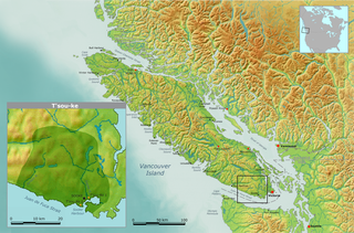
The T'sou-ke Nation of the Coast Salish peoples, is a band government whose reserve community is located on Vancouver Island, in the province of British Columbia, Canada. In February 2013, the T'sou-ke Nation had 251 registered members, with two reserves around the Sooke Basin on the Strait of Juan de Fuca at the southern end of Vancouver Island, with a total area of 67 hectares. The T'Souk-e people are the namesake of the town of Sooke, British Columbia and its surrounding harbour and basin.

The Galloping Goose Regional Trail is a 55-kilometre (34 mi) rail trail between Victoria, British Columbia, Canada, and the ghost town of Leechtown, north of Sooke, where it meets the old Sooke Flowline. Maintained by the Capital Regional District (CRD), the trail forms part of the Trans-Canada Trail, and intersects the Lochside Regional Trail. The section from Harbour Road in Esquimalt to the Veterans Memorial Parkway in Langford is also part of the Vancouver Island Trail.

French Beach Provincial Park is a provincial park in British Columbia, Canada.

The Purcell Wilderness Conservancy is a provincial park in British Columbia, Canada. It was established in 1974, and encompasses six large drainages in the Purcell Mountains in the southeast of the province. It contains high peaks, alpine meadows and ridges, deep creek and river valleys, and hot springs at Dewar Creek.

The Juan de Fuca Marine Trail is a rugged 47 kilometres (29 mi) wilderness hiking trail located within Juan de Fuca Provincial Park along the southwestern coast of Vancouver Island. The trail stretches from China Beach, 35 km west of Sooke, to Botanical Beach, just outside Port Renfrew.

Sooke Potholes Provincial Park is a 7.28 hectare provincial park in British Columbia, Canada. It is adjacent to the Sooke River and Sooke Potholes Regional Park, near Victoria, B.C. Intended primarily to provide access to the Sooke River and the associated potholes, it also offers wildlife viewing and other day-use activities.
Sooke Potholes may refer to:

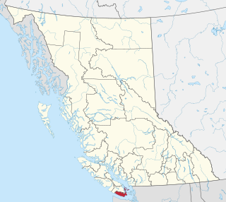
Sooke Basin is a small (10 km²) body of water on the southern end of Vancouver Island in southwestern British Columbia. It is connected to the Strait of Juan de Fuca by Sooke Harbour, a 4 km long narrow natural harbour.

The Elk/Beaver Regional Park is a 1,072-acre (434 ha) park in Saanich, British Columbia, containing Elk Lake and Beaver Lake.
Leechtown is at the confluence of the Leech River into the Sooke River in southern Vancouver Island, British Columbia. The ghost town, off BC Highway 1 is about 59 kilometres (37 mi) by road northwest of Victoria.
The Goldstream River is a river northwest of Victoria on southern Vancouver Island, British Columbia, Canada. The river's name derives from a small gold rush in its basin during the 1860s, and was originally Gold Stream.

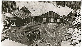
The Sooke Flowline is an abandoned 44-kilometre (27 mi) concrete aqueduct that snakes through the Sooke Hills from Sooke Lake to the Humpback Reservoir near Mt. Wells Regional Park. From this reservoir, a buried, riveted steel pressure main transported water to Victoria. Between 1994–2007, this main was replaced since it was long past its useful life. The flowline was vital to the continued growth of the City of Victoria as it provided a reliable water supply. While the flowline remains, Victoria's water supply is now carried via Kapoor tunnel. Leigh Hodgetts, CRD Waterworks superintendent, reported that the westernmost section of the flowline is still used to carry Sooke's water supply, via a 16 inch interconnecting pipe feeding the Sooke distribution system from Charters Creek to Sooke River Road.
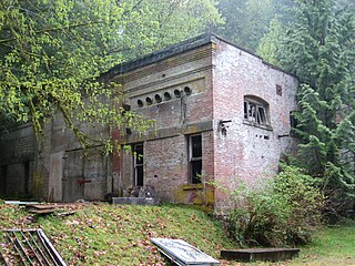
The Goldstream Powerhouse is a decommissioned hydroelectric plant located near Goldstream Provincial Park in Langford, near Victoria, British Columbia. This plant provided electricity to Victoria for 60 years and is one of the little-known and ingenious chapters in the history of Victoria. This plant was one of the first hydro plants of this type on the west coast of North America. The structure is over a century old and is unsafe to inhabit. It is within the boundaries of the watershed lands owned by the CRD and is inaccessible to the public due to its proximity to a drinking water reservoir.
The water supply system for Victoria, British Columbia, Canada, now operated by the Capital Regional District (CRD), served in 2010 over 330,000 people with clean drinking water from a catchment area of 11,025 hectares centered on its main reservoir at Sooke Lake. The CRD’s ownership and complete control of its entire watershed assures its customers of a supply that is secure in both quantity and quality. The main reservoir and its subsidiary reservoirs are estimated to contain 93 billion litres of water, enough to meet the needs of its customers for two years without any rainfall. The history of this remarkable system is sketched below.

The Sea to Sea Green Blue Belt is a 62 kilometre long greenbelt surrounding the Greater Victoria metropolitan area in Canada. The greenbelt includes green space, forests, farms, and wetlands stretching from Sooke to Salt Spring Island. It also includes the "blue spaces" of Sooke Basin and Saanich Inlet.
References
- ↑ Capital Regional District (CRD), 2010. Ayum Creek, Kapoor, Sea-to-Sea, Sooke Potholes. Regional Parks Management Plans.
- ↑ CRD, 2016. Sooke Potholes Regional Park, Spring Salmon Place Campground (KWL-UCHUN).
- ↑ "Sooke Potholes". The Land Conservancy. Retrieved 23 Dec 2019.
- ↑ Peers, Elida (22 Aug 2012). "Deertrail Resort — a ruins or a lost dream?". Sooke News Mirror. Retrieved 23 Dec 2019.
- ↑ "Abandoned Deertrail Resort". Atlas Obscura.