
The Niut Range is 3600 km2 in area. It is a subrange of the Pacific Ranges of the Coast Mountains of British Columbia, although in some classifications it is considered part of the Chilcotin Ranges. The Niut is located in the angle of the Homathko River and its main west fork, Mosley Creek. It is isolated, island-like, by those rivers from its neighbour ranges, as both streams have their source on the Chilcotin Plateau in behind the range. Razorback Mountain is its highest peak.
Anderson Bay Provincial Park is a provincial park in British Columbia, Canada, located on the southeast end of Texada Island near the community of Gillies Bay. Created in 2000, it is approximately 35 ha. in area.
Babine Lake Marine Provincial Park is a provincial park in British Columbia, Canada. The park was established by Order-in-Council in 1993, comprising two sites at Pendleton Bay totalling 36.9 hectares. Another was established in the same year at Smithers Landing, comprising approximately 157.8 hectares. Three more sites were added in 2001, Hook (Deep) Bay, Pierre Creek, Pinkut Creek and Sandpoint. All sites combined comprise approximately 492 hectares.

Bligh Island Marine Provincial Park is a provincial park in British Columbia, Canada.
Coldwater River Provincial Park is a provincial park in British Columbia, Canada, located at the confluence of the Coldwater River with Cullet Creek, 50 km south of Merritt on BC Highway 5.
Fossli Provincial Park is a provincial park in British Columbia, Canada, located on Stirling Arm of Sproat Lake on Vancouver Island. The 52-hectare park, west of Port Alberni, is accessible by water or private logging road. It has few services, but has a 30-minute hiking trail to an old homestead site. The homestead belonged to Helen and Armour Ford, who donated the land for the park to the province in 1974. Saint Andrew's Creek runs through the park, and is a fall spawning ground for coho salmon.

Harmony Islands Marine Provincial Park is a provincial park in British Columbia, Canada, located on the east side of Hotham Sound, which is a side-inlet of the lower reaches of Jervis Inlet, on that inlet's north side roughly opposite the mouth of Sechelt Inlet.
Kickininee Provincial Park is a provincial park in British Columbia, Canada, located just south of the town of Summerland in that province's Okanagan region. Originally established in 1970 with approximately 7 acres (28,000 m2) of upland and 113.5 acres (0.459 km2) of foreshore, the park today comprises approximately 48.76 ha.

Little Qualicum Falls Provincial Park is a provincial park in British Columbia, Canada, on central Vancouver Island, that encompasses the entire southern shore of Cameron Lake. The Island Rail Corridor line to Port Alberni passes through the park.
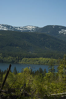
Nimpkish Lake Provincial Park is a provincial park on northern Vancouver Island, British Columbia, Canada on Vancouver Island. The park is 3,949 ha. in area and was established on 1995. It is 32 km south of Port McNeill and on the southwest side of Nimpkish Lake. Primary access is by boat launch, though radio-controlled logging roads lead to the edge of the park. Western Forest Products in Woss, British Columbia should be contacted for road advisories. The park is in the traditional territory of the Namgis First Nation.
Okeover Arm Provincial Park is a provincial park in British Columbia, Canada, located on the west side of Okeover Inlet facing Desolation Sound, on the east side of the Malaspina Peninsula.
Sabine Channel Provincial Park, also known as Sabine Channel Marine Provincial Park, is a provincial park in British Columbia, Canada, in the waters surrounding Jervis Island in Sabine Channel, which separates Texada Island (N) from Lasqueti Island (S). Established in 2001, the parks is approximately 2,254 ha. in size.

Saltery Bay Provincial Park is a provincial park in British Columbia, Canada, located southeast of the city of Powell River, and on the north side of the entrance to Jervis Inlet in the central area of that province's Sunshine Coast region.
Stuart River Provincial Park is a provincial park in British Columbia, Canada. It is located in two sections north and northwest of Vanderhoofalong the Stuart River southeast of Stuart Lake and the city of Fort St. James. The upper section is located at 54°13′20″N124°00′00″W and comprises c.7391 ha. while the lower, eastern section is centred at 54°03′00″N123°37′00″W and comprises c.3390 ha. and is within the Greater Prince George area. The upper site, which is located around the confluence of the Stuart and Nechako Rivers, includes the site of Chinlac, a Dakelh village whose inhabitants were massacred and enslaved by the Tsilhqot'in of Anahim Lake c. 1745.
The Comox Valley Regional District is a regional district in British Columbia, Canada. It was created on February 15, 2008, encompassing the southeastern portions of the former Regional District of Comox-Strathcona, and centred about the Comox Valley. The partition left the new Comox Valley Regional District with only 8.4 percent of the former Comox-Strathcona's land area, but 57.9 percent of its population. The CVRD covers an area of 2,425 square kilometres, of which 1,725 square kilometres is land, and serves a population of 66,527 according to the 2016 Census. The district borders the Strathcona Regional District to the northwest, the Alberni-Clayoquot Regional District to the southwest, and the Regional District of Nanaimo to the southeast, as well as the Powell River Regional District along the Strait of Georgia to the east.

The Ashnola River is a tributary of the Similkameen River, rising in the northeastern part of the North Cascades in Washington, United States, and flowing north into British Columbia, Canada, to join the Similkameen River about halfway along that river's course between the towns of Princeton and Keremeos. The river crosses the international boundary at 49°00′00″N120°19′37″W and transits Cathedral Provincial Park. It has one main tributary, Ewart Creek, which is about 25 kilometres (16 mi) long and begins virtually at the border and is entirely within Cathedral Park.
M'Clure Bay is a Peel Sound waterway in Qikiqtaaluk Region, Nunavut, Canada. It is located on the western side of Somerset Island, between Aston Bay and Birmingham Bay.
Musket Island Marine Provincial Park is a provincial park in British Columbia, Canada, located on the west side of Nelson Island, at the mouth of Jervis Inlet and near Earl's Cove in the Sunshine Coast region.
Horneline Creek Provincial Park is a provincial park in far northern British Columbia, Canada. It is located west of the Kechika River about 130 km south of Lower Post and 30 km north of Denetiah Provincial Park and southwest of the community of Liard River.
The Kokanee Range is a subrange of the Selkirk Mountains in the West Kootenay region of southeastern British Columbia, Canada. It is located between the valley of the Slocan River (W) and that of Kootenay Lake (E), and to the north of the Kootenay River and the West Arm of Kootenay Lake. The range includes Kokanee Glacier Provincial Park, Kokanee Peak, and Grays Peak, notable as the mountain featured on the label of Kokanee beer. The name "Kokanee" refers to a land-locked variety of Sockeye salmon.
