
The Skeena River is the second-longest river entirely within British Columbia, Canada. Since ancient times, the Skeena has been an important transportation artery, particularly for the Tsimshian and the Gitxsan—whose names mean "inside the Skeena River" and "people of the Skeena River," respectively. The river and its basin sustain a wide variety of fish, wildlife, and vegetation; and communities native to the area depend on the health of the river. The Tsimshian migrated to the Lower Skeena River, and the Gitxsan occupy territory of the Upper Skeena.

The Kitimat Ranges are one of the three main subdivisions of the Coast Mountains in British Columbia, Canada, the others being the Pacific Ranges to the south and the Boundary Ranges to the north.

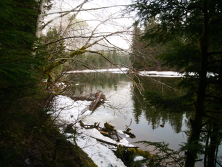
Bulkley Junction Provincial Park is a provincial park in British Columbia, Canada, located on the west side of the Skeena River opposite Hazelton. It was established in 1997 and expanded in 2004 from 133 ha. to its current size of 169 ha.
Exchamsiks River Provincial Park is a provincial park in British Columbia, Canada, located in the Range 5 Coast Land District, on the north side of the Skeena River between Terrace and Prince Rupert. The park's chief conservation role focuses on protecting one of the last known unlogged old-growth maritime coastal Sitka spruce-salmonberry ecosystems.

Foch-Gilttoyees Provincial Park is a provincial park in British Columbia, Canada. The park and protected area encompasses 61,089 hectares of coastal terrain from sea level up to alpine. The park contains part of the historical First Nations travel path between the Skeena River and the Douglas Channel. The remainder of the route is located in Gitnadoiks River Provincial Park. Together, the two parks provide a continuous protected corridor between the river and the channel.
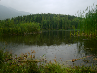
Gitnadoiks River Provincial Park is a 58,000 hectare provincial park in British Columbia, Canada. It is centred on the Gitnadoix River, a tributary of the Skeena River in Northwestern British Columbia, 50 km west of Terrace.

Kitson Island Marine Provincial Park is a provincial park protecting all 45 hectares of Kitson Island and Kitson Islet. The park is located within the asserted traditional territory of the Tsimshian and Metlakatla First Nation, at the mouth of the Skeena River in British Columbia, Canada.

Kitwanga Mountain Provincial Park is a provincial park in British Columbia, Canada located on the north side of the Skeena River just west of the Gitxsan community of Kitwanga (Gitwangak).

Kleanza Creek Provincial Park is a provincial park in British Columbia, Canada. Kleanza Creek is a tributary of the Skeena River. The park occupies over an area of 269 hectares.

Ross Lake Provincial Park is a provincial park in British Columbia, Canada. The park is located within the asserted traditional territory of the Gitxsan people, south of Nine Mile Mountain, just east of Hazelton in the Skeena Country.
Seeley Lake Provincial Park is a provincial park in British Columbia, Canada, located within the asserted traditional territory of the Gitxsan First Nation, south of the confluence of the Skeena and Bulkley Rivers.
Spatsizi Headwaters Provincial Park is a provincial park in the Stikine Region of British Columbia, Canada. It was established on January 25, 2001 to protect the headwaters of the Spatsizi River while providing recreational facilities for visitors.

The Interior Mountains or Northern Interior Mountains are the semi-official names for an expansive collection of mountain ranges that comprises much of the northern half of the Canadian province of British Columbia and a large area of southern Yukon.

The British Columbia Interior, popularly referred to as the BC Interior or simply the Interior, is a geographic region of the Canadian province of British Columbia. While the exact boundaries are variously defined, the British Columbia Interior is generally defined to include the 14 regional districts that do not have coastline along the Pacific Ocean or Salish Sea, and are not part of the Lower Mainland. Other boundaries may exclude parts of or even entire regional districts, or expand the definition to include the regional districts of Fraser Valley, Squamish–Lillooet, and Kitimat–Stikine.
The British Columbia Ministry of Transportation and Infrastructure is the British Columbia government ministry responsible for transport infrastructure and law in the Canadian province of British Columbia. It is currently led by Rob Fleming.

The Stikine Country, also referred to as the Stikine District or simply "the Stikine", is one of the historical geographic regions of the Canadian province of British Columbia, located inland from the central Alaska Panhandle and comprising the basin of the Stikine River and its tributaries. The term Stikine–Iskut is also fairly common to describe the area, and references the Iskut River, the Stikine's largest tributary and describable as its south fork.
The Klappan Range is a small subrange of the Skeena Mountains of the Interior Mountains, located between Klappan River and Iskut River in northern British Columbia, Canada.

Northern transitional alpine forests is a temperate coniferous forest ecoregion in the northwestern interior of British Columbia, as defined by the World Wildlife Fund (WWF) categorization system.
The Zymagotitz River is a tributary of the Skeena River located in the North Coast Regional District of the province of British Columbia, Canada. It originates in the Kitimat Ranges of the Coast Mountains, and flows south and west about 45 km (28 mi) to the Skeena River, about 10 km (6.2 mi) downriver from Terrace and about 100 km (62 mi) east of Prince Rupert.
