Anderson Bay Provincial Park is a provincial park in British Columbia, Canada, located on the southeast end of Texada Island near the community of Gillies Bay. Created in 2000, it is approximately 35 hectares in area.
Bishop River Provincial Park is a provincial park in the Pacific Ranges of the Coast Mountains on the Mainland of British Columbia, Canada, located southwest of and adjoining Ts'yl-os Provincial Park."Bishop River Park". BC Geographical Names. It lies along the upper course of the Bishop River, the main tributary of the Southgate River, from the Bishop's source at the western side of the Lillooet Icecap to midway along its course above its confluence with the Southgate. The park is 19,947 ha. in size. There are no roads or trails in the park although a forest service road from Waddington Harbour at the head of Bute Inlet leads up the Southgate to within a few miles of the park boundary.

Copeland Islands Marine Provincial Park is a provincial park in British Columbia, Canada, located in Desolation Sound to the northwest of Lund on the northern Sunshine Coast off the west coast of the Malaspina Peninsula.
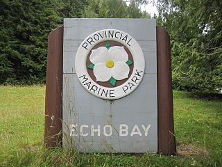
Echo Bay Marine Provincial Park is a provincial park in British Columbia, Canada, established in 1971 and containing 1.5 hectares. It is located at the bay of the same name, offshore from the community of the same name, which is the location of the Simoom Sound post office and is on the west side of Gilford Island.
Garden Bay Marine Provincial Park is a provincial park in British Columbia, Canada at the northwest end of the Sechelt Peninsula on the lower Sunshine Coast, near the community of Madeira Park. Established in 1969, it is approximately 163 ha.
Háthayim Marine Provincial Park, formerly Von Donop Marine Provincial Park, is a provincial park in British Columbia, Canada, located on the north end of Cortes Island in the Discovery Islands.
Kekuli Bay Provincial Park, formerly Kalamalka West Provincial Park, is a provincial park in British Columbia, Canada, located on the west shore of Kalamalka Lake on BC Highway 97 south of Vernon. The lake is popular for waterskiing and boating, and the park includes a boat launch, as well as a campground with a view of the lake. The park was established in 1990. Its size is about 57 hectares.
Loveland Bay Provincial Park is a provincial park on Vancouver Island, British Columbia, Canada, located on the north side of Campbell Lake, just west of the city of Campbell River.
Malaspina Provincial Park is a provincial park in British Columbia, Canada, located on the northeast side of the Malaspina Peninsula facing Desolation Sound in the northernmost area of that province's Sunshine Coast region.
Walsh Cove Provincial Park is a provincial park in located on the northeast corner of West Redonda Island in British Columbia, Canada. The park is approximately 85 ha. in size and overlooks Waddington Channel.
Paarens Beach Provincial Park is a provincial park in central British Columbia, Canada. It is located on the south-west shore of Stuart Lake, to the west of Fort St. James.
Pennask Lake Provincial Park is a provincial park in British Columbia, Canada, located on the easternmost heights of the Thompson Plateau, 50 km (31 mi) to the northwest of the Okanagan town of Peachland.
Rock Bay Marine Provincial Park is a provincial park in British Columbia, Canada, located on the Inside Passage at the junction of Johnstone Strait and Discovery Passage. The park contains approximately 525 ha. Rock Bay is located on the shore of Vancouver Island, immediately south of East Thurlow Island.

Saltery Bay Provincial Park is a provincial park in British Columbia, Canada. The park is located southeast of the city of Powell River, and on the north side of the entrance to Jervis Inlet in the central area of the province's Sunshine Coast region.
Smelt Bay Provincial Park is a provincial park in British Columbia, Canada. It is located at the south end of Cortes Island, and has twenty-two camping sites. Eight are reservable and the rest are first-come, first-served. There is also an overflow parking lot directly next to the beach for any excess campers.
Sowchea Bay Provincial Park is a provincial park in central British Columbia, Canada. It is on Stuart Lake, west of Prince George. The park is 13 hectares in area. It is a busy destination for boaters and anglers, with a single-lane concrete boat launch available with limited parking.

Squitty Bay Provincial Park is a provincial park in British Columbia, Canada, located on Lasqueti Island in the Northern Gulf Islands of the Strait of Georgia region.
Thurston Bay Marine Provincial Park is a provincial park on the northwest side of Sonora Island in British Columbia, Canada.
Teakerne Arm Provincial Park is a provincial park in British Columbia, Canada, located on the north shore of Teakerne Arm on West Redonda Island in the Discovery Islands archipelago, to the northeast of the city of Campbell River, Canada.
The Dall River is a river in northern British Columbia, Canada, flowing northwest into the Turnagain River, a tributary of the Kechika, to the west of Mount Skook Davidson. Originally named the Cold Fish River, it was renamed in 1944 to avoid confusion with another river of that name that is a tributary of the Spatsizi, and because of the presence of Dall's sheep in the area. Dall Lake is along its course, south of Dall River Old Growth Provincial Park, which lies between the lake and the confluence with the Turnagain. Denetiah Provincial Park, on the river's upper course, includes Dall Lake.


