


Related Research Articles

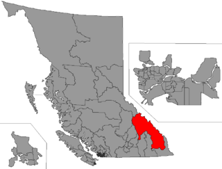
The Columbia–Shuswap Regional District is a regional district in the Canadian province of British Columbia, located in the Southern Interior region on the Trans-Canada Highway between Vancouver and Calgary, Alberta. The regional district borders the Province of Alberta across the Rocky Mountains.

Shuswap Lake is a lake located in the southern interior of British Columbia, Canada that drains via the Little Shuswap River into Little Shuswap Lake. Little Shuswap Lake is the source of the South Thompson River, a branch of the Thompson River, a tributary of the Fraser River. It is at the heart of a region known as the Columbia Shuswap or "the Shuswap", noted for its recreational lakeshore communities including the city of Salmon Arm. The name "Shuswap" is derived from the Shuswap or Secwepemc First Nations people, the most northern of the Interior Salish peoples, whose territory includes the Shuswap. The Shuswap call themselves /ʃǝxwépmǝx/ in their own language, which is called /ʃǝxwepmǝxtʃín/, but the ethnonym's original meaning is now lost.

Shuswap is a provincial electoral district for the Legislative Assembly of British Columbia, Canada.
Columbia River-Revelstoke is a provincial electoral district for the Legislative Assembly of British Columbia, Canada.

Sicamous is a district municipality in British Columbia located adjacent to the Trans-Canada Highway at the Highway 97A junction, where Mara Lake empties into Shuswap Lake via a short narrows. Sicamous is a resort town about halfway between Calgary and Vancouver and is the eastern gateway to the Apple Country. With 341 km (212 mi) of shoreline, it styles itself as the houseboat capital of Canada. It has a population of 3,166.
Salmon Arm was the name of a provincial electoral district in the Canadian province of British Columbia including on the town of Salmon Arm on Shuswap Lake. The riding first appeared in the 1924 election. After the 1966 election there was a redistribution with the resulting riding in the same area being Shuswap.
Cinnemousun Narrows Provincial Park is a provincial park in British Columbia, Canada, located on Shuswap Lake at the convergence of the lake's four arms.

Mara Provincial Park is a day-use provincial park in British Columbia, Canada, located on Mara Lake south of Sicamous. The park is open with services from May 1 to September 27. The gate is locked open during the off season.
Monte Creek Provincial Park is a provincial park in British Columbia, Canada, located in the locality of Monte Creek, British Columbia. Created in 1996, it is only 3 hectares in size, and protects a treed river riparian area and also quiggly hole ("kekuli") sites of the Shuswap people, which have been formally studied as an archaeological site. The location was also part of the route of the Hudson's Bay Brigade Trail to the Cariboo via Kamloops from what is now the United States, as was also Monte Lake in the upper basin of the eponymous creek.
Porcupine Meadows Provincial Park is a 2,704 hectare provincial park in British Columbia, Canada, located north of Tranquille Lake to the northwest of Kamloops. Its name is a direct translation of the Shuswap word for this area, "pisitsoolsia", named so for the numerous porcupine in the area.

Shuswap Lake Provincial Park is a provincial park in British Columbia, Canada.
Silver Beach Provincial Park is a provincial park in British Columbia, Canada, located at the head of the Seymour Arm of Shuswap Lake in that province's Shuswap Country, adjacent to the settlement of Seymour Arm.
Skookumchuck Rapids Provincial Park is a provincial park in British Columbia, Canada, located on the Shuswap River just below the outlet of Mabel Lake. This park was established as a result of the Okanagan-Shuswap Land and Resource Management Plan.
Sunnybrae Provincial Park is a provincial park in British Columbia, Canada, located on the northern side of the Salmon Arm of Shuswap Lake, near the city of Salmon Arm. Sunnybrae is a day use park with washrooms, picnic tables, playground and swimming area.
Shuswap may refer to:
Scotch Creek is a small community in British Columbia based on summer tourism located on the shores of Shuswap Lake at the mouth of the creek of the same name.

The British Columbia Interior, popularly referred to as the BC Interior or simply the Interior, is a geographic region of the Canadian province of British Columbia. While the exact boundaries are variously defined, the British Columbia Interior is generally defined to include the 14 regional districts that do not have coastline along the Pacific Ocean or Salish Sea, and are not part of the Lower Mainland. Other boundaries may exclude parts of or even entire regional districts, or expand the definition to include the regional districts of Fraser Valley, Squamish–Lillooet, and Kitimat–Stikine.
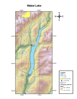
Mabel Lake is a lake located in southern Interior British Columbia, Canada, that is fed by and drained by the Shuswap River. It is located southeast of Shuswap Lake, northeast of Okanagan Lake, and west of the Monashee Mountains, and is popular for camping and fishing. The area around the lake is mountainous and sparsely populated.
There are two BC mountains recognized as Mount Ida: one located in the Continental Ranges and the other in the Shuswap Highland.
References
- ↑ "B.C.'s most popular parks might surprise you". CBC. 2019-06-28. Retrieved 2020-08-27.