Related Research Articles

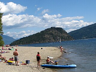
Salmon Arm is a city in the Columbia Shuswap Regional District of the Southern Interior of the Canadian province of British Columbia that has a population of 17,706 (2016). Salmon Arm became a city on May 15, 1905 and is now the location of the head offices of the Columbia-Shuswap Regional District. It is a tourist town in the summer, with many beaches, camping facilities and house boat rentals. Salmon Arm is home to the longest wooden wharf in North America.

The Columbia-Shuswap Regional District is a regional district in the Canadian province of British Columbia, located in the Southern Interior region on the Trans-Canada Highway between Vancouver and Calgary, Alberta. The regional district borders the Province of Alberta across the Rocky Mountains.

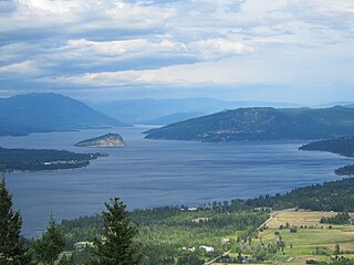
Shuswap Lake is a lake located in the southern interior of British Columbia, Canada that drains via the Little Shuswap River into Little Shuswap Lake. Little Shuswap Lake is the source of the South Thompson River, a branch of the Thompson River, a tributary of the Fraser River. It is at the heart of a region known as the Columbia Shuswap or "the Shuswap", noted for its recreational lakeshore communities including the city of Salmon Arm. The name "Shuswap" is derived from the Shuswap or Secwepemc First Nations people, the most northern of the Interior Salish peoples, whose territory includes the Shuswap. The Shuswap call themselves /ʃǝxwépmǝx/ in their own language, which is called /ʃǝxwepmǝxtʃín/, but the ethnonym's original meaning is now lost.

The City of Enderby is in the North Okanagan region of the Canadian province of British Columbia, between Armstrong and Salmon Arm. It is approximately 80 km north of Kelowna and 130 km east of Kamloops. Highway 97A passes through Enderby and the Shuswap River marks the eastern and northeastern limits of the City. There are two major schools in Enderby: M.V. Beattie Elementary School and A.L. Fortune Secondary School. M.V. Beattie Elementary School was rebuilt in 2012.
The basin of the Shuswap River lies northeast of the Okanagan Valley in British Columbia, originating in the central Monashee Mountains. It is the upper part of the drainage better known to British Columbians as belonging to Shuswap Lake and the South Thompson River. The river's drainage basin is over 1,969 square kilometres (760 sq mi) in area.

Adams Lake Provincial Park is a provincial park in British Columbia, Canada. It encompasses three distinct parks: Adams Lake Provincial Park, Adams Lake Marine Provincial Park, and Adams Lake Marine Provincial Park.
Cinnemousun Narrows Provincial Park is a provincial park in British Columbia, Canada, located on Shuswap Lake at the convergence of the lake's four arms.
Elephant Hill Provincial Park is a provincial park in British Columbia, Canada protecting Elephant Hill, a prominent landmark adjacent to the Trans-Canada Highway at the cut-off for the town of Ashcroft a few miles south of the town of Cache Creek. The park is approximately 968 hectares in area.
Herald Provincial Park is a provincial park in British Columbia, Canada.
Malaspina Provincial Park is a provincial park in British Columbia, Canada, located on the northeast side of the Malaspina Peninsula facing Desolation Sound in the northernmost area of that province's Sunshine Coast region.
Monte Creek Provincial Park is a provincial park in British Columbia, Canada, located in the locality of Monte Creek, British Columbia. Created in 1996, it is only 1.7 hectares in size, and protects a treed river riparian area and also quiggly hole ("kekuli") sites of the Shuswap people, which have been formally studied as an archaeological site. The location was also part of the route of the Hudson's Bay Brigade Trail to the Cariboo via Kamloops from what is now the United States, as was also Monte Lake in the upper basin of the eponymous creek.
Pukeashun Provincial Park is a provincial park in British Columbia, Canada, located north of the community of Scotch Creek, near the city of Salmon Arm. The park is named for Pukeashun Mountain which is within its boundaries and a major local landmark. It protects part of the Adams Plateau, the southeastern portion of the Shuswap Highland.

Shuswap Lake Provincial Park is a provincial park in British Columbia, Canada.
Shuswap Lake Marine Provincial Park is an 896-hectare provincial park in British Columbia, Canada, comprising 991 ha. The Park has a variety of amenities including boat launch ramps, picnic areas, and 27 campsites around the perimeter of Shuswap Lake. The lake's name and that of the surrounding Shuswap Country is from the Shuswap people (Secwepemc), the most northern of the Salishan speaking people.
Skookumchuck Rapids Provincial Park is a provincial park in British Columbia, Canada, located on the Shuswap River just below the outlet of Mabel Lake. This park was established as a result of the Okanagan-Shuswap Land and Resource Management Plan.
The Lower Similkameen Indian Band or Lower Smelqmix, is a First Nations band government in the Canadian province of British Columbia. Their office is located in the village of Keremeos in the Similkameen region. They are a member of the Okanagan Nation Alliance.

Canoe, British Columbia, is a semi-rural community in British Columbia within the larger City of Salmon Arm. The community lies on the south side of Shuswap Lake, northeast of the city centre, just off the Trans Canada Highway. Canoe is home to the Canoe Forest Products plywood plant, which processes lumber from the surrounding forests for sale and export.
The Shuswap Country, or simply the Shuswap and called Secwepemcúl̓ecw in Secwepemctsín, is a term used in the Canadian province of British Columbia to refer to the environs of Shuswap Lake. The upper reaches of the Shuswap basin, southeast of Shuswap Lake and northeast of the Okanagan, are generally considered to be part of Okanagan or of the Monashee Country rather than "the Shuswap". Roughly defined, the Shuswap Country begins on its west at the town of Chase, located on Little Shuswap Lake, west of which is the South Thompson area of the Thompson Country, and includes Adams Lake to the northwest of Shuswap Lake as well as communities in the Eagle River area as far as Craigellachie and/or Three Valley Gap, which is at the summit of Eagle Pass, beyond which eastwards is the Columbia Country.

The Adams River is a tributary to the Thompson and Fraser Rivers in British Columbia, Canada. Beginning in the Monashee Mountains to the north, the Upper Adams River flows mainly southward and eventually reaches Adams Lake. The Lower Adams River begins at the southern end of the lake and flows into the extreme western end of Shuswap Lake. The river is one of the most important sockeye salmon breeding areas in North America. The run occurs in mid-October and can bring millions of fish to a concentrated area near the river mouth. Excavations of Secwepemc villages on the river have shown a long tradition of habitation and salmon fishing in the area. The river also served as an important transportation route for early logging operations in the watershed.
Oregana Creek Provincial Park is a provincial park in British Columbia, Canada, located 150 kilometres northwest of Salmon Arm, British Columbia, near Adams River. The park, which is 286 ha. in size, was established in 2010.
References
- ↑ "Sunnybrae Park | Columbia Shuswap Regional District". www.csrd.bc.ca. Retrieved 2020-10-02.
| This British Columbia protected areas related article is a stub. You can help Wikipedia by expanding it. |
Coordinates: 50°46′00″N119°18′00″W / 50.76667°N 119.30000°W