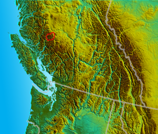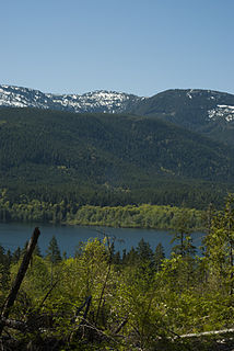
The Niut Range is 3600 km2 in area. It is a subrange of the Pacific Ranges of the Coast Mountains of British Columbia, although in some classifications it is considered part of the Chilcotin Ranges. The Niut is located in the angle of the Homathko River and its main west fork, Mosley Creek. It is isolated, island-like, by those rivers from its neighbour ranges, as both streams have their source on the Chilcotin Plateau in behind the range. Razorback Mountain is its highest peak.

Adams Lake Provincial Park is a provincial park in British Columbia, Canada. It encompasses three distinct parks: Adams Lake Provincial Park, Adams Lake Marine Provincial Park, and Adams Lake Marine Provincial Park.

Copeland Islands Marine Provincial Park is a provincial park in British Columbia, Canada, located in Desolation Sound to the northwest of Lund on the northern Sunshine Coast off the west coast of the Malaspina Peninsula.

Eakin Creek Canyon Provincial Park is a provincial park in British Columbia, Canada, located on the west side of the North Thompson River near the community of Little Fort. The park is approximately 10 ha. in size.

Fossli Provincial Park is a provincial park in British Columbia, Canada, located on Stirling Arm of Sproat Lake on Vancouver Island. The 52-hectare park, west of Port Alberni, is accessible by water or private logging road. It has few services, but has a 30-minute hiking trail to an old homestead site. The homestead belonged to Helen and Armour Ford, who donated the land for the park to the province in 1974. Saint Andrew's Creek runs through the park, and is a fall spawning ground for coho salmon.

Francis Point Provincial Park is a provincial park in British Columbia, Canada, located on the southwest end of the Francis Peninsula, south of the community of Pender Harbour on the west side of the Sechelt Peninsula in the Sunshine Coast region. Established in 2004, the park is 81 ha. in size, 72 ha. of it upland, the other 9 ha. foreshore.

Junction Sheep Range Provincial Park is a provincial park in British Columbia, Canada, located near the confluence of the Chilcotin and Fraser Rivers on the west bank of the latter river.

Juan de Fuca Provincial Park is a provincial park located on the west coast of Vancouver Island in British Columbia, Canada. The park was established on April 4, 1996 by combining three former parks - China Beach, Loss Creek, and Botanical Beach - into one provincial park. It is the location of the majority of the Juan de Fuca Marine Trail, which is a southern compliment to the West Coast Trail within Pacific Rim National Park Reserve.

Kootenay Lake Provincial Park is a provincial park in British Columbia, Canada. It encompasses five widely dispersed parks around Kootenay Lake: Kootenay Lake Provincial Park, Kootenay Lake Provincial Park, Kootenay Lake Provincial Park, Kootenay Lake Provincial Park, and Kootenay Lake Provincial Park.

Kingfisher Creek Provincial Park is a provincial park in British Columbia, Canada located 15 km southeast of Sicamous and west of Mabel Lake in the Monashee Mountains. The park is 440 hectares and was created to enhance the viability of the Kingfisher Creek Ecological Preserve.

Lockhart Creek Provincial Park is a provincial park in British Columbia, Canada, located adjacent to Lockhart Beach Provincial Park, 40 km north of Creston, British Columbia on the east shore of Kootenay Lake.

Mount Elphinstone Provincial Park is a provincial park in British Columbia, Canada. Located near Mount Elphinstone, the park is on the west side of Howe Sound and north of the town of Gibsons and near the community of Roberts Creek. Created in 2000, the park is approximately 141 hectares in size.

Niskonlith Lake Provincial Park is a provincial park in British Columbia, Canada, located southwest of the town of Chase.

Walsh Cove Provincial Park is a provincial park in located on the northeast corner of West Redonda Island in British Columbia, Canada. The park is approximately 85 ha. in size and overlooks Waddington Channel.

Painted Bluffs Provincial Park is a provincial park in British Columbia, Canada, located on the north side of Kamloops Lake at the outlet of Copper Creek.

Sechelt Inlets Marine Provincial Park is a provincial park in British Columbia, Canada, at various locations on Sechelt Inlet, Salmon Inlet and Narrows Inlet, near Sechelt. Established initially as a recreation area in 1980, it was converted to a park in 1999, containing approximately 140 hectares.
Teakerne Arm Provincial Park is a provincial park in British Columbia, Canada, located on the north shore of Teakerne Arm on West Redonda Island in the Discovery Islands archipelago, to the northeast of the city of Campbell River, Canada.
China Beach is a beach on the west coast of Vancouver Island, British Columbia, Canada, southeast of the town of Port Renfrew. The name is derived from the former name of Uglow Creek, formerly known as China Creek. The beach was formerly the name of a provincial park, now rescinded.

Horneline Creek Provincial Park is a provincial park in far northern British Columbia, Canada. It is located west of the Kechika River about 130 km south of Lower Post and 30 km north of Denetiah Provincial Park and southwest of the community of Liard River.

Nitinat Lake is a large lake and inlet on the south-western coast of Vancouver Island, British Columbia, Canada. The lake is about 150 km (93 mi) north-west by road from Victoria, BC's capital on the southern tip of Vancouver Island, and about 60 km (37 mi) south-west by road from the town of Lake Cowichan. The city of Port Alberni is about 80 km (50 mi) by road to the north.


