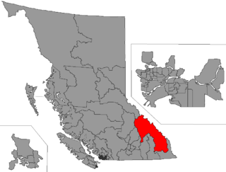
Columbia River-Revelstoke is a provincial electoral district for the Legislative Assembly of British Columbia, Canada.

The Columbia Mountains are a group of mountain ranges along the upper Columbia River in British Columbia, Montana, Idaho and Washington. The mountain range covers 135,952 km². The range is bounded by the Rocky Mountain Trench on the east, and the Kootenay River on the south; their western boundary is the edge of the Interior Plateau. Seventy-five percent of the range is located in Canada and the remaining twenty-five percent in the United States; American geographic classifications place the Columbia Mountains as part of the Rocky Mountains complex, but this designation does not apply in Canada. Mount Sir Sandford is the highest mountain in the range, reaching 3,519 metres (11,545 ft).

Mica Creek is a small village in British Columbia, Canada that was used as a base of operations for the construction of the Mica Dam hydroelectric project by BC Hydro in the 1960s and 1970s. It is located 148 km north of Revelstoke, British Columbia on Highway 23 and situated at the convergence of the Revelstoke Lake and a stream called Mica Creek. The village is effectively a relocation of Mica, which had been at the confluence of the Columbia and Mica Creek proper. The creek itself was named for the flakes of mica minerals which could be found floating in its waters. The Mica Creek area was one of the foci of the Big Bend Gold Rush of the 1860s.
Revelstoke was a provincial electoral district in the Canadian province of British Columbia. It made its first appearance on the hustings in the election of 1903 and lasted until the 1928 election, after which the revised riding was merged with the Slocan riding to form Revelstoke-Slocan. The riding has since been represented by Shuswap-Revelstoke and is currently represented by Columbia River-Revelstoke.

Arrow Lakes Provincial Park is a provincial park in British Columbia, Canada.
Boundary Creek Provincial Park is a provincial park in British Columbia, Canada located south of Greenwood BC in that province's Boundary Country, adjacent to BC Highway 3. The eponymous Boundary Creek flows through the park.
Blanket Creek Provincial Park is a provincial park in British Columbia, Canada. It hosts one of the nearest campgrounds for visitors going to the Mount Revelstoke National Park.

Victor Lake Provincial Park is a provincial park in British Columbia, Canada, located southwest of Revelstoke to the north of Three Valley Lake.
English Lake Provincial Park is a provincial park in British Columbia, Canada. Located near Revelstoke, British Columbia, English Lake Provincial Park has an area of 337 hectares.

Hamber Provincial Park is a provincial park in British Columbia, Canada, located at the provincial boundary with Alberta, surrounded on three sides by Jasper National Park. When the park was created in 1941, it constituted one of the largest protected wilderness areas in Canada. In the early 1960s, the provincial government reduced its size by 98% due to pressure exerted by the forestry industry, planned hydroelectric developments along the upper Columbia River and the re-routing of the Trans-Canada Highway away from the park.
James Chabot Provincial Park is a provincial park in British Columbia, Canada. Formerly Athalmer Beach Provincial Park, it is located in Invermere at the northeast end of Windermere Lake in the Columbia Valley region of the East Kootenay. Windermere Lake Provincial Park is located at the lake's southwestern end.

Kokanee Creek Provincial Park is a provincial park on the west shore of Kootenay Lake in the West Kootenay region of southeastern British Columbia. Highway 3A bisects the park 19 kilometres (12 mi) east of Nelson.
Norm Macdonald is a former Member of the Legislative Assembly of British Columbia and a member of the British Columbia New Democratic Party. He was elected to the Legislative Assembly from the riding of Columbia River-Revelstoke in the 2005 provincial election and re-elected in the 2009 election and the 2013 election, though his party formed the official opposition to a BC Liberal majority government each time. He served various critic roles and on several committees.
William 'Bill' King was a former British Columbia politician from Revelstoke. King was a member of Dave Barrett's 1972 BC NDP provincial government, serving in the post of Minister of Labour.

The era of steamboats on the Arrow Lakes and adjoining reaches of the Columbia River is long-gone but was an important part of the history of the West Kootenay and Columbia Country regions of British Columbia. The Arrow Lakes are formed by the Columbia River in southeastern British Columbia. Steamboats were employed on both sides of the border in the upper reaches of the Columbia, linking port-towns on either side of the border, and sometimes boats would be built in one country and operated in the other. Tributaries of the Columbia include the Kootenay River which rises in Canada, then flows south into the United States, then bends north again back into Canada, where it widens into Kootenay Lake. As with the Arrow Lakes, steamboats once operated on the Kootenay River and Kootenay Lake.

The Big Bend Highway is a 305 km (190 mi) former highway in the interior of British Columbia, was the original alignment of British Columbia Highway 1 which followed the Columbia River between Revelstoke and Golden through the Selkirk Mountains.

The Clachnacudainn Range is a subrange of the Selkirk Mountains in southeastern British Columbia, Canada, located within Mount Revelstoke National Park, just northeast of Revelstoke. It was named by Arthur Wheeler in reference to the Clachnacudainn charter stone, located in Inverness, Scotland. The range is bounded by the Illecillewaet River to the south, Lake Revelstoke to the west, and Carnes and Woolsey Creeks to the north and east. The highest point in the range is Mount Coursier at 2,648 metres (8,688 ft).

Kamloops Transit operates the public bus transit system in the City of Kamloops in south central British Columbia, Canada. The system consists of 18 regularly scheduled routes, one Sunday route, several school specials and handyDART customized service for those with a disability. Funding is provided through a partnership between the City of Kamloops and BC Transit, the provincial agency which plans and manages municipal transit systems. Operations are contracted out to FirstCanada ULC. The transit system began development in 1975 after the Province of British Columbia began offering subsidies to help operate local transit systems in local communities.
BC Transit Health Connections or simply Health Connections are a supplementary interregional public transit bus service provided by BC Transit in various communities throughout the province of British Columbia. While, as the title implies, the scheduled services are geared towards passengers needing to reach an urban centre for health reasons, all are able to use the service if space allows.