
Anstey-Hunakwa Provincial Park is a provincial park in the Shuswap Country of the Southern Interior of British Columbia, Canada. 6,852 hectares in size, the park was established April 18, 2001.
Babine Mountains Provincial Park is a provincial park in British Columbia, Canada, located to the east of the Bulkley River between the town of Smithers (SW) and Babine Lake (NE). Established by Order-in-Council as the Babine Mountains Recreation Area in 1984, it was upgraded to park status and its name changed in 1999. It contains approximately 31,465 hectares.
Buckinghorse River Wayside Provincial Park is a provincial park in British Columbia, Canada located on the Alaska Highway, approximately 175 km northwest of the city of Fort St. John. It is located on the north side of the Buckinghorse River, to the northwest of the community of Pink Mountain. The park is 36 ha. in size and is near the community of Buckinghorse River.
Boulder Creek Provincial Park is a provincial park in British Columbia, Canada, located to the west of BC Highway 16 near Smithers, in the Bulkley Valley.
Bishop River Provincial Park is a provincial park in the Pacific Ranges of the Coast Mountains on the Mainland of British Columbia, Canada, located southwest of and adjoining Ts'yl-os Provincial Park."Bishop River Park". BC Geographical Names. It lies along the upper course of the Bishop River, the main tributary of the Southgate River, from the Bishop's source at the western side of the Lillooet Icecap to midway along its course above its confluence with the Southgate. The park is 19,947 ha. in size. There are no roads or trails in the park although a forest service road from Waddington Harbour at the head of Bute Inlet leads up the Southgate to within a few miles of the park boundary.
Coste Rocks Provincial Park is a provincial park in British Columbia, Canada, located 23 km south of Kitimat on the south end of Coste Island. The park, which is water access only, was established in 2004; comprising approximately 29 hectares.
Dala-Kildala Rivers Estuaries Provincial Park is a provincial park of 452 ha. in British Columbia, Canada. It protects the mouth of the Dala River in Kildala Arm.
Eagle Bay Provincial Park is a provincial park in British Columbia, Canada which covers 262 hectares of land.
Green Inlet Marine Provincial Park is a provincial park in British Columbia, Canada, located in the North Coast region to the southeast of Butedale and containing 33 ha.

Lakelse Lake Provincial Park is a provincial park in British Columbia, Canada located just west of Highway 37 between Terrace and Kitimat. The name is derived from the Coast Tsimshian language word "LaxGyels" - "fresh water mussel", for the mollusk that is found on the bottom of both Lakelse Lake and Lakelse River. Prior to Lakelse Lake becoming a provincial park, Hatchery Creek, which runs throughout the park, was the site of a sockeye salmon hatchery operated by the Canadian Government between 1919 and 1936. Lakelse Lake Provincial Park was established on March 16, 1956.

Little Qualicum Falls Provincial Park is a provincial park in British Columbia, Canada, on central Vancouver Island, that encompasses the entire southern shore of Cameron Lake.

Read Island Provincial Park is a provincial park in British Columbia, Canada. It is located on the south end of Read Island. Established in 1996, the park contains approximately 637 ha.
Sleeping Beauty Mountain Provincial Park is a provincial park in British Columbia, Canada. It is located in the watershed of the Zymagotitz River.

The Hazelton Mountains are a grouping of mountain ranges on the inland lee of the Kitimat Ranges of the Coast Mountains in northwestern British Columbia, Canada, spanning the area of Hazelton south to the Nechako Reservoir. Defined by the British Columbia geographic names office, they span from the Nass River to the Nechako Plateau, and between the Coast Mountains and the Bulkley River, they are considered by geographers to be part of the Interior Mountains complex, though in local perspective they are considered to be part of the Coast Mountains. They are neighboured on the west by the Kitimat Ranges and on the east by the southernmost section of the Skeena Mountains; beyond the Nass River, which is their northern boundary, are the Boundary Ranges of the Coast Mountains. To their southeast is the Nechako Plateau, including the Quanchus Range on the near-island between Ootsa and Eutsuk Lakes of the Nechako Reservoir.
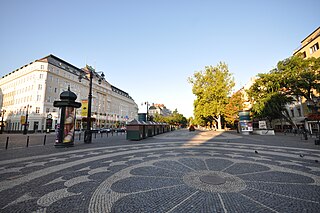
Hviezdoslavovo námestie is a town square in Bratislava. It is located in the Old Town, between the New Bridge and the Slovak National Theater. The square is named after Pavol Országh Hviezdoslav. This square has existed in the Kingdom of Hungary for 1000 years.

Kitwanga or Gitwangak or Gitwangax is located where the Kitwanga River runs into the Skeena River in British Columbia. A long-standing village before contact, the village is within Gitwangak Indian Reserve No. 1.
The Kitwanga River is a tributary of the Skeena River near Hazelton in northwestern British Columbia, Canada, joining that stream at the community of Kitwanga (Gitwangak), which means "people of the place of rabbits".

Gitanyow is an Indian reserve community of the Gitxsan people, located on the Kitwanga River 8 km south of Kitwancool Lake, at the confluence of Kitwancool Creek. The community is located on Gitanyow Indian Reserve No. 1.
Mount Gunanoot is a mountain in the Spatsizi Plateau of the North-Central Interior of British Columbia, Canada, located just east of the headwaters of the Spatsizi River. It is named for Simon Gunanoot, a Gitxsan packer, entrepreneur and erstwhile fugitive who was hunted for several years before turning himself in for trial and being acquitted. Gunanoot is responsible for "opening up" most of the country in this region.

Kananaskis Village is an unincorporated community in Alberta's Rockies within the Kananaskis Country park system in the Kananaskis Improvement District of Alberta, Canada. It is located approximately 26 km (16 mi) south of the Trans-Canada Highway, 3 km (1.9 mi) west of Highway 40 via Mt. Allan Drive and Centennial Drive. The community is located on the west shore of the Kananaskis River at the base of Mount Kidd.
