
The Township of Langley is a district municipality immediately east of the City of Surrey in southwestern British Columbia, Canada. It extends south from the Fraser River to the Canada–United States border, and west of the City of Abbotsford. Langley Township is not to be confused with the City of Langley, which is adjacent to the township but politically is a separate entity. Langley is located in the eastern part of Metro Vancouver.

Charles Lee Tilden Regional Park, also known as Tilden Park or Tilden, [], is a 2,079-acre (841 ha) regional park in the East Bay, part of the San Francisco Bay Area in California. It is between the Berkeley Hills and San Pablo Ridge. Its main entrance is near Kensington, Berkeley, and Richmond. The park is contiguous with Wildcat Canyon Regional Park.

Armstrong Redwoods State Natural Reserve is a state park of California in the United States established to preserve 805 acres (326 ha) of coast redwoods. The reserve is located in Sonoma County, just north of Guerneville.
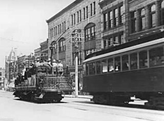
The British Columbia Electric Railway (BCER) was an historic railway which operated in southwestern British Columbia, Canada. Originally the parent company for, and later a division of, BC Electric Company, the BCER assumed control of existing streetcar and interurban lines in southwestern British Columbia in 1897, and operated the electric railway systems in the region until the last interurban service was discontinued in 1958. During and after the streetcar era, BC Electric also ran bus and trolleybus systems in Greater Vancouver and bus service in Greater Victoria; these systems subsequently became part of BC Transit, and the routes in Greater Vancouver eventually came under the control of TransLink. Trolley buses still run in the City of Vancouver with one line extending into Burnaby.

The City of Langley, commonly referred to as Langley City, or just Langley, is a municipality in the Metro Vancouver Regional District in British Columbia, Canada. It lies directly east of Surrey, adjacent to the Cloverdale area, and is surrounded elsewhere by the Township of Langley, bordered by its neighbourhoods of Willowbrook to the north, Murrayville to the east, and Brookswood and Fern Ridge to the south.

Coyote Hills Regional Park is a regional park encompassing nearly 978 acres of land and administered by the East Bay Regional Park District. The park, which was dedicated to public use in 1967, is located in Fremont, California, USA, on the southeast shore of the San Francisco Bay. The Coyote Hills themselves are a small range of hills at the edge of the bay; though not reaching any great height, they afford tremendous views of the bay, three of the trans-bay bridges, the cities of San Francisco and Oakland, the Peninsula Range of the Santa Cruz Mountains and Mount Tamalpais. In addition to the hills themselves, the park encloses a substantial area of wetlands.

Fort Langley is a village community in Township of Langley, British Columbia, Canada. It has a population of approximately 3,400 people. It is the home of Fort Langley National Historic Site, a former fur trade post of the Hudson's Bay Company. Lying on the Fraser River, Fort Langley is at the northern edge of the Township of Langley.
Summit Metro Parks is a Metroparks system serving the citizens of Summit County, Ohio by managing 14,000 acres (5,700 ha) in 16 developed parks, six conservation areas and more than 150 miles (240 km) of trails, with 22.4 miles (36.0 km) of the Ohio & Erie Canal Towpath Trail.

The North Shore Mountains are a mountain range overlooking Vancouver in British Columbia, Canada. Their southernmost peaks are visible from most areas in Vancouver and form a distinctive backdrop for the city.
Sawyer Camp Trail is a popular 6-mile (9.7 km) trail located in the San Andreas Fault rift valley in San Mateo County, California near Hillsborough and the San Mateo Highlands. Officially, it is a segment of the longer Crystal Springs Regional Trail. Approximately 300,000 people use the trail every year. It provides excellent views of San Francisco Peninsula's Crystal Springs Watershed. The trail is managed by San Mateo County and totally surfaced in asphalt. There is considerable biodiversity along the trail due to the variation in habitat and the presence of serpentine soils. In particular the plant communities of Northern coastal scrub, grassland and California oak woodland are present.
Ralph B. Clark Regional Park is an urban park located in the cities of Fullerton and Buena Park, California. The park is maintained by Orange County Regional Parks, the government division that controls the regional parks in Orange County. The park is south of Rosecrans Avenue at the southern edge of the West Coyote Hills in Buena Park, but both a small section named Camel Hill next to the main park area south of Rosecrans and another small section of the park with six softball fields and a trail located north of Rosecrans Avenue are within Fullerton city limits. The park was originally opened as Los Coyotes Regional Park in 1981, and was renamed in 1987 after then-retiring Orange County Supervisor Ralph B. Clark (1917–2009).

Rancho San Antonio County Park and Rancho San Antonio Open Space Preserve are a conjoined public recreational area in the Santa Cruz Mountains, in the northwest quadrant of Santa Clara County, California. The County Park is bordered by Los Altos with some parts of the eastern part of the County Park in western Cupertino. The Open Space Preserve is on the west side of the County Park, also bordered by Los Altos Hills, Monte Bello Open Space Preserve, and the Permanente Quarry.

Minnekhada Regional Park is a natural park situated in northeast Coquitlam, British Columbia, alongside Pitt-Addington Marsh and the Pitt River. It is over 200 hectares in size, and features trails, rock knolls, abundant trees, birds and other wildlife. At the centre of the park is the main marsh area, divided into upper and lower sections, divided by a dike and small footbridge.

The Jordan River Parkway is an approximately 40-mile (64 km) urban park that runs along the Jordan River within the U.S. state of Utah. The parkway follows along the river from Utah Lake in Utah County, through Salt Lake County and onto the Great Salt Lake in Davis County. The majority of a mixed-use trail has been completed with a shared-use path for cyclists, skaters, and joggers. A separate equestrian path runs on the southern portion of the trail. Many trail-heads, city and county parks and golf courses are also located along the parkway.

Graham Oaks Nature Park is a 250 acres (100 ha) nature park in Wilsonville in the U.S. state of Oregon. Opened in 2010, the park is owned and operated by Metro, the regional government in the Oregon portion of the Portland metropolitan area.

Western Sydney Regional Park is a large urban park and a nature reserve situated in Western Sydney, Australia within the suburbs of Horsley Park and Abbotsbury. A precinct of Western Sydney Parklands, a park system, and situated within the heart of the Cumberland Plain Woodland, the regional park features several picnic areas, recreational facilities, equestrian trails, and walking paths within the Australian bush.

Croft State Park is a state park in Spartanburg County, South Carolina, located on land used during World War II as Camp Croft, a US Army basic training center and prisoner-of-war camp.
Lynn Headwaters Regional Park is an area of North Vancouver, British Columbia, and is the largest of twenty-two regional parks in Metro Vancouver. At 9,216.5 acres (3,729.8 ha), the park boasts a variety of trails for hikers, including easy, intermediate, and challenging. The trails are colour-coded and range from 3 kilometres (1.9 mi) to 21.4 kilometres (13.3 mi). Bikes and dogs are allowed on select trails.

Central Park is a 90-hectare (220-acre) urban park in Burnaby, British Columbia, founded in 1891.


