
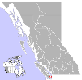
Gulf Islands National Park Reserve is a national park located on and around the Gulf Islands in British Columbia, Canada. In the National Parks System Plan, this park provides representation of the Strait of Georgia Lowlands natural region, the only place in Canada with a Mediterranean climate of dry, sunny summers and mild, wet winters, the result of a rain shadow effect from surrounding mountains between the region and the ocean. It has similar dominant vegetation as the Pacific Northwest, such as coastal Douglas-fir, western red cedar, shore pine, Pacific dogwood, bigleaf maple, and red alder, but also contains the northern extent of some of the more drought tolerant trees such as Garry oak and Arbutus. The park was created in 2003 as the fortieth national park. It covers 36 square kilometres (14 sq mi) of area on 16 islands and more than 30 islets, reefs and surrounding waters, making it the sixth smallest national park in Canada.

Greater Victoria is located in British Columbia, Canada, on the southern tip of Vancouver Island. It is usually defined as the thirteen municipalities of the Capital Regional District (CRD) on Vancouver Island as well as some adjacent areas and nearby islands.
The District of Highlands is a district municipality near Victoria, British Columbia, Canada. As one of the Western Communities, or West Shore municipalities, outside Victoria, Highlands has a population of 2,225 as of 2016. The region stretches along the Saanich Inlet shoreline from north of Goldstream to Mackenzie Bight. Highlands is one of the more undeveloped areas of the Greater Victoria region; it is one of the newest Greater Victoria municipalities created within the Capital Regional District.
Central Saanich is a district municipality in Greater Victoria, British Columbia, Canada, and a member municipality of the Capital Regional District. It is located on the Saanich Peninsula, in the far south-east of Vancouver Island. The district began as a farming community, and many hobby farms, along with a handful of small working farms and vineyards, still exist. In recent decades, the area has seen increasing residential, commercial, and industrial development, especially around the neighbourhoods of Brentwood Bay and Saanichton, which are occasionally referred to as separate communities.
Brentwood Bay is a small village in the municipality of Central Saanich, on the Saanich Peninsula in British Columbia, Canada. It lies north of the city of Victoria, east of the community of Willis Point, and south of the town of Sidney.
The District of North Saanich is located on the Saanich Peninsula of British Columbia, approximately 25 km (16 mi) north of Victoria on southern Vancouver Island. It is one of the 13 Greater Victoria municipalities. The District is surrounded on three sides by 20 km (12 mi) of ocean shoreline, and consists of rural/residential areas, a large agricultural base and is home to the Victoria International Airport and the Swartz Bay Ferry Terminal.
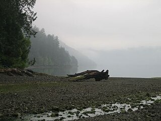
Bamberton Provincial Park is a provincial park located in Mill Bay, British Columbia, Canada. The park area consists of a beach that borders on Saanich Inlet, and is connected to a camping area by several trails. The traditional name of the beach is qʷələs in the Saanich dialect. It shares its name with the now abandoned company town of Bamberton.
Graystokes Provincial Park is a provincial park located on the border between the regional districts of Central Okanagan and North Okanagan in south-central British Columbia. It was established on 18 April 2001 to protect a large area of the ecologically diverse Okanagan Highland east of the Okanagan Valley.
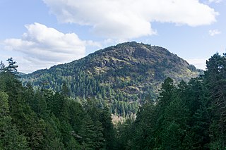
ȽÁU,WELṈEW̱/John Dean Provincial Park, formerly John Dean Provincial Park, is a small, densely vegetated provincial park on the Saanich Peninsula of southern Vancouver Island, British Columbia, Canada. The park is located on and around ȽÁU,WELṈEW̱, a small mountain in the traditional territory of Wsanec First Nations, itself situated 20 km north of Victoria, the provincial capital city.

Myra-Bellevue Provincial Park is a provincial park in British Columbia, Canada, located in the Okanagan Highland east of Kelowna. It was established to protect the full elevational range of the North Okanagan Basin and North Okanagan Highlands ecosections.
Saanich Peninsula is located north of Victoria, British Columbia, Canada. It is bounded by Saanich Inlet on the west, Satellite Channel on the north, the small Colburne Passage on the northeast, and Haro Strait on the east. The exact southern boundary of what is referred to as the "Saanich Peninsula" is somewhat fluid in local parlance.
Bamberton is an industrial site located on the Saanich Inlet, just south of Mill Bay, around 45k kilometres north of Victoria on Vancouver Island.

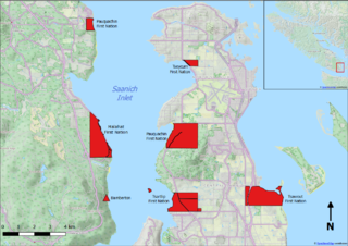
Saanich Inlet is a body of salt water that lies between the Saanich Peninsula and the Malahat highlands of Vancouver Island, British Columbia, Canada. Located just northwest of Victoria, the inlet is 25 km (16 mi) long, has a surface area of 67 km2 (26 sq mi), and its maximum depth is 226 m (741 ft). It extends from Satellite Channel in the north to Squally Reach and Finlayson Arm in the south. The only major tributary feeding the inlet is the Goldstream River.

The Vancouver Island Ranges, formerly called the Vancouver Island Mountains, are a series of mountain ranges extending along the length of Vancouver Island which has an area of 31,788 km2 (12,273 sq mi). The Vancouver Island Ranges comprise the central and largest part of the island. The Geological Survey of Canada refers to Vancouver Island, Haida Gwaii, and the Alaska Panhandle as the Insular Belt including the sea floor out to 100 km (62 mi) west of Vancouver Island. The Vancouver Island Ranges are a sub-range of the Insular Mountains.
The Insular Mountains are a range of mountains in the Pacific Coast Ranges on the Coast of British Columbia, Canada, comprising the Vancouver Island Ranges and Queen Charlotte Mountains. The Insular Mountains are rugged, particularly on Vancouver Island where peaks in Strathcona Provincial Park rise to elevations of more than 2,000 m (6,562 ft). The highest of these mountains is Golden Hinde on Vancouver Island, which rises to 2,196.818 m (7,207 ft).
McKenzie Bight is a feature on the southeast side of Saanich Inlet in British Columbia, Canada. This bight is located in Gowlland Tod Provincial Park directly adjacent to the rural community of Willis Point. McKenzie Bight can be accessed by trail from the Mount Work parking area and trailhead on Ross-Durrance road, or via a short hike from the southern end of Mark Lane in Willis Point. Nearby is a reef which is a popular shore-dive location for scuba diving.
Mount Finlayson is a 419-metre (1,375 ft) mountain located on the border of Highlands and Langford, British Columbia, about 14 km northwest of Victoria. It is located within the Gowlland Range. It is bordered by Goldstream Provincial Park and Gowlland Tod Provincial Park and forms an imposing feature looming above Saanich Inlet for those travelling south on the Malahat Drive portion of Highway 1. A steep trail leading up to the summit is easily accessible from Goldstream Park. There are also trails that link up to the summit from Bear Mountain.
Mount Work is a 449 m (1,473 ft) mountain in the Gowlland Range on southern Vancouver Island. It is located within Mount Work Regional Park in the District of Highlands, near Gowlland Tod Provincial Park and Goldstream Provincial Park, 14 km (9 mi) northwest of Victoria.

The Sea to Sea Green Blue Belt is a 62 kilometre long greenbelt surrounding the Greater Victoria metropolitan area in Canada. The greenbelt includes green space, forests, farms, and wetlands stretching from Sooke to Salt Spring Island. It also includes the "blue spaces" of Sooke Basin and Saanich Inlet.

Willis Point is a small, rural community in the Canadian province of British Columbia, located in the Juan de Fuca Electoral Area within the Capital Regional District and Greater Victoria. It is located on the Saanich Peninsula and faces north toward the Saanich Inlet. The community is bounded by the District of Highlands to the south, the District of Saanich to the southeast and the District of Central Saanich to the east. It is located west of the village of Brentwood Bay and north of the city of Victoria.


