Savona is a small community located at the west end of Kamloops Lake, where the Thompson River exits it. It is approximately halfway between Kamloops and Cache Creek along the Trans-Canada Highway. The countryside surrounding the community is semi-arid grasslands and hills, which support cattle ranching and agriculture. It has about 2000 hours of sunshine and less than 12 inches of precipitation a year. It has a population of approximately 650.

The Thompson–Nicola Regional District is a regional district in the Canadian province of British Columbia. The Canada 2021 Census population was 143,680 and the area covers 44,449.49 square kilometres. The administrative offices are in the main population centre of Kamloops, which accounts for 78 percent of the regional district's population. The only other city is Merritt; other municipally-incorporated communities include the District Municipalities of Logan Lake, Barriere and Clearwater and the Villages of Chase, Ashcroft, Cache Creek, Clinton and Lytton, and also the Mountain Resort Municipality of Sun Peaks.

Northern Manitoba is a geographic and cultural region of the Canadian province of Manitoba. Originally encompassing a small square around the Red River Colony, the province was extended north to the 60th parallel in 1912. The region's specific boundaries vary, as "northern" communities are considered to share certain social and geographic characteristics, regardless of latitude.
Bonaparte Provincial Park is an 11,811 hectare provincial park in British Columbia, Canada. It is located within the Bonaparte Plateau.

Canim Beach Provincial Park is a provincial park in British Columbia, Canada, located at the southwest end of Canim Lake in the Interlakes District of the South Cariboo region, adjacent to the Secwepemc Indian reserve community of Canim Lake, British Columbia just northeast of 100 Mile House. The park was established by Order-in-Council in 1956 and expanded by later legislation in 2000 and 2004 to total a current approximate of 8.2 hectares, 3.6 hectares of upland and 4.6 hectares of foreshore.
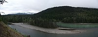
Chu Chua Cottonwood Provincial Park is a provincial park in British Columbia, Canada, located 80km north of Kamloops and incorporating a group of forested islands in the floodplain of the North Thompson River.
Eakin Creek Floodplain Provincial Park is a provincial park in British Columbia, Canada located on the North Thompson River near the community of Little Fort.
Eakin Creek Canyon Provincial Park is a provincial park in British Columbia, Canada, located on the west side of the North Thompson River near the community of Little Fort. The park is approximately 10 ha. in size.
Finn Creek Provincial Park is a provincial park in British Columbia, Canada, north of Avola and Blue River in the valley of the North Thompson River.
Greenstone Mountain Provincial Park is a provincial park in British Columbia, Canada, located south of Kamloops Lake on the northern edge of the Thompson Plateau.
North Thompson Islands Provincial Park is a provincial park in British Columbia, Canada.
Pennask Lake Provincial Park is a provincial park in British Columbia, Canada, located on the easternmost heights of the Thompson Plateau,50 km (31 mi) to the northwest of the Okanagan town of Peachland.
Porcupine Meadows Provincial Park is a 2,704 hectare provincial park in British Columbia, Canada, located north of Tranquille Lake to the northwest of Kamloops. Its name is a direct translation of the Shuswap word for this area, "pisitsoolsia", named so for the numerous porcupine in the area.
Pyramid Creek Falls Provincial Park is a provincial park in British Columbia, Canada, located on the east side of the North Thompson River between the towns of Blue River (S) and Valemount (N).
Schoolhouse Lake Provincial Park, formerly known as Lang Lake Provincial Park, is a provincial park in British Columbia, Canada.
Tsintsunko Lakes Provincial Park is a 333-hectare provincial park in British Columbia, Canada, located south of the Deadman River between Kamloops (SE) and Bonaparte Lake (NW). It is located on the Bonaparte Plateau. It was established April 30, 1996.
Tunkwa Provincial Park is a provincial park in British Columbia, Canada, located on the northern Thompson Plateau between the towns of Logan Lake (S) and Savona (N).

The Deadman River, also known as the Deadman's River, Deadman Creek or Deadman's Creek, is a tributary of the Thompson River in the British Columbia Interior of British Columbia, Canada. It is about 70 kilometres (43 mi) in length.

Rainbow/Q'iwentem Provincial Park is a recently established 385 hectare provincial park in the Cariboo region of British Columbia. The park was established in 2013, protecting the land between Sulphurous Lake and Deka Lake. While there are no developed trails in the park, existing routes used by locals exist connecting roads on the North Shore of Deka Lake to the North Shore of Sulphurous Lake. The park is accessible by road only from the southwest.
Donnely Lake Provincial Park is a BC Parks and former recreation site located in the Cariboo Regional District of British Columbia. The park was established in 2013. The park entirely surround Donnely Lake, directly north of Deka Lake. A single trail from the former recreation site of the same name leads between Bowers Lake Forest Service Road and the lake, providing access for camping and fishing.