Saysutshun (Newcastle Island Marine) Provincial Park, formally known as Newcastle Island Marine Provincial Park,[1] is a provincial park located on a small island off the coast of Nanaimo, British Columbia, Canada.
For thousands of years Saysutshun Island was used by the Coast Salish as a seasonal fishing site. The First Nations used temporary housing there, and annually left the island at the end of the season.
European explorers, including Spanish and British men from Hudson's Bay Company, initially assumed the island was uninhabited. They also harvested the abundant fish, establishing a herring industry for processing and export of the fish. Several herring salteries and fisheries were built on the North-western coast of the island.
Ki’et’sa’kun (a Snuneymuxw man), told the English about coal on the island. They named him Coal Tyee. Coal mining became the primary industry in Nanaimo in the late-nineteenth century. The HBC, aware of the importance of coal, named this island for Newcastle upon Tyne, an English area of coal production.[2]:189
During the mining for coal, the island's sandstone was found to be of exceptional quality and was soon quarried for other uses: construction of buildings in cities across Canada, and also other countries. Many different companies competed for leases of land for access to cut the Newcastle Island stone.
The timber industry also sought this stone to use as pulp-stones, to grind tree fibres into pulp for paper-making. While industrial uses predominated for years, the Canadian Pacific Railway envisioned the island as a tourist and resort destination. After a decrease in popularity with competition from other sites and a decline in train passenger travel, the railroad sold the island to the city of Nanaimo. They eventually sold it to the BC Government, who adapted it as a marine park.
Before European discovery
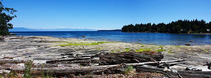
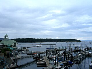
Saysutshun Island viewed from Departure Bay Beach, Nanaimo
The Snuneymuxw, the Nanaimo branch of the Coast Salish linguistic group, had two villages located on Saysutshun Island. Saysetsen, located on the east side of the island facing nearby Protection Island near Midden Bay, had easy access to the herring that spawned in the Gap during late winter and early spring. To catch the herring, the Snuneymuxw traditionally used hardwood sticks inlaid with sharp whalebone teeth along one side. By striking these into the water, they could spear ten to twelve fish at a time, and quickly fill their canoes.
They lived at Saysetsen seasonally, from January to April, in order to catch the spawning herring. Later they moved to a seasonal village at Gabriola Island where they would stay until early August. They traversed the Strait of Georgia to the mouth of the Fraser River, where they stayed until the end of August in order to catch spawning sockeye and humpback salmon. Next they returned to Vancouver Island for the chum salmon run. In January they would begin the cycle again on Saysutshun Island. Clotsun, the other village, had a name meaning Protector.
The Snuneymuxw placed their deceased in trees, where birds and animals would gradually strip the bodies. In the 19th century, there was a popular belief that they had buried their dead in chests in caves on Newcastle Island.
English officials of the Hudson's Bay Company named the island Newcastle after the discovery of coal here in 1849. It was named for the noted mining town of Newcastle upon Tyne, Northumberland, England. The discovery of coal here gave the British a source on the west coast of North America for fuel for their steamships and later railroads. Mining was established at Fort Rupert in 1830, but the quality of coal at Newcastle Island was superior and superseded it.
Native chief Ki’et’sa’kun is credited with telling the English about coal in 1849–1850. He was said to have seen a blacksmith in Fort Victoria using coal in his fire. Ki’et’sa’kun told the man he knew of a site with abundant coal. Joseph McKay, a Hudson's Bay Company clerk was told, and promised to reward the chief with rum and free gun repair if he could bring proof of his claim. In April 1850, approximately fifteen months after he first spoke to the blacksmith, Ki’et’sa’kun returned with a canoe full of coal. This coal proved to be superior to the coal being mined at Fort Rupert.
The British did not establish a mine on Newcastle Island until 1852. When the first mine was sunk there, workers produced 50 tons of coal in one day. In honour of Ki’et’sa’kun's find, the English called him 'Coal Tyee', meaning Great Coal Chief. McKay Point was named for Joseph McKay.
The two mines on Newcastle Island were called the Fitzwilliam and the Newcastle mines. The Newcastle Mine was open from 1853 to 1856 and was along the Newcastle seam. The Fitzwilliam Mine, located along the Douglas seam, was worked from 1872 to 1882. Both seams ran across the island and to Nanaimo. Coal was also found in a seam that extended to Protection Island.
In the month of September 1852 alone, 480 barrels of coal collected from surface seams were shipped from Newcastle Island to Victoria; that year's total production was 200 tons. At the beginning, native Snuneymuxw and European (mostly British) miners from Fort Rupert worked the mines but, by 1854, miners were recruited from England. They lived in Nanaimo with their families, and worked 14-day shifts in camps on Newcastle Island.
In 1862, the Hudson's Bay Company sold their coalfields, including Newcastle Island, to the Vancouver Coal Mining and Land Company. This was shortly before workers struck over the continuing poor conditions of the Nanaimo and Newcastle Island mines. There were no routine safety checks of the mines and workers believed that unskilled labour endangered all the men. The new Vancouver company discriminated against First Nations and Chinese people in wages: pay for white persons ranged from $1.75 – $3.75/day (many may have had skilled experience in mining), Natives were paid $1.25 – $1.50/day, and Chinese $1.12/day.
Accidents occurred with fatalities among workers. Worker William Beck died in a mine collapse on June 10, 1874. A gas explosion in the Fitzwilliam Mine on September 15, 1876, resulted in the deaths of three men. This was first Nanaimo mine to have fatalities from explosion.
Mine tunnels were constructed beneath the Gap from Newcastle Island to Protection Island, and from Protection Island to Gabriola Island. Miners were said to be able to tell time by distinguishing the sounds of different steamships, whose passage sounded in the mine walls.
Sandstone industry
Sandstone quarrying began on Newcastle Island in 1869 when Joseph Emery from the United States Mint in San Francisco went looking for good quality sandstone for their new building. Finding the stone on Newcastle to be of the desired quality, he signed a five-year lease with the Vancouver Coal Mining and Land Company to cut stone for the building. It was an appealing white-grey colour; it was easy to remove large blocks because its joints and fractures were few and far between; and it was strong and held up well against weathering because of unusually numerous quartz grains.
The first shipment to San Francisco occurred in the mid-1870s and continued throughout the five years to make the grand total 8000 tons of sandstone removed from Newcastle Island. This stone was used for the building's six columns along the front. They are 27feet 6inches (8.38m) long and 3feet 10inches (1.17m) in diameter. The San Francisco Mint has survived two major earthquakes. The San Francisco Mint is no longer in use as an office building and is designated as a National Historic Landmark and museum.
The U.S. Mint was planned to have eight columns, but two were lost in a shipwreck. A three-masted barque built in Medford, Massachusetts in 1855, the Zephyr arrived at Newcastle Island on January 31, 1872, to transport two of the eight sandstone pillars to San Francisco for the new building. It left Departure Bay at 10:00a.m. on February 12 in stormy weather. The following Monday at 3:30 in the morning, it hit bottom at Mayne Island. Captain Hepson and mate James Stewart drowned but the rest of the crew made it ashore safely. The Zephyr is commemorated on Newcastle Island with an exhibit about the ship that includes one of the sandstone columns recovered from the wrecked Zephyr.
The BC Penitentiary was also built of Newcastle sandstone (1877)
Many other companies sought leases on the island to cut its sandstone. This was used until 1932 for structures such as the BC Penitentiary, Nanaimo Post Office, Nanaimo Court House, the Bank of Montreal, the British North American Bank of Vancouver, St. John's Church in Victoria, and Odd Fellows Hall in Victoria.
Pulp-stone quarrying
The immense forestry industry on the west coast processed timber in numerous mills, including some to produce paper and pulp. Pulp-stones were used to grind the woodchips into pulp. In 1923, the McDonald Cut-Stone Company was founded to profit from the pulp-stone industry. To cut the stone they would first use plaster of Paris to level the cutting area, then use the cutting machines that would rotate slowly to cut a 40" deep, 54" diameter stone in just 45 minutes. After the circular cut had been made, small charges of gunpowder would be placed in holes drilled at the base of the stone to break it free. A derrick would lift the free stone before the final cuts were made, and a lathe could complete the smoothing process. The finished product would be 18–20" high with a 48" diameter.
This was a successful business on Newcastle Island until 1932. At that time the company moved operations to Gabriola Island. Later in the 20th century, the industry converted to the use of artificial stones. These could be made relatively cheaply and would last four to five years, in contrast to the three to twenty month-use period of sandstone.
Herring salteries
In the early 20th century, the influence of Asian immigrants, the majority being Japanese, and their salteries off the coast of Nanaimo was already well established. The major buyers for the salted herring and salmon were from Japan, Hong Kong, and China. Herring season went from December to February every year, but in the 1920s, the season was extended to include September, November, and October. The salmon season began in July and went until mid-August, which worked out well for the saltery owners because they could use the same facilities for both herring and salmon seeing as they could only be caught at different times of the year.
In order to catch the herring, the Japanese had a way of fishing called seining. Seining involved the use of two identical sister ships, one strengthened on the port side and the other on the starboard. They would then surround the school of herring with a net and then close it up.
On July 12, 1912, four of the salteries on Newcastle Island burnt down, totalling over $21,000 worth of damage. The salteries were owned by Mr. Oburi, Mr. Mase, Mr. Shinobu, and Mr. Makino, all of whom were issei (first generation Japanese-Canadians). The salteries were quickly rebuilt, but the cause of the fires was unknown and arson was suspected.
In 1918, T. Matsuyama and the Ode brothers got together and started the Nanaimo Shipyards Limited. Nanaimo Shipyards Limited was a shipbuilding and repair shop located on Newcastle Island. The company gained popularity and was growing rapidly. In 1939, the main shed was 24 by 24ft (7.3 by 7.3m) and by 1941, the company owned 16 boars and 4.18 acres (17,000 m2) of the island. All this was taken from them in 1941, at the start of World War II, along with Mr. Tanaka's and Mr. Kasho's salteries, when the Japanese-Canadians were sent to the Interior of British Columbia to be placed in internment camps.
In the mid-nineteenth century Hawaiian immigrant labourers, known as Kanakas, worked for the Hudson's Bay Company and the North West Company on a term-basis. Once their term was completed they were free to go wherever they pleased. Many returned home to Hawaii (then known as the Sandwich Islands), but others stayed in British Columbia. Peter Kakua was one of the many Hawaiians who married and settled in BC, having children and starting a family.
Kakua started working for the Hudson's Bay Company in 1853 and served in Fort Victoria under Governor James Douglas. After he left his position in the HBC, he moved to Nanaimo, There he met and married his wife, Que-en, also known as Mary, who was of aboriginal descent. They had a daughter in 1868.
On December 7, 1868, Kakua pleaded guilty to murder. He confessed that Que-en had decided to leave him and take their daughter, so he went drinking. After returning home the night of December 3, he found her and her parents, mother Sqush-e-lek and father Shil-at-ti-nord, packing her belongings. He left the house again, but when he returned at two in the morning, he found his father-in-law in bed with Que-en. In a fit of rage, Kakua killed everyone in the house with an axe, including his daughter. Realising what he had done, he went to see his friend Stephany. Kakua said that he needed to escape to the mainland. Stephany was also drunk and did not want to go that far. He helped Kakua row a boat to what is now Kanaka Bay on Newcastle Island.
There he was found and captured on December 4. He tried to escape custody on the boat ride back to Nanaimo but he was hit by a paddle and recaptured.
Kakua was tried by Joseph Needham, known as "the hanging judge", on February 10, 1869. The judge concluded the trial that day, saying, "Peter Kakua we find you guilty as charged of four counts of murder and sentence you to be hanged by the neck until dead". He was hanged on Friday, March 10, 1869, at Gallows Point on Protection Island, across the Gap from Newcastle. His body was buried in an unmarked grave near Kanaka Bay because both the Native people and Europeans rejected his being buried in their sacred areas.
On October 4, 1899, a body was dug up close to Kanaka Bay. It was believed to be that of PeterP Kakua. He was reburied nearby.
CPR resort
The Canadian Pacific Railway (CPR), owned and operated the British Columbia Coast Steamship Service (BCCSS). Their Princess steamships travelled the inland waters and competed with the Union Steamship Company of British Columbia for business. The Union Steamship Co bought 1,000 acres (4.0km2) of land on Bowen Island to develop as a recreational day-trio destination for people of Vancouver. As it was a great success, and the BCCSS began to seek property it could develop. They began looking for possible locations on the islands around Nanaimo, such as Taylor Bay on Gabriola Island, but decided on Newcastle Island.
In 1930, the BCCSS bought Newcastle Island from the Western Fuel Corporation of Canada for $30,000. They invested another $100,000 developing the facilities they wanted. The main attraction was the pavilion. It had a soda fountain and a spring-loaded dance floor. They also built picnic shelters and a bathhouse. They introduced muskrats and beavers to the island for the tourists to watch. By spending $50,000, they built a dock in Mark Bay for their "floating hotels".
The retired steamship, the Charmer, made its 3000th voyage in 1902. It was used as an automobile ferry from Vancouver to Nanaimo until the Princess Elaine took over. It was the first ship used on Newcastle Island as a hotel, and the first ship in British Columbia to have electric lights. People could stay there for a week for $7.50. Other boats, such as the Princess Elizabeth, the Princess Joan, and the Princess Victoria transported people there and back at a cost of $1.35 round trip. The Princess Victoria could make the Vancouver–Nanaimo voyage in 2 hours 19 minutes, which is not much slower than the current BC Ferries' runs. The Princess Victoria was also eventually used as a floating hotel.
The CPR resort on Newcastle Island was a success. It officially opened on Saturday, July 20, 1931. In that first season, some 14,323 visitors went to the island, spending a total of $21,762.35. It was not uncommon to see 1500 picnickers on the island at one time. At the start of World War II, the Princess ships were reassigned for military use and tourists could no longer visit the island.
The Newcastle Island pavilion is the only pavilion of its kind that has survived from the island resort era between the two world wars. It was restored in 1984 and can still be enjoyed today.
Nanaimo Ownership and Selling to the Provincial Government
When the CPR decided that the resort was not making enough money, they asked the City of Nanaimo whether or not they would like to buy the island. The deal went through in 1955 and the island was sold for $150,000. The City of Nanaimo had a hard time maintaining the island and they fell into debt. On December 17, 1959, a referendum was put to the people about selling the island to the Provincial Department of Recreation and Conservation for development as a Provincial Park. Voters responded with 86.8% 'yes' votes.
The B.C. government agreed to purchase the property with these six conditions:
The island would become a marine park and, if it or any part of it stopped being a marine park, it shall "revert to the Corporation of the City of Nanaimo".
The government would take possession of the island and its facilities, and the responsibilities that go with the possession as of April 1, 1960.
That access by bridge would be provided as soon as possible. Until that time access would be maintained and be equal to or greater than that provided by the City of Nanaimo in 1959.
The government must prepare a master plan for Newcastle Island's development. The City of Nanaimo would get to see this master plan and approve it before it was carried out.
Until the master plan is finished, the facilities must be maintained and operated at a level that is equal to or greater than that provided by the City of Nanaimo.
That the development of Newcastle Island into a marine park would happen as soon as possible and that preliminary development would begin in 1960.
These conditions were agreed upon on October 30, 1959. The park would be sold to the government for $1 plus the mortgage on April 1, 1960.
Development began that year to make Newcastle Island into a class A provincial park. Earle C. Westwood, Minister of Recreation and Conservation, said that Newcastle Island would be the "gem of Vancouver Island" and the "Stanley Park of Vancouver Island". Although the government did try to fulfill all their agreements, correspondence between the Minister of Recreation and Conservation and Nanaimo Alderman R. A. Brookbank show that the master plan, outlined in both points 4 and 5, had not been created. Later, after the park had been assigned to the Department of Lands, Parks and Housing rather than the Ministry of Recreation and Conservation, Brookbank continued to send letters of inquiry about the master place to the Deputy Minister Chris Grey. He responded that the plan would take a year to develop, but that had been the answer 20 years before. It is unknown whether a master plan was ever devised by the BC government.
In May 1983, the City of Nanaimo Ad Hoc Committee made their own plan. Their goals were "to provide the people of BC and particularly the Nanaimo area, a range of year-round recreation, historic, and natural history opportunities" and "to protect and develop the ability of the natural and cultural resources of the park to provide such opportunities in perpetuity." Many of this committee's ideas and suggestions were carried out, but some were not. There has never been sport fishing on Mallard Lake and there has never been a designated volleyball area. The committee also addressed the issue of the bridge. They felt that a bridge would not meet the park's objectives and would generally be a bad idea.
In 2021, the parks was renamed as Saysutshun (Newcastle Island Marine) Park to acknowledge its first inhabitants, the Snuneymuxw people.[3]
Current uses
Currently, no one except park authorities live on Newcastle Island. The original First Nations peoples who inhabited the island left in 1849 when the Hudson's Bay Company started opening up coal mines. The park has become an extremely popular tourist spot that now caters to hikers, campers, bird watchers, and kayakers alike.
Walk in campsites are available on a first-come, first-served basis. Mooring buoys are available (no reservations), but many boating visitors simply anchor in the area between Newcastle Island and Protection Island. An exceptionally lucky visitor might find space at the dock to tie up. A fee is charged for camping, mooring to a buoy, and overnight use of the dock.
Transportation
Newcastle Island (Saysutshun) is accessible only by water. A foot-passenger ferry crosses in ten minutes from downtown Nanaimo at Maffeo Sutton Park to the southern end of the island. It is also a popular destination for kayakers and other boaters. In the summer at low tide, you can walk across the narrow straits separating it from Protection Island.
Mallard Lake
Since Newcastle Island was originally a resourced-based commercial island with a population of people living there, they needed a water supply. Mallard Lake, near the centre of the island, is an artificial lake created to serve as a reservoir. It now is the center of a wildlife sanctuary. Bird watching is one of the most popular activities on the island, and Mallard Lake is a prime place for that.
Panorama image
Newcastle Island looking towards the Georgia Strait/Salish sea, with lower mainland coastal mountains in the background
Vancouver Island is an island in the northeastern Pacific Ocean and part of the Canadian province of British Columbia. The island is 456 km (283 mi) in length, 100 km (62 mi) in width at its widest point, and 32,100 km2 (12,400 sq mi) in total area, while 31,285 km2 (12,079 sq mi) are of land. The island is the largest by area and the most populous along the west coasts of the Americas.
British Columbia Ferry Services Inc., operating as BC Ferries (BCF), is a former provincial Crown corporation, now operating as an independently managed, publicly owned Canadian company. BC Ferries provides all major passenger and vehicle ferry services for coastal and island communities in the Canadian province of British Columbia. Set up in 1960 to provide a similar service to that provided by the Black Ball Line and the Canadian Pacific Railway, which were affected by job action at the time, BC Ferries has become the largest passenger ferry line in North America, operating a fleet of 36 vessels with a total passenger and crew capacity of over 27,000, serving 47 locations on the B.C. coast.
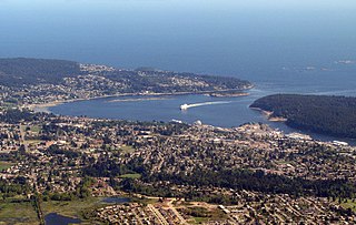
Nanaimo is a city on the east coast of Vancouver Island, in British Columbia, Canada. As of the 2021 census, it had a population of 99,863, and it is known as "The Harbour City." The city was previously known as the "Hub City," which was attributed to its original layout design, whose streets radiated from the shoreline like the spokes of a wagon wheel, and to its central location on Vancouver Island. Nanaimo is the headquarters of the Regional District of Nanaimo.
The Island Rail Corridor, previously the Esquimalt & Nanaimo Railway, is a railway operation on Vancouver Island and is the only remaining railway on Vancouver Island after the closure of the Englewood Railway in November 2017. The Island Corridor Foundation owns the former Esquimalt & Nanaimo Railway corridor. The railway line is 225 kilometres (140 mi) in length from Victoria to Courtenay, known as the Victoria Subdivision, with a branch line from Parksville to Port Alberni known as the Port Alberni Subdivision at 64 kilometres (40 mi) in length, for a total 289 kilometres (180 mi) of mainline track. In 2006, the Island Corridor Foundation acquired the railway's ownership from the Canadian Pacific Railway.
The Snuneymuxw First Nation is located in and around the city of Nanaimo on east-central Vancouver Island, British Columbia, Canada. The nation previously had also occupied territory along the Fraser River, in British Columbia.
Gabriola Island is one of the Gulf Islands in the Strait of Georgia in British Columbia (BC), Canada. It is about 5 kilometres (3.1 mi) east of Nanaimo on Vancouver Island, to which it is linked by a 20-minute ferry service. It has a land area of about 57.6 square kilometres (22.2 sq mi) and a resident population of 4,500.
Robert Dunsmuir was a Scottish-Canadian coal mine developer, owner and operator, railway developer, industrialist and politician in British Columbia.
Departure Bay is a bay in central Nanaimo, British Columbia, on the east coast of Vancouver Island. The surrounding neighbourhood is also referred to as "Departure Bay" —once a settlement of its own, it was amalgamated into the City of Nanaimo in the 1970s.
Sandwell Provincial Park is a provincial park in British Columbia, Canada.
Cedar is a small community in the Canadian province of British Columbia. It is located near the east coast of Vancouver Island — about 8 kilometres (5.0 mi) south-east of Nanaimo — along the banks of the Nanaimo River. Its geographical coordinates are 49°07′N123°51′W.
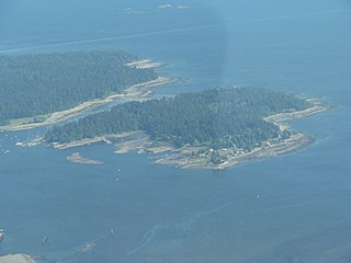
Protection Island is a small island located 1.5 km north-east of downtown Nanaimo, British Columbia, Canada in the Nanaimo Harbour. The island was originally named Douglas Island, after James Douglas the first Governor of the Colony of Vancouver Island and British Columbia. It was renamed Protection Island in 1960. The permanent year-round population is about 350 people.
Wellington, formerly a separate district and town, is a neighbourhood of north Nanaimo, on the east coast of southern Vancouver Island, British Columbia.
Asbury Park was a high-speed coastal steamer built in Philadelphia, and intended to transport well-to-do persons from New York to summer homes on the New Jersey shore. This vessel was sold to West Coast interests in 1918, and later converted to an automobile ferry, serving on various routes San Francisco Bay, Puget Sound and British Columbia. This vessel was known by a number of other names, including City of Sacramento, Kahloke, Langdale Queen, and Lady Grace.
The Union Steamship Company of British Columbia was a pioneer firm on coastal British Columbia. It was founded in November 1889 by John Darling, a director of the Union Steamship Company of New Zealand, and nine local businessmen. The company began by offering local service on Burrard Inlet near Vancouver and later expanded to servicing the entire British Columbia coast.
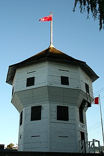
The Nanaimo Bastion is a historical octagon-shaped blockhouse located at 98 Front Street in Nanaimo, British Columbia, Canada. The Hudson's Bay Company, which then held a royal lease on all of what was then the Colony of Vancouver Island, built it between 1853 and 1855 to defend its coal mining operations in Nanaimo. It has been called "Nanaimo's premier landmark", because of its shape and its high visibility from both land and sea.
Cowichan was a steamship which was operated in British Columbia under the ownership of the Union Steamship Company. Cowichan sank in 1925 following a collision with another ship.
The Nanaimo River is a river on Vancouver Island, British Columbia, Canada, located near the city of Nanaimo on the island's east coast. Its headwaters are in the Vancouver Island Ranges of central Vancouver Island and its mouth, the Nanaimo River estuary, is at the south end of Nanaimo Harbour in the Strait of Georgia. The estuary is part of the Pacific Estuary Conservation Program.
Nanaimo Harbour, also known as the Port of Nanaimo, is a natural harbour on the east coast of Vancouver Island, British Columbia, Canada. The City of Nanaimo runs along the west side of the harbour. Three islands, Newcastle, Protection, and Gabriola, along with Duke Point, form the eastern edge. The Port of Nanaimo includes the Inner Harbour, Nanaimo River estuary, Departure Bay, the waters on the east side of Newcastle and Protection Islands, and Northumberland Channel. The port is under the management of the Nanaimo Port Authority.
Chase River, known in the Hulquminum language as Kulwulton, is a river on Vancouver Island, British Columbia, Canada, discharging into the Strait of Georgia at the south end of Nanaimo Harbour. It is the namesake of the city of Nanaimo's neighbourhood of Chase River.
Blier, Richard K. (ed.) (2000). Hiking Trails II: South-Central Vancouver Island and the Gulf Islands (8thed.). Vancouver: Vancouver Island Trails Information Society. ISBN0-9697667-3-4.{{cite book}}: |first= has generic name (help)
Douglass, Don; Réanne Hemingway-Douglass (1998). Exploring the San Juan and Gulf Islands: Cruising Paradise of the Pacific Northwest. Bishop, California: Fine Edge Productions. pp.303–306. ISBN0-938665-51-0.
Farley, A. L. (1979). Atlas of British Columbia: People, Environment, and Resource Use. University of British Columbia Press: Vancouver.
Gazetteer of Canada: British Columbia (3rded.). Ottawa: Canadian Permanent Committee on Geographical Names. 1985.
Ghosts of Newcastle Island. Nanaimo Visitor Information Centre.
Hacking, Norman R.; W. Kaye Lamb (1974). The Princess Story: A Century and a Half of West Coast Shipping. Vancouver: Mitchell Press. p.279.
Merilees, Bill (1998). Newcastle Island: A Place of Discovery. Surrey, B.C.: Heritage House. pp.1–128. ISBN1-895811-58-9.
Ministry of water, land and air protection. 3 April 2002 @ .
Nanaimo District Museum
Nanaimo Now. 3 April 2002 @ .
"Newcastle has interesting history". (1990, June 18). The Bulletin.
"Newcastle has withstood test of time". (1990, June 25). The Bulletin.
Newcastle Island. 3 April 2002 @ .
Newcastle Island Provincial Park. 3 April 2002 @ .
Shinnick, John, ed. (2005). BC Marine Parks Guide: The Official Guide to BC's Coastal Marine Parks (2nded.). Vancouver: Op Publishing. p.48. ISBN1-896373-72-0.
Stone, Ted (1998). British Columbia History Along the Highways & Waterways: A Traveler's Guide to the Fascinating Facts, Intriguing Incidents and Lively Legends of Vancouver Island & the British Columbia Coast. Red Deer, Alberta: Red Deer College Press. pp.100–101. ISBN0-88995-173-X.
Twenty-Five Years of Newcastle Island. Nanaimo Visitor Information Centre.
This page is based on this Wikipedia article Text is available under the CC BY-SA 4.0 license; additional terms may apply. Images, videos and audio are available under their respective licenses.