Comox is a town on the southern coast of the Comox Peninsula in the Strait of Georgia on the eastern coast of Vancouver Island, British Columbia. Thousands of years ago, the warm dry summers, mild winters, fertile soil, and abundant sea life attracted First Nations, who called the area kw'umuxws.

The Kʼómoks or Kʼomoks, usually known in English as the Comox, are an Indigenous group of Coast Salishan-speaking people in Comox, British Columbia and in Toba Inlet and the Malaspina Peninsula areas of the British Columbia mainland across Georgia Strait. They historically spoke the Komox language (Comox-Sliammon), and were divided in two main dialect and tribal groupings, which are known by academics as Island Comox and Mainland Comox.

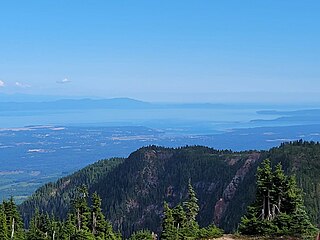
The Strait of Georgia or the Georgia Strait is an arm of the Salish Sea between Vancouver Island and the extreme southwestern mainland coast of British Columbia, Canada, and the extreme northwestern mainland coast of Washington, United States. It is approximately 240 kilometres (150 mi) long and varies in width from 20 to 58 kilometres. Along with the Strait of Juan de Fuca and Puget Sound, it is a constituent part of the Salish Sea.

Courtenay is a city of about 26,000 on the east coast of Vancouver Island, in the Canadian province of British Columbia. It is the largest community and only city in the area commonly known as the Comox Valley, and the seat of the Comox Valley Regional District, which replaced the Comox-Strathcona Regional District. Courtenay is 4 km (2.5 mi) west of the town of Comox, 7 km (4.3 mi) northeast of the village of Cumberland, 5 km (3.1 mi) northwest of the unincorporated settlement of Royston, and 108 km (67 mi) northwest of Nanaimo. Along with Nanaimo and Victoria, it is home to The Canadian Scottish Regiment, a Primary Reserve infantry regiment of the Canadian Armed Forces.

Quadra Island is a large island off the eastern coast of Vancouver Island, in British Columbia, Canada. It is part of the Discovery Islands, in the Strathcona Regional District.
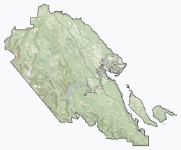
The Comox Valley is a region on the east coast of Vancouver Island, British Columbia, Canada, that includes the city of Courtenay, the town of Comox, the village of Cumberland, and the unincorporated settlements of Royston, Union Bay, Fanny Bay, Black Creek, and Merville. The communities of Denman Island and Hornby Island are also considered part of the Comox Valley. The Comox Valley contains the 47th largest metropolitan area in Canada with a population of about 76,000 as of 2022.
Hornby Island of British Columbia, Canada, is one of the two northernmost Gulf Islands, the other being Denman Island. It is located near Vancouver Island's Comox Valley,
Union Bay is an unincorporated community located south of Hart Creek on the east coast of central Vancouver Island, British Columbia. This Comox Valley community on BC Highway 19A is by road about 93 kilometres (58 mi) north of Nanaimo, and 14 kilometres (9 mi) south of Courtenay.
Baynes Sound is the channel between Denman Island and Vancouver Island, British Columbia, Canada. The sound is a narrow western offshoot of the Strait of Georgia that separates Vancouver Island from the mainland of British Columbia. The area is actively harvested by the local oyster industry, as is apparent by an abundance of oyster farms. It produces 39% of the oysters and 55% of the manila clams farmed in British Columbia. The sound is 40 km (25 mi) long and is 3.5 km (2.2 mi) wide at its widest point, although the average width is less than 2 km (1.2 mi). The southern boundary lies around Chrome Island, a small island off Boyle Point, the southern tip of Denman. The northern boundary is less defined, but lies between Tree Island at the northern end of Denman and the Comox harbour. The sound is dotted with the small communities of Royston, Union Bay, Buckley Bay, Mud Bay, Fanny Bay, and Deep Bay on Vancouver Island. The crossing is served by the British Columbia Ferry Services Inc. ship MV Baynes Sound Connector, between Buckley Bay and Denman Island. Baynes Sound is named after British Rear Admiral Robert L. Baynes, who commanded the Pacific Squadron from 1857 to 1860. Baynes Sound is the home of Vancouver Island University Center for Shellfish Research's Deep Bay Marine Field Station.

The Pentlatch, Pentl’ach, Puntlatch, Puntlatsh or Puntledge language is a Salishan language that was spoken on Canada's Vancouver Island in a small area between Comox and Nanaimo, British Columbia. The Pentlatch people formerly numbered at least 3,000 with at least 90 settlements in the area. The language became extinct after the death of the last fluent speaker Joe Nim Nim in 1940, but researchers from Qualicum First Nation declared it to be a living language in December 2023.

Miracle Beach Provincial Park is a provincial park on the eastern shore of Vancouver Island in British Columbia, Canada. Located between Comox and Campbell River, the park includes a foreshore area in the Strait of Georgia, much of the Black Creek estuary, and a forested area. According to its Master Plan, it fulfills primarily a recreational role with a focus on beach play, picnicking, nature appreciation, and camping, and a secondary conservation role with a focus on the natural shoreline and estuary. In support of its recreational focus the park is developed with a day-use parking area with accessible trails leading to the shoreline and a camping area with 200 drive-in sites. The park is also hosts a nature centre building and a sheltered group picnic shelter. Vegetation in the park is typical for the region's second-growth forests with Douglas-fir most prominent. Common associates include Western hemlock, Sitka spruce, red alder and bigleaf maple. Salal and sword fern are the most abundant shrub. Black Creek, which flows through the park, is a spawning area for coho salmon.

Bowser is a community on the east coast of Vancouver Island in British Columbia, Canada. It has a population of 1,729. Approximately 66 kilometres (41 mi) north of Nanaimo, Bowser is in a region informally known as Lighthouse Country, spanning a stretch of highway that extends from Qualicum Beach in the south to Horne Lake to the west and Fanny Bay in the north and east to Denman and Hornby Islands. Bowser is in the Regional District of Nanaimo and in its Electoral Area H, one of eight in the District. The community was named after William J. Bowser, premier of British Columbia from 1915 to 1916. Bowser is served by the coast-spanning Island Highway.
School District 71 Comox Valley is a school district on Vancouver Island in British Columbia, Canada. This includes the communities of Courtenay, Comox and Cumberland as well as the surrounding rural areas and the adjacent islands of Denman and Hornby.

Fanny Bay is an unincorporated community in the Canadian province of British Columbia. It is located on Baynes Sound on the east coast of Vancouver Island. It has a population of 921. It is best known for its fine oysters. The area is served by the Island Highway.
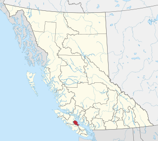
The Comox Valley Regional District is a regional district in British Columbia, Canada. It was created on February 15, 2008, encompassing the southeastern portions of the former Regional District of Comox-Strathcona, and centred about the Comox Valley. The partition left the new Comox Valley Regional District with only 8.4 percent of the former Comox-Strathcona's land area, but 57.9 percent of its population. The CVRD covers an area of 2,425 square kilometres, of which 1,725 square kilometres is land, and serves a population of 72,445 according to the 2023 Census. The district borders the Strathcona Regional District to the northwest, the Alberni-Clayoquot Regional District to the southwest, and the Regional District of Nanaimo to the southeast, as well as the qathet Regional District along the Strait of Georgia to the east.

Shawnigan Lake is a lake on southern Vancouver Island, located to the west of Saanich Inlet and to the south of the Cowichan Valley region. Its aboriginal name in the Hul'qumi'num language is Showe'luqun.

The Deep Bay Marine Field Station is a marine biological research facility operated by Vancouver Island University's Centre for Shellfish Research. It is located at Deep Bay, British Columbia on Vancouver Island, off the waters of Baynes Sound, 78 kilometres (48 mi) north-west of the main university campus at Nanaimo, British Columbia.

Baynes Sound Connector is a car ferry owned and operated by B.C. Ferries that runs between Buckley Bay on Vancouver Island and Denman Island. It is the first and only cable ferry in the BC Ferries fleet and replaced the self-propelled MV Quinitsa in February 2016. Red and green transit lights are installed at both Buckley Bay and Denman West terminals facing oncoming marine traffic in each direction. It is illegal to cross the channel while the red light is on, signifying the ferry is in transit. The crossing with a length of 1,961.48 metres (6,435.3 ft) is the longest cable ferry crossing in the world. It uses two guide cables and a third driving cable.
Beddis soil series is a coarse, well to rapidly drained soil which occurs on eastern Vancouver Island and the adjacent Gulf Islands. Its parent material is eolian, fluvial or marine sand. The soil texture is usually loamy sand or sandy loam, but pure sand horizons may also be encountered. The usual soil classification is Orthic Dystric Brunisol. A Gleyed Humo-Ferric Podzol example is also known, although that profile does not have the eluvial horizon characteristic of classic Podzol development.
Baynes soil series is an imperfectly drained soil which occurs on eastern Vancouver Island and the adjacent Gulf Islands. Its parent material is eolian, fluvial or marine sand. The soil texture is usually loamy sand or sandy loam, but pure sand horizons may also be encountered. It is classified as Gleyed Dystric Brunisol or Gleyed Humo-Ferric Podzol.