
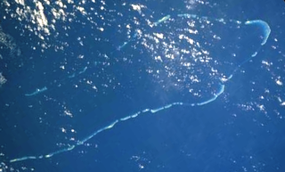
The Coral Sea Islands Territory is an external territory of Australia which comprises a group of small and mostly uninhabited tropical islands and reefs in the Coral Sea, north-east of Queensland, Australia. The only inhabited island is Willis Island. The territory covers 780,000 km2 (301,160 sq mi), most of which is ocean, extending east and south from the outer edge of the Great Barrier Reef and includes Heralds Beacon Island, Osprey Reef, the Willis Group and fifteen other reef/island groups. Cato Island is the highest point in the Territory.

The San Juan Islands is an archipelago in the Pacific Northwest of the United States between the U.S. state of Washington and Vancouver Island, British Columbia, Canada. The San Juan Islands are part of Washington state, and form the core of San Juan County.

Gulf Islands National Park Reserve is a national park located on and around the Gulf Islands in British Columbia, Canada. In the National Parks System Plan, this park provides representation of the Strait of Georgia Lowlands natural region, the only place in Canada with a Mediterranean climate of dry, sunny summers and mild, wet winters, the result of a rain shadow effect from surrounding mountains between the region and the ocean. It has similar dominant vegetation as the Pacific Northwest, such as coastal Douglas-fir, western red cedar, shore pine, Pacific dogwood, bigleaf maple, and red alder, but also contains the northern extent of some of the more drought tolerant trees such as Garry oak and Arbutus. The park was created in 2003 as the fortieth national park. It covers 36 square kilometres (14 sq mi) of area on 16 islands and more than 30 islets, reefs and surrounding waters, making it the sixth smallest national park in Canada.

The Maldives are formed by 20 natural atolls, along with a few islands and isolated reefs today which form a pattern stretching from 7 degrees 10′ North to 0 degrees 45′ South. The largest of these atolls is Boduthiladhunmathi, while the atoll containing the most islands is Huvadhu.

The Bounty Islands are a small group of uninhabited granite islets and numerous rocks, with a combined area of circa 50 ha in the South Pacific Ocean. Territorially part of New Zealand, they lie about 670 km (420 mi) east-south-east of New Zealand's South Island, 530 km (330 mi) south-west of the Chatham Islands, and 215 km (134 mi) north of the Antipodes Islands. The group is a World Heritage Site.

The Alaska Maritime National Wildlife Refuge is a United States National Wildlife Refuge comprising 2,400 islands, headlands, rocks, islets, spires and reefs in Alaska, with a total area of 4.9 million acres (20,000 km2), of which 2.64 million acres (10,700 km2) is wilderness. The refuge stretches from Cape Lisburne on the Chukchi Sea to the tip of the Aleutian Islands in the west and Forrester Island in the southern Alaska Panhandle region in the east. The refuge has diverse landforms and terrains, including tundra, rainforest, cliffs, volcanoes, beaches, lakes, and streams.
Lihou Reef National Nature Reserve is a former marine protected area covering an area of 8440 km2 in the Australian Coral Sea Islands Territory that was incorporated into the new Coral Sea Commonwealth Marine Reserve in December 2012. Together with the Coringa-Herald National Nature Reserve, from which it is separated by about 100 km of open ocean, it forms the Coral Sea Reserves Ramsar Site, designated on 16 August 2002, listing it under the Ramsar Convention as a wetland of international importance.

Kayangel (Ngcheangel) is the northernmost state of Palau 86 km (53 mi) north of Koror. The land area is about 1.4 km2 (0.54 sq mi). The population is 54. There is one hamlet in the state - Orukei which is also its capital.

Okinotorishima, or Parece Vela, is a coral reef, geologically an atoll, with two rocks enlarged with tetrapod-cement structures. It is administered by Japan with a total shoal area of 8,482 m2 and land area 9.44 m2 (101.6 sq ft). Its dry land area is mostly made up by three concrete encasings and there is a 100 by 50 m stilt platform in the lagoon housing a research station. There is a third completely artificial tetrapod-cement islet.

Algoa Bay is a maritime bay in the Eastern Cape, South Africa. It is located on the east coast, 683 kilometres (424 mi) east of the Cape of Good Hope.

Smuggler Cove Marine Provincial Park is a provincial park in British Columbia, Canada.

Scott and Seringapatam Reefs is a group of atoll-like reefs in the Timor Sea more than 300 kilometres (190 mi) northwest of Cape Leveque, Western Australia, on the edge of the continental shelf. There are three or four separate reef structures, depending on whether Scott Reef Central is counted separately.

De Courcy Island is one of the Gulf Islands of the coast of southwestern British Columbia, Canada, located between the Pylades and Stuart Channels approximately 16 km (9.9 mi) southeast of Nanaimo and approximately 38 km (24 mi) west of Vancouver.

Active Pass is a strait separating Galiano Island in the north and Mayne Island in the south in the southern Gulf Islands, British Columbia, Canada. It connects the Trincomali Channel in the west and the Strait of Georgia in the east. The pass stretches 5.5 km from northeast to southwest with two roughly right-angle bends, one at each end.
The Islets of Mauritius include circa 130 tiny islets and rocks scattered around the coast of Mauritius, Rodrigues, Agalega and St Brandon.

The Olango Island Group is a group of islands found in the Central Visayas region of the Philippines. It comprises Olango island and 6 satellite islets namely: Caubian, Camungi, Caohagan, Gilutongan, Nalusuan, Pangan-an, and Sulpa. The island group has a total land area of approximately 1,030 hectares. It is divided under the jurisdiction of the city of Lapu-Lapu and the municipality of Cordova, Cebu. It lies 5 kilometers (3.1 mi) east of Mactan and is a major tourist destination in Cebu. It is known for its wildlife sanctuary. The entire area is the first declared Ramsar Wetland Site in the Philippines, as recognized in 1994.
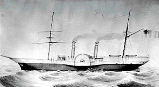
The Labouchere was a paddle steamer in the service of the Hudson's Bay Company, built in 1858 at Green's in Blackwall, London, England. Under the command of Captain J. Trivett it was mostly in service in British Columbia and the rest of the Pacific Northwest in the 1850s and 1860s, including the Stikine lisière in Russian America. In 1859, its then-captain John Swanson was elected by a "celebrated" majority of one in the colonial riding of Nanaimo for the Legislative Assembly of the Colony of Vancouver Island.
Beatrice Islets are pair of islets in the Australian state of South Australia located in Nepean Bay on the north coast of Kangaroo Island about 4 kilometres east of Kingscote. The islets and adjoining intertidal areas are notable as habitat for bird life. The islet pair has enjoyed protected area status since 1909 and since at least 1972, have been part of the Beatrice Islet Conservation Park. During either the 1960s or the 1970s, the islets were extensively damaged by an exercise to remove an infestation of South African boxthorn.

The Fox Islands Passes are waterways in the Fox Islands area of the U.S. state of Alaska, connecting the Bering Sea with the North Pacific Ocean.
Goose Island is a small, uninhabited rocky island off of the coast of Connecticut, in Long Island Sound. It belongs to the town of Guilford. It is near Falkner Island, North Rocks, Falkner Island Reef, Stony Island, and Three Quarters Rock. Goose Island has eroded to the point that it is 0.5 acre and virtually underwater at high tide, although it was once about 4 acres in size. The strait between the two islands is between 16 and 8 feet deep. The coastline is defined prominently by two small bays that connect during high tide.