British Columbia Ferry Services Inc., operating as BC Ferries (BCF), is a former provincial Crown corporation, now operating as an independently managed, publicly owned Canadian company. BC Ferries provides all major passenger and vehicle ferry services for coastal and island communities in the Canadian province of British Columbia. Set up in 1960 to provide a similar service to that provided by the Black Ball Line and the Canadian Pacific Railway, which were affected by job action at the time, BC Ferries has become the largest passenger ferry line in North America, operating a fleet of 41 vessels with a total passenger and crew capacity of over 27,000, serving 47 locations on the B.C. coast.

Burrard Inlet is a relatively shallow-sided fjord in northwestern Lower Mainland, British Columbia, Canada. Formed during the last Ice Age, it separates the City of Vancouver and the rest of the lowland Burrard Peninsula to the south from the coastal slopes of the North Shore Mountains, which span West Vancouver and the City and District of North Vancouver to the north.
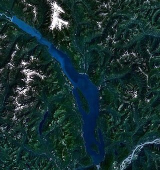
Harrison Lake is the largest lake in the southern Coast Mountains of Canada, being about 250 square kilometres (95 mi²) in area. It is about 60 km (37 mi) in length and at its widest almost 9 km (5.6 mi) across. Its southern end, at the resort community of Harrison Hot Springs, is c. 95 km east of downtown Vancouver. East of the lake are the Lillooet Ranges while to the west are the Douglas Ranges. The lake is the last of a series of large north-south glacial valleys tributary to the Fraser along its north bank east of Vancouver, British Columbia. The others to the west are the Chehalis, Stave, Alouette, Pitt, and Coquitlam Rivers.

Knight Inlet is one of the principal inlets of the British Columbia Coast, and the largest of the major inlets in the southern part of the Coast. It is fifth in sequence of the great saltwater inlets north from the 49th parallel near Vancouver, but it is the first whose outflow points away from the Strait of Georgia, opening into Queen Charlotte Strait at the Kwakwakaʼwakw community of Memkumlis on Village Island.

Vargas Island Provincial Park is a provincial park in British Columbia, Canada, comprising the west side of the island of the same name, which is located west of Meares Island and northwest of the resort community of Tofino in the Clayoquot Sound region of the West Coast of Vancouver Island, British Columbia, Canada. The park was created as part of the Clayoquot Land-Use Decision on July 13, 1995 and contains 5,805 hectares, 1,543 hectares of it being upland and 4,262 hectares being foreshore. Also located on Vargas Island, on its north side, is Epper Passage Provincial Park.
Memory Island Provincial Park is a provincial park located on Vancouver Island in British Columbia, Canada. It was established by BC Parks on 23 August 1945 to protect a small island located at the southern end of Shawnigan Lake.

The Golden Hinde is a mountain located in the Vancouver Island Ranges on Vancouver Island, British Columbia, Canada. At 2,195 metres (7,201 ft), it is the highest peak on the island. The peak is popular with experienced backcountry-climbers, having been first ascended in 1913. The mountain is made of basalt which is part of the Karmutsen Formation.

Cortes Island is an island in the Discovery Islands archipelago on the coast of British Columbia, Canada. The island is 25 km (16 mi) long, 13 km (8 mi) wide, and 130 km2 (50 sq mi) in area. It has a population of 1,035 permanent residents. Cortes Island lies within Electoral Area B of the Strathcona Regional District, which provides water and sewerage systems, fire protection, land use planning, parks, recreation, and emergency response.

Langdale is a small community on the Sunshine Coast of southern British Columbia, Canada. It is set in a verdant environment characteristic of many small BC communities. It plays host to a ferry terminal of the same name, which serves as the point of entry for most vehicles entering the Sunshine Coast region. Langdale is part of West Howe Sound, Electoral Area F within the Sunshine Coast Regional District (SCRD) in British Columbia, Canada.

Discovery Passage is a strait that forms part of the Inside Passage between Vancouver Island and the Discovery Islands of British Columbia. The strait is considered the most important natural passage for vessels' entering or leaving the Salish Sea from the north.
William Henry McNeill was best known for his 1830 expedition as the captain of the brig Llama, which sailed from Boston, Massachusetts, United States, 12,000 miles (19,000 km) around Cape Horn, to the Pacific Northwest on a maritime fur trade expedition.

Milbanke Sound is a sound on the coast of the Canadian province of British Columbia.
Passage Island is a small island near West Vancouver, British Columbia, and across from Bowen Island in Canada. The island is mostly woodland and cliffs. It marks the entrance to Howe Sound, and the ferry between Horseshoe Bay to Nanaimo regularly passes it. The island borrows a postal code, V7W 1V7, from the wealthiest community in Canada, West Vancouver. However, Passage Island is actually overseen by the Islands Trust and is part of the Metro Vancouver Regional District. It is isolated from West Vancouver by approximately two km (1.2 mi) of ocean.

Barkley Sound, also known historically as Barclay Sound, is south of Ucluelet and north of Bamfield on the west coast of Vancouver Island and forms the entrance to the Alberni Inlet. The Broken Group archipelago lies in the sound. Barkley Sound is part of the traditional territory of the Nuu-cha-nulth First Nations. In 1787, Captain Charles William Barkley of Imperial Eagle, explored the sound and named it after himself. Barkley traveled with his 17-year-old bride, Frances Barkley, the first European woman to visit what is now British Columbia.
Robson Bight is a small Vancouver Island bay at the west end of Johnstone Strait across from West Cracroft Island in British Columbia, Canada that includes a protected killer whale habitat famous for its whale-rubbing beaches. The bight is adjacent to Lower Tsitika River Provincial Park. The nearest access point is Telegraph Cove on the east coast of Northern Vancouver Island.
Vesuvius, also known as Vesuvius Bay, is an unincorporated settlement and ferry terminal on the northwest coast of Saltspring Island in the Gulf Islands of British Columbia, Canada. It is the eastern terminus of a ferry which connects Saltspring Island to Vancouver Island across Sansum Narrows to Crofton, which is just north of the city of Duncan.

The Chatham Islands are a group of islands off the east coast of Oak Bay, British Columbia, Canada. All the islands are in Chatham Islands Indian Reserve No. 4, under the control of the Songhees First Nation. The island foreshore, defined as the land between low tide and the beginning of land-based vegetation, is provincial Crown land.
Burke Channel is a channel in the Central Coast region of the Canadian province of British Columbia, separating the south and east coasts of King Island from the mainland. It was first charted in 1792 by James Johnstone, one of George Vancouver's officers during his 1791-1795 expedition. Vancouver named it "Burke's Channel" after Edmund Burke.
Fisher Channel is a channel in the Central Coast region of the Canadian province of British Columbia. To its west are Hunter and Denny Islands, to its east King Island. It was first charted in 1793 by George Vancouver during his 1791-95 expedition. He named it "Fisher’s Channel" after "a much-respected friend" Reverend John Fisher.


