Jervis Inlet is one of the principal inlets of the British Columbia Coast, about 95 km (59 mi) northwest of Vancouver, and the third of such inlets north of the 49th parallel, the first of which is Burrard Inlet, Vancouver's harbour.

Quatsino Provincial Park is a provincial park in British Columbia, Canada, located on Quatsino Sound on northern Vancouver Island.
Green Inlet Marine Provincial Park is a provincial park in British Columbia, Canada, located in the North Coast region to the southeast of Butedale and containing 33 ha.
Halkett Bay Marine Provincial Park is a provincial park off Gambier Island in British Columbia, Canada.

Harmony Islands Marine Provincial Park is a provincial park in British Columbia, Canada, located on the east side of Hotham Sound, which is a side-inlet of the lower reaches of Jervis Inlet, on that inlet's north side roughly opposite the mouth of Sechelt Inlet.
Háthayim Marine Provincial Park, formerly Von Donop Marine Provincial Park, is a provincial park in British Columbia, Canada, located on the north end of Cortes Island in the Discovery Islands.
Homathko Estuary Provincial Park is a provincial park in British Columbia, Canada, located at the head of Bute Inlet surrounding the mouth of the Homathko River in the Pacific Ranges of the Coast Mountains.

Montague Harbour Marine Provincial Park is a provincial park in British Columbia, Canada, located on Galiano Island, one of the Gulf Islands off BC's South Coast in Canada. It is accessible by BC Ferries from Swartz Bay on Vancouver Island or Tsawwassen on the Mainland. The Island's ferry terminal is at Sturdies Bay, about 6 km (3.7 mi) from Montague.

Pirates Cove Marine Provincial Park is a provincial park on De Courcy Island in British Columbia, Canada.
Sechelt Inlets Marine Provincial Park is a provincial park in British Columbia, Canada, at various locations on Sechelt Inlet, Salmon Inlet and Narrows Inlet, near Sechelt. Established initially as a recreation area in 1980, it was converted to a park in 1999, containing approximately 140 hectares.

Simson Provincial Park is a provincial park in British Columbia, Canada.
Small Inlet Marine Provincial Park is a provincial park in British Columbia, Canada on the northwest side of Quadra Island, near the city of Campbell River.

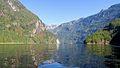
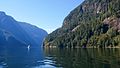
Princess Louisa Inlet is a fjord on British Columbia’s Sunshine Coast and within the swiya of the shíshálh Nation.
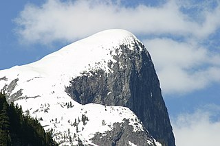
One Eye Peak is a mountain located at Princess Louisa Inlet. One Eye Peak is part of the Pacific Ranges of the Coast Mountains in southwestern British Columbia, Canada. When Thomas F. Hamilton build his resort called the Malibu Club at the entrance of Princess Louisa Inlet he named the mountain after himself - Mt. Hamilton. The mountain is typically referred to by its English title of a Sechelt First Nation translation "TUHK-OHSS" referring to "Old One Eye" and is the protector of the inlet.
Malibu is a locality in the Canadian province of British Columbia's Sunshine Coast district. This place may also be referred to as Malibu Islet and Malibu Rapids. This was the site of the Malibu Club, formerly a private resort which is today a Young Life camp.

Chatterbox Falls is a waterfall in British Columbia, Canada, located at the head or end of Princess Louisa Inlet. It is part of Loquilts River which empties into the inlet. The falls are a popular destination for boaters around the world and are in Princess Louisa Marine Provincial Park, part of BC Parks' marine park system which manages the area with the cooperation of the Princess Louisa International Society.

Portland Island is an island of the Southern Gulf Islands of the South Coast of British Columbia, Canada. It is located in the Salish Sea west of Moresby Island and off the south tip of Saltspring Island, adjacent to the main BC Ferries route just offshore from the terminal at Swartz Bay at the tip of the Saanich Peninsula. It was named after HMS Portland, the flagship of Rear-Admiral Fairfax Moresby, Commander in Chief of the Pacific Station 1850–1853.
Musket Island Marine Provincial Park is a provincial park in British Columbia, Canada, located on the west side of Nelson Island, at the mouth of Jervis Inlet and near Earl's Cove in the Sunshine Coast region.

Salmon Inlet, formerly Salmon Arm, is a fjord branching east from Sechelt Inlet in the British Columbia, Canada. Its companion, Narrows Inlet, another side-inlet of Sechelt Inlet, lies roughly 10 km (6.2 mi) north. Misery and Sechelt Creeks flow freely into the inlet, while the Clowhom River flows in from the artificial Clowhom Lake, formed by a small hydroelectric power development. The fjord is 23 km (14 mi) long; Clowhom Lake, covering a waterfall on the Clowhom River, stretches a further 12 km (7.5 mi) to the western base of Mount Tantalus, which is best known from the direction of Squamish and the Cheakamus Canyon stretch of British Columbia Highway 99. Heavily affected by logging and milling operations, the inlet is split almost into two portions by an alluvial fan spreading from the mouth of Sechelt Creek.
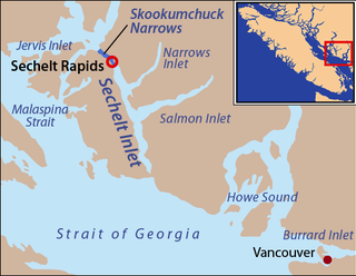
Narrows Inlet formerly Narrows Arm is a fjord branching east from Sechelt Inlet in British Columbia, Canada. Its companion, Salmon Inlet, another side-inlet of Sechelt Inlet, lies roughly 10 km (6.2 mi) south.