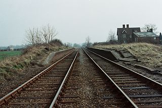
Verney Junction was an isolated railway station at a four-way railway junction in Buckinghamshire, open from 1868 to 1968; a junction existed through the site without a station from 1851.

CKHJ is a Canadian radio station in Fredericton, New Brunswick broadcasting at 1260 on the AM dial. The station broadcasts a country music format under the "KHJ" branding. The station is owned by Bell Media which also owns sister stations CFXY-FM and CIBX-FM.
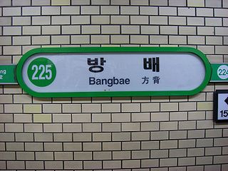
Bangbae Station is station number 225, on the Seoul Subway Line 2. The tomb of Grand Prince Hyoryeong (효령대군), the second son of King Taejong—the third monarch of the Joseon Dynasty—is located to the northeast.
The Bella Coola River is a major river on the Pacific slope of the Coast Mountains in southern British Columbia. The town of Bella Coola is at its mouth on North Bentinck Arm. Bella Coola Indian Reserve No. 1 the location of the main community today of the surviving population of the Nuxalk who gathered there after depredations by smallpox and colonialization.

The Rocky Mountain Floristic Region, also known as the Rocky Mountain Floristic Province, is a floristic region within the Holarctic Kingdom in western North America delineated by Armen Takhtajan and Robert F. Thorne. The region extends from Kodiak Island in Alaska to the San Francisco Bay Area and Sierra Nevada in California. The Vancouverian Province comprises the coastal part of the region for its entire length, including the Pacific Coast Ranges, and the Rocky Mountain Province includes the Rocky Mountains and associated ranges. There are no endemic plant families in the region but many endemic genera and species.
Gilford Island is an island in British Columbia, Canada, located between Tribune Channel and Knight Inlet. The island has an area of 382 square kilometres (147 sq mi). Turnour Island is to the south across Tribune Channel, the entrance to Thompson Sound to the east.

The Sutton Range is a mountain range on Vancouver Island, British Columbia, Canada, located in the area between the headwaters of the Nimpkish River and those of the White River. It has an area of 448 km2 and is a subrange of the Vancouver Island Ranges which in turn form part of the Insular Mountains.
The Franklin Range is a small mountain range on Vancouver Island, British Columbia, Canada, located just southwest of Robson Bight and Johnstone Strait. It has an area of 200 km2 and is a subrange of the Vancouver Island Ranges which in turn form part of the Insular Mountains. The range was named in 1861 by Captain Richards for noted Arctic explorer Rear Admiral Sir John Franklin who died exploring the Arctic and his wife, Lady Franklin. The Cracroft Islands across Johnstone Strait were named for Sophia Cracroft, Sir John's niece who accompanied Lady Franklin on her journey around the world that brought them to British Columbia during the Fraser Gold Rush of 1858.

Sir Harry Verney, 2nd Baronet PC, DL, JP was an English soldier and Liberal politician who sat in the House of Commons variously between 1832 and 1885.
The Wrede Range is a small subrange of the Swannell Ranges of the Omineca Mountains, located between Ingenika River and Wrede Creek in northern British Columbia, Canada.
Grappler Sound is a sound on the Coast of British Columbia, Canada. It is located on the west side of Watson Island, in the area of the Broughton Archipelago and which is located at the entrance to Mackenzie Sound. It was named for HMS Grappler.
Wedge Pass, also known as Billygoat Pass, 1430 m (4692 ft), is a mountain pass in the northern Garibaldi Ranges, the southwesternmost subdivisions of the Pacific Ranges of the Coast Mountains in British Columbia, Canada. Located immediately on the southern flank of Wedge Mountain and to the immediate north of the Spearhead Range, site of the Blackcomb half of the Whistler Blackcomb Ski Area, it connects the head of Wedge Creek (W), a tributary of the Green River with those of Billgoat Creek (E), a tributary of the Lillooet River. The pass is within Garibaldi Provincial Park and has no road access.
The Tottenham Range is a small mountain range in southwestern British Columbia, Canada, located between Seymour Inlet and at the head of Belize Inlet. It has an area of 46 km2 and is a subrange of the Pacific Ranges which in turn form part of the Coast Mountains.
The Pembroke Range is a small mountain range in southwestern British Columbia, Canada, located between Loughborough Inlet and Phillips Arm. It has an area of 75 km2 and is a subrange of the Pacific Ranges which in turn form part of the Coast Mountains.
Mount Gilbert, 3124 m prominence: 484 m, is a mountain in the Pacific Ranges of the Coast Mountains of British Columbia, Canada. It is located south of the confluence of the Bishop and Southgate Rivers and to the west of the Compton Névé, a large icefield, and to the south of the Homathko Icefield, another large icefield.

The Terminal Range is the northernmost mountain range of the Canadian Rockies, so-named for its position at the northern terminus of the Rockies. Lying west of Muncho Lake and the Trout River, its northern perimeter is the Liard River. The Sentinel Range lies to its east.

HMS Grappler was an Albacore-class gunboat of the Royal Navy. She served on what is now the British Columbia Coast from 1859 until sold into commercial service in 1868. She sank with significant loss of life as result of a fire in 1883.
Petlushkwohap Mountain, elev. 2939 m, is a mountain in the Cantilever Range, located west of the town of Lytton, British Columbia, Canada, in that province's Fraser Canyon region. The Cantilever Range is a small subrange of the Lillooet Ranges, the southeasternmost subrange of the Pacific Ranges of the Coast Mountains. Petlushkwohap is the second-highest summit in the Lillooet Ranges, after nearby Skihist Mountain and is one of the mountains within the Stein Valley Nlaka'pamux Heritage Park.
Nusatsum Mountain, is a mountain in the Pacific Ranges of the Coast Mountains of British Columbia, Canada, located near the Nusatsum River and south of and between the communities of Firvale and Hagensborg. The mountain is the equivalent of Mount Ararat in the traditions of the Nuxalk, as the place where survivors found refuge from the Great Flood.
The Kakweiken River, also spelled Kakweken River, is a river in the Central Coast region of British Columbia, Canada, flowing southwest out of the Pacific Ranges of the Coast Mountains into the head of Thompson Sound, which lies to the east of Gilford Island and to the north of lower Knight Inlet. Located at the mouth of the river is Kakweken Indian Reserve No. 4, which is under the administration of the Kwikwasut'inuxw Haxwa'mis First Nation.


