Tantalus Range

Last updated
Tantalus Range
Tantalusrange.JPG
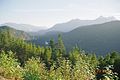
Tantalus Range from the Sea to Sky Highway
Highest point
PeakMount Tantalus
Elevation 2,603 m (8,540 ft) [1]
Coordinates 49°49′05″N123°19′46″W / 49.81806°N 123.32944°W / 49.81806; -123.32944 Coordinates: 49°49′05″N123°19′46″W / 49.81806°N 123.32944°W / 49.81806; -123.32944 [1]
Naming
Native nameTsewílx’  (Squamish)
Geography
Vancouver Island-relief+TantalusRange.png
Location map of the Tantalus Range
CountryCanada
ProvinceBritish Columbia
Parent range Pacific Ranges
Borders on Garibaldi Ranges, Clendinning Range and North Shore Mountains

The Tantalus Range is a subrange of the Pacific Ranges of the Coast Mountains in southern British Columbia, Canada. The range is easily viewed from the "Sea to Sky Highway" that travels from Vancouver to Squamish and Whistler. To Squamish people, the local indigenous people of the area, the name of the Tantalus Range is Tsewílx’ (/tʃə.wilχ/).

Contents

The range's southern end is on the western edge of Squamish and it runs only about 35 km northwest on the west bank of the Squamish River and is less than 16 km wide at its widest. It is about 460000 ha (4600 km² or 1775 mi²) in area. Mount Tantalus, 2,603 metres (8,540 ft), is the highest in the range.

The origin of the name, as well as the names of many of its peaks, are from Greek mythology. Tantalus was doomed in Hades to be half-submerged in cold water with fruit dangling close but not close enough to eat, which is where the word tantalize has its root. Allegedly the name was conferred by a local mountain climber who was "tantalized" by the sight of the range's impressive spires and icefalls from across the turbulent waters of the Squamish River. [ citation needed ] Alternately, another version of the legend has Tantalus and his family frozen before a banquet, unable to move - very descriptive of the ice-draped and somehow regal character of the peaks and icefields of the range. [ citation needed ].

The Tantalus Range is a favourite with climbers, and also with photographers and filmmakers. The best views of it can be had just north of Squamish from the Brohm Ridge and Cheakamus Canyon stretches of BC Highway 99 (the Sea-to-Sky Highway).

Neighbouring ranges:

(unnamed ranges not listed at present)

See also

Related Research Articles

Whistler is a resort municipality in the southern Pacific Ranges of the Coast Mountains in the unceded territories of Squamish, British Columbia. Approximately 125 km (78 mi) north of Vancouver and 36 km (22 mi) south of Pemberton, it is incorporated as the Resort Municipality of Whistler (RMOW). It has a permanent population of approximately 13,982 (2021), as well as a larger but rotating population of seasonal workers.

<span class="mw-page-title-main">San Gabriel Mountains</span> Mountain range of the Transverse Ranges in California, United States

The San Gabriel Mountains are a mountain range located in northern Los Angeles County and western San Bernardino County, California, United States. The mountain range is part of the Transverse Ranges and lies between the Los Angeles Basin and the Mojave Desert, with Interstate 5 to the west and Interstate 15 to the east. The range lies in, and is surrounded by, the Angeles and San Bernardino National Forests, with the San Andreas Fault as its northern border.

<span class="mw-page-title-main">Mount Garibaldi</span> Stratovolcano in British Columbia, Canada

Mount Garibaldi is a dormant stratovolcano in the Garibaldi Ranges of the Pacific Ranges in southwestern British Columbia, Canada. It has a maximum elevation of 2,678 metres and rises above the surrounding landscape on the east side of the Cheakamus River in New Westminster Land District. Mount Garibaldi contains three summits, two of which are individually named. Atwell Peak is a sharp, conical summit slightly higher than the more rounded summit of Dalton Dome. Both summits were volcanically active at different times throughout Mount Garibaldi's eruptive history. The northern and eastern flanks of Mount Garibaldi are obscured by the Garibaldi Névé, a large snowfield containing several radiating glaciers. Flowing from the steep western face of Mount Garibaldi is the Cheekye River, a tributary of the Cheakamus River. Opal Cone on the southeastern flank is a small volcanic cone from which a lengthy lava flow descends. The western face is a landslide feature that formed in a series of collapses between 12,800 and 11,500 years ago. These collapses resulted in the formation of a large debris flow deposit that fans out into the Squamish Valley.

Highway 99, also known as the Fraser Delta Thruway south of Vancouver, and the Sea to Sky Highway, Squamish Highway, or Whistler Highway north of Vancouver, is the major north–south artery running through the Greater Vancouver area of British Columbia from the U.S. border, up Howe Sound through the Sea to Sky Country to Lillooet, and connecting to Highway 97 just north of Cache Creek. The highway's number was derived from the former U.S. Route 99, with which the highway originally connected to at the border. The highway currently connects with Interstate 5 at the United States border.

<span class="mw-page-title-main">Stanley Peak (Ball Range)</span> Mountain in Kootenay NP, British Columbia, Canada

Stanley Peak is a 3,155-metre (10,351 ft) mountain located in the Ball Range, at the northeastern section of Kootenay National Park, in the Canadian Rocky Mountains. The mountain was named in 1901 by its first climber, the English explorer Edward Whymper, after Frederick Stanley, 16th Earl of Derby, the sixth Governor-General of Canada. There are sources that date the naming in 1912 after Stanley H. Mitchell, Secretary-Treasurer of Alpine Club of Canada.

<span class="mw-page-title-main">Squamish, British Columbia</span> District municipality in British Columbia, Canada

Squamish is a community and a district municipality in the Canadian province of British Columbia, located at the north end of Howe Sound on the Sea to Sky Highway. The population of the Squamish census agglomeration, which includes First Nation reserves of the Squamish Nation although they are not governed by the municipality, is 19,893.

<span class="mw-page-title-main">Never Summer Mountains</span> Mountain range in Colorado, US

The Never Summer Mountains are a mountain range in the Rocky Mountains in north central Colorado in the United States consisting of seventeen named peaks. The range is located along the northwest border of Rocky Mountain National Park, forming the continental divide between the headwaters of the Colorado River in Rocky Mountain National Park to the local-east and the upper basin of the North Platte River to the local-west; the continental divide makes a loop in these mountains. The range is small and tall, covering only 25 sq mi (65 km2) with a north-south length of 10 mi (16 km) while rising to over 12,000 ft (3,700 m) at over ten distinct peaks. The range straddles the Jackson-Grand county line for most of its length, and stretches into Jackson and Larimer county at its northern end. A panoramic view of the range is available from sections of Trail Ridge Road in Rocky Mountain National Park. One of the northernmost peaks, Nokhu Crags, is prominently visible from the west side of Cameron Pass.

<span class="mw-page-title-main">Stawamus Chief</span>

The Stawamus Chief, officially Stawamus Chief Mountain, is a granitic dome located adjacent to the town of Squamish, British Columbia, Canada. It towers over 700 m (2,297 ft) above the waters of nearby Howe Sound. It is one of the largest granite monoliths in the world.

<span class="mw-page-title-main">Howe Sound</span> Body of water

Howe Sound is a roughly triangular sound, that joins a network of fjords situated immediately northwest of Vancouver, British Columbia.

<span class="mw-page-title-main">Cheakamus River</span> River in British Columbia, Canada

The Cheakamus River is a tributary of the Squamish River, beginning on the west slopes of Outlier Peak in Garibaldi Provincial Park upstream from Cheakamus Lake on the southeastern outskirts of the resort area of Whistler. The river flows into Cheakamus Lake before exiting it and flowing northwest until it turns south and enters Daisy Lake. Between the outlet of Daisy Lake and its mouth, much of its length is spent going through Cheakamus Canyon, where the river flows through swift rapids and even one good sized waterfall. The river flows south from the lake and through the canyon before joining the Squamish River at Cheekye, a few miles north of the town of Squamish. The river's name is an anglicization of the name of Chiyakmesh, a village of the Squamish people and a reserve of the Squamish Nation.

<span class="mw-page-title-main">Breccia Peak (Wyoming)</span> Mountain in Wyoming, United States

Breccia Peak is a mountain in the southern Absaroka Range of the Rocky Mountains. It is located in Teton County in the U.S. state of Wyoming, close to the southwest border of the Teton Wilderness within the Bridger-Teton National Forest.

<span class="mw-page-title-main">Alpha Mountain</span>

Alpha Mountain is a 2,302-metre (7,552-foot) summit located in the Tantalus Range, in Tantalus Provincial Park, in southwestern British Columbia, Canada. It is situated 14 km (9 mi) northwest of Squamish, and 4.6 km (3 mi) southeast of Mount Tantalus, which is the highest peak in the Tantalus Range. Its nearest higher peak is Serratus Mountain, 1.9 km (1 mi) to the west. The Serratus Glacier lies to the west of Alpha, unnamed glaciers lie on the northern and eastern slopes, and Lake Lovely Water lies below the south slope. Precipitation runoff from the peak drains into tributaries of the Squamish River.

<span class="mw-page-title-main">Mount Niobe</span>

Mount Niobe is a 2,021-metre (6,631-foot) summit located in the Tantalus Range, in Tantalus Provincial Park, in southwestern British Columbia, Canada. It is situated 10 km (6 mi) northwest of Squamish, and 7.2 km (4 mi) southeast of Mount Tantalus, which is the highest peak in the Tantalus Range. Its nearest higher peak is Lydia Mountain, 2.03 km (1 mi) to the west-northwest, and Omega Mountain lies 1.1 km (1 mi) to the east. Lake Lovely Water lies below the northern slope of the peak and precipitation runoff from the peak drains into tributaries of the Squamish River. The first ascent of the mountain was made in 1910 by E. Kingsford-Smith and G. Warren via the south side. The mountain's name was officially adopted on June 6, 1957, by the Geographical Names Board of Canada. The mountain was named for Niobe, daughter of Tantalus in Greek mythology, with several peaks in the Tantalus Range being named for family members of Tantalus.

<span class="mw-page-title-main">Ossa Mountain</span>

Ossa Mountain is a 2,261-metre (7,418-foot) summit located in the Tantalus Range, in Tantalus Provincial Park, in southwestern British Columbia, Canada. It is situated 21 km (13 mi) northwest of Squamish, and 3.54 km (2 mi) north-northwest of Mount Tantalus, which is the highest peak in the Tantalus Range. Its nearest higher peak is Pelion Mountain, 0.77 km (0 mi) to the east. Unnamed glaciers lie on the northern and eastern slopes. Precipitation runoff from the peak drains into tributaries of the Squamish River and Clowhom River. The first ascent of the mountain was made on July 25, 1960, by Dick Chambers, Jack Bryan, and Howie Rode via the east ridge. The mountain names in the Tantalus Range have a Greek mythology theme, and Ossa Mountain was named for legendary Mount Ossa in Thessaly, upon which the Aloadaes are said to have attempted to pile Mount Pelion on top of Mount Ossa in their attempt to scale Olympus, home of the Greek gods. The mountain's name was officially adopted on June 6, 1957, by the Geographical Names Board of Canada.

<span class="mw-page-title-main">Omega Mountain</span>

Omega Mountain is a 1,918-metre (6,293-foot) summit located in the Tantalus Range, in Tantalus Provincial Park, in southwestern British Columbia, Canada. It is situated 10 km (6 mi) northwest of Squamish, and 8.2 km (5 mi) southeast of Mount Tantalus, which is the highest peak in the Tantalus Range. Its nearest higher peak is Mount Pelops, 1.7 km (1 mi) to the west. Lake Lovely Water lies below the northwestern slope of the peak with Alpha Mountain on the opposite side of the lake. Precipitation runoff from the peak drains into tributaries of the Squamish River. The first ascent of the mountain was made in 1916 by Tom Fyles and his brother, John Fyles. The mountain's name comes from Omega, in keeping with nearby peaks being named for Greek alphabet letters, namely Alpha and Iota mountains. Its name was officially adopted on June 6, 1957, by the Geographical Names Board of Canada.

<span class="mw-page-title-main">Mount Dione</span>

Mount Dione is a 2,589-metre (8,494-foot) summit located in the Tantalus Range, in Tantalus Provincial Park, in southwestern British Columbia, Canada. It is situated 17 km (11 mi) northwest of Squamish, and 0.24 km (0 mi) north of Mount Tantalus, which is its nearest higher peak and the highest peak in the Tantalus Range. The Dione Glacier lies on the southern slope, and the Rumbling Glacier lies to the northeast. Precipitation runoff from the peak drains east into tributaries of the Squamish River, or west into tributaries of the Clowhom River. The first ascent of the mountain was made in 1916 by Tom Fyles and his brother, John Fyles, via the southeast ridge. The mountain names in the Tantalus Range have a Greek mythology theme, and Mount Dione was named for Dione, the wife of Tantalus. The mountain's name was submitted by Neal Carter of the British Columbia Mountaineering Club, and was officially adopted on June 6, 1957, by the Geographical Names Board of Canada.

<span class="mw-page-title-main">Mount Pelops</span>

Mount Pelops is a 2,015-metre (6,611-foot) mountain summit located in the Tantalus Range, in Tantalus Provincial Park, in southwestern British Columbia, Canada. It is situated 10 km (6 mi) northwest of Squamish, and 7.5 km (5 mi) southeast of Mount Tantalus, which is the highest peak in the Tantalus Range. Its nearest higher peak is Mount Niobe, 0.2 km (0 mi) to the northwest, and Omega Mountain lies 1.7 km (1 mi) to the east. Precipitation runoff from the peak drains into tributaries of the Squamish River. The first ascent of the mountain was made in 1916 by Tom Fyles and his brother, John Fyles. The mountain was named for Pelops, brother of Niobe and son of Tantalus according to Greek mythology, with several peaks in the Tantalus Range being named for family members of Tantalus. The mountain's name was officially adopted on June 6, 1957, by the Geographical Names Board of Canada.

<span class="mw-page-title-main">Mount Thyestes</span>

Mount Thyestes is a 1,697-metre (5,568-foot) mountain summit located in the Tantalus Range, in Tantalus Provincial Park, in southwestern British Columbia, Canada. It is situated 4 km (2 mi) immediately west of Brackendale, 7 km (4 mi) northwest of Squamish, and 10.7 km (7 mi) southeast of Mount Tantalus, which is the highest peak in the Tantalus Range. Its nearest higher peak is Omega Mountain, 2.4 km (1 mi) to the northwest, and Mount Pelops lies 3.6 km (2 mi) to the west-northwest. Precipitation runoff from the peak drains into tributaries of the Squamish River. The first ascent of the mountain was made in 1942 by R. McLellan, H. Parliament, and F. Roots. The mountain was named for Thyestes, son of Pelops and grandson of Tantalus according to Greek mythology. The mountain's name was officially adopted on June 6, 1957, by the Geographical Names Board of Canada.

<span class="mw-page-title-main">Pelion Mountain</span>

Pelion Mountain is a 2,312-metre (7,585-foot) summit located in the Tantalus Range, in Tantalus Provincial Park, in southwestern British Columbia, Canada. It is situated 21 km (13 mi) northwest of Squamish, 0.8 km (0 mi) east of Ossa Mountain, and 5.5 km (3 mi) north-northwest of Mount Tantalus, which is its nearest higher peak and the highest peak in the Tantalus Range. Unnamed glaciers surround the peak and precipitation runoff from the peak drains into tributaries of the Squamish River and Clowhom River. The first ascent of the mountain was made in 1944 by V. Brink and B. McLellan. The mountain names in the Tantalus Range have a Greek mythology theme, and Pelion Mountain was named for the legendary Pelion mountain in Thessaly, upon which the Aloadaes are said to have attempted to pile Mount Pelion on top of Mount Ossa in their attempt to scale Olympus, home of the Greek gods. The mountain's name was officially adopted on June 6, 1957, by the Geographical Names Board of Canada.

<span class="mw-page-title-main">Lydia Mountain</span>

Lydia Mountain is a 2,100-metre (6,890-foot) summit located in the Tantalus Range, in Tantalus Provincial Park, in southwestern British Columbia, Canada. It is situated 14.5 km (9 mi) northwest of Squamish, and 5.46 km (3 mi) south-southeast of Mount Tantalus, which is the highest peak in the Tantalus Range. The nearest higher neighbor is The Red Tusk, 0.5 km (0 mi) to the west, and Mount Niobe lies 2.17 km (1 mi) to the east-southeast. Lake Lovely Water lies below the eastern slope of the peak and precipitation runoff from the peak drains east to the Squamish River, and west to the Clowhom River via Red Tusk Creek. Topographic relief is significant as Lydia Mountain rises 1,400 meters (4,600 feet) above Red Tusk Creek in approximately three kilometers (two miles). The mountain's name was officially adopted on June 6, 1957, by the Geographical Names Board of Canada. The mountain was named for mythic Lydia, of which Tantalus was a primordial ruler in Greek mythology. Several peaks in the Tantalus Range are named in association with Tantalus.

References

  1. 1 2 "Mount Tantalus". Bivouac.com. Retrieved 2021-07-19.