The Stʼatʼimc, also known as the Lillooet, St̓át̓imc, Stl'atl'imx, etc., are an Interior Salish people located in the southern Coast Mountains and Fraser Canyon region of the Interior of the Canadian province of British Columbia.

The Fraser Canyon is a major landform of the Fraser River where it descends rapidly through narrow rock gorges in the Coast Mountains en route from the Interior Plateau of British Columbia to the Fraser Valley. Colloquially, the term "Fraser Canyon" is often used to include the Thompson Canyon from Lytton to Ashcroft, since they form the same highway route which most people are familiar with, although it is actually reckoned to begin above Williams Lake, British Columbia at Soda Creek Canyon near the town of the same name.

The Clear Range is a small mountain range located in the angle of the Fraser and Thompson Rivers in south-central British Columbia. It has a small subdivision just northeast of that confluence named the Scarped Range. The Clear Range totals 16,270 km² (6,280 mi²) and is 75 km (47 mi) north to south and 35 km (22 mi) east to west. The Clear Range and its northward neighbour the Marble Range are both subranges of the Pavilion Range.

Seton Lake is a freshwater fjord draining east via the Seton River into the Fraser River at the town of Lillooet, about 22 km (14 mi) long, 26.2 km2 (10.1 sq mi) in area and lies at an elevation of 243 m (797 ft). Its depth is 460 m (1,500 ft).

The Pacific Ranges are the southernmost subdivision of the Coast Mountains portion of the Pacific Cordillera. Located entirely within British Columbia, Canada, they run northwest from the lower stretches of the Fraser River to Bella Coola and Burke Channel, north of which are the Kitimat Ranges. The Coast Mountains lie between the Interior Plateau and the Coast of British Columbia.

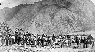
The Douglas Road, a.k.a. the Lillooet Trail, Harrison Trail or Lakes Route, was a goldrush-era transportation route from the British Columbia Coast to the Interior. Over 30,000 men are reckoned to have travelled the route in, although by the end of the 1860s it was virtually abandoned due to the construction of the Cariboo Wagon Road, which bypassed the region.
The Douglas Ranges are a subrange of the Pacific Ranges of the Coast Mountains of the Canadian province of British Columbia, about 70 km (43 mi) east of downtown Vancouver, north of the Fraser River and between the valleys of Stave and Harrison Lakes. They are approximately 4,900 km2 (1,900 sq mi) in area. Their highest peak is Mount Robertson 2,252 m (7,388 ft), at the northwest limit of the range.

The Camelsfoot Range is a sub-range of the Chilcotin Ranges subdivision of the Pacific Ranges of the Coast Mountains in British Columbia. The Fraser River forms its eastern boundary. The range is approximately 90 km at its maximum length and less than 30 km wide at its widest.
The Cayoosh Range is the northernmost section of the Lillooet Ranges, which are a subrange of the Pacific Ranges of the Coast Mountains in British Columbia, Canada. The range covers an area of c. 3770 km² and is approximately 65 km (40 mi) SW to NE and about 20 km (12 mi) SE to NW.

The Cantilever Range is a mountain range in southwestern British Columbia, Canada, a subrange of the Lillooet Ranges, which is itself a subgrouping of the Pacific Ranges of the Coast Mountains. About 1100 km2 in area and about 50 km east to west and 35 km north to south, the Cantilever Range is located southwest of Lytton between the valleys of the Stein River (N) and Kwoiek Creek (S).
N'Quatqua, variously spelled Nequatque, N'quat'qua, is the proper historic name in the St'at'imcets language for the First Nations village of the Stl'atl'imx people of the community of D'Arcy, which is at the upper end of Anderson Lake about 35 miles southeast of Lillooet and about the same distance from Pemberton. The usage is synonymous with Nequatque Indian Reserve No. 1, which is 177 ha. in size and located adjacent to the mouth of the Gates River.

The Birkenhead River, formerly known as the Portage River, the Pole River and the Mosquito River, is a major tributary of the Lillooet River, which via Harrison Lake and the Harrison River is one of the major tributaries of the lower Fraser River. It is just over 50 km long from its upper reaches in the unnamed ranges south of Bralorne, British Columbia ; their western area towards the named Bendor Range east of Bralorne is sometimes called the Cadwallader Ranges.
Skihist Mountain, also sometimes referred to as Skihist Peak, is the highest mountain in the Cantilever Range and in southwestern British Columbia, Canada. It is located on the southern boundary of Stein Valley Nlaka'pamux Heritage Park, about 20 km (12 mi) west of Lytton. It is the highest summit in the Lillooet Ranges, which lie between the Lillooet and Fraser Rivers, south of the Gates Valley and Seton and Anderson Lakes.
The Lillooet Country, also referred to as the Lillooet District, is a region spanning from the central Fraser Canyon town of Lillooet west to the valley of the Lillooet River, and including the valleys in between, in the Southern Interior of British Columbia. Like other historical BC regions, it is sometimes referred to simply as The Lillooet or even Lillooet,.
Cayoosh Pass is a mountain pass in the Lillooet Ranges of the Pacific Ranges of the southern Coast Mountains in British Columbia, Canada. It lies just west of Duffey Lake on BC Highway 99 between the towns of Lillooet and Pemberton, formed by the headwaters of Cayoosh Creek to the east, flowing to the Fraser River at Lillooet, and Joffre Creek to the west, flowing steeply downhill to Lillooet Lake just southeast of the Mount Currie Indian Reserve.
Pemberton Pass, 505 m (1,657 ft), also formerly known as Mosquito Pass, is the lowest point on the divide between the Lillooet and Fraser River drainages, located at Birken, British Columbia, Canada, in the principal valley connecting and between Pemberton and Lillooet. The pass is a steep-sided but flat-bottomed valley adjacent to Mount Birkenhead and forming a divide between Poole Creek, a tributary of the Birkenhead River, which joins the Lillooet at Lillooet Lake, and the Gates River which flows northeast from Gates Lake, at the summit of the pass, which flows to the Fraser via Anderson and Seton Lakes and the Seton River.

Cayoosh Creek is a northeast-flowing tributary of the Seton River in the Canadian province of British Columbia. The name Cayoosh Creek remains on the bridge-sign crossing the stream on BC Highway 99 and continues in use locally to refer to the final reaches of the Seton River, formerly Seton Creek, which prior to the renaming ending at the confluence with Cayoosh Creek. The creek is the namesake of Cayoosh Creek Indian Reserve No. 1, one of the main Indian reserves of the Cayoose Creek Indian Band, which lies adjacent to what was renamed the Seton River without local consultation.
Mission Ridge, also known as Mission Mountain, is a ridge in the Bridge River-Lillooet Country of the South-Central Interior of British Columbia, Canada, extending westward from the town of Lillooet along the north side of Seton Lake to Mission Pass, which is immediately above and to the north of the lakeside community of Shalalth. The road over the pass is also known as Mission Mountain, which is short for "Mission Mountain Road". Mission Creek lies on the north side of the pass, and is a tributary of the Bridge River, the lower reaches of which lie on the north side of the ridge, and which was the only road access into the upper Bridge River Country before the construction of a road through the Bridge River Canyon in the mid-1950s opened that region up to road access from the lower Bridge River valley and the town of Lillooet via the community of Moha. Most, or virtually all, of the ridge, is Indian Reserves, notably Slosh 1, under the administration of the Seton Lake Indian Band, and Bridge River 1, which is under the administration of the Bridge River Indian Band. Parts of the ridge's eastern end are in reserves controlled by the Lillooet Indian Band, including its final spires above Lillooet, which were dubbed St. Mary's Mount by the Reverend Lundin Brown in the 1860s, though that name never stuck and is ungazetted.
Petlushkwohap Mountain is a mountain in the Cantilever Range, located west of the town of Lytton, British Columbia, Canada, in that province's Fraser Canyon region. The Cantilever Range is a small subrange of the Lillooet Ranges, the southeasternmost subrange of the Pacific Ranges of the Coast Mountains. Petlushkwohap is the second-highest summit in the Lillooet Ranges, after nearby Skihist Mountain and is one of the mountains within the Stein Valley Nlaka'pamux Heritage Park.
The Lillooet Land District is one of the 59 cadastral subdivisions of British Columbia, which were created by the Lands Act of the Colony of British Columbia in 1859, defined as "a territorial division with legally defined boundaries for administrative purposes". The land district's boundaries came to be used as the boundary of the initial Lillooet riding for the provincial Legislature from 1871, when the colony became a province. In addition to use in descriptions of land titles and lot surveys, the Land District was also the basis of the Lillooet Mining District.

