Grouse Mountain

Last updated
Grouse Mountain
Grouse Mountain Gondola.JPG
Grouse Mountain Skyride
Location British Columbia, Canada
Nearest major city North Vancouver
Coordinates 49°22′46.40″N123°4′54.49″W / 49.3795556°N 123.0818028°W / 49.3795556; -123.0818028
Vertical365 m (1,198 ft)
Top elevation1,231 m (4,039 ft)
Base elevation274 m (899 ft)
Skiable area212 acres
Runs 33 (14 night skiing)
17% beginner
54% intermediate
21% advanced
8% expert
Lift system 4 chairlifts
1 magic carpet
Website www.grousemountain.com
An abandoned aircraft engine, remaining near the old chairlift route and the 1954 F-86 crash site Grouse-Mt-forest-big-iron-thing-3656.jpg
An abandoned aircraft engine, remaining near the old chairlift route and the 1954 F-86 crash site
Sun setting on the modern-day mountaintop chalet and lodge (left) as seen from the tram's passenger gate GrouseMountain.jpg
Sun setting on the modern-day mountaintop chalet and lodge (left) as seen from the tram's passenger gate

Grouse Mountain is one of the North Shore Mountains of the Pacific Ranges in the District Municipality of North Vancouver, British Columbia, Canada. With a maximum elevation of over 1,200m (4,100ft) at its peak, the mountain is the site of an alpine ski area, Grouse Mountain Resort, which overlooks Metro Vancouver and has four chairlifts servicing 33 runs. In the summer, Grouse Mountain Resort features lumberjack shows, the "Birds in Motion" birds of prey demonstration, a chairlift ride, disc golf, mountain biking, zip lining, tandem paragliding, helicopter tours, and guided ecowalks. Year-round operations include a 100-seat mountaintop theatre and a wildlife refuge. The mountain operates two aerial tramways, known officially as the Skyride. The Blue Skyride is used mainly for freight transportation, while public access to the mountain top is provided by the Swiss-built Garaventa Red Skyride, which has a maximum capacity of 101 passengers (98 + 1 operator in summer). Summer access is also provided by the 2.9 kilometre Grouse Grind hiking trail, which is open for hiking from May to October. Similar to the nearby Capilano Suspension bridge, Grouse Mountain can be accessed via a free, regular shuttle bus that runs from 'Canada Place' in downtown Vancouver.

Contents

History

Original ski area

Grouse Mountain gets its name from the sooty grouse commonly found throughout the mountain. It was named in October 1894 by the first hikers to reach its peak, after the sooty (blue) grouse, a game bird of the area. [1]

Grouse Mountain's first lodge was hand-built by Scandinavians in the 1920s. They hauled planks up what would become the Grouse Grind hiking trail for the venture. Another company wanted to build a funicular railway for a private resort on the mountain, though that venture never materialized. By the 1930s, a toll road was built to the top via the slope of what is now the mountain's primary ski run, the "Cut", to access the lodge.

The area at the bottom of the "Cut"—one of Vancouver's most well-known ski runs—is the original base of the mountain, where the area's first lodge and rope tow were built. Since several cottages were constructed in the trees surrounding the lodge and the base of the old Cut chairlift, the base came to be known as the "Village" by local skiers. These cabins are situated beneath and to the west of the former Cut chairlift, where some of them are still in use. The Old Grouse Mountain Highway, a gravel road that was constructed to provide access to the base, is still in place and is today solely used for ski area upkeep.

In 1949, the mountain's first double chairlift was constructed, allowing skiing down the cut from the top of the ridge. Grouse Mountain claims this lift to have been the world's first double chairlift, however, it was actually the second chairlift in Vancouver after the "Hollyburn" at Cypress Bowl and the third in Canada after Red Mountain Resort; the first chair in the world was at Sun Valley in 1936. [2] Two years later, in 1951, another a longer lift, running from a bus stop on Skyline Drive, at the bottom of the mountain, was opened, known as the Village Chair. This two seater chairlift included wooden towers (some of these towers and the lift line cable wheels are still visible on a hike following the Village Chair's lift line). Each of the chairs were, for a time, equipped with a metal roof to keep skiers dry on rainy or snowy days during the ride up to the base of the old Cut Chair lift.

Present-day lodge and ski area

After a fire destroyed the original lodge in the winter of 1962, the two original lifts were removed in the 1970s. The government of British Columbia, seeing the possibilities for tourism, provided funding and permits for a new lodge to be built on the ridge, as well as an aerial tramway travelling to the mountaintop from the valley below. The tramway, known as the Blue Tram, was built by Austrian steel company Voestalpine and was opened and inaugurated on December 15, 1966, by Premier W. A. C. Bennett.

Ten years later, the mountain was purchased from its original owners by the McLaughlin family in 1976. The new ownership provided additional funding for the construction of a second aerial tramway, built by Garaventa, known as the Red Tram or Super Skyride, that same year. The Super Skyride, using much larger tram cars holding just under 100 passengers, is now the main tram, arriving at a separate top terminal building a short walk from the lodge. The older Blue Tram is now mainly used to transport supplies directly to the lodge structure.

The Peak and Blueberry Chairs, which were both created in the 1960s and early 1970s, as well as the additional Inferno Chair, which was built in 1976, were featured in the new ski area. The McLaughlin family had only partial ownership of the mountain until they acquired complete ownership in 1989. They then expanded the current lodge to build Canada's first high-definition theater, known as the Theatre in the Sky, in 1990.

As the Inferno, Blueberry and Peak Chairs began to age in the 2000s, all three lifts were removed due to insurance issues, beginning with the Inferno in late 2003 and the Blueberry and Peak the following year. All three were effectively replaced by Grouse Mountain's second high-speed and detachable quad chair built by North American aerial lift manufacturer Leitner-Poma for the 2005 winter season. (The first was the Screaming Eagle on the Cut.) The chair was named the Olympic Express in commemoration of Vancouver's recent designation for the 2010 Winter Games. Although no official 2010 Olympic events were held on the mountain (snowboard and freestyle ski races took place at the Cypress Mountain Ski Area a few kilometres to the west), during the Games, NBC Today broadcast its coverage of the games live from Grouse Mountain.

In 2008, Grouse Mountain constructed two new quad chairs; one to replace the Courtesy rope tow at the bottom of the Paradise run and the other to replace the defunct peak chair, which closed after the Olympic Express was built in 2004. Both chairlifts were designed to run at a slower speed to accommodate beginners and children.

Climate

Grouse Mountain has an humid continental climate (Köppen climate type Dfb), falling exactly on the borderline with subarctic climate (Köppen Dfc).

The average annual precipitation is 2730mm. Autumn is the wettest season with 421.4 mm (16.59 in) of precipitation falling in November alone. Winters are cool and snowy, with an average of 868.7 centimetres (342.0 in) of snow falling annually.

Winters are not cold by Canadian standards, due to how the mountain is moderated by the Pacific Ocean. However, due to its elevation, winters are by no means as mild as the Lower Mainland. In December (the coldest month statistically), Grouse Mountain has an average high and low of 1.3 °C (34.3 °F) and −3.2 °C (26.2 °F) respectively. This freeze/thaw cycle can allow for large amounts of rain to fall on some occasions every winter. Nonetheless, heavy snow is more frequent in the winter, which allows for a deep snow-pack, lasting on average from mid-November until early May.

Summer is warm and relatively dry. August is the warmest month, with an average high and low of 17.7 °C (63.9 °F) and 10.3 °C (50.5 °F) respectively.

Climate data for North Vancouver (Grouse Mountain Resort) (1981–2010) (Elevation: 1,103m)
MonthJanFebMarAprMayJunJulAugSepOctNovDecYear
Record high °C (°F)14.0
(57.2)
16.0
(60.8)
17.0
(62.6)
25.5
(77.9)
32.1
(89.8)
38.6
(101.5)
40.3
(104.5)
40.0
(104.0)
36.2
(97.2)
26.0
(78.8)
17.5
(63.5)
17.0
(62.6)
40.3
(104.5)
Mean daily maximum °C (°F)1.9
(35.4)
2.5
(36.5)
3.6
(38.5)
6.7
(44.1)
10.2
(50.4)
13.6
(56.5)
16.9
(62.4)
17.7
(63.9)
14.9
(58.8)
8.5
(47.3)
3.3
(37.9)
1.3
(34.3)
8.4
(47.1)
Daily mean °C (°F)−0.4
(31.3)
−0.1
(31.8)
1.0
(33.8)
3.6
(38.5)
6.9
(44.4)
10.0
(50.0)
13.2
(55.8)
14.1
(57.4)
11.4
(52.5)
5.9
(42.6)
1.0
(33.8)
−1.0
(30.2)
5.5
(41.9)
Mean daily minimum °C (°F)−2.6
(27.3)
−2.6
(27.3)
−1.6
(29.1)
0.5
(32.9)
3.5
(38.3)
6.3
(43.3)
9.4
(48.9)
10.3
(50.5)
7.9
(46.2)
3.1
(37.6)
−1.2
(29.8)
−3.2
(26.2)
2.5
(36.5)
Record low °C (°F)−23.4
(−10.1)
−24.8
(−12.6)
−16.9
(1.6)
−12.8
(9.0)
−7.5
(18.5)
−1.7
(28.9)
−1.1
(30.0)
1.1
(34.0)
−2.2
(28.0)
−12.6
(9.3)
−18
(0)
−24.6
(−12.3)
−24.8
(−12.6)
Average precipitation mm (inches)357.0
(14.06)
228.2
(8.98)
232.5
(9.15)
192.4
(7.57)
168.2
(6.62)
173.5
(6.83)
91.7
(3.61)
114.8
(4.52)
155.8
(6.13)
305.3
(12.02)
421.4
(16.59)
289.5
(11.40)
2,730.3
(107.49)
Average rainfall mm (inches)185.9
(7.32)
103.4
(4.07)
93.1
(3.67)
90.0
(3.54)
155.5
(6.12)
173.2
(6.82)
91.7
(3.61)
114.8
(4.52)
155.4
(6.12)
292.1
(11.50)
301.0
(11.85)
105.5
(4.15)
1,861.5
(73.29)
Average snowfall cm (inches)171.1
(67.4)
124.8
(49.1)
139.4
(54.9)
102.4
(40.3)
12.6
(5.0)
0.3
(0.1)
0.0
(0.0)
0.0
(0.0)
0.4
(0.2)
13.2
(5.2)
120.5
(47.4)
184.0
(72.4)
868.7
(342.0)
Average precipitation days (≥ 0.2 mm)18.714.916.216.414.413.59.28.410.615.820.217.1175.1
Average rainy days (≥ 0.2 mm)7.76.16.18.513.513.59.28.410.614.811.54.7114.4
Average snowy days (≥ 0.2 cm)13.511.312.39.52.30.130.00.00.082.411.814.577.7
Source: Environment Canada [3]

The Eye of the Wind

The 1.5 MW wind turbine Grouse Mountain windturbine.JPG
The 1.5 MW wind turbine

Grouse Mountain has built an observation deck (accessible by elevator) [4] on a 1.5 megawatt wind turbine of Leitwind LTW77-1500 type with 65 metres hub height and 76.8 metres rotor diameter at the peak of the resort. The facility, which is anticipated to eventually supply 25% of the resort's electricity, is the first wind turbine built in North America in an extreme high altitude location. [5] The design was recognized in the 2011 Consulting Engineers of British Columbia "Awards for Engineering Excellence". [6]

Construction of the turbine began in September 2008 as a participation between Grouse Mountain and Italy's Leitwind Technology. [5] It was inaugurated on February 5, 2010, by BC Premier Gordon Campbell prior to the Vancouver 2010 Winter Games. Tours of the facility officially began on February 26, 2010, and the turbine was connected to BC Hydro's transmission system on September 22, 2010.

The turbine weighs more than 250 tonnes and rises 65 metres from its base to the top of the tower. [4] Three 37.4 metre, fiberglass reinforced polyester blades sweep an area of 4,657 square metres. [4]

The project has had its difficulties: a dispute with BC Hydro over safety equipment was not resolved until late 2010, so the project generated no useful power until then. [7] The turbine is conspicuously visible from much of the city of Vancouver, and some are ambivalent about its effect on the skyline. [8] There were also concerns about the rapidly moving turbine blades hitting wildlife, [9] but as of 2015, no bird or bat deaths had been observed. The turbine foundation created a home for the American pika. [10]

Questions were also raised about claims made by Grouse Mountain Resorts about the power generation capability of the mill, estimated by GMR at 25% of the resort's needs, or enough energy to power 400 homes. [11]

Ski and snowboard

Grouse mountain's snow terrain, as seen from Burnaby, featuring the Cut (left) and expert peak runs (right) Grouse mountain (ski runs close up).JPG
Grouse mountain's snow terrain, as seen from Burnaby, featuring the Cut (left) and expert peak runs (right)
A panoramic view of Grouse Mountain in winter Grouse mountain winter panorama.jpg
A panoramic view of Grouse Mountain in winter

The ski and snowboard area, located on the southern slope of the mountain, operates in the winter months between December and May, approximately. Accessed by taking the tram from the base to the mountaintop chalet and lodge, it features four chairlifts (two high-speed quads, the Screaming Eagle and Olympic Express; and two quads, the Greenway and Peak Chairs) facilitating 33 runs, half of which are lit for night skiing and snowboarding. [12] [13]

The most prominent run on the mountain is the Cut, one of two beginner runs, which is easily visible from the Vancouver area. It runs alongside the Screaming Eagle chairlift. [12] East of the Cut are several intermediate runs, which take skiers and snowboarders down to the Olympic Express, which accesses the mountain's easternmost expert runs, most of which originate from the mountain's 1,231-metre (4,039 ft) peak. [12] Altogether, Grouse Mountain features four green (beginner), sixteen blue (intermediate), seven black diamond (advanced) and three double black diamond (expert) runs. [13] There are also three freestyle terrain parks—the novice to intermediate Rookie Terrain and Paradise Parks, as well as the intermediate to expert Side Cut Terrain Park. Depending on snow conditions, there is also another terrain park for experts called the Cut Jump Line, which is located on the left (east) side of the Cut. [14] In 2022, a dedicated handle tow was built to service the Side Cut Terrain Park. [15]

Grouse Mountain is also home to the Tyee Ski Club, [16] an organization for training children and youth to become competitive alpine ski racers in slalom, giant slalom and super-giant slalom skiing.

In addition to the 305 centimetres of annual natural snowfall, the mountain uses 37 snow guns, covering 75% of the ski and snowboard terrain, for artificial snowmaking. [13] With the capacity to extend the snow season into the spring and account for fluctuations in weather, the mountain invested in a self-reported $7 million in snowmaking equipment over a decade spanning the mid-1990s and 2000s. [17]

Snowshoeing

The Munday Alpine Snowshoe Park includes four main groomed snowshoeing trails—the beginner-intermediate Blue Grouse Loop and three trails circling Dam Mountain and Thunder Bird Ridge. [18]

Ice skating

Adjacent to the mountaintop chalet and lodge is an 8,000-square-foot (740 m2) outdoor ice rink.

Summer operations

Grouse Grind

Grouse Mountain
Highest point
Elevation 1,231 m (4,039 ft)
Prominence 86 m (282 ft)
Listing Mountains of British Columbia
Coordinates 49°23′10″N123°04′35″W / 49.38611°N 123.07639°W / 49.38611; -123.07639
Geography
Location British Columbia, Canada
Parent range Howe Sound Group
Topo map NTS 92G6 North Vancouver
An elevation profile of the trail GrouseGrindElevation.png
An elevation profile of the trail

Grouse Mountain is also the location of a popular hiking trail known as the Grouse Grind. [19] It is a steep trail that climbs 853 m (2800 feet) from the gate and timer near the bottom of the trail to the "Grind Timer" at the top of the trail, a distance of 2.9 km (1.8 mi), with an average grade of 17° (31%) and short sections of up to 30° (58%). The total number of stairs is 2,830. The trail, nicknamed "Mother Nature's Stairmaster", is notoriously gruelling due to its steepness and mountainous terrain. Hikers, who often time themselves on the trail, reach the top in approximately 90 minutes on average [20] although some who are very fit can finish in under 30 minutes. The Grouse Grind trail is closed by Metro Vancouver each winter usually from November to April or May, due to hazardous geotechnical and weather conditions, by means of a steel gate and security fence.

Don McPherson and Phil Severy built the Grind in the early 1980s as a 'climber's winter conditioning trail', unauthorised by the Greater Vancouver Regional District (now Metro Vancouver) or the owners of the nearby Grouse Mountain Resort. McPherson also supervised the FMCBC-sponsored first rebuild of the Grouse Grind in the early 1990s, which Grouse Mountain Resort assisted with. Between 2010 and 2015, the rebuild of much of the Grind as rock and wood stairs, plus annual trail maintenance, contributed to the length of the Metro Vancouver seasonal closure of the Grind for six to seven months during winter and spring. The land is owned by the Greater Vancouver Water District (GVWD) arm of Metro Vancouver, but as of May 1, 2017, 185 acres were designated a Metro Vancouver Regional Park. [21]

The fastest recorded ascents as of February 2019 were:

The Grouse Grind hiking trail Grouse Grind.JPG
The Grouse Grind hiking trail
EventPersonTime (min:sec)Date
Overall Unofficial Record Sebastian Salas 23:48August 24, 2010
Annual Grouse Grind Mountain Run (Men's) Sebastian Salas 25:01September 19, 2010
Annual Grouse Grind Mountain Run (Women's) Leanne Johnston 31:04September 21, 2007

(The unofficial record is on the Grind Trail only, while there is a slight additional distance to the finish line for the Grind Mountain Run; the unofficial record was properly timed but on a shorter course.) [22] [23]

The current record holder for most grinds in one day is Wilfrid Leblanc who completed 19 grinds on June 22, 2019. [24] Previous record holders include: Ian Robertson of Vancouver who completed 17 grinds on June 20, 2017; Oliver Bibby of Vancouver who completed 16 grinds on August 7, 2013; [25] George Sterling with 15 grinds on October 5, 2011; [25] Sebastian Albrecht of Vancouver completed the grind 14 times on June 29, 2010, [26] and previously (shared with Vicki Mann) completing 13 climbs on June 22, 2009. [20] [27]

The start of the Grouse Grind was relocated in 2011 to a location on the Baden-Powell trail closer to the gate; previously it started on the B-P Trail 130 metres east of the gate (and timer), and the new position is only 20 metres east. Hikers wishing to use the original alignment can still find the original start point close to the BCMC Trail. The difficulty of the trail is often underestimated. The District of North Vancouver Fire and Rescue conducts many rescues each year of hikers who collapse on the Grouse Grind, or begin too late in the evening and are unprepared to find their way in the dark. [28] As a result, in recent years the Grouse Grind gate has been closed to visitors 90 minutes before sunset each evening.

In order to avoid paying fare for the tram, climbers sometimes hike down the mountain as well. Since the BCMC trail starts and ends roughly in the same location as the Grouse Grind trail; this can be done without disturbing upward climbers on the Grind. Hiking back down the Grouse Grind can result in a fine issued by Metro Vancouver's Grind Patrollers.

Appearances in film and television

The aerial tramway used as a main plot point in the 1989 MacGyver episode "Cease Fire", standing in for Geneva, Switzerland.

Grouse Mountain and its aerial tramway stood in for the fictional "Skyland Mountain" in the Blue Ridge of Virginia, in the 1994 The X-Files episode "Ascension". Actor David Duchovny also dangled himself off the sky ride for a scene of the episode. [29] [30]

The Grouse Mountain ski lodge and facilities were used in the filming of the modern film adaptation of the popular cartoon Mr. Magoo.

Canadian singer-songwriter Nelly Furtado filmed the video for her single "Spirit Indestructible" on Grouse Mountain. [31]

Grouse Mountain was used for the filming of the midseason finale of the third season of Arrow , "The Climb", serving as the location of the duel between Oliver Queen and Ra's al Ghul.

Grouse Mountain was used as the fictional ski resort "Summit Peaks" in the movie American Pie Presents: The Book of Love. [32]

See also

Related Research Articles

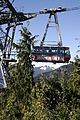
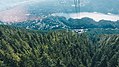
Whistler Blackcomb is a ski resort located in Whistler, British Columbia, Canada. By many measures it is the largest ski resort in North America and has the greatest uphill lift capacity. It features the Peak 2 Peak Gondola for moving between Whistler and Blackcomb mountains at the top. With all of this capacity, Whistler Blackcomb is also often the busiest ski resort, often surpassing 2 million visitors a year.

<span class="mw-page-title-main">Mount Seymour</span> Mountain in British Columbia, Canada

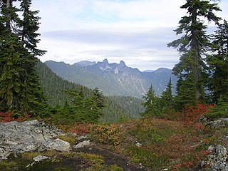
Mount Seymour is a mountain located in Mount Seymour Provincial Park in the District of North Vancouver, British Columbia, Canada. It is a part of the North Shore Mountains, rising to the north from the shores of Burrard Inlet and Indian Arm to a summit of 1,449 m (4,754 ft) above the Indian River and Deep Cove neighbourhoods. Mount Seymour is most commonly identified for its ski area of the same name, and as a popular hiking area. It is named in honour of Frederick Seymour, second governor of the Colony of British Columbia. The name is used to refer to the ridge although the main summit is one of several, and is also known as Third Peak.

<span class="mw-page-title-main">Cypress Provincial Park</span> Provincial park in Greater Vancouver, British Columbia, Canada

Cypress Provincial Park is a provincial park on the North Shore of Metro Vancouver Regional District, British Columbia. The park has two sections: a 21 km2 (8.1 sq mi) southern section which is accessible by road from West Vancouver, and a 9 km2 (3.5 sq mi) northern section which is only accessible by hiking trails. The two sections are linked by a narrow strip of park along the mountainous Howe Sound Crest Trail.

<span class="mw-page-title-main">Mountain Creek</span> Ski area in New Jersey, United States

Mountain Creek is a ski resort in Vernon Township, Sussex County, New Jersey, United States. It is located on New Jersey Route 94 in the New York Metropolitan Area, 47 miles (76 km) from the George Washington Bridge.

<span class="mw-page-title-main">Cypress Mountain Ski Area</span> Ski resort in British Columbia, Canada

Cypress Mountain is a ski area in West Vancouver, British Columbia, Canada, located in the southern section of Cypress Provincial Park, operated under a BC Parks Park Use Permit.

<span class="mw-page-title-main">Sugarloaf (ski resort)</span> Ski resort in Maine, USA

Sugarloaf is a ski area and resort located on Sugarloaf Mountain in Carrabassett Valley, western Maine. It is the second largest ski resort east of the Mississippi in terms of skiable area and snowmaking percentage (95%); its continuous vertical drop of 2,820 feet (860 m) is the second longest in New England. Sugarloaf recorded a total of 352,000 skier visits in the 2005–2006 season, ranking it second among Maine resorts and 11th in New England.

<span class="mw-page-title-main">Sun Peaks Resort</span>

Sun Peaks Resort is an alpine ski resort located in Sun Peaks, British Columbia, Canada, 56 km (35 mi) northeast of Kamloops.

<span class="mw-page-title-main">Big Sky Resort</span> Ski resort in Montana, United States

Big Sky Resort is a ski resort in the western United States, located in southwestern Montana in Madison County. An hour south of Bozeman via U.S. Highway 191 in Big Sky, Montana, it is the second-largest ski resort in the United States by acreage after Palisades Tahoe.

<span class="mw-page-title-main">North Shore Mountains</span> Mountain range in British Columbia, Canada

The North Shore Mountains are a mountain range overlooking Vancouver in British Columbia, Canada. Their southernmost peaks are visible from most areas in Vancouver and form a distinctive backdrop for the city.

<span class="mw-page-title-main">Blue Mountain (ski resort)</span> Alpine ski resort in Ontario, Canada

Blue Mountain is an alpine ski resort in Ontario, Canada, 10 km west of Collingwood. It is situated on a section of the Niagara Escarpment about 1 km (0.6 mi.) from Nottawasaga Bay, and is a major destination for skiers from southern Ontario. The local area forms the newly incorporated town of The Blue Mountains, Ontario. On average, Blue Mountain sells more than 750,000 lift tickets per year, making it the third-busiest ski resort in Canada, after Whistler-Blackcomb in British Columbia and Mont Tremblant in Quebec. It is one of the largest resorts in Ontario and has been extensively built out, featuring 42 runs, 16 chairlifts and 3 freestyle terrains.

<span class="mw-page-title-main">Sugarbush Resort</span> Ski area in Vermont, United States

Sugarbush Resort is a ski resort located in the Mad River valley in Warren, Vermont, owned by Alterra Mountain Company. It is one of the largest ski resorts in New England. The resort encompasses more than 4000 acres (16 km²) total, 484 trail acres (2.34 km²) skiable, 53 miles (85 km) of trails, and 16 ski lifts. Sugarbush has 111 ski trails, 18 additional marked wooded area, substantial off-piste skiing and riding, a summit elevation of 4,083 ft (1,244 m), and a vertical drop of 2,600 feet (790 m), second largest in Vermont after Killington, and the third largest in New England after Killington and Sugarloaf.

<span class="mw-page-title-main">June Mountain ski area</span> Ski area in California, United States

June Mountain ski area is a winter resort in the eastern Sierra Nevada of California, located near June Lake, southeast of Yosemite National Park.

<span class="mw-page-title-main">Park City Mountain Resort</span> Ski resort in Park City, Utah

Park City Mountain Resort (PCMR) is a ski resort in the western United States in Park City, Utah, located 32 miles (51 km) east of Salt Lake City. Park City, as the ski resort and area is known, contains several training courses for the U.S. Ski Team, including slalom and giant slalom runs. During the 2002 Winter Olympics, it hosted the snowboarding events and the men's and women's alpine giant slalom events.

<span class="mw-page-title-main">Crystal Mountain (Washington)</span> Ski area in Washington, United States

Crystal Mountain is a mountain and alpine ski area in eastern Pierce County, Washington, United States, located in the Cascade Range southeast of Seattle. It is the largest ski resort in the state of Washington and lies within the Mount Baker–Snoqualmie National Forest. The resort is accessible from the Seattle–Tacoma metropolitan area via State Route 410.

<span class="mw-page-title-main">Breckenridge Ski Resort</span> Alpine ski resort in Colorado, United States

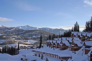
Breckenridge Ski Resort is an alpine ski resort in the western United States, in Breckenridge, Colorado. Recognized for acres of skiable terrain across five mountain peaks, it welcomes thousands of skiers and snowboarders each season. Just west of the Continental Divide in Summit County, it is perennially one of the most visited ski resorts in the western hemisphere. Breckenridge is owned and operated by Vail Resorts, Inc.

<span class="mw-page-title-main">Vail Ski Resort</span> Ski resort in Colorado, USA

Vail Ski Resort is a ski resort in the western United States, located near the town of Vail in Eagle County, Colorado. At 5,289 acres, it is the third-largest single-mountain ski resort in the U.S., behind Big Sky and Park City, featuring seven bowls and intermediate gladed terrain in Blue Sky Basin.

<span class="mw-page-title-main">White Pass Ski Area</span> Ski area in Washington, United States

The White Pass Ski Area is a ski area in the Pacific Northwest of the United States, in the Cascade Range at White Pass in the state of Washington. It is located 53 miles (90 km) west of Yakima on U.S. Route 12, and 53 miles (90 km) east of Morton. As the crow flies, the pass is 25 miles (40 km) southeast of the summit of Mount Rainier and 30 miles (50 km) north of Mount Adams.

<span class="mw-page-title-main">Saddleback Maine (ski resort)</span> Ski area in Sandy River Plantation, Maine

Saddleback Maine is a ski resort located in Sandy River Plantation, near Rangeley, Maine, on the northwestern slopes of Saddleback Mountain. It is the largest independent ski area on the east coast, in terms of number of skiable acres (600). It has (6) lifts, (85%) snowmaking percentage, vertical drop, and skier days. After almost five years of closed doors, Saddleback Mountain was sold to the Arctaris Impact Fund and reopened on December 15, 2020.

Mount Sunapee Resort is a ski area and resort located in Mount Sunapee State Park in Newbury, New Hampshire, United States.

<span class="mw-page-title-main">Sandia Peak Ski Area</span> Ski resort in New Mexico, United States

Sandia Peak Ski Area, originally La Madera Ski Area, is a ski resort located in the Sandia Mountains in northeast Bernalillo County, New Mexico, United States, immediately northeast of the city of Albuquerque. It is part of a Special Use Permit Zone in the Sandia Ranger District of the Cibola National Forest. It is New Mexico's first ski area, opening to skiers in 1936. It features Sandia Peak Tramway, which was until 2010 the longest tramway in the world, and remains the longest in the Americas. The resort includes 35 ski runs and a terrain park, and also serves as a site for summer recreation. It is one of the few ski resorts in the US that can be directly accessed from a major city.

References

  1. About Us | Grouse Mountain - The Peak of Vancouver
  2. See Tramway Titan—Byron Riblet, Wire Rope and Western Resource Towns
  3. Environment CanadaCanadian Climate Normals 1981–2010. Retrieved October 5, 2016.
  4. 1 2 3 "Grouse Mountain Resort's Eye of the Wind begins producing power". Journal of Commerce. 2010-09-22. Retrieved 2011-02-24.
  5. 1 2 "Construction nears completion on mountaintop wind turbine near Vancouver". Journal of Commerce. 2009-11-23. Archived from the original on 2011-07-13. Retrieved 2011-02-24.
  6. "Structural Engineering Company Receives Award of Merit For Innovative Eye of the Wind Turbine". Wind Today. 2011-03-17. Retrieved 2011-04-29.
  7. Sun, Vancouver. (2010-04-13) Dispute keeps Grouse Mountain's wind turbine from turning. Canada.com. Retrieved on 2014-04-12.
  8. Sustainable Saunders » Blog Archive » Grouse Mountain`s Wind Turbine. Blogs.ubc.ca (2010-10-04). Retrieved on 2014-04-12.
  9. Sun, Vancouver. (2010-04-26) Wind turbine threatens birds, bats. Canada.com. Retrieved on 2014-04-12.
  10. "Vancouver's "Eye of the Wind" turbine builds on its wildlife-friendly foundation". 2015-08-10. Retrieved 2017-05-01.
  11. Thomson, Stephen. (2010-09-23) Eye of the Wind turbine starts producing power for Grouse Mountain | Georgia Straight, Vancouver's News & Entertainment Weekly. Straight.com. Retrieved on 2014-04-12.
  12. 1 2 3 "Grouse Mountain 2008 Winter Trail Map" (PDF). Grouse Mountain. Retrieved 2009-09-25.
  13. 1 2 3 "Grouse Mountain Trail Map and Stats". Grouse Mountain. Retrieved 2009-09-25.
  14. "Terrain Parks: A Cut Above The Rest". Grouse Mountain. Retrieved 2009-09-25.
  15. "New Lift In Side Cut Park | Grouse Mountain - The Peak of Vancouver". www.grousemountain.com. Retrieved 2023-12-19.
  16. Tyee Ski Club
  17. "Snowmaking". Grouse Mountain. Retrieved 2009-09-25.
  18. "Snowshoeing". Grouse Mountain. Retrieved 2009-09-25.
  19. Information on the Grouse Grind
  20. 1 2 "Runner summits Grouse Grind a record 13 times". CBC News. 2009-06-23. Retrieved 2009-06-23.
  21. Ebner, Dave (2009-07-25). "Doing the Grouse Grind". Globe and Mail. pp. T1/T4. Retrieved 2009-07-29.
  22. CBC article
  23. Grousegrind statistics
  24. Plana, Vincent (June 24, 2019). "Man climbs Grouse Grind 19 times in 19 hours to break record". Daily Hive. Retrieved 2019-06-24.
  25. 1 2 "Grouse Grind Stats - Grouse Mountain - The Peak of Vancouver". grousemountain.com. Retrieved 29 June 2016.
  26. Grouse Grinder breaks record for charity
  27. McMartin, Pete (2009-06-23). "Tackling Grouse Grind 13 times in a day is an uphill battle". Vancouver Sun. pp. A4. Archived from the original on 2009-08-12. Retrieved 2009-06-23.
  28. Jones, Tim (2005-03-18). "Grouse Grind open for hiking". North Shore News.
  29. "Vancouver Sun - Local Entertainment". mjq.net. Retrieved 29 June 2016.
  30. Gradnitzer, Louisa; Pittson, Todd (1999). X marks the spot: on location with the X-files . Arsenal Pulp Press. p.  66. ISBN   1-55152-066-4.
  31. "Nelly Furtado's 'Spirit Indestructible' Video - Watch Now!". terra.com. 2012-07-19. Archived from the original on 2014-12-20. Retrieved 2012-08-05.
  32. "American Pie Presents: The Book of Love filming locations — Movie Maps". moviemaps.org. Retrieved 29 June 2016.