Arrow Lakes Provincial Park is a provincial park in British Columbia, Canada.
Boundary Creek Provincial Park is a provincial park in British Columbia, Canada located south of Greenwood BC in that province's Boundary Country, adjacent to BC Highway 3. The eponymous Boundary Creek flows through the park.
Blue Earth Lake Provincial Park is a provincial park in the Upper Hat Creek area at the south end of the Cornwall Hills, just northwest of Ashcroft, British Columbia, Canada.
Victor Lake Provincial Park is a provincial park in British Columbia, Canada, located southwest of Revelstoke to the north of Three Valley Lake.
Columbia Lake Provincial Park is a provincial park in British Columbia, Canada, located on the northeast shore of Columbia Lake south of the town of Invermere. The park was established in 1988, comprising approximately 260 hectares. Its boundary was expanded in 2004, the total now comprising approximately 290 hectares, 275 hectares of which is upland, 15 hectares of which is foreshore.
Christina Lake Provincial Park is a provincial park in British Columbia, Canada. The lake it's on, Christina Lake, is renowned as the warmest lake in Canada.
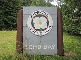
Echo Bay Marine Provincial Park is a provincial park in British Columbia, Canada, established in 1971 and containing 1.5 hectares. It is located at the bay of the same name, offshore from the community of the same name, which is the location of the Simoom Sound post office and is on the west side of Gilford Island.
Ellison Provincial Park is a provincial park in British Columbia, Canada, located on the east side of Okanagan Lake to the south of the city of Vernon. The park contains approximately 219 hectares (2.19 km2) of land, 200 ha. of it upland, 19 ha. of it foreshore.
English Lake Provincial Park is a provincial park in British Columbia, Canada. Located near Revelstoke, British Columbia, English Lake Provincial Park has an area of 337 hectares.
Kekuli Bay Provincial Park, formerly Kalamalka West Provincial Park, is a provincial park in British Columbia, Canada, located on the west shore of Kalamalka Lake on BC Highway 97 south of Vernon. The lake is popular for waterskiing and boating, and the park includes a boat launch, as well as a campground with a view of the lake. The park was established in 1990. Its size is about 57 hectares.
Kingfisher Creek Provincial Park is a provincial park in British Columbia, Canada located 15 km southeast of Sicamous and west of Mabel Lake in the Monashee Mountains. The park is 440 hectares and was created to enhance the viability of the Kingfisher Creek Ecological Preserve.
Mabel Lake Provincial Park is a provincial park in the Monashee Mountains of British Columbia, Canada, located on the east side of Mabel Lake, which is part of the Shuswap River system. Created on December 21, 1972, at approximately 182 hectares, the park was expanded in 2000 to approximately 187 hectares.

Monashee Provincial Park is a provincial park located just outside of Cherryville, British Columbia, Canada. It is located in the central Monashee Mountains between the Arrow Lakes and the upper Shuswap River drainage, just east of Sugar Lake. It is a remote grizzly habitat that is a walk-in only. Mount Fosthall is the highest peak in the area and can be hiked in a day. In addition to hiking and alpinism other activities include fishing.
Monte Lake Provincial Park is a provincial park in British Columbia, Canada, located on the east side of Monte Lake and to the south of the community of Monte Lake, British Columbia which is at the north end of the lake. About five hectares in size, it protects an area of Ponderosa pine and grasslands.
Mount Griffin Provincial Park is a provincial park in British Columbia, Canada, located southwest of Three Valley Gap.
Nimpkish Lake Provincial Park is a provincial park on northern Vancouver Island, British Columbia, Canada on Vancouver Island. The park is 3,949 ha. in area and was established on 1995. It is 32 km south of Port McNeill and on the southwest side of Nimpkish Lake. Primary access is by boat launch, though radio-controlled logging roads lead to the edge of the park. Western Forest Products in Woss, British Columbia should be contacted for road advisories. The park is in the traditional territory of the Namgis First Nation.
Shuswap Lake Marine Provincial Park is a provincial park in British Columbia, Canada, comprising 894 ha. The Park has a variety of amenities including boat launch ramps, picnic areas, and 27 campsites around the perimeter of Shuswap Lake. The lake's name and that of the surrounding Shuswap Country is from the Shuswap people (Secwepemc), the most northern of the Salishan speaking people.
Skookumchuck Rapids Provincial Park is a provincial park in British Columbia, Canada, located on the Shuswap River just below the outlet of Mabel Lake. This park was established as a result of the Okanagan-Shuswap Land and Resource Management Plan.
Tunkwa Provincial Park is a provincial park on the northern Thompson Plateau in south central British Columbia, Canada. The locality is by road about 16 kilometres (10 mi) north of Logan Lake and 27 kilometres (17 mi) south of Savona.

The Seton Lake First Nation, a.k.a. the Seton Lake Indian Band, is a First Nations government located in the Central Interior-Fraser Canyon region of the Canadian province of British Columbia. It is a member of the Lillooet Tribal Council, which is the largest grouping of band governments of the St'at'imc people. Other St'at'imc governments include the smaller In-SHUCK-ch Nation on the lower Lillooet River to the southwest, and the independent N'quatqua First Nation at the farther end of Anderson Lake from Seton Portage, which is the location of three of the band's reserve communities.
