Lumby, British Columbia

Last updated

Lumby
The Corporation Of Lumby [1]
Motto: 
De porta usque ad Monashee (The Gateway to the Monashee)
Canada British Columbia location map 2.svg
Red pog.svg
Lumby
Location of Lumby
Canada location map 2.svg
Red pog.svg
Lumby
Lumby (Canada)
Coordinates: 50°14′58″N118°57′56″W / 50.24944°N 118.96556°W / 50.24944; -118.96556
CountryCanada
Province British Columbia
Regional District North Okanagan
Incorporated (Village)1956
Government
[2]
  MayorKevin Acton
  CouncillorGeoff Bevan
  CouncillorSherry Kineshanko
  CouncillorLori Mindnich
  CouncillorRandal Ostafichuk
Area
   Village 5.27 km2 (2.03 sq mi)
Elevation
500 m (1,600 ft)
Population
 (2019)
   Village 2,000
   Urban
3,500
Time zone UTC−08:00 (PST)
  Summer (DST) UTC−07:00 (PDT)
Postal code span
V0E
Area code 250 / 778 / 236
Highways BC-6.svg Hwy 6
Website Official website

Lumby is a small community of 2,063 people, located near the edge of the Monashee Mountains. [3] It is mainly a logging, manufacturing and agriculture community. [4]

Contents

The village is home to a network of trails along the creek beds, known collectively as the Salmon Trail. [5] [6]

Hang gliding and paragliding are very popular in Lumby. The village has hosted many national and international events, usually taking place at nearby Cooper Mountain. [7]

Schools administered by School District 22 Vernon in Lumby include Charles Bloom Secondary School, Crossroads Alternate School and J W Inglis Elementary School. [8]

The community was also home to the Lumby Fighting Saints of the now defunct WHA Junior West Hockey League.

Some of Lumby's prominent employers include: Tolko Industries, Rouck Brothers Sawmill, Valley Pallet Plus, [9] Super A Grocery, Irly Building Centres, Mac's Convenience Stores, Fields, Lumby Hotel and Blue Ox Pub. [10]

Annually, the "Lumby Days" family fair takes place in the beginning of summer, attracting many people from around the valley.

The Village also hosts a winter outhouse race featuring creative entries of three sided outhouses mounted on skis.

On 8 October 2014 a WWII-era Japanese balloon bomb was discovered in the mountains near Lumby by forestry workers. The next day, they reported it to the RCMP. It was then disposed of on site using explosives, as it was too dangerous to move it. All of this happening 70 years after it had been launched. [11]

Lumby had been known as White Valley but one year after his death, the town name was changed to honour Moses Lumby (1842–93). He had a varied career including serving as Government Agent in Vernon, British Columbia and vice-president of the Shuswap and Okanagan Railway. [12] :157

Climate

Lumby has a humid continental climate with hot summers days and cool nights. Spring and fall are the driest seasons, and summer and winter are the wettest seasons. Fog often sets in during the winter, and can last for days at a time. Lumby is wetter and cooler than Vernon, but is still dry enough to contain natural grasslands, especially on south facing slopes.

During the summer months, Lumby has one of the highest diurnal temperature variations in Canada. The daily temperature swing of 20.1 °C (36.2 °F) in August is only exceeded by Beaverdell.

Lumby is at a transition point between the semi-arid dry belt to the west and the interior rainforest to the east. Thus, both wet and dry vegetation are common in Lumby.

Weather facts:

Climate data for Lumby
MonthJanFebMarAprMayJunJulAugSepOctNovDecYear
Record high °C (°F)11.7
(53.1)
12.2
(54.0)
22.2
(72.0)
27.5
(81.5)
33.0
(91.4)
37.0
(98.6)
39.0
(102.2)
39.0
(102.2)
35.5
(95.9)
25.0
(77.0)
16.5
(61.7)
10.0
(50.0)
39.0
(102.2)
Mean daily maximum °C (°F)−1.2
(29.8)
2.8
(37.0)
8.3
(46.9)
15.3
(59.5)
19.4
(66.9)
23.4
(74.1)
28.0
(82.4)
27.5
(81.5)
21.7
(71.1)
12.4
(54.3)
4.2
(39.6)
−0.6
(30.9)
13.4
(56.1)
Daily mean °C (°F)−4.8
(23.4)
−2.6
(27.3)
2.7
(36.9)
7.7
(45.9)
11.6
(52.9)
15.4
(59.7)
18.4
(65.1)
17.5
(63.5)
12.9
(55.2)
6.2
(43.2)
0.5
(32.9)
−4.4
(24.1)
6.8
(44.2)
Mean daily minimum °C (°F)−8.4
(16.9)
−7.9
(17.8)
−3.0
(26.6)
0.1
(32.2)
3.8
(38.8)
7.3
(45.1)
8.7
(47.7)
7.4
(45.3)
4.1
(39.4)
−0.1
(31.8)
−3.2
(26.2)
−8.1
(17.4)
0.1
(32.2)
Record low °C (°F)−38.5
(−37.3)
−34.0
(−29.2)
−25.6
(−14.1)
−11.1
(12.0)
−5.0
(23.0)
−1.7
(28.9)
0.0
(32.0)
−1.5
(29.3)
−6.0
(21.2)
−12.5
(9.5)
−28.5
(−19.3)
−32.8
(−27.0)
−38.5
(−37.3)
Average precipitation mm (inches)52.7
(2.07)
22.1
(0.87)
28.5
(1.12)
27.9
(1.10)
56.0
(2.20)
59.3
(2.33)
35.9
(1.41)
34.5
(1.36)
44.2
(1.74)
47.0
(1.85)
54.3
(2.14)
46.3
(1.82)
508.7
(20.03)
Average rainfall mm (inches)9.2
(0.36)
8.8
(0.35)
17.5
(0.69)
25.8
(1.02)
55.9
(2.20)
59.3
(2.33)
35.9
(1.41)
34.5
(1.36)
44.2
(1.74)
46.2
(1.82)
29.5
(1.16)
6.9
(0.27)
373.7
(14.71)
Average snowfall cm (inches)43.5
(17.1)
13.3
(5.2)
11.0
(4.3)
2.1
(0.8)
0.2
(0.1)
0.0
(0.0)
0.0
(0.0)
0.0
(0.0)
0.0
(0.0)
0.8
(0.3)
24.7
(9.7)
39.4
(15.5)
135.0
(53.1)
Average precipitation days (≥ 0.2 mm)16.910.014.312.215.814.99.09.110.915.115.914.8158.8
Average rainy days (≥ 0.2 mm)5.44.810.311.715.814.99.09.110.914.910.83.8121.4
Average snowy days (≥ 0.2 cm)12.86.45.10.70.30.00.00.00.00.36.811.744.1
Source: [13]

Demographics

In the 2021 Census of Population conducted by Statistics Canada, Lumby had a population of 2,063 living in 836 of its 861 total private dwellings, a change of

Religion

According to the 2021 census, religious groups in Lumby included: [14]

Related Research Articles

<span class="mw-page-title-main">Vernon, British Columbia</span> City in British Columbia, Canada

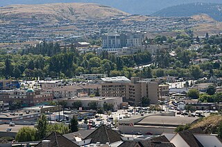
Vernon is a city in the Okanagan region of the Southern Interior of British Columbia, Canada. It is 440 km (270 mi) northeast of Vancouver. Named after Forbes George Vernon, a former MLA of British Columbia who helped establish the Coldstream Ranch in nearby Coldstream, the City of Vernon was incorporated on 30 December 1892. The City of Vernon has a population of 40,000 (2013), while its metropolitan region, Greater Vernon, had a population of 58,584 as of the 2011 Canadian census. With this population, Vernon is the largest city in the North Okanagan Regional District. A resident of Vernon is called a "Vernonite".

<span class="mw-page-title-main">Penticton</span> City in British Columbia, Canada

Penticton is a city in the Okanagan Valley of the Southern Interior of British Columbia, Canada, situated between Okanagan and Skaha lakes. In the 2016 Canadian Census, its population was 33,761, while its census agglomeration population was 43,432.

<span class="mw-page-title-main">Cranbrook, British Columbia</span> City in British Columbia, Canada

Cranbrook is a city in southeast British Columbia, Canada, located approximately 10 km southwest of the confluence of the Kootenay River and the St. Mary's River. It is the largest urban centre in the region known as the East Kootenay. As of 2016, Cranbrook's population is 20,499 with a census agglomeration population of 27,040. It is the location of the headquarters of the Regional District of East Kootenay and also the location of the regional headquarters of various provincial ministries and agencies, notably the Rocky Mountain Forest District.

<span class="mw-page-title-main">McBride, British Columbia</span> Village in British Columbia, Canada

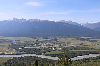
McBride is a village in the Robson Valley region of British Columbia, Canada. The village is located 210 km (130 mi) southeast of Prince George, British Columbia, and 166 km (103 mi) west of Jasper, Alberta. Incorporated in 1932, McBride is located in the Robson Valley surrounded by the Rocky Mountains and Cariboo Ranges.

<span class="mw-page-title-main">Okanagan</span> Region of British Columbia, Canada

The Okanagan, also called the Okanagan Valley and sometimes the Okanagan Country, is a region in the Canadian province of British Columbia defined by the basin of Okanagan Lake and the Canadian portion of the Okanagan River. It is part of the Okanagan Country, extending into the United States as Okanogan County in north-central Washington. According to the 2016 Canadian census, the region's population is 362,258. The largest populated cities are Kelowna, Penticton, Vernon, and West Kelowna.

<span class="mw-page-title-main">Osoyoos</span> Town in British Columbia, Canada

Osoyoos is the southernmost town in the Okanagan Valley in British Columbia between Penticton and Omak. The town is 3.6 km (2.2 mi) north of the United States border with Washington state and is adjacent to the Osoyoos Indian reserve. The origin of the name Osoyoos was the word sw̓iw̓s meaning "narrowing of the waters" in the local Okanagan language (Syilx'tsn). The "O-" prefix is not indigenous in origin and was attached by settler-promoters wanting to harmonize the name with other place names beginning with O in the Okanagan region. There is one local newspaper, the Osoyoos Times.

<span class="mw-page-title-main">Hope, British Columbia</span> District municipality in British Columbia, Canada

Hope is a district municipality at the confluence of the Fraser and Coquihalla rivers in the province of British Columbia, Canada. Hope is at the eastern end of both the Fraser Valley and the Lower Mainland region, and is at the southern end of the Fraser Canyon. To the east, over the Cascade Mountains, is the Interior region, beginning with the Similkameen Country on the farther side of the Allison Pass in Manning Park. Located 154 kilometres (96 mi) east of Vancouver, Hope is at the southern terminus of the Coquihalla Highway and the western terminus of the Crowsnest Highway, locally known as the Hope-Princeton, where they merge with the Trans-Canada Highway. Hope is at the eastern terminus of Highway 7. As it lies at the eastern end of the Fraser Valley in the windward Cascade foothills, the town gets very high amounts of rain and cloud cover – particularly throughout the autumn and winter.

<span class="mw-page-title-main">Burns Lake</span> Village in British Columbia, Canada

Burns Lake is a rural village in the North-western-Central Interior of British Columbia, Canada, incorporated in 1923. The village had a population of 1,659 as of the 2021 Census.

<span class="mw-page-title-main">Lytton, British Columbia</span> Village in British Columbia, Canada

Lytton is a village of about 250 residents in southern British Columbia, Canada, on the east side of the Fraser River and primarily the south side of the Thompson River, where it flows southwesterly into the Fraser. The community includes the Village of Lytton and the surrounding community of the Lytton First Nation, whose name for the place is Camchin, also spelled Kumsheen.

<span class="mw-page-title-main">Oliver, British Columbia</span> Town in British Columbia, Canada

Oliver is a town near the south end of the Okanagan Valley in the Southern Interior of British Columbia, Canada, with a population of nearly 5,000 people. It is located along the Okanagan River by Tuc-el-nuit Lake between Osoyoos and Okanagan Falls, and is labelled as the Wine Capital of Canada by Tourism British Columbia. It was once "The Home of the Cantaloupe" as well as the "Home of the International Horseshow."

<span class="mw-page-title-main">Duncan, British Columbia</span> City in British Columbia, Canada

Duncan is a city on southern Vancouver Island in British Columbia, Canada. It is the smallest city by area in Canada. It was incorporated in 1912.

<span class="mw-page-title-main">Summerland, British Columbia</span> Town in British Columbia, Canada

Summerland is a district municipality on the west side of Okanagan Lake in the interior of British Columbia, Canada. The district is between Peachland to the north and Penticton to the south. The largest centre in the region is Kelowna, approximately 50 km (31 mi) to the north, and Vancouver is approximately 425 km (264 mi) away to the west. The district is famous for "Bottleneck drive", a system of roads connecting various wineries.

<span class="mw-page-title-main">Langford, British Columbia</span> City in British Columbia, Canada

Langford is a city on southern Vancouver Island in the province of British Columbia, Canada. Langford is one of the 13 component municipalities of Greater Victoria and is within the Capital Regional District. Langford was incorporated in 1992 and has a population of over 40,000 people. Its municipal neighbours are Colwood to the southeast, Highlands to the north, Metchosin to the southwest, and View Royal to the northeast.

<span class="mw-page-title-main">Gold River, British Columbia</span> Village in British Columbia, Canada

Gold River is a village municipality located close to the geographic centre of Vancouver Island in British Columbia, Canada. In terms of the Island's human geography it is considered to be part of the "North Island", even though it technically is on the Island's west coast.

<span class="mw-page-title-main">Port Hardy</span> District municipality in British Columbia, Canada

Port Hardy is a district municipality in British Columbia, Canada located on the north-east end of Vancouver Island. Port Hardy has a population of 3,902 as of the 2021 census.

<span class="mw-page-title-main">Barriere, British Columbia</span> District municipality in British Columbia, Canada

Barriere is a district municipality in central British Columbia, Canada, located 66 km (41 mi) north of the larger city of Kamloops on Highway 5. It is situated at the confluence of the Barrière River and North Thompson Rivers in the Central North Thompson Valley.

<span class="mw-page-title-main">Regional District of North Okanagan</span> Regional district in British Columbia, Canada

The Regional District of North Okanagan (RDNO) is a regional district in the Canadian province of British Columbia, Canada. The Canada 2011 Census population was 81,237. The land area is 7,512.58 km². The regional district's head office is in the district municipality of Coldstream, although the largest population centre is its immediate neighbour, the city of Vernon.

<span class="mw-page-title-main">Midway, British Columbia</span> Village in British Columbia, Canada

Midway is in the West Kootenay region of south central British Columbia. The village lies 13 kilometres (8 mi) west of Greenwood and 51 kilometres (32 mi) east of Osoyoos along Highway 3.

<span class="mw-page-title-main">Coldstream, British Columbia</span> District municipality in British Columbia, Canada

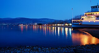
Coldstream is a district municipality in British Columbia, Canada, located at the northern end of Kalamalka Lake in the Okanagan Valley. Incorporated on December 21, 1906, Coldstream celebrated its centennial in 2006. The municipality is directly southeast of Vernon and is considered part of Greater Vernon. It is a member municipality of, and also the location of the head offices, of the Regional District of North Okanagan.

Spallumcheen is a district municipality in the Canadian province of British Columbia. Located in the Okanagan region between Vernon and Enderby, the township had a population of 5,055 and land area of 255.77 square kilometres (98.75 sq mi) in the Canada 2011 Census. The district, whose official name is the Township of Spallumcheen and which is the oldest rural municipality in the British Columbia Interior, consists primarily of agricultural land surrounding the separately incorporated City of Armstrong. Both Spallumcheen and Armstrong are member municipalities of the Regional District of North Okanagan.

References

  1. "British Columbia Regional Districts, Municipalities, Corporate Name, Date of Incorporation and Postal Address" (XLS). British Columbia Ministry of Communities, Sport and Cultural Development. Archived from the original on 13 July 2014. Retrieved 2 November 2014.
  2. Councillors | Lumby
  3. 1 2 "Population and dwelling counts: Canada, provinces and territories, and census subdivisions (municipalities), British Columbia". Statistics Canada. 9 February 2022. Retrieved 20 February 2022.
  4. "Lumby and District Chamber of Commerce". Archived from the original on 10 October 2006.
  5. "Lumby Weyerhaeuser Salmon Trail".[ dead link ]
  6. "Lumby Transportation and Trails Master Plan" (PDF). Archived from the original (PDF) on 6 July 2011.
  7. "The Lumby Airforce". The Lumby Airforce. Archived from the original on 14 October 2013. Retrieved 24 November 2013.
  8. "School District No. 22 Vernon – Schools in the District". Sd22.bc.ca. 4 September 2013. Archived from the original on 15 December 2012. Retrieved 24 November 2013.
  9. Valley Pallet Plus
  10. "Major Employers in Lumby and Area". Archived from the original on 25 March 2009.
  11. "WWI era balloon bomb in BC blown to smithereens". Globalnews.ca. The Canadian Press. 10 October 2014. Retrieved 15 March 2015.
  12. Akrigg, G.P.V.; Akrigg, Helen B. (1986), British Columbia Place Names (3rd, 1997 ed.), Vancouver: UBC Press, ISBN   0-7748-0636-2
  13. "Climate Normals and Averages Lumby". Environment Canada. Archived from the original (CSV) on 13 March 2020. Retrieved 10 May 2016.
  14. Government of Canada, Statistics Canada (26 October 2022). "Census Profile, 2021 Census of Population". www12.statcan.gc.ca. Retrieved 12 March 2023.