Kanaka Creek Regional Park

Last updated
Kanaka Creek Regional Park
Kanaka Creek Oxbow - panoramio.jpg
Kanaka Creek Regional Park
Type Regional Park
Location Maple Ridge
Nearest city Maple Ridge, British Columbia, Canada
Coordinates 49°12′38″N122°31′29″W / 49.2106°N 122.5247°W / 49.2106; -122.5247
Area400 hectares (990 acres)
EstablishedPlants and Wildlife
Operated by Metro Vancouver Regional District
Website metrovancouver.org/services/regional-parks/park/kanaka-creek-regional-park

Kanaka Creek Regional Park is a regional park of the Greater Vancouver Regional District, located in the city of Maple Ridge, British Columbia, flanking both sides of Kanaka Creek from its confluence with the Fraser River just east of Haney and extending approximately 11 km (7 mi) up the creek to just south of the community of Webster's Corners. The Maple Ridge Fairgrounds are just east of the lower regions of the park, beyond them is the community of Albion. Derby Reach Regional Park is just across the Fraser in Langley.

Contents

A variety of plants and animals can be located in all 3 areas of the park and it is a popular spot for both Black Bear and Salmon populations. [1] Kanaka Creek Regional Park has a rich history- the first purchase of land for the park by the City of Maple Ridge occurred in the late 1970s, [2] [3] and the land is the traditional unceded territory of the Katzie, Kwantlen, Matsqui, Musqueam, Semiahmoo, and Tseil-Waututh peoples. [1] Recently, misuse of the land has negatively changed parts of the park. [1] To fix this issue, Metro Vancouver Regional Parks implemented a 20 year management plan in 2004 with the assistance of the Katzie First Nation among other groups, [4] and the University of Victoria (UVIC) completed a restoration project in areas of the park in 2022. [1]

Recreation

Kanaka Creek is widely recognized for its natural beauty, as well as recreational appeal. According to a local newspaper, the Daily Hive, Kanaka is the 8th most popular park in metro Vancouver, with 610,500 visitors in 2022. [5] The park features walking, hiking, and biking trails [6] publicly available to anyone who wants to use them.  Along these walks there is plenty of flora and fauna to view. The park also has a lake in which visitors can fish, or canoe . [6] The park is wheelchair accessible, and equipped with parking and public washrooms. [6]

The 400 ha. park has three main areas. The Riverfront area adjacent to the Fraser and BC Hwy 7 has picnic tables and a boat-launch, suitable for launching canoes and kayaks for navigating the slow-moving waters of Kanaka Creek up as far as the 240th Street bridge. The Riverfront Trail winds along this stretch of the creek and has a number of three-story wooden viewing towers. Above 240th Street the stream is shallower and full of snags and not suitable for boating. Above that a popular swimming hole with slickrock slides is at Cliff Falls. There are twin falls on Kanaka Creek, one on each of its upper fork. Much of the upper area of the park is heavily forested, though hiking along the creek beds is feasible and a number of wooden walkways through the forest and along the creek have been established in the area.

Landscape

Kanaka Creek Regional Park (KCRP) is an ecological region consisting of many diverse ecosystems and wildlife. With a general landscape of Fraser River frontage, steep canyons, marshland fields, floodplains, riparian forests, and upland forests that provide habitat for native plants and wildlife. [1] [4] Currently, the KCRP land base includes 413 hectares with water flow from Blue Mountain to the Fraser River. [4] KCRP is split among four main sections: the riverfront, lower reach & fish fence, mid reach & cliff falls, and the upper reach and hatchery. [1] Surrounding these areas, the upper reach consists of working agriculture and woodlands, while the lower reach is bounded by residential neighbourhoods. [1] This diverse landscape also offers many recreation opportunities, including places to walk, hike, bird watch, and picnic. [1] Furthermore, KCRP's landscape is embedded with history and spiritual significance throughout over nine thousand years of use. [1] This territory is shared among the Kwantlen, Katzie, Matsqui, Musqueam, Semiahmoo, and Tsleil-Waututh nations. [1]

Plants and wildlife

Plants

Kanaka Creek is the home of a variety of plant species. Most of the park is considered a Coastal Douglas Fir biogeoclimatic zone- however, the conditions change slightly along the creek path. [7]

The park is home to over 7 tree species including the Douglas fir, western red cedar, and bigleaf maple. The more humid areas of the park host around 6 species of fern such as the lady fern and spiny wood fern. Common BC native shrubs are also located here like the salmonberry and blue elderberry and over 40 species of native flowers like Pacific bleeding hearts and false lilies of the valley. Toxic plants like skunk cabbage can also be spotted in the park. [7] [8] [9]

Wildlife

"Black bear" by CaliforniaDFW Black Bear holding salmon.jpg
"Black bear" by CaliforniaDFW

Wildlife can be considered a main attraction for Kanaka Creek which has both an active black bear and salmon population. Black bears regularly occupy Kanaka Creek as it provides a connection to the Fraser River and mature forests which are both important to the well being of the local black bear population. [1] The spawning salmon that pass through Kanaka Creek are also a staple food source. Salmon spend time in the area throughout the year in the creek and in the Bell-Irving Hatchery. The hatchery is located in the park and aims to educate the public about salmon conservation in the creek. Both the hatchery and waterways see Chum, Pink and Coho Salmon. [1] [10] Large mammals found in the park include the cougar, bobcat, coyote, red fox], and deer. Both small aquatic and on-land mammals also reside here including the river otter and striped skunk. The park has a wide variety of shrews, bats, voles, and squirrels. Amphibians and reptiles also can be located including frogs, toads, salamanders, and snakes. Birds are the most abundant species at Kanaka Creek with over 130 species that have been spotted. [10]

Species at risk

"Northern Red-legged Frog" by born1945 Northern-Red Legged Frog.jpg
"Northern Red-legged Frog" by born1945

Under the Forest and Range Practices Act, the coastal tailed frog, northern red-legged frog, and Pacific water shrew are considered 'species at risk' and are all found in the park. [11] Both the coastal tailed frog and the northern red-legged frog can be found in shaded small, slow streams. Their habitats are regularly disturbed by forest harvesting and road construction. The Pacific water shrew can be found in forests along slow-moving streams however the species is endangered and considered extremely rare. This shrew species is affected by any disturbances in its wetland habitat. [11] Under the Conservation Status Rank List of British Columbia, the northern red-legged frog is on the Blue List (species of special concern), the coastal tailed frog is on the Yellow List (least risk of being lost), and the Pacific water shrew is on the Red List (risk of being lost). [12] [13]

History

South Kanaka Creek Falls, 1915 South Kanaka Creek Falls, Websters Corners, British Columbia (HS85-10-30630).jpg
South Kanaka Creek Falls, 1915

In the late 1970s, the City of Maple Ridge started buying out private properties within the proposed borders of the park, [2] which lead to pushback from those who had property in the watershed. [3] Following this, an agreement was made in 1981 that would protect as much of the watershed as possible and uproot as few residents as possible, leading to the linear shape [4] of the park that fulfilled the original goal of creating an area for recreation while protecting the natural landscape. [3] The final land purchase and addition to the park was made in 1993. [2] [3]

Indigenous history

Kanaka Creek Regional Park is part of the Katzie, Kwantlen, Matsqui, Musqueam, Semiahmoo, and Tseil-Waututh peoples unceded traditional territory. [3] The populations native to Kanaka were ravaged by a plague in 1750, and much of the surviving populous was taken out by another wave of disease in the early 1800s. [2] The current name Kanaka is from the Hawaiian and Pacific Islander population who lived there in the 1850s. [2] The word Kanaka is Hawaiian slang for worker, referring to the primarily working class Hawaiian families occupying the area. [2]

Human impact

Issues

As the landscape changed due to active logging by the Abernethy and Lougheed Lumber Company in the 1920s, the park now lacks a sizeable amount of original old growth forest, which has resulted in significant damage to the hydrological regimes and surrounding vegetation. [1] [4] As a result, species are facing habitat loss with a greater risk of becoming threatened, endangered, or extirpated. [4]

The creek itself is also undergoing increasing water quality problems resulting from rapidly growing urbanization, eutrophication, agricultural and industrial activities, and other human impacts. [4] In addition, organic contamination is considered to be one of the main driving factors in the degradation of water quality in Kanaka Creek. [4] Due to approximately 900 septic tanks in the watershed as well as contributing factors of herbicide and pesticide washing into the creek, massive loss of fish habitat is impacting ecosystems. [4]

Furthermore, other issues arise due to clay deposits near the surface preventing the absorption of surface runoff during the stormy seasons. [4] This is triggering flooding in the lower reaches, which is causing erosion and siltation and flushing out fish stocks. [4] Due to these issues, the creek was designated as a sensitive habitat under the BC Provincial Fish Protection Act, which protects Pacific salmon species such as chum, coho, and pink salmon. [1]

Groups involved

A number of groups have interest in this park. Kanaka Creek Regional Park is operated by Metro Vancouver Regional Parks, [4] [1] and hosts the Kanaka Education and Environmental Partnership Society (KEEPS), which operates the Bell-Irving Hatchery and the Kanaka Creek Watershed Stewardship Centre. [14] KEEPS holds events in the park like Return of the Salmon day and educational open houses for free. [15] They also host paid educational programs in the park and can visit classrooms as well. [16] The Katzie First Nation was also involved in the creation of the current management plan. [4]

Management plan

Alongside the Katzie First Nation, KEEPS, the Alouette Field Naturalists, and the City of Maple Ridge, Metro Vancouver Regional Parks (as the operator of the park) created a plan for the park in 2004. [4] It was set to remain the management plan for 20 years. [4] The plan considers human intrusion through unauthorized trails and dumping, visitors in the park, the status of species in the park, areas of the park susceptible to damage, resources in the park, and the location of the park in consideration to other greenways in the area. [4] Goals of this management strategy include protecting all ecosystems in the park from downgrading, and maintaining the recreational areas of the park by promoting activities that do not harm the area. [4] Another goal is the improvement of stormwater management, to improve the issue of rainwater runoff, locals and government representatives implemented an Integrated Stormwater Management Plan (ISMP) in hopes of improving drainage and reducing flooding. [17] The plan also seeks to maintain good communication with all groups involved in the area, provide educational opportunities and information about the park, as well as to maintain the safety of the park. [4] More goals include enhancing native plant community recovery and development by planting at least ten different native species by November 2021, providing additional cover of salmonberry and snowberry to support ecosystems, and planting low-level species to allow sunlight into the site. [1]

Restoration efforts

Kanaka Creek Regional Park underwent a successful restoration project done by the University of Victoria in 2022 which included planting a number of native plants to close off an area with unauthorized human activity. [1] This includes unsanctioned trails being created and the unauthorized construction of bike jumps off trail along with other misuse of the park, which lead to a loss of plant life. [1] As part of the project, new fences have been implemented in these areas to discourage the misuse. [1] After the project was completed, the team recommended that there be more work done to educate the public on proper trail usage to maintain the health of the park. [1]

See also

Related Research Articles

<span class="mw-page-title-main">Lower Mainland</span> Region in British Columbia, Canada

The Lower Mainland is a geographic and cultural region of the mainland coast of British Columbia that generally comprises the regional districts of Metro Vancouver and the Fraser Valley. Home to approximately 3.05 million people as of the 2021 Canadian census, the Lower Mainland contains sixteen of the province's 30 most populous municipalities and approximately 60% of the province's total population.

Kanaka may refer to:

<span class="mw-page-title-main">Fraser River</span> River in British Columbia, Canada

The Fraser River is the longest river within British Columbia, Canada, rising at Fraser Pass near Blackrock Mountain in the Rocky Mountains and flowing for 1,375 kilometres (854 mi), into the Strait of Georgia just south of the City of Vancouver. The river's annual discharge at its mouth is 112 cubic kilometres (27 cu mi) or 3,550 cubic metres per second (125,000 cu ft/s), and each year it discharges about 20 million tons of sediment into the ocean.

<span class="mw-page-title-main">Maple Ridge, British Columbia</span> City in British Columbia, Canada

Maple Ridge is a city in British Columbia, Canada. It is located in the northeastern section of Greater Vancouver between the Fraser River and the Golden Ears, which is a group of mountain summits which are the southernmost of the Garibaldi Ranges of the Coast Mountains. Maple Ridge's population in 2021 was 90,990. Its downtown core area was once known as Haney.

<span class="mw-page-title-main">Coquitlam River</span> River in British Columbia, Canada

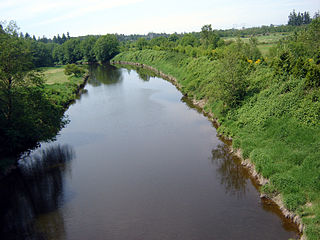
The Coquitlam River is a tributary of the Fraser River in the Canadian province of British Columbia. The river's name comes from the word Kʷikʷəƛ̓əm which translates to "Red fish up the river". The name is a reference to a sockeye salmon species that once occupied the river's waters.

<span class="mw-page-title-main">Pinecone Burke Provincial Park</span> Provincial park in British Columbia, Canada


Pinecone Burke Provincial Park is a provincial park in British Columbia, Canada. It extends from the southwest corner of Garibaldi Provincial Park, west of Pitt Lake and Pitt River to include Burke Mountain in the City of Coquitlam. Most of the park is unserviced wilderness with very rough trails such as the Fools Gold Trail in the Boise Valley. There is canoe access to Widgeon Slough and from there hiking trails that lead to Widgeon Lake, and a network of old logging roads, hiking and mountain biking trails on Burke Mountain. Visitors can also use the park for camping, backcountry skiing, and snowshoeing.

<span class="mw-page-title-main">Golden Ears Provincial Park</span> Provincial park in British Columbia, Canada

Golden Ears Provincial Park is a 555.9 square kilometres (214.6 sq mi) provincial park in British Columbia, Canada. It is named after the prominent twin peaks, which are commonly referred to as Golden Ears. The park was originally part of Garibaldi Provincial Park but was split off as a separate park in 1967. The area was logged extensively in the 1920s by the Lougheed and Abernathy Logging Company. Many recreational attractions are found within the park. Golden Ears Provincial Park is a protected area that contains many endangered species of flora and fauna.

<span class="mw-page-title-main">Sand Ridge State Forest</span> State forest in Illinois, United States

Sand Ridge State Forest is a conservation area located in the U.S. state of Illinois. Containing 7,200 acres (2,900 ha), it is the largest state forest in Illinois. It is located in northern Mason County. The nearest town is Manito, Illinois, and the nearest numbered highway is U.S. Highway 136. It is located on a low bluff, or "sand ridge", overlooking the Illinois River, hence the name.

<span class="mw-page-title-main">Indian Arm</span> Fjord in British Columbia

Indian Arm is a steep-sided glacial fjord adjacent to the city of Vancouver in southwestern British Columbia. Formed during the last Ice Age, it extends due north from Burrard Inlet, between the communities of Belcarra and the District of North Vancouver, then on into mountainous wilderness. Burrard Inlet and the opening of Indian Arm was mapped by Captain George Vancouver and fully explored days later by Dionisio Alcalá Galiano in June 1792.

<span class="mw-page-title-main">Nicomekl River</span> River in Canada

The Nicomekl River springs from the ground in Langley, British Columbia and travels west through the city to Surrey's Crescent Beach, where it empties into Mud Bay, the northernmost section of the Boundary Bay of the Strait of Georgia. It has a total length of 34 km, with a drainage area of 149 km2.

McMillan Island is an island in the Fraser River, British Columbia, Canada, also known as McMillan Slough..

Meadowridge School, located in Maple Ridge, British Columbia, is a coeducational, independent school teaching Junior Kindergarten through to Grade 12.

<span class="mw-page-title-main">Minnekhada Regional Park</span> Park in Coquitlam, British Columbia

Minnekhada Regional Park is a natural park situated in northeast Coquitlam, British Columbia, alongside Pitt-Addington Marsh and the Pitt River. It is over 200 hectares in size and features trails, rock knolls, abundant trees, birds, and other wildlife. At the centre of the park is the main marsh area, divided into upper and lower sections, divided by a dike and a small footbridge.

Whonnock is a rural, naturally treed, and hilly community on the north side of the Fraser River in the eastern part of the City of Maple Ridge, British Columbia, Canada. It is approximately 56 kilometres east of Downtown Vancouver on the Lougheed Highway Whonnock shares borders with three other Maple Ridge communities. To the west the borders are 256th Street with Albion and upper Kanaka Creek with Webster's Corners. To the east Whonnock Creek forms the border with Ruskin. To the north is the municipal border and to the south the Fraser River.

Kanaka Creek is an historic rural residential area located within Maple Ridge, British Columbia, Canada, along the banks of the creek of the same name just east of the district's main town and commercial core of Haney. Just east is Albion and immediately across the Fraser River is Derby or "Old Fort Langley", upstream from which and opposite Albion is Fort Langley. Kanaka Creek was settled by Hawaiian natives in the employ of the Hudson's Bay Company, known as Kanakas, often with local indigenous, usually Kwantlen, wives. Once a thriving community linked closely to the affairs of the fort, like the rancherie outside Fort Vancouver, Kanaka Creek dwindled somewhat when the fort was located further upstream, although some of the original families stayed on for decades. The area has long since been subdivided and is a suburban neighbourhood now, with Kanaka Creek Road, along the creek's west bank, the main arterial, which like the creek runs generally northeast, finally becoming 232nd Street to connect to the Dewdney Trunk Road. Upstream, to the northeast, is Kanaka Creek Regional Park and street connections to Webster's Corners and 240th Street. Although mostly suburban the neighbourhood retains a greenbelt quality because of the protection of the creek by its park and as a salmon spawning stream, and there are still farms operating in some parts of the area.

<span class="mw-page-title-main">Kanaka Creek</span> River in British Columbia, Canada

Kanaka Creek is a tributary of the Fraser River, in the Canadian province of British Columbia. It flows through Maple Ridge, a district municipality at the eastern edge of Metro Vancouver.

Widgeon Valley National Wildlife Area is a National Wildlife Area located near the south end of Pitt Lake in British Columbia, Canada. The property was purchased by the Nature Trust of British Columbia in 1973 and declared a National Wildlife Area by the Canadian Wildlife Service in October of that year. The Widgeon Valley National Wildlife Area is a biologically diverse marsh wetland. It is the traditional territory of various First Nations groups. The Widgeon Valley Wildlife Area is a protected wildlife area that is home to a number of sensitive waterfowl and fish species. The public uses the channels through the Widgeon Valley National Wildlife Area for recreational canoeing, anywhere else within the protected area is strictly off-limits to the public. There are future plans to develop interpretive trails through the park and open it to the public.

<span class="mw-page-title-main">Everett Crowley Park</span>

Everett Crowley Park is a 38-hectare large forested park with trails, located within the Champlain Heights area of Vancouver. The park was previously a landfill, but was allowed to become reforested for recreational purposes. Currently, it is Vancouver's 5th largest public park. The surrounding neighborhood was the last area to be developed in Vancouver in the 1970s. The park is maintained, developed, and protected by the Vancouver Park Board and stewarded by a committee of the Champlain Heights Community Association, the Everett Crowley Park Committee (ECPC). Many of the trails in the park are designated as dog off-leash areas. Everett Crowley Park is situated north of the Fraser River. It is a 3-minute walk north of Vancouver's developing River District, on the edge of the Fraser River.

References

  1. 1 2 3 4 5 6 7 8 9 10 11 12 13 14 15 16 17 18 19 20 Pocock, Alison (March 2022). "Forest Restoration in Kanaka Creek Regional Park". Ecorestoration: RNS Technical Series (1): 2, 6–9, 14 via OJS/PKP.
  2. 1 2 3 4 5 6 "Kanaka History". KEEPS. Retrieved 2023-10-10.
  3. 1 2 3 4 5 "Kanaka Creek Park – Maple Ridge Museum". Maple Ridge Museum. Retrieved 2023-10-10.
  4. 1 2 3 4 5 6 7 8 9 10 11 12 13 14 15 16 17 18 Greater Vancouver Regional District (July 2004). "Kanaka Creek Regional Park Management Plan" (PDF). Kanaka Creek Regional Park Management Plan.
  5. "Busiest park? Metro Vancouver's 25 regional parks ranked by visitation | Urbanized". dailyhive.com. Retrieved 2023-10-11.
  6. 1 2 3 "Kanaka Creek Regional Park". Maple Ridge, BC. Retrieved 2023-10-11.
  7. 1 2 "Kanaka Watershed". KEEPS. Retrieved 2023-10-08.
  8. Auld, S. Cartographer. Self-Guided Plant Identification Walk: Maple Ridge - Kanaka Creek Park & Cliff Falls Trails. Map. 2021. https://circuit.bcit.ca/islandora/object/repository%3A1969/datastream/PDF/view. Accessed 6 Oct. 2023.
  9. "Gardening: Hit Kanaka Creek Trails as the Botanical Hiker." The News, Nov 06 2004, p. 31. ProQuest. Web. 8 Oct. 2023.
  10. 1 2 "Wildlife". KEEPS. Retrieved 2023-10-08.
  11. 1 2 Forest Practices Board. Motorcycles, Rare Frogs and Water Shrew Habitat at Kanaka Creek. Forest Practices Board, 2009. www.bcfpb.ca/wp-content/uploads/2016/04/IRC147-Kanaka-Creek-For-Web.pdf. Accessed 26 Oct. 2023.
  12. B.C. Conservation Data Centre. 2023. BC Species and Ecosystems Explorer. B.C. Minist. of Environ. Victoria, B.C. Available: https://a100.gov.bc.ca/pub/eswp/ (accessed Oct 26, 2023).
  13. Strategy, Ministry of Environment and Climate Change. "Red, Blue & Yellow Lists - Province of British Columbia". www2.gov.bc.ca. Retrieved 2023-10-26.
  14. "About KEEPS". KEEPS. Retrieved October 7, 2023.
  15. "Events". KEEPS. Retrieved October 6, 2023.
  16. "Education". KEEPS. Retrieved October 6, 2023.
  17. Urban Systems (September 2021). "City of Maple Ridge South Alouette & Kanaka Creek Integrated Stormwater Management Plan". City of Maple Ridge.