
Gulf Islands National Park Reserve is a national park located on and around the Gulf Islands in British Columbia, Canada. In the National Parks System Plan, this park provides representation of the Strait of Georgia Lowlands natural region, the only place in Canada with a Mediterranean climate of dry, sunny summers and mild, wet winters, the result of a rain shadow effect from surrounding mountains between the region and the ocean. It has similar dominant vegetation as the Pacific Northwest, such as coastal Douglas-fir, western red cedar, shore pine, Pacific dogwood, bigleaf maple, and red alder, but also contains the northern extent of some of the more drought tolerant trees such as Garry oak and Arbutus. The park was created in 2003 as the fortieth national park. It covers 36 square kilometres (14 sq mi) of area on 16 islands and more than 30 islets, reefs and surrounding waters, making it the sixth smallest national park in Canada.
Savona is a small community located at the west end of Kamloops Lake, where the Thompson River exits it. It is approximately halfway between Kamloops and Cache Creek along the Trans-Canada Highway. The countryside surrounding the community is semi-arid grasslands and hills, which support cattle ranching and agriculture. Savona has about 2000 hours of sunshine and less than 12 inches of precipitation a year. It has a population of approximately 650.

Okanagan Mountain Provincial Park is a provincial park within the Okanagan-Similkameen Regional District of British Columbia, Canada, focused on the mountain of the same name and located on the east side of Okanagan Lake, opposite Peachland and immediately south of the City of Kelowna. The park is one of the largest in the area, covering 110.38 square kilometres (42.62 sq mi). Most of the park is only accessible by foot, horseback, bicycle, or boat as motor vehicle access is restricted to BC Parks staff and technicians servicing the three telecommunications towers in the park.

Big Bar Lake Provincial Park is a provincial park in British Columbia, Canada. It includes vehicle accessible camping, a boat launch, swimming, angling, and hiking opportunities. There are 46 campsites within the park in two very close campgrounds.

Birkenhead Lake Provincial Park is a provincial park in British Columbia, Canada, located in the Lillooet Country region to the northeast of Pemberton and immediately northwest of Birkenhead Peak and Gates Lake at the community of Birken.

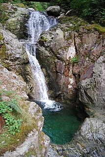
Golden Ears Provincial Park is a Provincial park in British Columbia, Canada and is 555.9 square kilometres (214.6 sq mi). It is named after the prominent twin peaks which are commonly referred to as Golden Ears. The park's southern end is located on the northern edge of the district municipality of Maple Ridge on the north side of the Fraser River.

Sasquatch Provincial Park is a provincial park in Kent, British Columbia, Canada.
Davis Lake Provincial Park is a 185 acres (0.75 km2) park in British Columbia, Canada, established as a protected provincial park in October 1963. It is located east of the southern end of Stave Lake, northeast of Mission, British Columbia, approximately 18 km north on Sylvester Rd from BC Highway 7. There are campgrounds and beaches at the south end of the lake, access is walk-in only via a 1 km unmaintained gravel road.

Gordon Bay Provincial Park is a provincial park in British Columbia, Canada.
Junction Sheep Range Provincial Park is a provincial park in British Columbia, Canada, located near the confluence of the Chilcotin and Fraser Rivers on the west bank of the latter river.
Jimsmith Lake Provincial Park is a provincial park in British Columbia, Canada. The small park has Jimsmith Lake surrounded by mixed forest. It is located just south of Cranbrook.

Kikomun Creek Provincial Park is a provincial park in British Columbia, Canada.

Kiskatinaw Provincial Park is a provincial park located in Peace River Regional District in British Columbia, Canada. It was established on May 1, 1962 to protect a prominent horseshoe-shaped incised meander in the Kiskatinaw River where a historic curved bridge crosses the river along the original alignment of the Alaska Highway.

Lockhart Beach Provincial Park is a provincial park Located 40 km north of Creston, British Columbia, Canada, on BC Highway 3A. "This park and the adjacent Lockhart Creek Provincial Park extend 3 hectares, from the sunny shores of Kootenay Lake to the headwaters of Lockhart Creek. "This small park provides the only easy access to public camping along the south arm of Kootenay Lake. An 18 site campground and day use area are located near a sand and fine gravel beach where visitors can relax and enjoy the clear waters of Kootenay Lake."

Maxhamish Lake Provincial Park and Protected Area is a 27,516-hectare (67,990-acre) provincial park in British Columbia, Canada.
Meziadin Lake Provincial Park is a provincial park in British Columbia, Canada. It sits 40 miles (64 km) east of Stewart, British Columbia; inland from the Bear Pass. A beautiful mountain lake, surrounded by forest, it is also defined to the west by a ridge a tall mountains of the Coast Range. There are campsites, a beach and ample fish in the lake.
Norbury Lake Provincial Park is a 97-hectare (240-acre) provincial park in British Columbia, Canada.
One Island Lake Provincial Park is a provincial park in British Columbia, Canada.
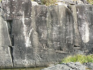
Sproat Lake Provincial Park is a provincial park near Port Alberni in British Columbia, Canada's Vancouver Island. Its name derives from a lake named after 19th century entrepreneur and colonial official Gilbert Malcolm Sproat.

Kettle River Recreation Area is a 179 hectare provincial recreation area located inside a sharp S-bend of the Kettle River approximately 6 kilometres north of the community of Rock Creek, British Columbia. It is one of only two recreation areas in British Columbia, the other being Coquihalla Summit Recreation Area.

