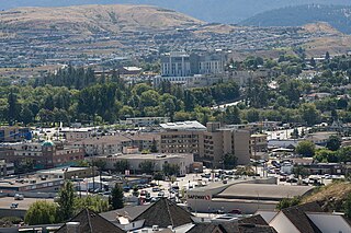
Vernon is a city in the Okanagan region of the Southern Interior of British Columbia, Canada. It is 440 km (270 mi) northeast of Vancouver. Named after Forbes George Vernon, a former MLA of British Columbia who helped establish the Coldstream Ranch in nearby Coldstream, the City of Vernon was incorporated on December 30, 1892. The City of Vernon has a population of 40,000 (2013), while its metropolitan region, Greater Vernon, has a population of 58,584 as of the Canada 2011 Census. With this population, Vernon is the largest city in the North Okanagan Regional District. A resident of Vernon is called a "Vernonite".

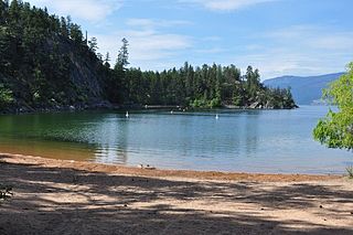
Kalamalka Lake is a large lake in the interior plateau of southern central British Columbia, Canada, east of Okanagan Lake. The lake is located approximately 4 kilometres (2.5 mi) south of the city of Vernon and is its main drinking water supply. The lake is named after the Okanagan First Nation chief who occupied its northern shores.

The Okanagan, also called the Okanagan Valley and sometimes the Okanagan Country, is a region in the Canadian province of British Columbia defined by the basin of Okanagan Lake and the Canadian portion of the Okanagan River. It is part of the Okanagan Country, extending into the United States as Okanogan County in north-central Washington. According to the 2016 Canadian census, the region's population is 362,258. The largest populated cities are Kelowna, Penticton, Vernon, and West Kelowna.

Okanagan Mountain Provincial Park is a provincial park within the Okanagan-Similkameen Regional District of British Columbia, Canada, focused on the mountain of the same name and located on the east side of Okanagan Lake, opposite Peachland and immediately south of the City of Kelowna. The park is one of the largest in the area, covering 110.38 square kilometres (42.62 sq mi). Most of the park is only accessible by foot, horseback, bicycle, or boat as motor vehicle access is restricted to BC Parks staff and technicians servicing the three telecommunications towers in the park.

Adams Lake Provincial Park is a provincial park in British Columbia, Canada. It encompasses three distinct parks: Adams Lake Provincial Park, Adams Lake Marine Provincial Park, and Adams Lake Marine Provincial Park.
Ellison Provincial Park is a provincial park in British Columbia, Canada, located on the east side of Okanagan Lake to the south of the city of Vernon. The park contains approximately 219 acres (0.89 km2) of land, 200 ha. of it upland, 19 ha. of it foreshore.

sw̓iw̓s Provincial Park is a provincial park in British Columbia, Canada, located on the west side of Osoyoos Lake in the town of Osoyoos, which is on the Canada-United States border at the southern end of the Okanagan region of British Columbia. Approximately 38 hectares in size, the park was originally created in 1939. The name was changed from Haynes Point to sw̓iw̓s, the original Okanagan (Syilx'tsn) name for the region, meaning "narrowing of the waters".

Herald Provincial Park is a provincial park in British Columbia, Canada.
Kekuli Bay Provincial Park, formerly Kalamalka West Provincial Park, is a provincial park in British Columbia, Canada, located on the west shore of Kalamalka Lake on BC Highway 97 south of Vernon. The lake is popular for waterskiing and boating, and the park includes a boat launch, as well as a campground with a view of the lake. The park was established in 1990. Its size is about 57 hectares.
Monte Creek Provincial Park is a provincial park in British Columbia, Canada, located in the locality of Monte Creek, British Columbia. Created in 1996, it is only 3 hectares in size, and protects a forested riparian area and also quiggly hole ("kekuli") sites of the Shuswap people, which have been formally studied as an archaeological site. The location was also part of the route of the Hudson's Bay Brigade Trail to the Cariboo via Kamloops from what is now the United States, as was Monte Lake in the upper basin of the eponymous creek.
Monte Lake Provincial Park is a provincial park in British Columbia, Canada, located on the east side of Monte Lake and to the south of the community of Monte Lake, British Columbia which is at the north end of the lake. About five hectares in size, it protects an area of Ponderosa pine and grasslands.
Okanagan Falls Provincial Park, now officially named sx̌ʷəx̌ʷnitkʷ Provincial Park, is a provincial park in British Columbia, Canada, located within the traditional territory of the Osoyoos Indian Band. Since time immemorial, the Osoyoos Indian Band's Okanagan ancestors have inhabited and cared for the lands and waters in their traditional territory. The park is also located within the town of Okanagan Falls, protecting the area around the waterfall of the same name, which lies below the outlet of Skaha Lake in the course of the Okanagan River.

Pillar Provincial Park is a provincial park in British Columbia, Canada. It is located 11 km (6.8 mi) north of Highway 97 at Falkland. The park area is 2.34 hectares and protects a stone pillar on the hillside above Pillar Lake.
Coldstream is a district municipality in British Columbia, Canada, located at the northern end of Kalamalka Lake in the Okanagan Valley. Incorporated on December 21, 1906, Coldstream celebrated its centennial in 2006. The municipality is directly southeast of Vernon and is considered part of Greater Vernon. It is a member municipality of, and also the location of the head offices, of the Regional District of North Okanagan.
Cougar Canyon is a canyon near Kalamalka Lake Provincial Park, in the district municipality of Coldstream.
The Okanagan Highland is an elevated hilly plateau area in British Columbia, Canada, and the U.S. state of Washington. Rounded mountains with elevations up to 8,000 ft (2,400 m) above sea level and deep, narrow valleys are characteristic of the region.

Vaseux Lake is a shallow freshwater lake located along the course of the Okanagan River in the Okanagan Valley of British Columbia, Canada.

The Okanagan Country, also known as the Okanagan Valley, is a region located in the Canadian province of British Columbia and the U.S. state of Washington, defined by the basin of Okanagan Lake and the Okanagan River. With an estimated 400,000 residents, the Okanagan Country spans from the Thompson Plateau near Grindrod, British Columbia in the Okanagan to the Okanagan Highland near Douglas County, Washington in the Okanogan. The largest city in the Canadian portion is Kelowna, with a metropolitan population of 194,882 residents as of 2016, while the largest city in the American portion is Omak, with 4,881 residents as of 2011. The region took its current name in honor of the Okanagan term, ukʷnaqín. The mild climate and close proximity to lakes, rivers and mountainous regions make the Okanagan Country an outdoor recreational destination. The region's economy is dominated by the primary sector industries of agriculture and forestry, although economic diversification has also occurred with retirement communities and recreational tourism. The American portion is considered to be more remote than the Canadian division, with approximately 10 percent of the population.

Skaha Bluffs Provincial Park is a provincial park in British Columbia, Canada. Skaha Bluffs lies within the asserted territory of the Okanagan Nation Alliance. World-class climbing opportunities are found at Skaha Bluffs, recreational climbing has been occurring in the area since the 1980s.
Columbia Lake Ecological Reserve is a nature reserve on Columbia Lake in the East Kootenay region of British Columbia, Canada, located on the east side of Columbia Lake just north of the village of Canal Flats.

