Related Research Articles

The Kettle Valley Railway was a subsidiary of the Canadian Pacific Railway (CPR) that operated across southern British Columbia, west of Midway running to Rock Creek, then north to Myra Canyon, down to Penticton over to Princeton, Coalmont, Brookmere, Coquihalla and finally Hope where it connected to the main CPR line.

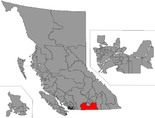
The Regional District of Kootenay Boundary (RDKB) is one of 28 regional districts in the province of British Columbia, Canada. As of the 2016 Canadian census, the population was 31,447. The area is 8,095.62 km2. The RDKB was incorporated in 1966 and consists of eight incorporated municipalities and five unincorporated electoral areas. The regional district's offices are in the City of Trail, with secondary offices in the City of Grand Forks. Other major population centres include the cities of Rossland and Greenwood, and the villages of Fruitvale, Warfield, and Montrose. The region also encompasses electoral areas A, B/Lower Columbia-Old Glory, C/Christina Lake, D/Rural Grand Forks and E/West Boundary including Rock Creek, Bridesville, Beaverdell and Big White Ski Resort.

The Kootenays or Kootenay is a region of southeastern British Columbia. It takes its name from the Kootenay River, which in turn was named for the Kutenai First Nations people.

British Columbia Southern Interior was a federal electoral district in the province of British Columbia, Canada, that had been represented in the House of Commons of Canada from 1997 to 2015.
Yale was a federal electoral district in British Columbia, Canada, that was represented in the House of Commons of Canada from 1872 to 1892 and from 1917 to 1953.
Yale–Cariboo was a federal electoral district in British Columbia, Canada, that was represented in the House of Commons of Canada from 1896 to 1917.

The Columbia Mountains are a group of mountain ranges along the Upper Columbia River in British Columbia, Montana, Idaho and Washington. The mountain range covers 135,952 km². The range is bounded by the Rocky Mountain Trench on the east, and the Kootenai River on the south; their western boundary is the edge of the Interior Plateau. Seventy-five percent of the range is located in Canada and the remaining twenty-five percent in the United States; American geographic classifications place the Columbia Mountains as part of the Rocky Mountains complex, but this designation does not apply in Canada. Mount Sir Sandford is the highest mountain in the range, reaching 3,519 metres (11,545 ft).
Grand Forks is a city in the Boundary Country of the West Kootenay region of British Columbia, Canada. It is located at the confluence of the Granby and Kettle Rivers, the latter being a tributary of the Columbia River. The city is just north of the Canada–United States border, approximately 500 km (310 mi) from Vancouver and 200 km (120 mi) from Kelowna and 23 km (14 mi) west of the resort area of Christina Lake by road.
Greenwood was the name of a provincial electoral district in the Canadian province of British Columbia. It was located in there Boundary Country west of Grand Forks around the city of Greenwood. It first appeared on the hustings in the large redistribution prior to the 1903 election. For the 1924 election it was merged with the Grand Forks riding to form Grand Forks-Greenwood.
Grand Forks was the name of a provincial electoral district in the Canadian province of British Columbia centred on the town of Grand Forks, in the Boundary Country between the Okanagan and Kootenay Countries. The riding first appeared as the result of a redistributing of the former West Kootenay which also created Greenwood, Rossland City, Nelson City, and Ymir in 1903. In 1924, the area of the Grand Forks riding was merged with that of the Greenwood riding to create Grand Forks-Greenwood. The area is currently represented by West Kootenay-Boundary.
Grand Forks-Greenwood was the name of a provincial electoral district in the Canadian province of British Columbia centred on the town of Grand Forks, in the Boundary Country between the Okanagan and Kootenay Countries. The riding first appeared in the 1924 election as the result of a merger of the former ridings of Greenwood and Grand Forks, and lasted until the 1963 election. As of 1966 the area was represented by Boundary-Similkameen. The same area is now part of West Kootenay-Boundary.
Boundary-Similkameen is a provincial electoral district in British Columbia. It was formed in 2008 out of parts of Penticton-Okanagan Valley, West Kootenay-Boundary and Yale-Lillooet. The riding's name corresponds to that of a former riding in the same area, with similar but not identical boundaries.
Okanagan-Boundary was a provincial electoral district in the Canadian province of British Columbia spanning the area from the Similkameen towns of Kaleden and Keremeos to Grand Forks and Christina Lake, and including the southern Okanagan towns of Okanagan Falls, Oliver, Osoyoos, Rock Creek and Greenwood. The riding first appeared in the 1991 election as the result of a redistribution of the former riding of Boundary-Similkameen. The same area is now part of West Kootenay-Boundary.

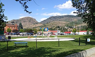
Midway is in the West Kootenay region of south central British Columbia. The village lies 13 kilometres (8 mi) west of Greenwood and 51 kilometres (32 mi) east of Osoyoos along Highway 3.

The Dewdney Trail is a 720 km (450 mi) trail in British Columbia, Canada, that served as a major thoroughfare in mid-19th century British Columbia. The trail was a critical factor in the development and strengthening of the newly established British colony of British Columbia, tying together mining camps and small towns that were springing up during the gold rush era prior to the colony's joining Canada in 1871. Establishing this route became important and urgent for the colony when many new gold finds occurred at locations near the US border that at the time were much more easily accessed from Washington Territory than from the then barely settled parts of the Lower Mainland and Cariboo. Approximately 80 percent of the trail's route has been incorporated into the Crowsnest Highway.

The British Columbia Interior, popularly referred to as the BC Interior or simply the Interior, is a geographic region of the Canadian province of British Columbia. While the exact boundaries are variously defined, the British Columbia Interior is generally defined to include the 14 regional districts that do not have coastline along the Pacific Ocean or Salish Sea, and are not part of the Lower Mainland. Other boundaries may exclude parts of or even entire regional districts, or expand the definition to include the regional districts of Fraser Valley, Squamish–Lillooet, and Kitimat–Stikine.
Robert Allan Brown was a well-known and flamboyant prospector and speculator in the 19th and early 20th centuries, in the Canadian province of British Columbia. He was known generally as Volcanic Brown, especially in the province's Kootenay and Boundary districts, as well as adjoining Eastern Washington. He was known as Sunset Brown in the Similkameen District, and to others as Crazy Brown. His enthusiastic nature and flamboyant personality made him a fixture in mining industry news over a wide region, spanning the British Columbia-United States border.
The Columbia and Western Railway (C&W) was a historic, and initially narrow gauge, railway in southern British Columbia.
Westbridge is in the Boundary Country region of south central British Columbia. The place straddles the West Kettle River immediately north of the confluence with the Kettle River. On BC Highway 33, the locality is by road about 87 kilometres (54 mi) northwest of Grand Forks, 64 kilometres (40 mi) northeast of Osoyoos, and 121 kilometres (75 mi) south of Kelowna.
References
- ↑ "Boundary Country" website, British Columbia government
- ↑ "Boundary Country" page, britishcolumbia.com Archived January 14, 2010, at the Wayback Machine
- ↑ Map of mining claims in the western Boundary Country and South Okanagan Archived September 16, 2004, at the Wayback Machine
- ↑ Sinixt Nation website