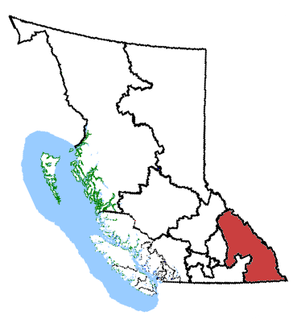
Kootenay—Columbia is a federal electoral district in British Columbia, Canada, that has been represented in the House of Commons of Canada since 1997.

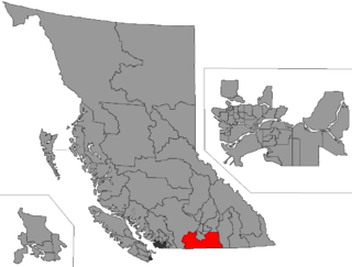
British Columbia Southern Interior was a federal electoral district in the province of British Columbia, Canada, that had been represented in the House of Commons of Canada from 1997 to 2015.
Yale was a federal electoral district in British Columbia, Canada, that was represented in the House of Commons of Canada from 1872 to 1892 and from 1917 to 1953.
Yale–Cariboo was a federal electoral district in British Columbia, Canada, that was represented in the House of Commons of Canada from 1896 to 1917.
Okanagan Boundary was a federal electoral district in British Columbia, Canada, that was represented in the House of Commons of Canada from 1953 to 1979.
Okanagan—Similkameen was a federal electoral district in British Columbia, Canada, that was represented in the House of Commons of Canada from 1979 to 1988.
West Kootenay-Boundary was a provincial electoral district for the Legislative Assembly of British Columbia, Canada from 2001 to 2009.
Yale-Lillooet was a provincial electoral district for the Legislative Assembly of British Columbia, Canada.
Greenwood was the name of a provincial electoral district in the Canadian province of British Columbia. It was located in there Boundary Country west of Grand Forks around the city of Greenwood. It first appeared on the hustings in the large redistribution prior to the 1903 election. For the 1924 election it was merged with the Grand Forks riding to form Grand Forks-Greenwood.
Grand Forks was the name of a provincial electoral district in the Canadian province of British Columbia centred on the town of Grand Forks, in the Boundary Country between the Okanagan and Kootenay Countries. The riding first appeared as the result of a redistributing of the former West Kootenay which also created Greenwood, Rossland City, Nelson City, and Ymir in 1903. In 1924, the area of the Grand Forks riding was merged with that of the Greenwood riding to create Grand Forks-Greenwood. The area is currently represented by West Kootenay-Boundary.
Grand Forks-Greenwood was the name of a provincial electoral district in the Canadian province of British Columbia centred on the town of Grand Forks, in the Boundary Country between the Okanagan and Kootenay Countries. The riding first appeared in the 1924 election as the result of a merger of the former ridings of Greenwood and Grand Forks, and lasted until the 1963 election. As of 1966 the area was represented by Boundary-Similkameen. The same area is now part of West Kootenay-Boundary.
Boundary-Similkameen is a provincial riding formed in 2008. It includes the populations of Penticton-Okanagan Valley, West Kootenay-Boundary and Yale-Lillooet. The riding's name corresponds to that of a former riding in the same area, with similar but not identical boundaries.
Rossland-Trail was the name of a provincial electoral district in the Canadian province of British Columbia centred on the towns of Rossland and Trail, in the West Kootenay. The riding first appeared in the 1924 election as the result of a redistribution of the former ridings of Greenwood and Trail, and lasted until redistribution in 1996. The same area is now part of West Kootenay-Boundary.
Trail was the name of a provincial electoral district in the Canadian province of British Columbia located in the West Kootenay region. It is named after the town of Trail, B.C.. It made its first appearance on the hustings in the election of 1916. Its predecessor riding was Rossland City (1903–1912) and from 1924 it was succeeded by the riding of Rossland-Trail.

The Regional District of Okanagan-Similkameen (RDOS) is in southern British Columbia, adjacent to the U.S. state of Washington. It is bounded by Fraser Valley Regional District to the west, Thompson-Nicola Regional District and Regional District of Central Okanagan to the north, Regional District of Kootenay Boundary to the east, and by Okanogan County, Washington to the south. At the 2011 census the population was 80,742. The district covers a land area of 10,413.44 square kilometres (4,020.65 sq mi). The administrative offices are in the City of Penticton.
The Boundary Country is a historical designation for a district in southern British Columbia lying, as its name suggests, along the boundary between Canada and the United States. It lies to the east of the southern Okanagan Valley and to the west of the West Kootenay. It is often included in descriptions of both of those regions but historically has been considered a separate region. Originally inclusive of the South Okanagan towns of Osoyoos and Oliver, today the term continues in use to refer to the valleys of the Kettle, West Kettle, and Granby Rivers and of Boundary and Rock Creeks and that of Christina Lake and of their various tributaries, all draining the south slope of the Monashee Mountains The term Boundary District as well as the term Boundary Country can both refer to the local mining division of the British Columbia Ministry of Mines, Energy and Petroleum Resources.
The Similkameen Country, also referred to as the Similkameen Valley or Similkameen District, but generally referred to simply as The Similkameen or more archaically, Similkameen, is a region roughly coinciding with the basin of the river of the same name in the Southern Interior of British Columbia. The term "Similkameen District" also refers to the Similkameen Mining District, a defunct government administrative district, which geographically encompasses the same area, and in more casual terms may also refer to the Similkameen electoral district, which was combined with the Grand Forks-Greenwood riding by the time of the 1966 election. The Similkameen Country has deep historical connections to the Boundary Country and the two are sometimes considered one region, partly as a result of the name of the electoral district. It is also sometimes classed as being part of the Okanagan region, which results from shared regional district and other administrative boundaries and names. The term "Similkameen District" may also historically refer to the Similkameen Division Yale Land District, which also includes Osoyoos and the Boundary Country to Osoyoos' east.
An electoral redistribution was undertaken in 2008 in British Columbia in a process that began in late 2005 and was completed with the passage of the Electoral Districts Act, 2008 on April 10, 2008. The redistribution modified most electoral boundaries in the province and increased the number of MLAs from 79 to 85. The electoral boundaries created by the redistribution were first used in the 2009 provincial election.