
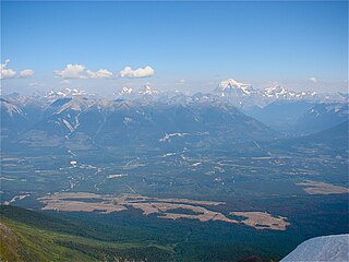
Mount Robson is the most prominent mountain in North America's Rocky Mountain range; it is also the highest point in the Canadian Rockies. The mountain is located entirely within Mount Robson Provincial Park of British Columbia, and is part of the Rainbow Range. Mount Robson is the second highest peak entirely in British Columbia, behind Mount Waddington in the Coast Range. The south face of Mount Robson is clearly visible from the Yellowhead Highway, and is commonly photographed along this route.

The Yellowhead Highway is a major interprovincial highway in Western Canada that runs from Winnipeg to Graham Island off the coast of British Columbia via Saskatoon and Edmonton. It stretches across the four western Canadian provinces of British Columbia, Alberta, Saskatchewan, and Manitoba and is part of the Trans-Canada Highway system and the larger National Highway System, but should not be confused with the more southerly, originally-designated Trans-Canada Highway. The highway was officially opened in 1970. Beginning in 1990, the green and white Trans-Canada logo is used to designate the roadway.

The Grand Trunk Pacific Railway was a historic Canadian transcontinental railway running from Fort William, Ontario to Prince Rupert, British Columbia, a Pacific coast port. East of Winnipeg the line continued as the National Transcontinental Railway (NTR), running across northern Ontario and Quebec, crossing the St. Lawrence River at Quebec City and ending at Moncton, New Brunswick. The Grand Trunk Railway (GTR) managed and operated the entire line.

The Yellowhead Pass is a mountain pass across the Continental Divide of the Americas in the Canadian Rockies. It is on the provincial boundary between the Canadian provinces of Alberta and British Columbia, and lies within Jasper National Park and Mount Robson Provincial Park.
Tkʼemlúps te Secwépemc, abbreviated TteS and previously known as the Kamloops Indian Band, is a First Nations government within the Shuswap Nation Tribal Council, which represents ten of the seventeen Secwepemc band governments, all in the southern Central Interior region, spanning the Thompson and Shuswap districts. It is one of the largest of the 17 groups into which the Secwepemc (Shuswap) nation was divided when the Colony of British Columbia established an Indian reserve system in the 1860s.

The Secwépemc, known in English as the Shuswap people, are a First Nations people residing in the interior of the Canadian province of British Columbia. They speak one of the Salishan languages, known as Secwepemc or Shuswap.

Valemount is a village municipality of 1,018 people in east central British Columbia, Canada, 320 kilometres (200 mi) from Kamloops, British Columbia. It is between the Rocky, Monashee, and Cariboo Mountains. It is the nearest community to the west of Jasper National Park, and is also the nearest community to Mount Robson Provincial Park, which features Mount Robson, the tallest mountain in the Canadian Rockies. Outdoor recreation is popular in summer and winter—hiking, skiing, snowmobiling, cross-country skiing, mountain biking and horseback riding are common activities. Valemount is one of 14 designated resort municipalities in British Columbia.

The Thompson Plateau forms the southern portion of the Interior Plateau of British Columbia, Canada, lying to the west of Okanagan Lake, south of the Thompson River and east of the Fraser River. At its most southern point the plateau is squeezed by the mountainous terrain of the Cascade Range abutting closer to the Okanagan Valley. Its southwestern edge abuts the Canadian Cascades portion of that extensive range, more or less following the line of the Similkameen River, its tributary the Tulameen River, and a series of passes from the area of Tulameen, British Columbia to the confluence of the Thompson River with the Nicoamen River, a few kilometres (miles) east of Lytton, British Columbia, which is in the Fraser Canyon. Its northeastern edge runs approximately from the city of Vernon, British Columbia through the valley of Monte Creek to the junction of the same name just east of the city of Kamloops. Northeast of that line is the Shuswap Highland.

The British Columbia Interior, popularly referred to as the BC Interior or simply the Interior, is a geographic region of the Canadian province of British Columbia. While the exact boundaries are variously defined, the British Columbia Interior is generally defined to include the 14 regional districts that do not have coastline along the Pacific Ocean or Salish Sea, and are not part of the Lower Mainland. Other boundaries may exclude parts of or even entire regional districts, or expand the definition to include the regional districts of Fraser Valley, Squamish–Lillooet, and Kitimat–Stikine.
The Williams Lake First Nation is a First Nations government of the Secwepemc (Shuswap) Nation, located in the Cariboo region of the Central Interior region of the Canadian province of British Columbia, at the city of Williams Lake. It was created when the government of the then-Colony of British Columbia established an Indian reserve system in the 1860s. It is a member government of the Northern Shuswap Tribal Council. Its main Indian Reserve is Williams Lake Indian Reserve No. 1, a.k.a. "Sugarcane" or "The Cane" or "SCB".

The Stswecem'c Xgat'tem First Nation, formerly known as Canoe Creek Band/Dog Creek Indian Band, created as a result of merger of the Canoe Creek Band and Dog Creek Band is a First Nations government of the Secwepemc (Shuswap) Nation, located in the Fraser Canyon-Cariboo region of the Central Interior of the Canadian province of British Columbia. It was created when the government of the then-Colony of British Columbia established an Indian reserve system in the 1860s. It is a member government of the Northern Shuswap Tribal Council.
Tête Jaune Cache is an unincorporated rural area and the site of an important abandoned historic town in British Columbia, Canada. Its population is approximately 500. It is on the Fraser River in the Robson Valley at the intersection of Yellowhead Highways 5 and 16. Tête Jaune Cache is located 18 km north of Valemount, B.C., 101 km west of Jasper, Alberta, 241 km east of Prince George, B.C., and 332 km north of Kamloops, B.C., by road.
Pierre Bostonais or Pierre Hastination, better known as Tête Jaune, was an Iroquois (Haudenosaunee)-Métis trapper, fur trader, and explorer who worked for the North West Company and Hudson's Bay Company during the 18th and 19th centuries. His nickname means 'yellow head' in French and was given to him because of his blond hair. The name Bostonais refers to his probable American origin: First Nations people applied that name to American traders.

Thompson Country, also referred to as The Thompson and sometimes as the Thompson Valley and historically known as the Couteau Country or Couteau District, is a historic geographic region of the Southern Interior of British Columbia, more or less defined by the basin of the Thompson River. This is a tributary of the Fraser; the major city in the area is Kamloops.
In the Canadian province of British Columbia, Big Bend Country is the region around the northernmost section of the Columbia River, which changes from a northwestward course along the Rocky Mountain Trench to curve around the northern end of the Selkirk Mountains to head southwest between that range and the Monashee Mountains, which lie to the west. The area is part of the larger Columbia Country, which includes the Columbia Valley and upper Arrow Lakes of eastern British Columbia. The 2,300 square miles (6,000 km2) north of the railway line, and enclosed by the river, roughly defines the Big Bend. However, in earlier eras, the descriptive was more narrowly understood.

The Adams River is a tributary to the Thompson and Fraser Rivers in British Columbia, Canada. Beginning in the Monashee Mountains to the north, the Upper Adams River flows mainly southward and eventually reaches Adams Lake. The Lower Adams River begins at the southern end of the lake and flows into the extreme western end of Shuswap Lake. The river is one of the most important sockeye salmon breeding areas in North America. The run occurs in mid-October and can bring millions of fish to a concentrated area near the river mouth. Excavations of Secwepemc villages on the river have shown a long tradition of habitation and salmon fishing in the area. The river also served as an important transportation route for early logging operations in the watershed.
The Simpcw First Nation, formerly known as the North Thompson Indian Band, is a First Nations band government based in the Thompson Country of British Columbia, Canada. It is a member of the Shuswap Nation Tribal Council. It is a First Nations government of the Secwepemc (Shuswap) Nation, located in the Central Interior region of the Canadian province of British Columbia. The band's main community is at Chu Chua, British Columbia. Four of the five First Nation Reserves in Simpcw territory were designated on July 5, 1877 and the fifth was designated on February 24, 1916. The Shuswap language name for North Thompson Band's community and reserve is 'Simpcw'.

Wells Gray Provincial Park is a large wilderness park located in east-central British Columbia, Canada. The park protects most of the southern, and highest, regions of the Cariboo Mountains and covers 5,415 square kilometres. It is British Columbia's fifth largest provincial park, after Tweedsmuir, Tatshenshini, Spatsizi and Northern Rocky Mountains.
The McLennan River is a tributary of the Fraser River in the Robson Valley region of British Columbia. The river was named after an engineer on one of the Canadian Pacific Railway surveys in the 1870s.
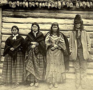
The Texqa'kallt or Xexka'llt are a division of the Shuswap people of British Columbia that are historically cited as living in and around the North Thompson, through to the Robson Valley. Historic accounts record them as being a mixed peoples speaking Cree and Shuswap, and ethnically of Iroquois, Cree and Shuswap origin. They are known for their participation in the Shuswap-Sekani War, a series of scattered skirmishes and conflicts in and around southern-central British Columbia during the 1780s.
