Mount Robson

Last updated
Mount Robson
Yexyexéscen (Shuswap)
Mount Robson panorama (cropped).jpg
Highest point
Elevation 3,954 m (12,972 ft) [1] [2] [3] [4]
Prominence 2,829 m (9,281 ft) [2]
Isolation 460 km (290 mi)  OOjs UI icon edit-ltr-progressive.svg
Listing
Coordinates 53°06′38″N119°09′23″W / 53.11056°N 119.15639°W / 53.11056; -119.15639 [5]
Naming
Nickname Cloud Cap Mountain
Native nameYexyexéscen (Shuswap)
English translationStriped Rock
Geography
Canada British Columbia relief location map.jpg
Red triangle with thick white border.svg
Mount Robson
Country Canada
Province British Columbia
District Cariboo Land District
Parent range Rainbow Range (Canadian Rockies)
Topo map NTS   83E3 Mount Robson [5]
Climbing
First ascent July 31, 1913 by William W. Foster, Albert H. McCarthy and Conrad Kain [2] [3]
Easiest route South face (UIAA IV)

Mount Robson is the most prominent mountain in North America's Rocky Mountain range; it is also the highest point in the Canadian Rockies. The mountain is located entirely within Mount Robson Provincial Park of British Columbia, and is part of the Rainbow Range. Mount Robson is the second highest peak entirely in British Columbia, behind Mount Waddington in the Coast Range. The south face of Mount Robson is clearly visible from the Yellowhead Highway (Highway 16), and is commonly photographed along this route.

Contents

Mount Robson was likely named after Colin Robertson, who worked for both the North West Company and the Hudson's Bay Company at various times in the early 19th century, though there was confusion over the name as many assumed it to have been named for John Robson, an early premier of British Columbia. The Texqa’kallt, a Secwepemc people and the earliest known inhabitants of the area, call it Yexyexéscen (striped rock), spelled in Dawson 1891 as Yuh-hai-has-kun, The Mountain of the Spiral Road. [6] [7] Other unofficial names include Cloud Cap Mountain. [3]

Colin Robertson Colin Robertson (fur trader).jpg
Colin Robertson

Geography and climate

Upper SE face seen from the Selwyn Range Mount Robson SE.JPG
Upper SE face seen from the Selwyn Range

Mount Robson boasts great vertical relief over the local terrain. From Kinney Lake, the south-west side of the mountain rises 2,975 m (9,760 ft) to the summit. The north face of Mount Robson is heavily glaciated and 800 m (2,600 ft) of ice extends from the summit to the Berg Glacier.

The north face can be seen from Berg Lake, and reached by a 19 km (12 mi) hike. The lake is approximately 2 km long and lies at 1,646 m (5,400 ft) elevation. There are backcountry campgrounds at each end of the lake and a log shelter on its banks, named Hargreaves Shelter in honor of the Hargreaves family who operated the Mount Robson Ranch across the Fraser River from the mountain and who outfitted most of the early trips into Berg Lake. The Berg Glacier calves directly into the lake. The Robson Glacier, which fills the cirque and valley between Mount Robson and Mount Resplendent, in the early 1900s fed directly into both Berg lake and Adolphus Lake, straddling the Continental Divide and draining thus to both the Arctic and Pacific oceans via the Smoky and Robson Rivers, respectively. It since has receded more than 2 kilometres and is the source of the Robson River only. The peak of Mount Robson has a tundra climate (ET). [8]

Climate data for Mount Robson Peak 1981-2010 (53.110 -119.156)
MonthJanFebMarAprMayJunJulAugSepOctNovDecYear
Mean daily maximum °C (°F)−9.3
(15.3)
−7.8
(18.0)
−6.3
(20.7)
−3.0
(26.6)
−0.5
(31.1)
3.3
(37.9)
6.7
(44.1)
7.1
(44.8)
7.3
(45.1)
0.7
(33.3)
−5.8
(21.6)
−7.9
(17.8)
−1.3
(29.7)
Daily mean °C (°F)−12.9
(8.8)
−12.2
(10.0)
−10.7
(12.7)
−7.6
(18.3)
−2.1
(28.2)
1.6
(34.9)
4.9
(40.8)
5.1
(41.2)
2.9
(37.2)
−4.4
(24.1)
−10.7
(12.7)
−12.5
(9.5)
−4.9
(23.2)
Mean daily minimum °C (°F)−16.5
(2.3)
−16.7
(1.9)
−15.1
(4.8)
−12.2
(10.0)
−3.6
(25.5)
−0.2
(31.6)
3.0
(37.4)
3.2
(37.8)
−1.4
(29.5)
−9.5
(14.9)
−15.6
(3.9)
−17.2
(1.0)
−8.5
(16.7)
Average precipitation mm (inches)271
(10.7)
257
(10.1)
238
(9.4)
153
(6.0)
134
(5.3)
157
(6.2)
157
(6.2)
173
(6.8)
234
(9.2)
307
(12.1)
357
(14.1)
175
(6.9)
2,613
(103)
Source: http://www.climatewna.com/ClimateBC_Map.aspx

History

Mount Robson in British Columbia. Mount Robson Twilight.jpg
Mount Robson in British Columbia.

In 1893, 5 years after the expedition of A.P. Coleman to Athabasca Pass and the final settling of the mistaken elevations of Mount Hooker and Mount Brown, Mount Robson was first surveyed by James McEvoy and determined to be the highest peak in the Canadian Rockies. [9] The first documented ascent of Mount Robson, led by the young guide Conrad Kain, at its time the hardest ice face to be climbed on the continent, was achieved during the 1913 annual expedition organized by a large party of Alpine Club of Canada members who made use of the newly completed Grand Trunk Pacific railway to access the area. Prior to 1913, it had been necessary to approach the mountain by pack train from Edmonton or Laggan via Jasper and Lucerne, so only a few intrepid explorers had made previous attempts at exploring the mountain. The most famous early ascensionist was George Kinney, a founding member of the Alpine Club, who on his twelfth attempt in August 1909 claimed to have reached the summit with local outfitter Donald "Curly" Phillips. A major controversy over this claim and over the implausible nature of his unlikely and dangerous route dominated the discourse within the Alpine Club elite, and he is now generally presumed to have reached the high summit ridge before being turned back at the final ice dome of the peak. [10] Kinney Lake, below the south face, is named in his honour.

Climbing

The North face (left) and Emperor face (right) in winter Mount Robson-North face.JPG
The North face (left) and Emperor face (right) in winter

The 1,500 m (4,900 ft) Emperor Face on the northwest side provides the most formidable challenge to elite climbers on the mountain, though the more popular routes are the Kain route and the southeast face. The Kain route follows the first ascent's path up the entire length of the Robson Glacier from its terminus above Robson Pass to the upper northeast face and the summit ridge. Mount Robson has a high failure rate on climbing to the top, with only about 10% of attempts being successful. Although the mountain is under 4,000 m (13,000 ft), there is no easy way to the summit and bad weather commonly rebuffs summit attempts. [2]

The main routes on Mount Robson include: [3]

See also

Berg Lake and Robson Berg Lake Melting in Late Spring.jpg
Berg Lake and Robson

Related Research Articles

<span class="mw-page-title-main">Mount Waddington</span> Mountain in British Columbia, Canada

Mount Waddington, once known as Mystery Mountain, is the highest peak in the Coast Mountains of British Columbia, Canada. Although it is lower than Mount Fairweather and Mount Quincy Adams, which straddle the United States border between Alaska and British Columbia, Mount Waddington is the highest peak that lies entirely within British Columbia. It and the subrange which surround it, known as the Waddington Range, stand at the heart of the Pacific Ranges, a remote and extremely rugged set of mountains and river valleys.

<span class="mw-page-title-main">Mount Assiniboine</span> Mountain in Alberta and British Columbia, Canada

Mount Assiniboine, also known as Assiniboine Mountain, is a pyramidal peak mountain on the Great Divide, on the British Columbia/Alberta border in Canada.

<span class="mw-page-title-main">Mount Columbia (Canada)</span> Highest mountain in Alberta, Canada

Mount Columbia is a mountain located in the Winston Churchill Range of the Rocky Mountains. It is the highest point in Alberta, Canada, and is second only to Mount Robson for height and topographical prominence in the Canadian Rockies. It is located on the border between Alberta and British Columbia on the northern edge of the Columbia Icefield. Its highest point, however, lies within Jasper National Park in Alberta.

<span class="mw-page-title-main">Berg Lake</span>

Berg Lake is a lake on the Robson River just below the river's source located within Mount Robson Provincial Park, at the doorstep of the north face of Mount Robson, the highest peak in the Canadian Rockies. It is partly fed by the Berg Glacier.

<span class="mw-page-title-main">Mount Robson Provincial Park</span> Provincial park in British Columbia, Canada

Mount Robson Provincial Park is a provincial park in the Canadian Rockies with an area of 2,249 km2. The park is located entirely within British Columbia, bordering Jasper National Park in Alberta. The B.C. legislature created the park in 1913, the same year as the first ascent of Mount Robson by a party led by Conrad Kain. It is the second oldest park in the provincial system. The park is named for Mount Robson, which has the highest point in the Canadian Rockies and is located entirely within the park.

<span class="mw-page-title-main">Conrad Kain</span> Austrian mountain guide

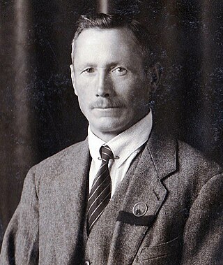
Conrad Kain was an Austrian mountain guide who guided extensively in Europe, Canada, and New Zealand, and was responsible for the first ascents of more than 60 routes in British Columbia. He is particularly known for pioneering climbs in the Purcell Mountains and the first ascents of Mount Robson (1913), Mount Louis (1916) and Bugaboo Spire (1916).

<span class="mw-page-title-main">Mount Forbes</span> Mountain in Banff NP, Canada

Mount Forbes is the seventh tallest mountain in the Canadian Rockies and the tallest within the boundaries of Banff National Park. It is located in southwestern Alberta, 18 km (11 mi) southwest of the Saskatchewan River Crossing in Banff. The mountain was named by James Hector in 1859 after Edward Forbes, Hector's natural history professor at the University of Edinburgh during the mid-19th century.

<span class="mw-page-title-main">Mount Edith Cavell</span> Mountain in Jasper National Park, Alberta, Canada

Mount Edith Cavell is a mountain in the Athabasca River and Astoria River valleys of Jasper National Park, and the most prominent peak entirely within Alberta.

<span class="mw-page-title-main">North Twin Peak</span> Mountain peak in Jasper NP, Alberta, Canada

North Twin (Peak) is one of the two main peaks that comprise The Twins massif located at the northeast corner of the Columbia Icefield in Jasper National Park, Alberta, Canada. The other lower peak is named South Twin (3,566 m). North Twin is the third-highest peak in the Canadian Rockies, after Mount Robson and Mount Columbia.

<span class="mw-page-title-main">Diadem Peak</span> Mountain peak in Jasper NP, Alberta, Canada

Diadem Peak is a peak located in the Sunwapta River Valley of Jasper National Park, Canada. Diadem Peak is essentially the high point of a ridge leading down from the slightly higher Mount Woolley. This peak was the first 11,000er north of the Columbia Icefield to be climbed and one of the few peaks in the Canadian Rockies to be climbed before 1900.

<span class="mw-page-title-main">Columbia Icefield</span> Ice field in the Canadian Rockies

The Columbia Icefield is the largest ice field in North America's Rocky Mountains. Located within the Canadian Rocky Mountains astride the Continental Divide along the border of British Columbia and Alberta, Canada, the ice field lies partly in the northwestern tip of Banff National Park and partly in the southern end of Jasper National Park. It is about 325 square kilometres (125 sq mi) in area, 100 to 365 metres in depth and receives up to 7 metres (280 in) of snowfall per year.

<span class="mw-page-title-main">The Bugaboos</span>

The Bugaboos are a mountain range in the Purcell Mountains of eastern British Columbia, Canada. The granite spires of the group are a popular mountaineering destination. The Bugaboos are protected within Bugaboo Provincial Park.

<span class="mw-page-title-main">Howse Peak</span> Mountain in Alberta and British Columbia, Canada

Howse Peak is the highest mountain in the Waputik Mountains, a subrange of the Canadian Rockies. It is located 5 km (3 mi) west of the Icefields Parkway, above Chephren Lake, on the continental divide between Alberta and British Columbia. At 3,295 m (10,810 ft), it is the 46th highest peak in Alberta, and the 59th highest in British Columbia.

<span class="mw-page-title-main">Abbot Pass hut</span> Historic building in Alberta, Canada

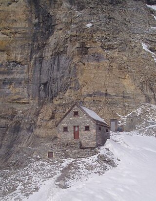
The Abbot Pass hut was an alpine hut located at an altitude of 2,925 metres (9,596 ft) in Abbot Pass in the Rocky Mountains in Alberta, Canada. It was nestled between Mount Victoria and Mount Lefroy, straddling the Great Divide, which, in this region, defines the boundary between Banff National Park in Alberta and Yoho National Park in British Columbia. While close to the border, the hut lay entirely in Banff National Park, and was the second-highest permanently habitable structure in Canada. The hut was maintained by the Alpine Club of Canada.

<span class="mw-page-title-main">Mount Goodsir</span> Mountain in British Columbia, Canada

Mount Goodsir is the highest mountain in the Ottertail Range, a subrange of the Park Ranges in British Columbia. It is located in Yoho National Park, near its border with Kootenay National Park. The mountain has two major summits, the South Tower and the North Tower, 3,525 metres (11,565 ft).

<span class="mw-page-title-main">Resplendent Mountain</span> Mountain in BC, Canada

Resplendent Mountain, or Mount Resplendent is a peak in the Canadian Rockies, located at the northern end of Mount Robson Provincial Park in British Columbia, Canada. It is a part of the Rainbow Range, and is a sister peak to the more famous Mount Robson, its nearest neighbour. Together they form a classic panorama seen by travellers on Via Rail trains and Highway 16. The mountain was named by Arthur P. Coleman, and Arthur O. Wheeler wrote, "On the east side it is clad from top to bottom in pure white snow, and presents with the sun shining upon it a spectacle of such wonderful brilliance that the aptness of the name became immediately apparent." The first ascent was achieved on the same historic 1911 trip in which Conrad Kain first scouted the climbing routes later to be used on the first ascent of Mount Robson.

<span class="mw-page-title-main">Donald "Curly" Phillips</span> Canadian guide and explorer

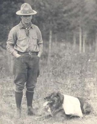
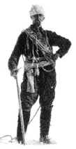
Donald Nelson "Curly" Phillips (1884-1938) was a Canadian guide, outfitter, entrepreneur, and explorer who was a part of many pioneering expeditions in the northern Canadian Rockies in the early twentieth century. He settled in Jasper, Alberta, and was involved in the development of mountain tourism in the region.

<span class="mw-page-title-main">Peter Kaufmann-Bohren</span> Swiss alpinist (b. 1886, d. 1971)

Peter Kaufmann-Bohren was a Swiss ski instructor and mountain guide, climbing in the Swiss Alps and the Canadian Rockies.

<span class="mw-page-title-main">Rearguard Mountain</span>

Rearguard Mountain is a 2,744-metre (9,003-foot) summit located within Mount Robson Provincial Park in British Columbia, Canada. It is part of the Rainbow Range which is a sub-range of the Canadian Rockies. Its nearest higher peak is Mount Robson, 4.0 km (2.5 mi) to the southwest. Rearguard is situated between Berg Lake and the Robson Glacier.

<span class="mw-page-title-main">Mount Anne-Alice</span> Mountain in British Columbia, Canada

Mount Anne-Alice is a mountain summit in the Canadian Rockies of British Columbia, Canada.

References

  1. "Topographic map of Mount Robson". opentopomap.org. Retrieved 2023-04-28.
  2. 1 2 3 4 "Mount Robson". Bivouac.com. Retrieved 2008-09-14.
  3. 1 2 3 4 "Mount Robson". cdnrockiesdatabases.ca. Retrieved 2003-10-26.
  4. "Mount Robson Provincial Park". BC Parks. Retrieved 2019-06-07.
  5. 1 2 "Mount Robson". Geographical Names Data Base . Natural Resources Canada . Retrieved 2023-04-28.
  6. "Mount Robson Provincial Park - Cultural Heritage". BC Parks. Archived from the original on 2022-11-28. Retrieved 2019-06-07.
  7. "Mount Robson Provincial Park, Draft Background Report" (PDF). BC Parks. September 2006. Archived from the original (PDF) on 2007-10-25. Retrieved 2007-06-05.
  8. "ClimateBC_Map". www.climatewna.com. Retrieved 2019-01-27.
  9. Fraser, Esther (2002). The Canadian Rockies: Early Travels and Explorations. Calgary: Fifth House. p. 193. ISBN   1-894004-85-X.
  10. Scott, Chic (2000). Pushing the Limits: The Story of Canadian Mountaineering . Calgary: Rocky Mountain Books. pp.  72–82. ISBN   0-921102-59-3.
Sources

Further reading