The Republic of Colombia is situated largely in the north-west of South America, with some territories falling within the boundaries of Central America. It is bordered to the north-west by Panama; to the east by Brazil and Venezuela; to the south by Ecuador and Peru; and it shares maritime limits with Costa Rica, Nicaragua, Honduras, Jamaica, the Dominican Republic, and Haiti.

Parícutin is a cinder cone volcano located in the Mexican state of Michoacán, near the city of Uruapan and about 322 kilometers (200 mi) west of Mexico City. The volcano surged suddenly from the cornfield of local farmer Dionisio Pulido in 1943, attracting both popular and scientific attention.

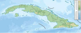
Villa Clara is one of the provinces of Cuba. It is located in the central region of the island bordering on the Atlantic Ocean to the north, Matanzas Province to the west, Sancti Spiritus Province to the east, and Cienfuegos Province to the South. Villa Clara shares with Cienfuegos and Sancti Spiritus on the south the Escambray Mountain Range. Its main cities are Santa Clara, Remedios, Sagua La Grande, Camajuani, Caibarién, Ranchuelo, Placetas, and Manicaragua.

Teide, or Mount Teide, is a volcano on Tenerife in the Canary Islands, Spain. Its summit is the highest point in Spain and the highest point above sea level in the islands of the Atlantic. If measured from the ocean floor, its height of 7,500 m (24,600 ft) makes Teide the third-highest volcano in the world, UNESCO and NASA rank it as Earth's third-tallest volcanic structure. Teide's elevation above sea level makes Tenerife the tenth highest island in the world.

Pico de Orizaba, also known as Citlaltépetl, is an active volcano, the highest mountain in Mexico and third highest in North America, after Denali of United States and Mount Logan of Canada. Pico de Orizaba is also the highest volcano in North America. It rises 5,636 metres (18,491 ft) above sea level in the eastern end of the Trans-Mexican Volcanic Belt, on the border between the states of Veracruz and Puebla. The volcano is currently dormant but not extinct, with the last eruption taking place during the 19th century. It is the second most prominent volcanic peak in the world after Mount Kilimanjaro. Pico de Orizaba is ranked 16th by topographic isolation.
The Escambray Mountains are a mountain range in the central region of Cuba, in the provinces of Sancti Spíritus, Cienfuegos and Villa Clara.

Pico Duarte is the highest peak in the Dominican Republic, on the island of Hispaniola and in all the Caribbean. At 3,101 m (10,174 ft) above sea level, it gives Hispaniola the 16th-highest maximum elevation of any island in the world. Additionally, it is only 85 kilometres northeast of the region's lowest point, Lake Enriquillo, 46 m below sea level. It is part of the Cordillera Central range, which extends from the plains between San Cristóbal and Baní to the northwestern peninsula of Haiti, where it is known as the Massif du Nord. The highest elevations of the Cordillera Central are found in the Pico Duarte and Valle Nuevo massifs.

Margarita Island is the largest island in the Venezuelan state of Nueva Esparta, situated off the north west coast of the country, in the Sea. The capital city of Nueva Esparta, La Asunción, is located on the island.

Cerro de Punta or Cerro Punta is the highest peak in Puerto Rico, rising to 1,338 meters (4,390 ft) above sea level. The mountain is part of the Cordillera Central and is located on the town boundary between the municipalities of Ponce and Jayuya in the central region of the main island of Puerto Rico.

The Escambray rebellion was an armed conflict from 1959 to 1965 in the Escambray Mountains during which several insurgent groups fought against the Cuban government led by Fidel Castro. The military operation against the rebellion was called the Struggle Against Bandits by the Cuban government.

The Ávila National Park, officially known as Waraira Repano National Park for its indigenous Cariban name, protects part of the Cordillera de la Costa Central mountain range, in the coastal region of central-northern Venezuela. The area's highest elevation is Pico Naiguatá, at 2,765 meters (9,072 ft) above sea level.

The Plaza Mayor in Trinidad, Cuba, is the historic centre of the town, declared a UNESCO World Heritage Site in 1988.
Topes de Collantes is a nature reserve park in the Escambray Mountains range in Cuba. It also refers to the third highest peak in the reserve, where a small settlement and tourist center is located, all sharing the same name.

Cumanayagua is a municipality and town in the Cienfuegos Province of Cuba. It is located in a valley near the Guamuhaya Mountains (usually these mountains are referred as Escambray Mountains, 23 kilometres east of Cienfuegos, the provincial capital.
Mount Malindig is a large potentially active stratovolcano on the island of Marinduque in the Philippines. It is the highest peak in the island having an elevation of 1,157 metres (3,796 ft) above sea level.

Pico Polaco is a mountain located in Argentina with a height of 5,950 metres (19,521 ft). It is located at Calingasta Department, San Juan Province, at the Cordillera de la Ramada.
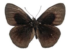
Calisto muripetens is a butterfly of the family Nymphalidae. It is endemic to Cuba, where it is only known from a few localities in the central Cuban mountains: the Guamuhaya massif, above 750 meters and up to 1,140 meters on Pico San Juan, the highest peak.