
Gannett Peak is the highest mountain peak in the U.S. state of Wyoming at 13,810 feet (4,210 m). It lies in the Wind River Range within the Bridger Wilderness of the Bridger-Teton National Forest. Straddling the Continental Divide along the boundary between Fremont and Sublette counties, it has the second greatest topographic prominence in the state (7076') after Cloud Peak (7077'), and is the highest ground for 290.36 miles in any direction.

Mount Stuart is a mountain in the Cascade Range, in the U.S. state of Washington. It is the second highest non-volcanic peak in the state, after Bonanza Peak and seventh-highest overall. Mount Stuart is the highest peak in the Stuart Range, and it is located in the central part of the Washington Cascades, south of Stevens Pass and east of Snoqualmie Pass in the Alpine Lakes Wilderness.
Castle Peak is the ninth highest summit of the Rocky Mountains of North America and the U.S. state of Colorado. The prominent 14,272-foot (4350.20 m) fourteener is the highest summit of the Elk Mountains and the Maroon Bells-Snowmass Wilderness. The peak is located 11.6 miles (18.7 km) northeast by north of the Town of Crested Butte, Colorado, United States, on the drainage divide separating Gunnison National Forest and Gunnison County from White River National Forest and Pitkin County. The summit of Castle Peak is the highest point of both counties.

Fremont Peak is the third highest peak in the state of Wyoming, surpassed only by Gannett Peak and Grand Teton, and straddles the boundary between Fremont and Sublette counties in the Wind River Range. It is named for American explorer John C. Frémont who climbed the peak with Charles Preuss and Johnny Janisse from August 13 to August 15, 1842. Kit Carson had been with the climbing party on its first attempt at the peak, but had gone back for supplies the day Fremont and his men reached the summit. Carson is thought by some to have been the first to climb neighboring Jackson Peak. At that time, Fremont Peak was mistakenly thought to be the highest mountain in the Rocky Mountains, although there are actually over 100 higher peaks in the Rocky Mountain range.

Mount Cleveland is the highest mountain in Glacier National Park, located in Montana, United States. It is also the highest point in the Lewis Range, which spans part of the northern portion of the park and extends into Canada. It is located approximately 3 mi (4.8 km) southeast of the southern end of Waterton Lake, and approximately 5 mi (8.0 km) south of the US–Canada border. The east side of the future national park was purchased by the federal government from the Blackfoot Confederacy in 1895 during the second term of President Grover Cleveland. According to the United States Board on Geographic Names, the mountain is named for the former president.
Francs Peak, elevation 13,158 feet (4,011 m), is the highest point in the Absaroka Range which extends from north-central Wyoming into south-central Montana, in the United States. It is in the Washakie Wilderness of Shoshone National Forest, and the peak is also the highest point in Park County, Wyoming, which includes much of Yellowstone National Park. It was named after Otto Franc, a cattle baron and homesteader in the Big Horn Basin in the latter half of the 19th century.
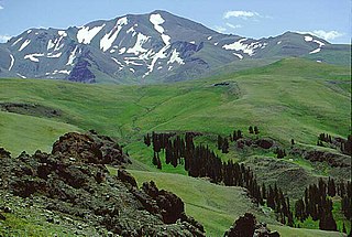
Crazy Peak, elevation 11,214 ft (3,418 m), is the highest peak in the Crazy Mountains, an island range of the Montana Rockies, in the United States. Crazy Peak dominates the surroundings, rising over 7,000 feet (2,100 m) above the Yellowstone River Valley, and is the highest peak in Montana north of the Beartooth Mountains, which are 50 miles (80 km) to the south. Crazy Peak is also the most topographically prominent peak in Montana. A small glacier exists on the northeast slope of the mountain. The mountain is located on private land within the Gallatin National Forest.

Mount Williamson, at an elevation of 14,379 feet (4,383 m), is the second-highest mountain in both the Sierra Nevada range and the state of California, and the sixth-highest peak in the contiguous United States.
Truchas Peak is the second highest peak in the U.S. State of New Mexico behind Wheeler Peak. It is in the Sangre de Cristo Mountains 26 miles (42 km) northeast of Santa Fe. It lies within the Pecos Wilderness, part of the Santa Fe National Forest. The name of the peak is Spanish for "trout" (plural). It is the highest point in both Rio Arriba and Mora counties. It is also the most southerly peak and land area in the continental United States to rise above 13,000 feet (3,962 m).

South Teton is the fifth-highest peak in the Teton Range, Grand Teton National Park, in the U.S. state of Wyoming. The peak is south of Middle Teton and just west of Cloudveil Dome and is part of the Cathedral Group of high Teton peaks. The 40-mile-long (64 km) Teton Range is the youngest mountain chain in the Rocky Mountains, and began their uplift 9 million years ago, during the Miocene. Several periods of glaciation have carved South Teton and the other peaks of the range into their current shapes.

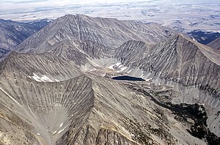
Mount Jefferson is the highest mountain in both the Toquima Range and Nye County in Nevada, United States. It is the sixth highest mountain in the state. As the high point of a range which is well separated from other ranges by low basins, Mount Jefferson has a high topographic prominence of 5,861 feet (1,786 m). This makes it the most prominent peak in Nye County and the third most prominent peak in Nevada. For similar reasons, it is also the highest mountain for over 90 miles in all directions. It is located about 50 miles (80 km) northeast of the county seat of Tonopah within the Alta Toquima Wilderness of the Humboldt-Toiyabe National Forest, near the smaller towns of Carvers and Round Mountain. Three distinct summits are located on a broad area of subalpine tundra: North Summit rises to 11,820 feet (3,603 m), Middle Summit to 11,692 feet (3,564 m), and South Summit to 11,949 feet (3,642 m). During the Pleistocene, alpine glaciers eroded several cirques east of the summit plateau.

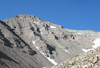
Bomber Mountain is the crest of a ridge line within the Bighorn Mountains of the U.S. State of Wyoming. It borders the south side of Cloud Peak, the tallest peak in the range. It is about 23 miles (37 km) west of Buffalo. A military aviation accident that occurred upon the mountain in 1943 led to it being named Bomber Mountain in 1946.

Clark Peak is the highest summit of the Medicine Bow Mountains range of the Rocky Mountains of North America. The prominent 12,960-foot (3,950 m) peak is located in the Rawah Wilderness of Routt National Forest, 6.3 miles (10.1 km) north-northwest of Cameron Pass, Colorado, United States, on the drainage divide between Jackson and Larimer counties. Clark Peak is the highest point of Jackson County and the entire drainage basin of the North Platte River.

McDonald Peak, elevation 9,820 feet (2,993 m), is located in the U.S. state of Montana and is the highest peak in the Mission Mountains. McDonald Peak is situated within the Flathead Indian Reservation. The peak has the second greatest topographic prominence of all summits within Montana and is almost 80 miles (130 km) away from the next highest mountain in the state. McDonald Glacier is on the north slope of the peak.

Diamond Peak is the highest point in the Lemhi Range in the Rocky Mountains in Idaho. At 12,202 feet (3,719 m) above sea level, it is the third highest peak in Idaho. It is situated 34.5 miles (55.5 km) east of Borah Peak in the Lost River Range, opposite the Little Lost River valley. It is the highest point in the Caribou–Targhee National Forest. The closest higher peak is Mount Church, which is 31.8 mi (51.2 km) to the west.
Downs Mountain is located in the Wind River Range in the U.S. state of Wyoming. Downs Mountain is the 15th highest peak in Wyoming. The summit is on the Continental Divide in both Shoshone and Bridger-Teton National Forests. The East Torrey Glacier is on the northern slopes of Downs Mountain, while Continental Glacier lies to the west and north and the Downs Glacier is 1 mi (1.6 km) to the south.

Twin Peaks is located in the Wind River Range in the U.S. state of Wyoming. Twin Peaks is the 20th highest peak in Wyoming. Twin Peaks is in the Bridger Wilderness of Bridger–Teton National Forest and is 0.58 mi (0.93 km) southwest of Mount Woodrow Wilson and about the same distance southeast of Split Mountain. Mammoth Glacier flows from the north slopes of the peak while the smaller Twins Glacier flows to the southeast.

Bighorn Peak is located in the Bighorn Mountains in the U.S. state of Wyoming. The peak is the seventh highest in the range and it is in the Cloud Peak Wilderness of Bighorn National Forest. Bighorn Peak is 1.5 miles (2.4 km) south of Darton Peak.
Mather Peaks is located in the Bighorn Mountains in the U.S. state of Wyoming. The peak is the sixth highest in the range and it is in the Cloud Peak Wilderness of Bighorn National Forest. Mather Peaks is 4.5 miles (7.2 km) northwest of Darton Peak and 3.2 mi (5.1 km) south of Bomber Mountain.

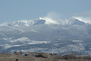
Carter Mountain is in Shoshone National Forest in the U.S. state of Wyoming. Carter Mountain slopes gently up from the Bighorn Basin to the east but has steep cliffs on its western face. The region is well known for large herds of bighorn sheep, pronghorn and elk.

