White Mountain (Wyoming)

Last updated
White Mountain
WhiteMountainWY.jpg
White Mountain's highest point (minus Pilot Butte) located near Rock Springs, Wyoming
Highest point
Elevation 7,623 ft (2,323 m)
Coordinates 41°34′41″N109°19′12″W / 41.57806°N 109.32000°W / 41.57806; -109.32000
Geography
Location Sweetwater County, Wyoming, U.S.
Climbing
Easiest route Roads from Rock Springs and Green River
The central portion of the mountain, from Rock Springs, Wyoming WhiteMountainWY2.jpg
The central portion of the mountain, from Rock Springs, Wyoming

White Mountain is a long mountain located in central Sweetwater County, Wyoming, near the cities of Rock Springs and Green River. The mountain is part of the Green River Formation, and contains communications towers that serve a number of purposes. Hundreds of carved figures also dot the sandstone cliffs at the White Mountain Petroglyph site and range from 200 to 1000 years old. Pilot Butte, located on top of White Mountain, is accessible from roads on the mountain.

Contents

Geology

Like its neighbor, Wilkins Peak, White Mountain is a member of the Green River Formation,Technically a plateau & aformation of the intermontane Lake Gosiute environment during the Eocene epoch. White Mountain is part of the Rock Springs Uplift, [1] and some of the largest oil shale and trona beds in the region are located west of the mountain. White Mountain contains sediment from a subcategory of the Green River Formation, known as the Wilkins Peak Formation . [2] [3]

The peak itself is 7,623 feet (2,323 m) in elevation and is located 5.4 miles (9 km) from Rock Springs, Wyoming and 8.85 miles (14 km) from Green River, Wyoming.

Communication uses

White Mountain houses communication radio towers for a number of local and regional uses. A tower for the radio station K299AG broadcasts a religious radio format on 107.7 FM. Programming on the station comes from KCSP-FM. [4] The local cable company, Sweetwater Television, owns the tallest tower, on the center of the mountain. This tower can be seen in the picture above. K28JU-D, the local PBS affiliate of KCWC-DT broadcasts from space on the tower as well, and as of August 2009, is the only television station broadcasting from White Mountain. [5] Located next to that tower are transmitters used by the local BLM office, as well as a tower for cellular telephones, owned by Union Wireless. [6]

On the side of the mountain facing Green River, two more radio towers are present. One of the towers is used for airport communications from a nearby airport. The other, owned by Verizon Wireless is used for cellular telephone transmissions. [7]

White Mountain, as seen from Wilkins Peak. Pilot Butte is to the left WhitemountainWY.jpg
White Mountain, as seen from Wilkins Peak. Pilot Butte is to the left

Pilot Butte

Ancestral Shoshone petroglyphs (White Mountain Petroglyphs), carved into the soft sandstone Ancestral Shoshone Indian petroglyphs (~1000 to ~200 years old) (White Mountain Petroglyphs, southwestern Wyoming, USA) 5 (22865206805).jpg
Ancestral Shoshone petroglyphs (White Mountain Petroglyphs), carved into the soft sandstone

Pilot Butte is located directly on top of White Mountain, and was named by early travelers in the region as a signal that they were close to the Green River. [8] Pilot Butte is also a part of the Wild Horse tour, and several herds of wild horses have been spotted in the area. [9] The butte is the second highest point in the immediate region, the first being Aspen Mountain to the south. It is 7,949 feet (2,423 m) in elevation at its highest point. The butte can be hiked, and used to contain a steel ladder to assist in reaching the summit. [10]

Petroglyphs

Hundreds of carved figures dot the sandstone cliffs at the White Mountain Petroglyph site in Wyoming’s Red Desert. Etched into the stone surface some 200 to 1,000 years ago, several figures appear to portray bison and elk hunts while others depict geometric forms or tiny footprints. Handprints are worn into the rock as well, providing visitors with a compelling connection to those who used the site long ago. [11]

Related Research Articles

<span class="mw-page-title-main">Sweetwater County, Wyoming</span> County in Wyoming, United States

Sweetwater County is a county in southwestern Wyoming, United States. As of the 2020 United States Census, the population was 42,272, making it the fourth-most populous county in Wyoming. Its county seat is Green River. By area, it is the largest county in Wyoming. Its southern boundary line abuts the north lines of the states of Colorado and Utah.

<span class="mw-page-title-main">Rock Springs, Wyoming</span> City in Wyoming, United States

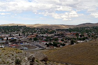
Rock Springs is a city in Sweetwater County, Wyoming, United States. The population was 23,036 at the 2010 census, making it the fifth most populated city in the state of Wyoming, and the most populous city in Sweetwater County. Rock Springs is the principal city of the Rock Springs micropolitan statistical area, which has a population of 37,975. Rock Springs is known as the Home of 56 Nationalities because of the influx of immigrants from all over the world who came to work in the coal mines that supplied the fuel to power the steam engines of the Union Pacific Railroad. The city's rich cultural heritage is celebrated each summer on International Day, a festival where the foods, costumes, and traditions of residents' ancestors are recreated and enjoyed at Bunning Park in downtown Rock Springs.

<span class="mw-page-title-main">Sweetwater River (Wyoming)</span> River in Wyoming, United States

The Sweetwater River is a 238-mile (383 km) long tributary of the North Platte River, in the U.S. state of Wyoming. As a part of the Mississippi River system, its waters eventually reach the Gulf of Mexico.

<span class="mw-page-title-main">Red Desert (Wyoming)</span> Arid region of south-central Wyoming, United States

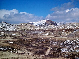
The Red Desert is a high-altitude desert and sagebrush steppe located in the south-central portion of the U.S. state of Wyoming, comprising approximately 9,320 square miles. Among the natural features in the Red Desert region are the Great Divide Basin, a unique endorheic drainage basin formed by a division in the Continental Divide, and the Killpecker Sand Dunes, the largest living dune system in the United States. In the 19th century, the Oregon, California, and Mormon Trails crossed the Continental Divide at South Pass, just north of the Red Desert. Today, busy Interstate 80 bisects the desert's southern region while gas field roads cross the desert.

KSIT is an American radio station licensed to serve the community of Rock Springs, Wyoming. KSIT's sister stations are KQSW 96.5, KRKK AM 1360, and KMRZ-FM.

<span class="mw-page-title-main">KZWB</span> Radio station in Green River, Wyoming

KZWB is a radio station broadcasting from Green River, Wyoming. The station signed on June 1, 2005. KZWB is owned by Wagonwheel Communications Corporation, who also owns KUGR and KZWB's two sister stations KYCS and KFRZ.

<span class="mw-page-title-main">KYCS</span> Radio station in Rock Springs, Wyoming

KYCS is a hot adult contemporary station broadcasting from Rock Springs, Wyoming.

<span class="mw-page-title-main">KFRZ</span> Radio station in Green River, Wyoming

KFRZ is a radio station broadcasting from Green River, Wyoming, serving southwestern Wyoming. Broadcasting a country music format, the station is part of The Radio Network, which includes sister stations KUGR, KYCS, and KZWB. KFRZ broadcasts satellite fed music from Westwood One formerly the Jones Radio Network. Like its sister stations, KFRZ has local news throughout the day, and sports highlights as well. The station is currently owned by Wagonwheel Communications Corp.

<span class="mw-page-title-main">KQSW</span> Radio station in Rock Springs, Wyoming

KQSW is a country music formatted radio station broadcasting from Rock Springs, Wyoming, serving southwestern Wyoming. The station is owned by Big Thicket Broadcasting of Wyoming, who identifies themselves as WyoRadio, which includes local sister stations KSIT, KMRZ-FM, and KRKK.

<span class="mw-page-title-main">Wilkins Peak</span> Mountain in United States of America

Wilkins Peak is a small mountain located in Sweetwater County, Wyoming, between the cities of Green River and Rock Springs. It is primarily used for radio and television station transmitters, but it also serves radio needs of the FAA, EMS, and local businesses such as Questar Gas. In 2003, a tower on the peak was knocked down by a vehicle delivering propane to customers. The tower was owned by Wyoming Public Radio and was serving the local area with programming from National Public Radio. There are numerous access roads to the peak and it is not gated and open year-round, weather permitting. Along with the radio uses, the mountain is also a popular location for mountain biking and hiking. The mountain contains geology typical of its location in southwestern Wyoming.

<span class="mw-page-title-main">Mansface Hill</span>

Mansface Hill is a mountain located in Green River, Wyoming. The mountain is named for its rock outcroppings, which form the shape of a face looking up into the sky.

Aspen Mountain is a long mountain located approximately 12 miles (19 km) south of Rock Springs, Wyoming and 5.5 miles (8.9 km) south of Arrowhead Springs, in Sweetwater County. The mountain gets its name from patches of Quaking Aspen trees located on the north and southern faces of the mountain. Various older topographical maps name the mountain "Quaking Aspen Mountain". Its primary use is for radio communications and it houses towers for various local and state companies.

Western Wyoming Community College (Western) is a public community college in Rock Springs, Wyoming. Western offers certificates, associate degrees, and a bachelor's degree. The college students are known as the Mustangs.

<span class="mw-page-title-main">Index of Wyoming-related articles</span>

The following is an alphabetical list of articles related to the U.S. state of Wyoming.

KZUW is a classical music radio station licensed to Reliance, Wyoming. The station is owned and operated by the University of Wyoming.

Sweetwater County School District #1 is a public school district based in Rock Springs, Wyoming, United States.

<span class="mw-page-title-main">Humpy Peak</span>

Humpy Peak is a peak located in the Uinta Mountain Range in northern Utah. It is approximately 27.56 miles (44 km) south of Evanston, Wyoming and 21.29 miles (34 km) east of Coalville, Utah. The summit has an elevation of 10,875 feet (3,315 m).

The Rock Springs Uplift is an area of uplifted Cretaceous to Eocene rocks in Wyoming surrounded and once covered by sediments of the Green River Formation which were deposited in the Eocene Lake Gosiute. The Rock Springs Uplift formed in the Late Cretaceous through the Eocene and is related to the Laramide orogeny. The structure is a north–south trending anticline with a surface expression of approximately 56 miles (90 km) by 28 mi (45 km). The community of Rock Springs is located on the western margin of the uplift.

<span class="mw-page-title-main">KREO (FM)</span> Radio station in James Town, Wyoming

KREO is an American radio station licensed to serve the community of James Town, Wyoming.

<span class="mw-page-title-main">Schiestler Peak</span>

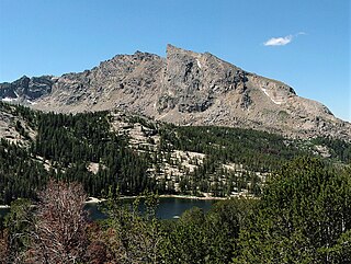
Schiestler Peak is an 11,624-foot-elevation (3,543-meter) mountain summit located in Sublette County of Wyoming, United States.

References

  1. "Green River". www.geology.wisc.edu.
  2. Eugster, H.P.; Hardie, L.A. (1975). "Sedimentation in an ancient playa-lake complex; the Wilkins Peak Member of the Green River Formation of Wyoming". Bulletin of the Geological Society of America. 86 (3): 319–334. doi:10.1130/0016-7606(1975)86<319:SIAAPC>2.0.CO;2 . Retrieved 20 Apr 2008.
  3. "Green River Formation". University of California Museum of Paleontology. Retrieved 2008-04-19.
  4. "K299AG-FM 107.7 MHz – Rock Springs, WY". radio-locator.com.
  5. "TV Query Results: K28JU-D WY ROCK SPRINGS, ETC. USA". www.fcc.gov. Retrieved 26 July 2021.
  6. "White Mountain Rock Springs side". www.angelfire.com.
  7. "White Mountain Green River side". www.angelfire.com.
  8. Wyoming Places Wiki / Pilot Butte
  9. "Wyoming Wild Horses – Pilot Butte Scenic Loop Tour".
  10. "A Little Grace (Liliana's Blog): Hiking up Pilot Butte, Wyoming". August 8, 2007.
  11. "White Mountain Petroglyphs". February 18, 2021.