Rock Springs, Wyoming

Last updated

Rock Springs, Wyoming
RockSpringsWY.jpg
Panorama of downtown Rock Springs, looking southeast from grant Street
Flag of Rock Springs, Wyoming.svg
Sweetwater County Wyoming Incorporated and Unincorporated areas Rock Springs Highlighted 5667235.svg
Location of Rock Springs in Sweetwater County, Wyoming.
Usa edcp location map.svg
Red pog.svg
Rock Springs, Wyoming
Location in the United States
Coordinates: 41°35′27″N109°13′21″W / 41.59083°N 109.22250°W / 41.59083; -109.22250
Country United States
State Wyoming
County Sweetwater
Rock Springs1888
Government
  MayorMax Mickelson
   State House
   State Senate John Kolb (R)
Area
[1]
  Total19.75 sq mi (51.16 km2)
  Land19.75 sq mi (51.16 km2)
  Water0.00 sq mi (0.00 km2)
Elevation
[2]
6,388 ft (1,947 m)
Population
 (2020) [3]
  Total23,526
  Density1,146.81/sq mi (442.78/km2)
Time zone UTC−7 (Mountain (MST))
  Summer (DST) UTC−6 (MDT)
ZIP Codes
82901, 82902, 82942
Area code 307
FIPS code 56-67235 [4]
GNIS feature ID1593588 [2]
Website www.rswy.net

Rock Springs is a city in Sweetwater County, Wyoming, United States. The population was 23,526 at the 2020 census, making it the fifth most populous city in the state of Wyoming, and the most populous city in Sweetwater County. Rock Springs is the principal city of the Rock Springs micropolitan statistical area, which has a population of 37,975. Rock Springs is known as the Home of 56 Nationalities because of the influx of immigrants from all over the world who came to work in the coal mines that supplied the fuel to power the steam engines of the Union Pacific Railroad. The city's rich cultural heritage is celebrated each summer on International Day, a festival where the foods, costumes, and traditions of residents' ancestors are recreated and enjoyed at Bunning Park in downtown Rock Springs.

Contents

Rock Springs is the site of Western Wyoming Community College and Wyoming's Big Show, a yearly event with a carnival and concerts which is held at the Sweetwater County Events Complex. [5]

Rock Springs is located in an energy-rich region with many oil and natural gas wells.

History

Rock Springs derives its name from a rock spring which flowed in the Number 6 district in the northern part of town. An erroneous story had indicated that the spring was found by a lost Pony Express rider, but the spring station was known to Jim Bridger before 1860; the Overland Stage station was located nearby. The spring disappeared when the coal mine operations interrupted the underground flow. Later an 'S' was added to the name making it "Rock Springs".

Through the years, water supplies have been a problem to Rock Springs. In the early days, Ed Cleg hauled domestic water from the sulfur spring north of Rock Springs and charged $.25 a barrel. With the mining operations, the water flow was interrupted and water was hauled from Green River and Point of Rocks. Beginning in 1887, a water main was started from the Green River and completed in 1888 to bring a continuous supply of water to Rock Springs.

Rock Springs has a multi-ethnic heritage; locals called it the 57 Variety Town. [6] The first immigrants were brought in by the railroad and coal mining companies. The Welsh and British people were initially most populous. Later, Irish, Blacks and refugees from the Southern part of the United States also came. The Scandinavian people were represented with a heavy Mormon recruitment.

One of the worst incidents of anti-immigrant violence in American history, known as the Rock Springs Massacre, occurred on September 2, 1885, whereby White miners slaughtered their Chinese counterparts due to anti-Chinese sentiment. [7] There are still remains of the old coal mining towns outside of Rock Springs.

On June 10, 1892, Rock Springs National Bank opened on 515 S Main St, across from the Union Pacific depot. The original sandstone building was designed by Mayor H.H. Edgar who chose an Italianate style. In 1907, when John Hay Sr. assumed control of the business, the location moved to C Street. RSNB owned the original building until 1921 when it was sold to Anton Mengoni. Hay Sr. navigated the bank through the Great Depression and World War II, before retiring in 1947. John Hay Jr., his son, then took control of the bank, having to control wild growth during Wyoming's massive energy boom in the 1970s. Another of Hay Sr.'s sons was Archibald (Archie) Hay. Archibald was killed in France by a German plane in 1918. In his memory, Post 24 of the American Legion, chartered in 1919, was named Archie Hay Post.

Rock Springs was featured on 60 Minutes in 1977 due to corruption within the Police Department and City Government. [8] A grand jury was called into session. The Sheriff of Sweetwater County, James Stark, testified and no wrongdoing was ever found. A follow-up was filmed 20 years later for the show City Confidential . The episode was named "Rock Springs: Deadly Draw in the Wild West". [9]

Geography

According to the United States Census Bureau, the city has a total area of 19.34 square miles (50.09 km2), all land. [10]

Climate

Rock Springs has a semi-arid climate (Köppen BSk) with cold, snowy winters and warm summers. Precipitation is usually light but has two peaks in mid spring and in early fall. Summer and winter are both drier.

The average December temperatures are a maximum of 33.2 °F (0.7 °C) and a minimum of 12.4 °F (−10.9 °C). The average July temperatures are a maximum of 86.3 °F (30.2 °C) and a minimum of 52.5 °F (11.4 °C). There an average of 14.7 days annually with highs of 90 °F (32.2 °C) or higher. There are an average of 183.6 nights with lows of 32 °F (0 °C) or lower and 11.5 nights with lows of 0 °F (−17.8 °C) or lower. The record high temperature was 98 °F (36.7 °C) on July 13, 2002, and the record low temperature was −37 °F (−38.3 °C) on January 12, 1963. [11]

The average annual precipitation is 10.45 inches (265.4 mm). There is an average of 61.7 days with measurable precipitation. The wettest calendar year was 1965 with 14.54 in (369.3 mm) and the driest 2012 with 3.14 in (79.8 mm). The most precipitation in one month was 3.67 in (93.2 mm) in September 1965, July 1973, and May 1995. The most snowfall in one year was 79.7 in (2.02 m) in 1995. The most snowfall in one month was 23.7 in (0.60 m) in February 2001. [11]

Climate data for Rock Springs, Wyoming (Rock Springs Airport), 1991–2020 normals, extremes 1948–present
MonthJanFebMarAprMayJunJulAugSepOctNovDecYear
Record high °F (°C)55
(13)
60
(16)
72
(22)
79
(26)
90
(32)
96
(36)
98
(37)
96
(36)
91
(33)
83
(28)
66
(19)
58
(14)
98
(37)
Mean maximum °F (°C)43.6
(6.4)
47.1
(8.4)
61.1
(16.2)
71.2
(21.8)
79.8
(26.6)
87.9
(31.1)
92.5
(33.6)
90.5
(32.5)
84.4
(29.1)
73.9
(23.3)
58.6
(14.8)
45.9
(7.7)
93.1
(33.9)
Mean daily maximum °F (°C)34.6
(1.4)
37.9
(3.3)
48.6
(9.2)
56.8
(13.8)
67.3
(19.6)
78.6
(25.9)
86.3
(30.2)
84.4
(29.1)
75.0
(23.9)
61.3
(16.3)
44.7
(7.1)
33.2
(0.7)
59.1
(15.0)
Daily mean °F (°C)23.5
(−4.7)
26.5
(−3.1)
36.0
(2.2)
43.1
(6.2)
52.3
(11.3)
61.9
(16.6)
69.4
(20.8)
67.6
(19.8)
58.1
(14.5)
46.3
(7.9)
32.7
(0.4)
22.8
(−5.1)
45.0
(7.2)
Mean daily minimum °F (°C)12.4
(−10.9)
15.1
(−9.4)
23.4
(−4.8)
29.5
(−1.4)
37.4
(3.0)
45.2
(7.3)
52.5
(11.4)
50.7
(10.4)
41.2
(5.1)
31.4
(−0.3)
20.7
(−6.3)
12.4
(−10.9)
31.0
(−0.6)
Mean minimum °F (°C)−7.9
(−22.2)
−5.4
(−20.8)
7.3
(−13.7)
16.0
(−8.9)
25.5
(−3.6)
34.3
(1.3)
45.5
(7.5)
42.8
(6.0)
29.6
(−1.3)
15.9
(−8.9)
2.7
(−16.3)
−6.6
(−21.4)
−14.3
(−25.7)
Record low °F (°C)−37
(−38)
−29
(−34)
−12
(−24)
2
(−17)
14
(−10)
26
(−3)
35
(2)
33
(1)
5
(−15)
−10
(−23)
−13
(−25)
−29
(−34)
−37
(−38)
Average precipitation inches (mm)0.45
(11)
0.43
(11)
0.61
(15)
1.07
(27)
1.88
(48)
0.82
(21)
0.92
(23)
0.89
(23)
1.17
(30)
1.03
(26)
0.66
(17)
0.52
(13)
10.45
(265)
Average snowfall inches (cm)6.1
(15)
5.8
(15)
4.4
(11)
1.9
(4.8)
0.5
(1.3)
0.0
(0.0)
0.0
(0.0)
0.0
(0.0)
0.0
(0.0)
2.3
(5.8)
3.8
(9.7)
6.5
(17)
31.3
(79.6)
Average precipitation days (≥ 0.01 in)4.44.74.25.68.84.84.14.85.55.04.05.861.7
Average snowy days (≥ 0.1 in)3.73.52.50.60.30.00.00.00.00.72.55.018.8
Source 1: NOAA [12]
Source 2: National Weather Service [11]

Demographics

Historical population
CensusPop.Note
1870 40
1880 7631,807.5%
1890 3,406346.4%
1900 4,36328.1%
1910 5,77832.4%
1920 6,45611.7%
1930 8,44030.7%
1940 9,82716.4%
1950 10,85710.5%
1960 10,371−4.5%
1970 11,65712.4%
1980 19,45866.9%
1990 19,050−2.1%
2000 18,708−1.8%
2010 23,03623.1%
2020 23,5262.1%
[13]

2010 census

At the 2010 census, [3] there were 23,036 people, 8,762 households and 5,849 families living in the city. The population density was 1,191.1 inhabitants per square mile (459.9/km2). There were 10,070 housing units at an average density of 520.7 per square mile (201.0/km2). The racial makeup of the city was 86.4% White, 1.4% African American, 0.8% Native American, 1.1% Asian, 0.1% Pacific Islander, 7.5% from other races, and 2.6% from two or more races. Hispanic or Latino of any race were 16.4% of the population.

There were 8,762 households, of which 35.8% had children under the age of 18 living with them, 49.9% were married couples living together, 9.8% had a female householder with no husband present, 7.1% had a male householder with no wife present, and 33.2% were non-families. 25.3% of all households were made up of individuals, and 6.6% had someone living alone who was 65 years of age or older. The average household size was 2.57 and the average family size was 3.07.

The median age in the city was 31.5 years. 26.4% of residents were under the age of 18; 11.4% were between the ages of 18 and 24; 29.4% were from 25 to 44; 24.6% were from 45 to 64; and 8.1% were 65 years of age or older. The gender makeup of the city was 52.1% male and 47.9% female.

2000 census

At the 2000 census, [4] there were 18,708 people, 7,348 households and 4,930 families living in the city. The population density was 1,014.4 per square mile (391.7/km2). There were 8,359 housing units at an average density of 453.3 per square mile (175.0/km2). The racial makeup of the city was 91.75% White, 1.07% African American, 0.86% Native American, 1.02% Asian, 0.03% Pacific Islander, 3.05% from other races, and 2.22% from two or more races. Hispanic or Latino of any race were 8.96% of the population.

There were 7,348 households, of which 35.4% had children under the age of 18 living with them, 52.5% were married couples living together, 10.2% had a female householder with no husband present, and 32.9% were non-families. 27.4% of all households were made up of individuals, and 8.5% had someone living alone who was 65 years of age or older. The average household size was 2.48 and the average family size was 3.02.

27.1% of the population were under the age of 18, 11.2% from 18 to 24, 29.2% from 25 to 44, 22.5% from 45 to 64, and 9.9% who were 65 years of age or older. The median age was 34 years. For every 100 females, there were 99.2 males. For every 100 females age 18 and over, there were 98.2 males.

The median household income was $42,584 and the median family income was $51,541. Males had a median income of $44,809 compared with $22,609 for females. The per capita income for the city was $19,396. About 6.4% of families and 9.4% of the population were below the poverty line, including 11.0% of those under age 18 and 8.7% of those age 65 or over.

Arts and culture

Wonder Bread store in Rock Springs, 2004 Wonder Bread Store, I-80, Rock Springs, Wyoming.jpg
Wonder Bread store in Rock Springs, 2004

Rock Springs hosts the International Festival, the Blues and Brews Festival, the Wyoming Chocolate Festival and the Rod and Rails Festival. [14] In July, August, and September, the city holds a county fair called Wyoming's Big Show.[ citation needed ]

Rock Springs has two public libraries, Rock Springs Library and White Mountain Library, both of which are branches of the Sweetwater County Library System. [15] The Rock Springs Library is also an original Carnegie Library, and has since been expanded to include an art gallery that is home to an original Norman Rockwell painting.

Education

Rock Springs Coal sign RSCoal.jpg
Rock Springs Coal sign
Western Wyoming Community College, December 2007 Westernwyomingcc.jpg
Western Wyoming Community College, December 2007

Public education in the city of Rock Springs is provided by Sweetwater County School District #1. Schools serving the city include: Desert View Elementary, Lincoln Elementary, Northpark Elementary, Overland Elementary, Pilot Butte Elementary, Sage Elementary, Stagecoach Elementary, Walnut Elementary, Westridge Elementary, Eastside Elementary, Rock Springs Junior High School, and Rock Springs High School. There are also two alternative campuses – Black Butte High School, and Roosevelt Learning Center.

Western Wyoming Community College is a community college in Rock Springs.

Media

Hyperlocal websites

Rock Springs is served by two hyperlocal news websites, SweetwaterNOW.com and Wyo4news.com

Print

Rock Springs is served by two print publications: Rock Springs Daily Rocket-Miner and the Green River Star (a weekly newspaper published in Green River).

Radio

Rock Springs is served by a number of radio stations including KRKK, KSIT, KQSW, KMRZ-FM, KYCS, KZWB, KFRZ and KUGR.

Television

All television stations in Rock Springs are translators or satellites of stations located elsewhere:

ChannelCallsignNetworkNotes
13 KGWR-TV CBS/ABC Satellite of KGWC-TV, Casper, Wyoming
28 K28JU-D PBS relay of Wyoming PBS

Infrastructure

Transportation

Highways

Airports

Rock Springs is served by Southwest Wyoming Regional Airport.

Railroads

Union Pacific serves Rock Springs.

Public transportation

STAR Transit provides local bus service in Rock Springs, with limited service to Reliance and Green River.

Sister city

Rock Springs' sister city is:

Notable people

Related Research Articles

<span class="mw-page-title-main">Sweetwater County, Wyoming</span> County in Wyoming, United States

Sweetwater County is a county in southwestern Wyoming, United States. As of the 2020 United States Census, the population was 42,272, making it the fourth-most populous county in Wyoming. Its county seat is Green River. By area, it is the largest county in Wyoming. Its southern boundary line abuts the north lines of the states of Colorado and Utah.

<span class="mw-page-title-main">Natrona County, Wyoming</span> County in Wyoming, United States

Natrona County is a county in the U.S. state of Wyoming. As of the 2020 United States Census, the population was 79,955, making it the second-most populous county in Wyoming. Its county seat is Casper.

<span class="mw-page-title-main">Goshen County, Wyoming</span> County in Wyoming, United States

Goshen County is a county in the U.S. state of Wyoming. As of the 2020 United States Census, the population was 12,498. Its county seat is Torrington. The eastern boundary of the County borders the Nebraska state line.

<span class="mw-page-title-main">Carbon County, Wyoming</span> County in Wyoming, United States

Carbon County is a county in the U.S. state of Wyoming. As of the 2020 United States Census, the population was 14,537. Its county seat is Rawlins. Its south border abuts the north line of Colorado.

<span class="mw-page-title-main">Hawk Springs, Wyoming</span> CDP in Wyoming, United States

Hawk Springs is a census-designated place (CDP) in Goshen County, Wyoming, United States. The population was 45 at the 2010 census.

<span class="mw-page-title-main">Thermopolis, Wyoming</span> Town in Wyoming, United States

Thermopolis is the county seat and most populous town in Hot Springs County, Wyoming, United States. As of the 2020 U.S. Census, the town population was 2,725.

<span class="mw-page-title-main">Buffalo, Wyoming</span> City in Wyoming, United States

Buffalo is a city in Johnson County, Wyoming, United States. The city is located almost equidistant between Yellowstone Park and Mount Rushmore. The population was 4,415 at the 2020 census, down from 4,585 at the 2010 census. It is the county seat of Johnson County. The city has experienced an economic boom due to methane production from the Coal Bed Methane Extraction method used in the Powder River Basin and surrounding areas. However, with the decline of methane production, Buffalo's population has stabilized since the 2010 Census. Even though energy is a vital part of its economy, agriculture, tourism, and recreation are three other major components. Buffalo is located at the foot of the Bighorn Mountains.

<span class="mw-page-title-main">Kemmerer, Wyoming</span> City in Wyoming, United States

Kemmerer is the largest city in and the county seat of Lincoln County, Wyoming, United States. Its population was 2,415 at the 2020 census.

<span class="mw-page-title-main">Lance Creek, Wyoming</span> CDP in Wyoming, United States

Lance Creek is a census-designated place (CDP) in Niobrara County, Wyoming, United States. The population was 43 at the 2010 census. Lance Creek is the namesake of the Lance Formation, a rock formation from the Late Cretaceous that has yielded fossils from a diverse number of species.

<span class="mw-page-title-main">Cody, Wyoming</span> City in Wyoming, United States

Cody is a city in and the county seat of Park County, Wyoming, United States. It is named after Buffalo Bill Cody for his part in the founding of Cody in 1896.

<span class="mw-page-title-main">Guernsey, Wyoming</span> Town in Wyoming, United States

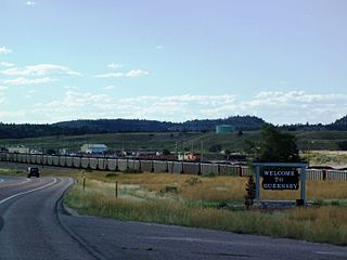
Guernsey is a town in Platte County, Wyoming, United States. The population was 1,147 at the 2010 census.

<span class="mw-page-title-main">Pinedale, Wyoming</span> Town in Wyoming, United States

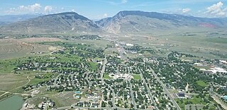
Pinedale is a town in and the county seat of Sublette County, Wyoming, United States. The population was 2,030 at the 2010 census. Pinedale is an important hunting outfitting town and a gateway to the Wind River Mountains. Additionally, Pinedale is near several large natural gas fields, including the Pinedale Anticline and Jonah Field. Attractions include the Museum of the Mountain Man, Green River Rendezvous Days, White Pine Ski Area, the Pinedale Aquatic Center and the Town Park System along the Pine Creek Corridor in the middle of town. The mayor is Matt Murdock, who was elected in 2018.

Arrowhead Springs is a census-designated place (CDP) in Sweetwater County, Wyoming, United States. The population was 63 at the 2010 census.

<span class="mw-page-title-main">Bairoil, Wyoming</span> Town in Wyoming, United States

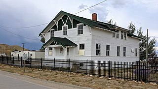
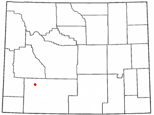
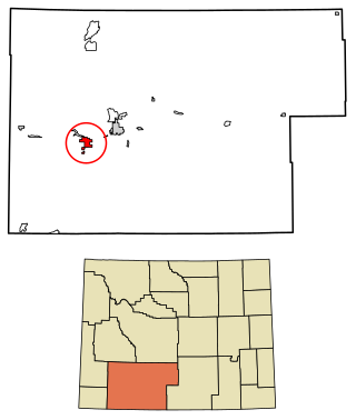
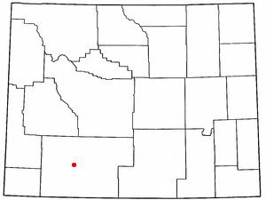
Bairoil is a town in Sweetwater County, Wyoming, United States. The population was 68 at the 2020 census.

<span class="mw-page-title-main">Farson, Wyoming</span> CDP in Wyoming, United States

Farson is a census-designated place (CDP) in Sweetwater County, Wyoming, United States. The population was 313 at the 2010 census.

<span class="mw-page-title-main">Green River, Wyoming</span> City in Wyoming, United States

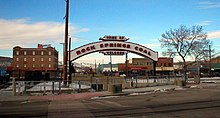
Green River is a city in and the county seat of Sweetwater County, Wyoming, United States, in the southwestern part of the state. The population was 11,825 at the 2020 census. It is the 7th most populous city in Wyoming.

North Rock Springs is a census-designated place (CDP) in Sweetwater County, Wyoming, United States. The population was 2,439 at the 2020 census.

<span class="mw-page-title-main">Reliance, Wyoming</span> CDP in Wyoming, United States

Reliance is a census-designated place (CDP) in Sweetwater County, Wyoming, United States. The population was 714 at the 2010 census.

<span class="mw-page-title-main">Wamsutter, Wyoming</span> Town in Wyoming, United States

Wamsutter is a town in Sweetwater County, Wyoming, United States. The population was 203 at the 2020 census.

<span class="mw-page-title-main">Cheyenne, Wyoming</span> Capital of Wyoming, United States

Cheyenne is the capital and most populous city of the U.S. state of Wyoming, as well as the county seat of Laramie County, with 65,132 residents, per the 2020 census. It is the principal city of the Cheyenne metropolitan statistical area which encompasses all of Laramie County and had 100,512 residents as of the 2020 census. Local residents named the town for the Cheyenne Native American people in 1867 when it was founded in the Dakota Territory. Along with Oklahoma City, Oklahoma and Topeka, Kansas, Cheyenne is one of three state capitals with an indigenous name in a state with an indigenous name.

References

  1. "2019 U.S. Gazetteer Files". United States Census Bureau. Retrieved August 7, 2020.
  2. 1 2 U.S. Geological Survey Geographic Names Information System: Rock Springs, Wyoming
  3. 1 2 "U.S. Census website". United States Census Bureau . Retrieved December 14, 2012.
  4. 1 2 "U.S. Census website". United States Census Bureau . Retrieved January 31, 2008.
  5. "Sweetwater Events Complex". Sweetwater Events Complex. Retrieved January 9, 2018.
  6. Pitcher, Don (June 2, 2006). Wyoming. Avalon Publishing. ISBN   978-1-56691-953-1.
  7. "Whites massacre Chinese in Wyoming Territory - Sep 02, 1885". History.com. Retrieved January 9, 2018.
  8. "Rock Springs Photos". Wyomingtalesandtrails.com. Retrieved January 9, 2018.
  9. "A&E TV Shows - A&E". Aetv.com. Retrieved January 9, 2018.
  10. "US Gazetteer files 2010". United States Census Bureau. Archived from the original on January 25, 2012. Retrieved December 14, 2012.
  11. 1 2 3 "NOAA Online Weather Data". National Weather Service. Retrieved August 20, 2022.
  12. "U.S. Climate Normals Quick Access". National Oceanic and Atmospheric Administration. Retrieved August 20, 2022.
  13. "Historical Decennial Census Population for Wyoming Counties, Cities, and Towns". Wyoming Department of State / U.S. Census Bureau. Retrieved June 30, 2008.
  14. "Home - Downtown Rock Springs". Downtownrs.com. Retrieved January 9, 2018.
  15. "Wyoming Public Libraries". PublicLibraries.com. Retrieved June 14, 2019.
  16. "Sister City Program / City of Rock Springs, Wyoming". www.rswy.net. City of Rock Springs. Retrieved February 5, 2019.
  17. "RootsWeb.com Home Page". Rootsweb.ancestry.com. Retrieved January 9, 2018.
  18. Favaro, Avis (December 7, 2012). "Finding inspiration and encouraging others despite huge disability". CTV News. Retrieved February 27, 2021.