Area code 307

Last updated
Wyoming's numbering plan area and area code (blue) Area code WY.png
Wyoming's numbering plan area and area code (blue)

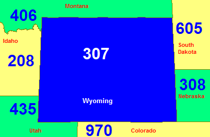
Area code 307 is the telephone area code in the North American Numbering Plan for the entire U.S. state of Wyoming. It is one of the 86 original North American area codes created by the American Telephone and Telegraph Company (AT&T) in 1947.

Contents

Because it is sparsely populated, Wyoming is one of only eleven states (as of April 8, 2020) with only one area code.

Service area

The numbering plan includes the following communities, with their respective central office codes:

See also

Wyoming area codes: 307
North: 406
West: 208/986, 406, 435 307East: 605, 308
South: 435, 970
Colorado area codes: 303/720, 719, 970
Utah area codes: 385/801, 435
Idaho area codes: 208/986
Montana area codes: 406
South Dakota area codes: 605
Nebraska area codes: 308, 402/531

43°00′N107°30′W / 43.000°N 107.500°W / 43.000; -107.500

Related Research Articles

<span class="mw-page-title-main">Wyoming</span> U.S. state

Wyoming is a state in the Mountain West subregion of the Western United States. It is bordered by Montana to the north and northwest, South Dakota and Nebraska to the east, Idaho to the west, Utah to the southwest, and Colorado to the south. With a population of 576,851 in the 2020 United States census, Wyoming is the least populous state despite being the 10th largest by area, with the second-lowest population density after Alaska. The state capital and most populous city is Cheyenne, which had an estimated population of 63,957 in 2018.

<span class="mw-page-title-main">Hot Springs County, Wyoming</span> County in Wyoming, United States

Hot Springs County is a county in the U.S. state of Wyoming. As of the 2020 United States Census, the population was 4,696, making it the second-least populous county in Wyoming. Its county seat is Thermopolis. The county is named for the hot springs located in Hot Springs State Park.

<span class="mw-page-title-main">Thermopolis, Wyoming</span> Town in Wyoming, United States

Thermopolis is the county seat and largest town in Hot Springs County, Wyoming, United States. As of the 2020 U.S. Census, the town population was 2,725.

<span class="mw-page-title-main">Bridger Mountains (Wyoming)</span> Subrange of the Rocky Mountains

The Bridger Mountains are a short subrange of the Rocky Mountains, approximately 40 miles (64 km) long, in central Wyoming in the United States. The range forms a bridge between the Owl Creek Mountains to the west and the southern end of the Bighorn Mountains to the east. The Wind River passes through the gap between the range and the Owl Creek Mountains. Bridger Creek passes through the gap between the range and the Bighorns. The highest point in the range is Copper Mountain at 8,300 feet (2,500 m).

<span class="mw-page-title-main">Bighorn Basin</span>

The Bighorn Basin is a plateau region and intermontane basin, approximately 100 miles (160 km) wide, in north-central Wyoming in the United States. It is bounded by the Absaroka Range on the west, the Pryor Mountains on the north, the Bighorn Mountains on the east, and the Owl Creek Mountains and Bridger Mountains on the south. It is drained to the north by tributaries of the Bighorn River, which enters the basin from the south, through a gap between the Owl Creek and Bridger Mountains, as the Wind River, and becomes the Bighorn as it enters the basin. The region is semi-arid, receiving only 6–10 in (15–25 cm) of rain annually.

Area codes 519, 226, 548, and 382 are overlay telephone area codes in the North American Numbering Plan (NANP) for most of southwestern Ontario.

<span class="mw-page-title-main">Area code 701</span> Area code for North Dakota, United States

Area code 701 is a telephone area code in the North American Numbering Plan (NANP) for the U.S. State of North Dakota. It is one of the 86 original North American area codes created by AT&T in 1947, and continues to be the only area code in North Dakota, one of eleven states with only one area code.

<span class="mw-page-title-main">Great Divide Basin</span> Endorheic basin adjoining the Continental Divide in southern Wyoming, USA

The Great Divide Basin or Great Divide Closed Basin is an area of land in the Red Desert of Wyoming where none of the water falling as rain to the ground drains into any ocean, directly or indirectly. It is thus an endorheic basin, one of several in the United States that adjoin the Continental Divide. To the south and west of the basin is the Green River watershed, draining to the Gulf of California/Pacific Ocean; to the north and east is the North Platte watershed, draining to the Gulf of Mexico/Atlantic Ocean. The basin is very roughly rectangular in shape; the northwest corner is at Oregon Buttes near South Pass, about 40 miles (64 km) southwest of Lander, and the southeast corner is in the Sierra Madre Range near Bridger Pass, about 20 miles (32 km) southwest of Rawlins.

Area codes 778, 236, and 672 are telephone area codes in the North American Numbering Plan (NANP) for the Canadian province of British Columbia. They form an overlay complex with area code 604, which serves only a small southwestern section, the Lower Mainland, of the province, and area code 250, which serves the rest of the province.

<span class="mw-page-title-main">Area code 780</span> Telephone area code for central and northern Alberta

Area code 780 is a telephone area code in the North American Numbering Plan (NANP) for the Canadian province of Alberta. The numbering plan area comprises the northern two thirds of the province, including the Edmonton area. The area code was established in 1999 in a split of area code 403, which had served the entire province since the establishment of the original North American area codes in 1947. The numbering plan area is also served by area codes 587, 825, and 368, which form a complex overlay for all of Alberta.

<span class="mw-page-title-main">Area code 605</span> Area code for South Dakota, United States

Area code 605 is the telephone area code in the North American Numbering Plan for the entire U.S. state of South Dakota. The numbering plan area was designated in 1947, when the American Telephone and Telegraph Company (AT&T) devised a comprehensive telephone numbering plan for the United States and Canada.

<span class="mw-page-title-main">Wind River Canyon</span>

<span class="mw-page-title-main">KRVK</span> Radio station in Vista West, Wyoming

KRVK is a commercial radio station licensed to Vista West, Wyoming, broadcasting to the Casper, Wyoming area. KRVK airs an adult hits music format branded as "Jack FM". When the station first signed on in 1998, it was broadcasting on 107.7 FM. KRVK is owned and operated by Townsquare Media.

<span class="mw-page-title-main">Bridger Trail</span> United States historic place

The Bridger Trail, also known as the Bridger Road and Bridger Immigrant Road, was an overland route connecting the Oregon Trail to the gold fields of Montana. Gold was discovered in Virginia City, Montana in 1863, prompting settlers and prospectors to find a trail to travel from central Wyoming to Montana. In 1863, John Bozeman and John Jacobs scouted the Bozeman Trail, which was a direct route to the Montana gold fields through the Powder River Country. At the time the region was controlled by the Sioux, Cheyenne and Arapaho, who stepped up their raids in response to the stream of settlers along the trail.

<span class="mw-page-title-main">Legend Rock</span> United States historic place

Legend Rock Petroglyph Site is located in Hot Springs County, Wyoming, 20 miles northwest of Hot Springs State Park. Legend Rock is a petroglyph site which features hundreds of individual petroglyphs spread across the face of the rock. Although a handful of the rock's etchings have variously been eroded and defaced, a wide majority have been preserved for public viewing. The nearly 300 individual petroglyphs feature some of the oldest and best examples of Dinwoody rock art in the world. The origins of the petroglyphs are still subject to debate. The site was listed on the National Register of Historic Places on July 5, 1973 and it is preserved by the state of Wyoming as a state historic site.

<span class="mw-page-title-main">Wind River Basin</span> Basin in Wyoming, United States

The Wind River Basin or Shoshone Basin is a semi-arid intermontane foreland basin in central Wyoming, United States. It is bounded by Laramide uplifts on all sides. On the west is the Wind River Range and on the North are the Absaroka Range and the Owl Creek Mountains. The Casper Arch separates the Wind River from the Powder River Basin to the east and the Sweetwater Uplift lies to the south. The basin contains a sequence of 10,000–12,000 feet of predominantly marine sediments deposited during the Paleozoic and Mesozoic Eras. During the Laramide over 18,000 feet of Eocene lacustrine and fluvial sediments were deposited within the basin. Following the Eocene an additional 3,000 feet of sediments were deposited before, and as the basin was uplifted in the late Tertiary.

<span class="mw-page-title-main">Anchor Dam</span> Dam in Hot Springs County, Wyoming

Anchor Dam is a dam in Hot Springs County, about 35 miles (56 km) west of Thermopolis, Wyoming.

The Thermopolis Shale is a geologic formation which formed in west-central North America in the Albian age of the Late Cretaceous period. Surface outcroppings occur in central Canada, and the U.S. states of Montana and Wyoming. The rock formation was laid down over about 7 million years by sediment flowing into the Western Interior Seaway. The formation's boundaries and members are not well-defined by geologists, which has led to different definitions of the formation. Some geologists conclude the formation should not have a designation independent of the formations above and below it. A range of invertebrate and small and large vertebrate fossils and coprolites are found in the formation.

Border Junction or Border is a populated place and road intersection in the far western part of Lincoln County, Wyoming, United States. US Route 30 is the major road, which leads northwest to Montpelier, Idaho, in Bear Lake County, and southeast to Cokeville. Wyoming Highway 89 runs north toward US Route 89, and southeast concurrently with US 30. Lincoln County Road 134 runs briefly south toward some homes and ranches. The Union Pacific Railroad passes Border Junction in the direction of Rock Springs to the east and Pocatello, Idaho, to the west.