Wheatland, Wyoming

Last updated

Wheatland, Wyoming
Wheatland Wyoming 9th St.jpg
Downtown Wheatland
Platte County Wyoming Incorporated and Unincorporated areas Wheatland Highlighted 5683040.svg
Location of Wheatland in Platte County, Wyoming.
Usa edcp location map.svg
Red pog.svg
Wheatland, Wyoming
Location in the United States
Coordinates: 42°3′14″N104°57′34″W / 42.05389°N 104.95944°W / 42.05389; -104.95944
Country Flag of the United States.svg  United States
State Flag of Wyoming.svg  Wyoming
County Flag of Platte County, Wyoming.gif Platte
Area
[1]
  Total4.10 sq mi (10.61 km2)
  Land4.10 sq mi (10.61 km2)
  Water0.00 sq mi (0.00 km2)
Elevation
4,751 ft (1,448 m)
Population
 (2020) [2]
  Total3,588
  Density875.5/sq mi (338.1/km2)
Time zone UTC-7 (Mountain (MST))
  Summer (DST) UTC-6 (MDT)
ZIP code
82201
Area code 307
FIPS code 56-83040 [3]
GNIS feature ID1609173 [4]
Website Official website

Wheatland is a town in and the county seat of Platte County in southeastern Wyoming, United States. [5] The population was 3,627 at the 2010 census.

Contents

History

Before the late 19th century, the area around the future site of Wheatland was a flat, arid landscape with desert-like vegetation. In 1883 local rancher and judge Joseph M. Carey, along with Horace Plunkett, John Hoyt, Morton Post, Francis E. Warren, William Irvine, and Andrew Gilchrist, established the Wyoming Development Company. The company hoped to irrigate in the Wheatland Flats and profit from new development. [6]

By the fall of 1883 an irrigation system was constructed on the Wheatland flats including a 2,380 foot long tunnel to divert water for irrigation into Bluegrass Creek and the first two of the system's canals. [7] The Cheyenne and Northern Railway line reached the Wheatland flats in July 1887, eventually extending to the Wyoming Central Railway at Wendover. The line was eventually sold to the Colorado and Southern Railway, controlled by the Chicago, Burlington, and Quincy Railroad, and operated at Wheatland station. Lots in the town of Wheatland were auctioned in 1894. By 1915 many farms were established in the irrigation district and the population of the flats was 5,277. [6]

In 1911 Platte County was created from a portion of Albany County, and Wheatland was selected as the county seat. [8] The Platte County Courthouse was built in Wheatland in 1917.

The Wheatland Irrigation District is still the largest privately owned irrigation system in the country. [9]

Geography

Wheatland City Hall Wheatland City Hall.jpg
Wheatland City Hall

Wheatland is located at 42°3′14″N104°57′34″W / 42.05389°N 104.95944°W / 42.05389; -104.95944 (42.053917, –104.959460). [10] According to the United States Census Bureau, the town has a total area of 4.10 square miles (10.62 km2), all land. [11]

Demographics

Historical population
CensusPop.Note
1910 796
1920 1,33667.8%
1930 1,99749.5%
1940 2,1105.7%
1950 2,2868.3%
1960 2,3502.8%
1970 2,4986.3%
1980 5,816132.8%
1990 3,271−43.8%
2000 3,5488.5%
2010 3,6272.2%
2020 3,588−1.1%
U.S. Decennial Census

2010 census

As of the census [12] of 2010, there were 3,627 people, 1,657 households, and 974 families living in the town. The population density was 884.6 inhabitants per square mile (341.5/km2). There were 1,879 housing units at an average density of 458.3 per square mile (177.0/km2). The racial makeup of the town was 95.1% White, 0.1% African American, 0.4% Native American, 0.7% Asian, 2.1% from other races, and 1.6% from two or more races. Hispanic or Latino of any race were 7.4% of the population.

There were 1,657 households, of which 25.0% had children under the age of 18 living with them, 46.0% were married couples living together, 8.8% had a female householder with no husband present, 3.9% had a male householder with no wife present, and 41.2% were non-families. 37.5% of all households were made up of individuals, and 19.3% had someone living alone who was 65 years of age or older. The average household size was 2.13 and the average family size was 2.78.

The median age in the town was 45.4 years. 20.7% of residents were under the age of 18; 7.1% were between the ages of 18 and 24; 21.6% were from 25 to 44; 28.3% were from 45 to 64; and 22.3% were 65 years of age or older. The gender makeup of the town was 48.7% male and 51.3% female.

2000 census

City limits Wheatland, WY city limits sign.jpg
City limits

As of the census [3] of 2000, there were 3,548 people, 1,539 households, and 980 families living in the town. The population density was 837.6 people per square mile (323.1/km2). There were 1,764 housing units at an average density of 416.4 per square mile (160.6/km2). The racial makeup of the town was 96.00% White, 0.31% African American, 0.68% Native American, 0.34% Asian, 1.89% from other races, and 0.79% from two or more races. Hispanic or Latino of any race were 6.54% of the population.

There were 1,539 households, out of which 27.0% had children under the age of 18 living with them, 52.7% were married couples living together, 7.9% had a female householder with no husband present, and 36.3% were non-families. 32.2% of all households were made up of individuals, and 16.8% had someone living alone who was 65 years of age or older. The average household size was 2.24 and the average family size was 2.83.

In the town, the population was spread out, with 22.8% under the age of 18, 7.2% from 18 to 24, 22.7% from 25 to 44, 26.5% from 45 to 64, and 20.8% who were 65 years of age or older. The median age was 43 years. For every 100 females, there were 89.5 males. For every 100 females age 18 and over, there were 88.8 males.

The median income for a household in the town was $35,208, and the median income for a family was $42,623. Males had a median income of $34,940 versus $20,185 for females. The per capita income for the town was $19,069. About 6.9% of families and 8.9% of the population were below the poverty line, including 9.9% of those under age 18 and 8.6% of those age 65 or over.

Climate

Wheatland experiences a semi-arid climate (Köppen BSk) with cold, dry winters and hot, wetter summers.

Climate data for Wheatland 4N, Wyoming (1991–2020 normals, extremes 1893–present)
MonthJanFebMarAprMayJunJulAugSepOctNovDecYear
Record high °F (°C)70
(21)
74
(23)
86
(30)
91
(33)
98
(37)
108
(42)
107
(42)
112
(44)
101
(38)
92
(33)
86
(30)
76
(24)
112
(44)
Mean maximum °F (°C)60.2
(15.7)
63.2
(17.3)
74.2
(23.4)
80.9
(27.2)
88.9
(31.6)
95.7
(35.4)
99.9
(37.7)
98.0
(36.7)
94.2
(34.6)
84.2
(29.0)
70.7
(21.5)
61.7
(16.5)
100.6
(38.1)
Mean daily maximum °F (°C)43.3
(6.3)
45.1
(7.3)
55.4
(13.0)
62.1
(16.7)
71.1
(21.7)
82.7
(28.2)
90.3
(32.4)
89.0
(31.7)
80.2
(26.8)
65.6
(18.7)
52.4
(11.3)
42.8
(6.0)
65.0
(18.3)
Daily mean °F (°C)30.0
(−1.1)
30.8
(−0.7)
39.8
(4.3)
46.1
(7.8)
55.1
(12.8)
65.4
(18.6)
72.2
(22.3)
70.5
(21.4)
61.6
(16.4)
48.8
(9.3)
38.0
(3.3)
29.5
(−1.4)
49.0
(9.4)
Mean daily minimum °F (°C)16.6
(−8.6)
16.5
(−8.6)
24.1
(−4.4)
30.0
(−1.1)
39.2
(4.0)
48.0
(8.9)
54.1
(12.3)
52.0
(11.1)
43.1
(6.2)
32.0
(0.0)
23.7
(−4.6)
16.2
(−8.8)
33.0
(0.6)
Mean minimum °F (°C)−12.2
(−24.6)
−6.1
(−21.2)
5.7
(−14.6)
15.8
(−9.0)
26.8
(−2.9)
39.2
(4.0)
45.6
(7.6)
42.9
(6.1)
31.0
(−0.6)
15.1
(−9.4)
−0.4
(−18.0)
−10.0
(−23.3)
−19.5
(−28.6)
Record low °F (°C)−36
(−38)
−36
(−38)
−25
(−32)
−22
(−30)
13
(−11)
28
(−2)
29
(−2)
25
(−4)
12
(−11)
−9
(−23)
−19
(−28)
−39
(−39)
−39
(−39)
Average precipitation inches (mm)0.28
(7.1)
0.42
(11)
0.74
(19)
1.70
(43)
2.70
(69)
2.12
(54)
1.73
(44)
1.17
(30)
1.29
(33)
1.14
(29)
0.45
(11)
0.39
(9.9)
14.13
(359)
Average snowfall inches (cm)4.6
(12)
7.8
(20)
7.4
(19)
5.4
(14)
1.4
(3.6)
0.0
(0.0)
0.0
(0.0)
0.0
(0.0)
0.1
(0.25)
3.2
(8.1)
4.3
(11)
5.7
(14)
39.9
(101)
Average precipitation days (≥ 0.01 in)2.73.43.65.77.87.56.35.85.44.33.02.858.3
Average snowy days (≥ 0.1 in)2.73.22.82.00.60.00.00.00.21.12.43.118.1
Source: NOAA [13] [14]

Education

Public education in the town of Wheatland is provided by Platte County School District #1. Campuses serving the town include Libbey Elementary School (grades K–2), West Elementary School (grades 3–5), Wheatland Middle School (grades 6–8), and Wheatland High School (grades 9–12).

Wheatland has a public library, a branch of the Platte County Public Library System. [15]

Transport

Highways

Transit

Intercity bus service to the city is provided by Express Arrow. [16]

Air Transport

Wheatland is served by Phifer Airfield just east of town on State Route 316 (Gilchrist St./Antelope Gap Rd.). However, the field has no direct commercial service, residents can choose between Western Nebraska Regional Airport, Casper–Natrona County International Airport, and Cheyenne Regional Airport.

Railroads

Wheatland is the home of the historical Wheatland station, then operated by Union Pacific, Denver and Gulf Railway. The station is not open today for revenue service, though the tracks through Wheatland are currently owned and used by Berkshire Hathaway's BNSF Railway after a series of acquisitions which gave BNSF the Wheatland assets formerly operated by Union Pacific, Denver and Gulf. BNSF currently has small offices located in Wheatland. [17] [18]

Arts and culture

Wheatland hosts the annual Platte County Fair & Rodeo, usually held the second full week of August, at the fairgrounds on the east edge of town at Front Street and Antelope Gap Road. [19]

The horse Steamboat, the model for the bucking horse and rider motif on the Wyoming license, was stabled near Wheatland in a barn owned and maintained as a historical structure by Mike and Linda Holst. Steamboat is also the logo for the University of Wyoming. [20] [21]

Notable people

Related Research Articles

<span class="mw-page-title-main">Casper, Wyoming</span> City in Wyoming, United States

Casper is a city in, and the county seat of, Natrona County, Wyoming, United States. Casper is the second-most populous city in the state after Cheyenne, with the population at 59,038 as of the 2020 census. Casper is nicknamed "The Oil City" and has a long history of oil boomtown and cowboy culture, dating back to the development of the nearby Salt Creek Oil Field.

<span class="mw-page-title-main">Platte County, Wyoming</span> County in Wyoming, United States

Platte County is a county located in the U.S. state of Wyoming. As of the 2020 United States Census, the population was 8,605. Its county seat is Wheatland.

<span class="mw-page-title-main">Niobrara County, Wyoming</span> County in the United States

Niobrara County is a county in the U.S. state of Wyoming. As of the 2020 United States Census, the population was 2,467, making it the least populous county in Wyoming. Its county seat is Lusk. Its eastern boundary abuts the west lines of the states of Nebraska and South Dakota.

<span class="mw-page-title-main">Laramie County, Wyoming</span> County in Wyoming, United States

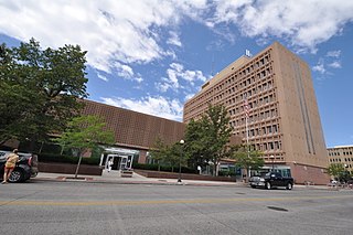
Laramie County is a county located at the southeast corner of the state of Wyoming. As of the 2020 United States Census, the population was 100,512 or 17.4% of the state's total 2020 population, making it the most populous county in Wyoming, but the least populous county in the United States to be the most populous in its state.

<span class="mw-page-title-main">Goshen County, Wyoming</span> County in Wyoming, United States

Goshen County is a county in the U.S. state of Wyoming. As of the 2020 United States Census, the population was 12,498. Its county seat is Torrington. The eastern boundary of the County borders the Nebraska state line.

<span class="mw-page-title-main">Banner County, Nebraska</span> County in Nebraska, United States

Banner County is a county in the western part of the U.S. state of Nebraska in the Great Plains region of the United States. As of the 2020 United States Census, its population was 674. Its county seat is the unincorporated community of Harrisburg; there are no incorporated municipalities within the county.

<span class="mw-page-title-main">Gove City, Kansas</span> City in Gove County, Kansas

Gove City, more commonly known as Gove, is a city in and the county seat of Gove County, Kansas, United States. As of the 2020 census, the population of the city was 80.

<span class="mw-page-title-main">Edgemont, South Dakota</span> City in South Dakota, United States

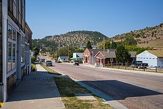
Edgemont is a city in Fall River County, South Dakota, United States. The population was 725 at the 2020 census. The city lies on the far southern edge of the Black Hills in southwestern South Dakota.

<span class="mw-page-title-main">Wheatland, Kenosha County, Wisconsin</span> Town in Wisconsin, United States

Wheatland is a town in Kenosha County, Wisconsin, United States. The population was 3,391 at the 2020 census. The census-designated place of Powers Lake is located partially in the town. The unincorporated communities of Lily Lake, New Munster, and Slades Corners are also located in the town.

<span class="mw-page-title-main">Fort Laramie, Wyoming</span> Town in Wyoming, United States

Fort Laramie is a town in Goshen County, Wyoming, United States. The population was 206 at the 2020 census. The town is named after historic Fort Laramie, an important stop on the Oregon, California and Mormon trails, as well as a staging point for various military excursions and treaty signings. The old fort was located south of town across the North Platte River, at the mouth of the Laramie River.

<span class="mw-page-title-main">Huntley, Wyoming</span> CDP in Wyoming, United States

Huntley is a census-designated place (CDP) in Goshen County, Wyoming, United States. The population was 30 according to the 2010 census.

<span class="mw-page-title-main">Lingle, Wyoming</span> Town in Wyoming, United States

Lingle is a town in Goshen County, Wyoming, United States. The population was 468 at the 2010 census.

<span class="mw-page-title-main">Torrington, Wyoming</span> City in Wyoming, United States

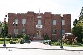
Torrington is a city in, and the county seat of, Goshen County, Wyoming, United States. The population was 6,501 at the 2010 census.

<span class="mw-page-title-main">Lance Creek, Wyoming</span> CDP in Wyoming, United States

Lance Creek is a census-designated place (CDP) in Niobrara County, Wyoming, United States. The population was 43 at the 2010 census. Lance Creek is the namesake of the Lance Formation, a rock formation from the Late Cretaceous that has yielded fossils from a diverse number of species.

<span class="mw-page-title-main">Van Tassell, Wyoming</span> Town in Wyoming, United States

Van Tassell is a town in Niobrara County, Wyoming, United States. The population was 15 at the 2010 census.

<span class="mw-page-title-main">Chugwater, Wyoming</span> Town in Wyoming, United States

Chugwater is a town in Platte County, Wyoming, United States. As of the 2020 census, the town population was 175. The High Plains town, located 45 miles north of Cheyenne and 25 miles south of Wheatland.

<span class="mw-page-title-main">Guernsey, Wyoming</span> Town in Wyoming, United States

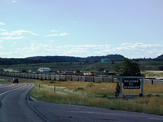
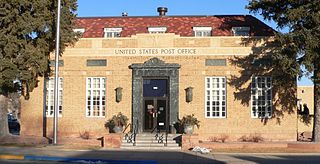
Guernsey is a town in Platte County, Wyoming, United States. The population was 1,147 at the 2010 census.

<span class="mw-page-title-main">Hartville, Wyoming</span> Town in Wyoming, United States

Hartville is a town in Platte County, Wyoming, United States. The population was 62 at the 2010 census.

<span class="mw-page-title-main">Westview Circle, Wyoming</span> CDP in Wyoming, United States

Westview Circle is a census-designated place (CDP) in Platte County, Wyoming, United States. The population was 52 at the 2010 census.

<span class="mw-page-title-main">Cheyenne, Wyoming</span> Capital of Wyoming, United States

Cheyenne is the capital and most populous city of the U.S. state of Wyoming, as well as the county seat of Laramie County, with 65,132 residents, per the 2020 census. It is the principal city of the Cheyenne metropolitan statistical area which encompasses all of Laramie County and had 100,512 residents as of the 2020 census. Local residents named the town for the Cheyenne Native American people in 1867 when it was founded in the Dakota Territory. Along with Oklahoma City, Oklahoma and Topeka, Kansas, Cheyenne is one of three state capitals with an indigenous name in a state with an indigenous name.

References

  1. "2020 U.S. Gazetteer Files". United States Census Bureau. Retrieved March 22, 2024.
  2. "Profile of General Population and Housing Characteristics: 2020 Demographic Profile Data (DP-1): Wheatland city, Wyoming". United States Census Bureau . Retrieved March 22, 2024.
  3. 1 2 "U.S. Census website". United States Census Bureau . Retrieved January 31, 2008.
  4. "US Board on Geographic Names". United States Geological Survey. October 25, 2007. Retrieved January 31, 2008.
  5. "Find a County". National Association of Counties. Retrieved June 7, 2011.
  6. 1 2 "National Register of Historic Places Registration, Wheatland Railroad Depot". United States Department of the Interior.
  7. Owens, Clyde. Studies in the Settlement and Economic Development of Wyoming. Annals of Wyoming, 1932. Vol. 8, No. 2, pp. 546-554.
  8. Long, John H. (2006). "Wyoming: Individual County Chronologies". Wyoming Atlas of Historical County Boundaries. The Newberry Library. Retrieved July 10, 2012.
  9. "Community Profile" (PDF). Platte County Chamber of Commerce.
  10. "US Gazetteer files: 2010, 2000, and 1990". United States Census Bureau. February 12, 2011. Retrieved April 23, 2011.
  11. "US Gazetteer files 2010". United States Census Bureau . Retrieved December 14, 2012.
  12. "U.S. Census website". United States Census Bureau . Retrieved December 14, 2012.
  13. "NOWData – NOAA Online Weather Data". National Oceanic and Atmospheric Administration. Retrieved December 10, 2021.
  14. "Station: Wheatland 4 N, WY". U.S. Climate Normals 2020: U.S. Monthly Climate Normals (1991–2020). National Oceanic and Atmospheric Administration. Retrieved December 10, 2021.
  15. "Wyoming Public Libraries". PublicLibraries.com. Retrieved June 14, 2019.
  16. "Express Arrow Locations" . Retrieved July 20, 2023.
  17. "Railroad Photos by Mike Yuhas: Wheatland, Wyoming, 3/22/2007". www.mikeyuhas.org. Retrieved October 27, 2022.
  18. "BNSF Railway in Wheatland , WY". YP.com. Retrieved October 27, 2022.
  19. Platte County Chamber of Commerce: Wheatland - The Platte County Fair & Rodeo tops the list of major events, usually held the second full week of August. Retrieved July 6, 2015
  20. "Kelsey Bray, Blazin' saddle". Wyoming Tribune-Eagle . Retrieved September 23, 2013.
  21. "Historical Information Wyoming Secretary of State".