Westview Circle, Wyoming

Last updated

Westview Circle, Wyoming
CDP
Platte County Wyoming incorporated and unincorporated areas Westview Circle highlighted.svg
Location in Platte County and the state of Wyoming.
Usa edcp location map.svg
Red pog.svg
Westview Circle, Wyoming
Location in the United States
Coordinates: 42°4′16″N105°3′50″W / 42.07111°N 105.06389°W / 42.07111; -105.06389
Country United States
State Wyoming
County Platte
Area
  Total2.3 sq mi (6.0 km2)
  Land2.3 sq mi (5.9 km2)
  Water0.0 sq mi (0.1 km2)
Elevation
4,731 ft (1,442 m)
Population
 (2010) [1]
  Total52
  Density23/sq mi (8.7/km2)
Time zone UTC-7 (Mountain (MST))
  Summer (DST) UTC-6 (MDT)
Area code 307
FIPS code 56-82967 [2]
GNIS feature ID1853219 [3]

Westview Circle is a census-designated place (CDP) in Platte County, Wyoming, United States. The population was 52 at the 2010 census.

Contents

Geography

Westview Circle is located at 42°4′16″N105°3′50″W / 42.07111°N 105.06389°W / 42.07111; -105.06389 (42.071160, -105.063915). [4]

According to the United States Census Bureau, the CDP has a total area of 2.3 square miles (6.0 km2), of which 2.3 square miles (5.9 km2) is land and 0.04 square mile (0.1 km2) (1.58%) is water. [5]

Demographics

As of the census [2] of 2000, there were 67 people, 25 households, and 22 families residing in the CDP. The population density was 29.5 people per square mile (11.4/km2). There were 25 housing units at an average density of 11.0/sq mi (4.3/km2). The racial makeup of the CDP was 100.00% White.

There were 25 households, out of which 40.0% had children under the age of 18 living with them, 84.0% were married couples living together, 4.0% had a female householder with no husband present, and 12.0% were non-families. 12.0% of all households were made up of individuals, and 4.0% had someone living alone who was 65 years of age or older. The average household size was 2.68 and the average family size was 2.91.

In the CDP, the population was spread out, with 31.3% under the age of 18, 26.9% from 25 to 44, 29.9% from 45 to 64, and 11.9% who were 65 years of age or older. The median age was 40 years. For every 100 females, there were 91.4 males. For every 100 females age 18 and over, there were 91.7 males.

The median income for a household in the CDP was $40,714, and the median income for a family was $42,321. Males had a median income of $36,500 versus $31,250 for females. The per capita income for the CDP was $16,782. None of the population or the families were below the poverty line.

Education

Public education in the community of Westview Circle is provided by Platte County School District #1.

Related Research Articles

<span class="mw-page-title-main">Platte County, Wyoming</span> County in Wyoming, United States

Platte County is a county located in the U.S. state of Wyoming. As of the 2020 United States Census, the population was 8,605. Its county seat is Wheatland.

<span class="mw-page-title-main">Chilchinbito, Arizona</span> CDP in Navajo County, Arizona

Chilchinbito is a town located on the Navajo Nation, whose lands spans four state boundary lines in the Four Corners region of the United States. The town of Chilchinbito is a census-designated place (CDP) specifically in Navajo County, Arizona, United States. The population was 506 at the 2010 census. Chilchinbito is also considered to be the source of coronavirus infections on the Navajo Nation, possibly traced to the annual meeting of the Church of the Nazarene's numerous branches, on March 7, 2020. COVID-19 federal relief funds for medical care on the Navajo Nation were being redirected to a non-Native for-profit corporation, and a legal suit is pending.

<span class="mw-page-title-main">Westview, Florida</span> Census-designated place in Florida, United States

Westview is a census-designated place (CDP) in Miami-Dade County, Florida, United States. The population was 9,923 at the 2020 census.

<span class="mw-page-title-main">St. Lucas, Iowa</span> City in Iowa, United States

St. Lucas is a city in Fayette County, Iowa, United States. The population was 167 at the time of the 2020 census.

<span class="mw-page-title-main">Ballenger Creek, Maryland</span> Census-designated place in Maryland

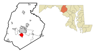
Ballenger Creek is an unincorporated community and census-designated place (CDP) in Frederick County, Maryland, United States. It is a part of the Frederick, Maryland urban area and is adjacent to Frederick's southern city limits. The CDP had a 2010 census population of 18,274.

<span class="mw-page-title-main">Level Park–Oak Park, Michigan</span> Census-designated place & unincorporated community in Michigan, United States

Level Park–Oak Park is a census-designated place for statistical purposes in Calhoun County in the U.S. state of Michigan. The CDP population was 3,409 at the 2010 census. The CDP is immediately northwest of the city of Battle Creek and is part of the Battle Creek Metropolitan Statistical Area.

Brices Creek is an unincorporated area and census-designated place (CDP) in Craven County, North Carolina, United States. The population was 3,073 at the 2010 census. It is part of the New Bern, North Carolina Metropolitan Statistical Area.

<span class="mw-page-title-main">Delano, Pennsylvania</span> CDP in Pennsylvania, United States

Delano is a census-designated place (CDP) in Schuylkill County, Pennsylvania, United States. The population was 377 at the 2000 census.

<span class="mw-page-title-main">Susquehanna Trails, Pennsylvania</span> CDP in Pennsylvania, United States

Susquehanna Trails is a census-designated place (CDP) in York County, Pennsylvania, United States. The population was 2,264 at the 2010 census.

<span class="mw-page-title-main">Albany, Wyoming</span> CDP in Wyoming, United States

Albany is a census-designated place (CDP) in Albany County, Wyoming, United States. The population was 55 at the 2010 census.

<span class="mw-page-title-main">Arapahoe, Wyoming</span> Census-designated place in Wyoming, United States

Arapahoe is a census-designated place (CDP) in Fremont County, Wyoming, United States. The population was 1,656 at the 2010 census. A Catholic mission was founded here in 1884. St Stephen's Mission Church, located near Arapahoe, is part of the Catholic mission.

Homa Hills is a census-designated place (CDP) in Natrona County, Wyoming, United States. It is part of the Casper, Wyoming Metropolitan Statistical Area. The population was 278 at the 2010 census.

<span class="mw-page-title-main">Chugcreek, Wyoming</span> CDP in Wyoming, United States

Chugcreek is a census-designated place (CDP) in Platte County, Wyoming, United States. The population was 156 at the 2010 census.

<span class="mw-page-title-main">Lakeview North, Wyoming</span> CDP in Wyoming, United States

Lakeview North is a census-designated place (CDP) in Platte County, Wyoming, United States. The population was 84 at the 2010 census.

<span class="mw-page-title-main">Slater, Wyoming</span> CDP in Wyoming, United States

Slater is a census-designated place (CDP) in Platte County, Wyoming, United States. The population was 80 at the 2010 census.

<span class="mw-page-title-main">Y-O Ranch, Wyoming</span> CDP in Wyoming, United States

Y-O Ranch is a census-designated place (CDP) in Platte County, Wyoming, United States. The population was 195 at the 2010 census.

<span class="mw-page-title-main">Eden, Wyoming</span> CDP in Wyoming, United States

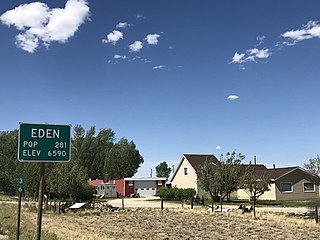
Eden is a census-designated place (CDP) in Sweetwater County, Wyoming, United States. The population was 281 at the 2010 census.

<span class="mw-page-title-main">Sturbridge (CDP), Massachusetts</span> CDP in Massachusetts, United States

Sturbridge is a census-designated place (CDP) in the town of Sturbridge in Worcester County, Massachusetts, United States. The population was 2,253 at the 2010 census.

<span class="mw-page-title-main">Peñasco, New Mexico</span> CDP in New Mexico, United States

Peñasco is a census-designated place (CDP) in Taos County, New Mexico. It is located along the scenic High Road to Taos. The population is estimated at 1,200 (2015).

<span class="mw-page-title-main">Plattekill (CDP), New York</span> CDP in New York, United States

Plattekill is a hamlet in Ulster County, New York, United States. The population was 1,296 at the 2020 census. The community, as is the town, is named after a local stream, the Platte Kill.

References

  1. "2010 City Population and Housing Occupancy Status". U.S. Census Bureau. Retrieved July 13, 2012.[ dead link ]
  2. 1 2 "U.S. Census website". United States Census Bureau . Retrieved January 31, 2008.
  3. "US Board on Geographic Names". United States Geological Survey. October 25, 2007. Retrieved January 31, 2008.
  4. "US Gazetteer files: 2010, 2000, and 1990". United States Census Bureau. February 12, 2011. Retrieved April 23, 2011.
  5. "2010 Wyoming Place Names". U.S. Census Bureau. Retrieved July 13, 2012.