Burlington, Wyoming

Last updated

Burlington, Wyoming
Big Horn County Wyoming Incorporated and Unincorporated areas Burlington Highlighted 5611120.svg
Location of Burlington in Big Horn County, Wyoming.
Usa edcp location map.svg
Red pog.svg
Burlington, Wyoming
Location in the United States
Coordinates: 44°26′46″N108°25′50″W / 44.44611°N 108.43056°W / 44.44611; -108.43056
Country United States
State Wyoming
County Big Horn
Area
[1]
  Total1.01 sq mi (2.62 km2)
  Land1.01 sq mi (2.62 km2)
  Water0.00 sq mi (0.00 km2)
Elevation
4,436 ft (1,352 m)
Population
 (2010) [2]
  Total288
  Estimate 
(2019) [3]
342
  Density338.28/sq mi (130.58/km2)
Time zone UTC-7 (Mountain (MST))
  Summer (DST) UTC-6 (MDT)
ZIP code
82411
Area code 307
FIPS code 56-11120 [4]
GNIS feature ID1597239 [5]

Burlington is a town in Big Horn County, Wyoming, United States. The population was 288 at the 2010 census.

Contents

Geography

According to the United States Census Bureau, the town has a total area of 1.01 square miles (2.62 km2), all land. [6]

Demographics

Historical population
CensusPop.Note
1990 184
2000 25035.9%
2010 28815.2%
2019 (est.)342 [3] 18.8%
U.S. Decennial Census [7]

Burlington's mascot is the husky.

2010 census

As of the census [2] of 2010, there were 288 people, 86 households, and 68 families living in the town. The population density was 285.1 inhabitants per square mile (110.1/km2). There were 95 housing units at an average density of 94.1 per square mile (36.3/km2). The racial makeup of the town was 91.3% White, 0.3% African American, 0.3% Asian, 6.6% from other races, and 1.4% from two or more races. Hispanic or Latino of any race were 13.9% of the population.

There were 86 households, of which 44.2% had children under the age of 18 living with them, 67.4% were married couples living together, 5.8% had a female householder with no husband present, 5.8% had a male householder with no wife present, and 20.9% were non-families. 17.4% of all households were made up of individuals, and 10.5% had someone living alone who was 65 years of age or older. The average household size was 3.35 and the average family size was 3.85.

The median age in the town was 27 years. 39.6% of residents were under the age of 18; 8.7% were between the ages of 18 and 24; 19.1% were from 25 to 44; 18% were from 45 to 64; and 14.6% were 65 years of age or older. The gender makeup of the town was 52.4% male and 47.6% female.

2000 census

As of the census [4] of 2000, there were 250 people, 76 households, and 58 families living in the town. The population density was 246.6 people per square mile (95.6/km2). There were 87 housing units at an average density of 85.8 per square mile (33.3/km2). The racial makeup of the town was 88.80% White, 0.80% Native American, 1.20% Pacific Islander, 8.80% from other races, and 0.40% from two or more races. Hispanic or Latino of any race were 10.00% of the population.

There were 76 households, out of which 46.1% had children under the age of 18 living with them, 71.1% were married couples living together, 5.3% had a female householder with no husband present, and 22.4% were non-families. 21.1% of all households were made up of individuals, and 10.5% had someone living alone who was 65 years of age or older. The average household size was 3.29 and the average family size was 3.90.

In the town, the population was spread out, with 44.4% under the age of 18, 2.8% from 18 to 24, 24.8% from 25 to 44, 13.2% from 45 to 64, and 14.8% who were 65 years of age or older. The median age was 29 years. For every 100 females, there were 101.6 males. For every 100 females age 18 and over, there were 98.6 males.

The median income for a household in the town was $28,281, and the median income for a family was $31,875. Males had a median income of $29,375 versus $15,625 for females. The per capita income for the town was $13,129. About 7.7% of families and 15.1% of the population were below the poverty line, including 19.5% of those under the age of eighteen and 2.4% of those 65 or over.

Education

Public education in the town of Burlington is provided by Big Horn County School District #1. Children attend Burlington Elementary School (grades K-5), Burlington Junior High School (grades 6–8), and Burlington High School (grades 9-12).

Mayor

The mayor of Burlington is Gerald George. [8]

See also

Related Research Articles

<span class="mw-page-title-main">Burlington, Indiana</span> Town in Indiana, United States

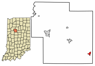
Burlington is a town in Burlington Township, Carroll County, Indiana, United States. The population was 603 at the 2010 census. It is part of the Lafayette, Indiana Metropolitan Statistical Area. State Road 22 connects it to Kokomo.

<span class="mw-page-title-main">Moulton, Iowa</span> City in Iowa, United States

Moulton is a city in Appanoose County, Iowa, United States. The population was 607 at the time of the 2020 census.

<span class="mw-page-title-main">Middletown, Iowa</span> City in Iowa, United States

Middletown is a city in Des Moines County, Iowa, United States. The population was 363 at the time of the 2020 census. It is part of the Burlington, IA–IL Micropolitan Statistical Area.

<span class="mw-page-title-main">West Burlington, Iowa</span> City in Iowa, United States

West Burlington is a city in Des Moines County, Iowa, United States, adjacent to the Mississippi River city of Burlington. The population was 3,197 at the 2020 census. It is part of the Burlington, IA–IL Micropolitan Statistical Area.

<span class="mw-page-title-main">Walker, Iowa</span> City in Iowa, United States

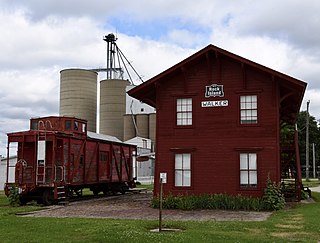
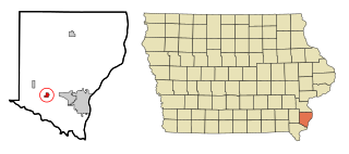
Walker is a city in Linn County, Iowa. The population was 688 at the 2020 census. It is part of the Cedar Rapids, Iowa metropolitan area.

<span class="mw-page-title-main">Emerson, Iowa</span> City in Iowa, United States

Emerson is a city in Mills County, Iowa, United States. The population was 403 at the time of the 2020 census.

<span class="mw-page-title-main">Pacific Junction, Iowa</span> City in Iowa, United States

Pacific Junction is a city in Mills County, Iowa, United States. The population was 96 at the time of the 2020 census.

<span class="mw-page-title-main">Burlington, Kansas</span> City in Coffey County, Kansas, United States

Burlington is a city in and the county seat of Coffey County, Kansas, United States. As of the 2020 census, the population of the city was 2,634.

Sweden is a town in Oxford County, Maine, United States. The population was 406 at the 2020 census. Set among hills, forests and ponds, Sweden includes the village of East Sweden.

Burlington is a town in Penobscot County, Maine, United States. It is part of the Bangor Metropolitan Statistical Area. The population was 373 at the 2020 census.

<span class="mw-page-title-main">Burlington, Michigan</span> Village in Michigan, United States

Burlington is a village in Calhoun County in the U.S. state of Michigan. The population was 281 at the 2020 census. It is part of the Battle Creek, Michigan Metropolitan Statistical Area. The village is located within Burlington Township on M-60.

<span class="mw-page-title-main">Burlington Junction, Missouri</span> City in Missouri, United States

Burlington Junction is a city in Nodaway County, Missouri, United States. The population was 521 at the 2020 census.

<span class="mw-page-title-main">Shickley, Nebraska</span> Village in Nebraska, United States

Shickley is a village in Fillmore County, Nebraska, United States. The population was 343 at the 2020 census.

<span class="mw-page-title-main">Wilcox, Nebraska</span> Village in Nebraska, United States

Wilcox is a village in Kearney County, Nebraska, United States. It is part of the Kearney, Nebraska Micropolitan Statistical Area. The population was 331 at the 2020 census.

<span class="mw-page-title-main">Crete, Nebraska</span> City in Saline County, Nebraska, United States

Crete is a city in and the most populous municipality of Saline County, Nebraska, United States. The population was 7,099 at the 2020 census. The city is home to Doane University.

<span class="mw-page-title-main">Dorchester, Nebraska</span> Village in Nebraska, United States

Dorchester is a village in Saline County, Nebraska, United States. It is thirty-eight miles southwest from the Lincoln, Nebraska metropolitan area. The population was 596 at the 2020 census.

<span class="mw-page-title-main">Des Lacs, North Dakota</span> City in North Dakota, United States

Des Lacs is a city in Ward County, North Dakota, United States. The population was 185 at the 2020 census. It is part of the Minot Micropolitan Statistical Area. Des Lacs was founded in 1888, named after the Riviere de Lacs, from the French for "River [of] The Lakes."

<span class="mw-page-title-main">Pringle, South Dakota</span> Town in South Dakota, United States

Pringle is a town in Custer County, South Dakota, United States. The population was 109 at the 2020 census.

<span class="mw-page-title-main">Manderson, Wyoming</span> Town in Wyoming, United States

Manderson is a town in Big Horn County, Wyoming, United States. The population was 88 at the 2020 census. The town was originally called Alamo, but it was renamed in 1889 in honor of Charles F. Manderson, chief counsel for Burlington Railroad. The town is widely regarded as a speed trap for tourists heading to Yellowstone National Park.

<span class="mw-page-title-main">Burlington (town), Wisconsin</span> Town in Wisconsin, United States

The Town of Burlington is located in Racine County, Wisconsin. The population was 6,465 at the 2020 census. The City of Burlington is located mostly within the town. The census-designated places of Bohners Lake, and Browns Lake are located within the town. The unincorporated community of Cedar Park is also located in the town.

References

  1. "2019 U.S. Gazetteer Files". United States Census Bureau. Retrieved August 7, 2020.
  2. 1 2 "U.S. Census website". United States Census Bureau . Retrieved December 14, 2012.
  3. 1 2 "Population and Housing Unit Estimates". United States Census Bureau. May 24, 2020. Retrieved May 27, 2020.
  4. 1 2 "U.S. Census website". United States Census Bureau . Retrieved January 31, 2008.
  5. "US Board on Geographic Names". United States Geological Survey. October 25, 2007. Retrieved January 31, 2008.
  6. "US Gazetteer files 2010". United States Census Bureau. Archived from the original on January 25, 2012. Retrieved December 14, 2012.
  7. "Census of Population and Housing". Census.gov. Retrieved June 4, 2015.
  8. http://www.bighorncountywy.gov/images/downloads/GENERAL%20ELECTION%20NIGHT%20RESULTS%20BOARD.pdf [ bare URL PDF ]