Hanna, Wyoming

Last updated

Hanna, Wyoming
2009-0722-Hanna.jpg
Aerial view of Hanna and surrounding area
Carbon County Wyoming Incorporated and Unincorporated areas Hanna Highlighted 5635335.svg
Location of Hanna in Carbon County, Wyoming.
Usa edcp location map.svg
Red pog.svg
Hanna, Wyoming
Location in the United States
Coordinates: 41°52′15″N106°33′26″W / 41.87083°N 106.55722°W / 41.87083; -106.55722
Country United States
State Wyoming
County Carbon
Government
  MayorJason Nordquist
Area
[1]
  Total2.04 sq mi (5.30 km2)
  Land2.04 sq mi (5.30 km2)
  Water0.00 sq mi (0.00 km2)
Elevation
6,818 ft (2,078 m)
Population
 (2020) [2]
  Total683
  Estimate 
(2023) [3]
697
  Density376.04/sq mi (145.20/km2)
Time zone UTC-7 (Mountain (MST))
  Summer (DST) UTC-6 (MDT)
ZIP code
82327
Area code 307
FIPS code 56-35335 [4]
GNIS feature ID1589288 [5]

Hanna is a town in Carbon County, Wyoming, United States. The population was 683 at the 2020 census. The town was started as a coal supply location for the Union Pacific Railroad. Much of the old town is built on top of the former workings of the Hanna No. 4 mine. [6] On December 18, 1979, the Town of Hanna annexed the adjacent Town of Elmo. The population peaked at 2,288 in 1980 and has declined as local coal mines have ceased operation. [7]

Contents

Geography

Hanna is located at 41°52′15″N106°33′26″W / 41.87083°N 106.55722°W / 41.87083; -106.55722 (41.870928, -106.557297). [8]

According to the United States Census Bureau, the town has a total area of 2.05 square miles (5.31 km2), all land. [9]

Demographics

Historical population
CensusPop.Note
1940 1,127
1950 1,32617.7%
1960 625−52.9%
1970 460−26.4%
1980 2,288397.4%
1990 1,076−53.0%
2000 873−18.9%
2010 841−3.7%
2020 683−18.8%
2023 (est.)697 [3] 2.0%
U.S. Decennial Census [10]

2020 census

As of the census [2] of 2020, there were 683 people, 301 households, and 208 families living in the town. The population density was 410.2 inhabitants per square mile (158.4/km2). There were 399 housing units at an average density of 242.4 per square mile (93.6/km2). The racial makeup of the town was 95.6% White, 0.7% African American, 0.6% Native American, 1.2% from other races, and 1.9% from two or more races. Hispanic or Latino of any race were 4.0% of the population.

There were 301 households, of which 33.2% had children under the age of 18 living with them, 55.8% were married couples living together, 7.5% had a female householder with no husband present, 3.8% had a male householder with no wife present, and 32.9% were non-families. 28.6% of all households were made up of individuals, and 14.1% had someone living alone who was 65 years of age or older. The average household size was 2.43 and the average family size was 2.97.

The median age in the town was 39.2 years. 26.3% of residents were under the age of 18; 5.9% were between the ages of 18 and 24; 23.7% were from 25 to 44; 27.1% were from 45 to 64; and 17% were 65 years of age or older. The gender makeup of the town was 50.5% male and 49.5% female.

2010 census

As of the census [2] of 2010, there were 841 people, 346 households, and 232 families living in the town. The population density was 410.2 inhabitants per square mile (158.4/km2). There were 497 housing units at an average density of 242.4 per square mile (93.6/km2). The racial makeup of the town was 95.6% White, 0.7% African American, 0.6% Native American, 1.2% from other races, and 1.9% from two or more races. Hispanic or Latino of any race were 4.0% of the population.

There were 346 households, of which 33.2% had children under the age of 18 living with them, 55.8% were married couples living together, 7.5% had a female householder with no husband present, 3.8% had a male householder with no wife present, and 32.9% were non-families. 28.6% of all households were made up of individuals, and 14.1% had someone living alone who was 65 years of age or older. The average household size was 2.43 and the average family size was 2.97.

The median age in the town was 39.2 years. 26.3% of residents were under the age of 18; 5.9% were between the ages of 18 and 24; 23.7% were from 25 to 44; 27.1% were from 45 to 64; and 17% were 65 years of age or older. The gender makeup of the town was 50.5% male and 49.5% female.

2000 census

As of the census [4] of 2000, there were 873 people, 367 households, and 245 families living in the town. The population density was 426.9 people per square mile (165.2/km2). There were 514 housing units at an average density of 251.3 per square mile (97.3/km2). The racial makeup of the town was 95.53% White, 0.23% African American, 0.11% Asian, 1.60% from other races, and 2.52% from two or more races. Hispanic or Latino of any race were 5.50% of the population.

There were 367 households, out of which 27.2% had children under the age of 18 living with them, 53.7% were married couples living together, 9.0% had a female householder with no husband present, and 33.0% were non-families. 27.5% of all households were made up of individuals, and 12.3% had someone living alone who was 65 years of age or older. The average household size was 2.38 and the average family size was 2.87.

In the town, the population was spread out, with 25.7% under the age of 18, 6.0% from 18 to 24, 23.6% from 25 to 44, 30.1% from 45 to 64, and 14.7% who were 65 years of age or older. The median age was 42 years. For every 100 females, there were 105.9 males. For every 100 females age 18 and over, there were 96.7 males.

The median income for a household in the town was $36,364, and the median income for a family was $39,219. Males had a median income of $41,000 versus $22,917 for females. The per capita income for the town was $16,062. About 18.4% of families and 20.4% of the population were below the poverty line, including 29.6% of those under age 18 and 7.5% of those age 65 or over.

Education

Public education in the town of Hanna is provided by Carbon County School District #2. Zoned campuses include Hanna Elementary School (grades K-6) and H.E.M. Junior/Senior High School (grades 7–12).

Hanna has a public library, a branch of the Carbon County Library System. [11]

Government

Hanna has a Mayor/Council form of government. A council consisting of 4 elected members is head by the office of the Mayor. The current Mayor of Hanna is Jason Nordquist who took office in May 2024, after being appointed to the position after the resignation of former Mayor Jon Ostling.

List of Former/Current Mayors

1. Zoda Furgason (Democrat)/ In office from 2003-2007

2. Rick Kinder (Democrat)/ In office from 2007-2011

3. Tony Poulos (Independent)/ In office from 2011-2019

4. Lois Buchanan (Republican)/ In office from 2019-2023

5. Jon Ostling (Republican)/ In office from 2023-2024

6. Jason Nordquist (Republican)/ In office from 2024-present

Mine accidents

Memorial services held at Mine No. 1 for the victims of the 1908 disaster on March 28, 1910 Memorial services for miners killed in the Hanna Mine disasters, March 28, 1910.png
Memorial services held at Mine No. 1 for the victims of the 1908 disaster on March 28, 1910

In June 1903, at 10:30 a.m., an underground explosion occurred in the Hanna No.1 Colliery. The explosion was thought to have originated at the end of the stope, one and a half miles underground, blocking escape for the majority of workers. Of the 215 men on site, only 46 survived — the majority of victims being Finnish immigrants and black workers. The town's original grave site was far too small to handle such a large body count, and the town was forced to establish the Hanna Cemetery to bury the bodies, three miles (5 km) outside of the town. A later disaster at Mine No. 1 occurred on March 28, 1908.

See also

Related Research Articles

<span class="mw-page-title-main">Hanna City, Illinois</span> Village in Illinois, United States

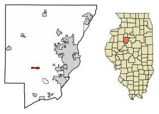
Hanna City is a village in Peoria County, Illinois, United States. The population was 1,225 at the 2010 census. Hanna City is part of the Peoria Metropolitan Statistical Area.

<span class="mw-page-title-main">Eagle Lake, Maine</span> Town in the state of Maine, United States

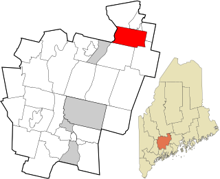
Eagle Lake is a town in Aroostook County, Maine, United States. The population was 772 at the 2020 census. The town was named by a body of troops heading from Bangor to the Aroostook War for the many eagles that they saw around the lake. A total of 49.0% of the population speaks French, reflecting a trend in Northeastern Maine.

<span class="mw-page-title-main">Mapleton, Maine</span> Town in the state of Maine, United States

Mapleton is a town in Aroostook County, Maine, United States. The population was 1,886 at the 2020 census.

<span class="mw-page-title-main">Wallagrass, Maine</span> Town in the state of Maine, United States

Wallagrass is a town in Aroostook County, Maine, United States. The population was 519 at the 2020 census.

<span class="mw-page-title-main">Benton, Maine</span> Town in the state of Maine, United States

Benton is a town in Kennebec County, Maine, United States. It was formed in 1842, as a subdivision of the town of Clinton. The population was 2,715 at the 2020 census. The town was named for Missouri Senator Thomas Hart Benton.

<span class="mw-page-title-main">Vienna, Maine</span> Town in the state of Maine, United States

Vienna is a town in Kennebec County, Maine, United States. The population was 578 at the 2020 census.

<span class="mw-page-title-main">Hartford, Maine</span> Town in the state of Maine, United States

Hartford is a town in Oxford County, Maine, United States. Hartford is included in the Lewiston-Auburn, Maine metropolitan New England City and Town Area. The population was 1,203 at the 2020 census.

Stoneham is a town in Oxford County, Maine, United States. The population was 261 at the 2020 census.

Bradley is a town in Penobscot County, Maine, United States. It is part of the Bangor Metropolitan Statistical Area. The population was 1,532 at the 2020 census. The village of Bradley is in the northwestern corner of the town.

Newburgh is a town in Penobscot County, Maine, United States. The population was 1,595 at the time of the 2020 census.

<span class="mw-page-title-main">Abbot, Maine</span> Town in the state of Maine, United States

Abbot is a town in Piscataquis County, Maine, United States. The population was 650 at the 2020 census. It was named for the treasurer of Bowdoin College, John Abbot.

Canaan is a town in Somerset County, Maine, United States. The population was 2,193 at the 2020 census.

<span class="mw-page-title-main">Manchester, Missouri</span> City in Missouri, United States

Manchester is a city in St. Louis County, Missouri, United States. The population was 18,333 at the 2020 census.

<span class="mw-page-title-main">Page, North Dakota</span> City in North Dakota, United States

Page is a city in Cass County, North Dakota, United States. The population was 190 at the 2020 census. Page was founded in 1882.

<span class="mw-page-title-main">Hanna, Oklahoma</span> Town in Oklahoma, United States

Hanna is a town in southwestern McIntosh County, Oklahoma, United States. Its population was 102 at the time of the 2020 Census. It was named for Hanna Bullett, the daughter of a prominent early resident.

<span class="mw-page-title-main">White Hall, West Virginia</span> Town in West Virginia, United States

White Hall is a town in Marion County, West Virginia, United States. The population was 706 at the 2020 census. Incorporated in 1989, White Hall is adjacent to the county seat, Fairmont, and is part of the Fairmont, West Virginia, Micropolitan Statistical Area. White Hall has many different stores and restaurants.

<span class="mw-page-title-main">Sophia, West Virginia</span> Town in West Virginia, United States

Sophia is a town in Raleigh County, West Virginia, United States. It was incorporated in 1912. The population was 1,124 at the 2020 census.

<span class="mw-page-title-main">Pine Grove, West Virginia</span> Town in West Virginia, United States

Pine Grove is a town in Wetzel County, West Virginia, United States. The population was 363 at the 2020 census. The community was named for a grove of pine trees near the original town site.

<span class="mw-page-title-main">North Hills, West Virginia</span> Town in West Virginia, United States

North Hills is a town in Wood County, West Virginia, United States. It is a suburb of Parkersburg. The population was 837 at the 2020 census. North Hills was incorporated on February 15, 1979.

<span class="mw-page-title-main">East Millinocket, Maine</span> Town in the state of Maine, United States

East Millinocket is a town in Penobscot County, Maine, United States. The population was 1,572 at the 2020 census.

References

  1. "2019 U.S. Gazetteer Files". United States Census Bureau. Retrieved August 7, 2020.
  2. 1 2 3 "U.S. Census website". United States Census Bureau . Retrieved December 14, 2012.
  3. 1 2 "Population and Housing Unit Estimates". United States Census Bureau. May 24, 2020. Retrieved May 27, 2020.
  4. 1 2 "U.S. Census website". United States Census Bureau . Retrieved January 31, 2008.
  5. "US Board on Geographic Names". United States Geological Survey. October 25, 2007. Retrieved January 31, 2008.
  6. Hanna Headlight. "Notice of Work and Upcoming Public Meeting" . Retrieved February 24, 2020.
  7. Allen Best. "Living on the Edge". Archived from the original on July 31, 2012. Retrieved March 8, 2012.
  8. "US Gazetteer files: 2010, 2000, and 1990". United States Census Bureau. February 12, 2011. Retrieved April 23, 2011.
  9. "US Gazetteer files 2010". United States Census Bureau . Retrieved December 14, 2012.
  10. "Census of Population and Housing". Census.gov. Retrieved June 4, 2015.
  11. "Wyoming Public Libraries". PublicLibraries.com. Retrieved June 13, 2019.