Rock River, Wyoming

Last updated

Rock River, Wyoming
Rock River, Wyoming.JPG
Entering Rock River from the West on U.S. Route 30.
Albany County Wyoming Incorporated and Unincorporated areas Rock River Highlighted 5667090.svg
Location of Rock River in Albany County, Wyoming.
Usa edcp location map.svg
Red pog.svg
Rock River, Wyoming
Location in the United States
Coordinates: 41°44′27″N105°58′29″W / 41.74083°N 105.97472°W / 41.74083; -105.97472
Country Flag of the United States.svg United States
State Flag of Wyoming.svg  Wyoming
County Flag of Albany County, Wyoming.gif Albany
Area
[1]
  Total2.33 sq mi (6.03 km2)
  Land2.33 sq mi (6.03 km2)
  Water0.00 sq mi (0.00 km2)
Elevation
6,896 ft (2,102 m)
Population
 (2010) [2]
  Total245
  Estimate 
(2019) [3]
254
  Density109.15/sq mi (42.15/km2)
Time zone UTC-7 (Mountain (MST))
  Summer (DST) UTC-6 (MDT)
ZIP codes
82058, 82083
Area code 307
FIPS code 56-67090 [4]
GNIS feature ID1609147 [5]
Website www.town.rock-river.wy.us/440/Town-of-Rock-River

Rock River is a town in Albany County, Wyoming, United States. As of the 2010 census, the town population was 245.

Contents

Geography

Rock River is located at 41°44′27″N105°58′29″W / 41.74083°N 105.97472°W / 41.74083; -105.97472 (41.740770, –105.974602). [6]

According to the United States Census Bureau, the town has a total area of 2.33 square miles (6.03 km2), all land. [7]

Demographics

Historical population
CensusPop.Note
1910 123
1920 281128.5%
1930 260−7.5%
1940 34934.2%
1950 42421.5%
1960 49717.2%
1970 344−30.8%
1980 41520.6%
1990 190−54.2%
2000 23523.7%
2010 2454.3%
2019 (est.)254 [3] 3.7%
U.S. Decennial Census [8]

2010 census

As of the census [2] of 2010, there were 245 people, 94 households, and 72 families living in the town. The population density was 105.2 inhabitants per square mile (40.6/km2). There were 126 housing units at an average density of 54.1 per square mile (20.9/km2). The racial makeup of the town was 91.4% White, 0.8% Native American, 2.4% from other races, and 5.3% from two or more races. Hispanic or Latino of any race were 9.0% of the population.

There were 94 households, of which 29.8% had children under the age of 18 living with them, 62.8% were married couples living together, 9.6% had a female householder with no husband present, 4.3% had a male householder with no wife present, and 23.4% were non-families. 21.3% of all households were made up of individuals, and 8.5% had someone living alone who was 65 years of age or older. The average household size was 2.61 and the average family size was 2.97.

The median age in the town was 47.5 years. 24.9% of residents were under the age of 18; 3.6% were between the ages of 18 and 24; 18.8% were from 25 to 44; 37% were from 45 to 64; and 15.5% were 65 years of age or older. The gender makeup of the town was 52.2% male and 47.8% female.

2000 census

As of the census [4] of 2000, there were 235 people, 94 households, and 67 families living in the town. The population density was 100.1 people per square mile (38.6/km2). There were 123 housing units at an average density of 52.4 per square mile (20.2/km2). The racial makeup of the town was 96.17% White, 3.40% Native American and 0.43% Asian. Hispanic or Latino of any race were 5.53% of the population.

There were 94 households, out of which 29.8% had children under the age of 18 living with them, 61.7% were married couples living together, 5.3% had a female householder with no husband present, and 27.7% were non-families. 24.5% of all households were made up of individuals, and 12.8% had someone living alone who was 65 years of age or older. The average household size was 2.50 and the average family size was 2.99.

In the town, the population was spread out, with 26.8% under the age of 18, 5.1% from 18 to 24, 26.4% from 25 to 44, 26.0% from 45 to 64, and 15.7% who were 65 years of age or older. The median age was 41 years. For every 100 females, there were 117.6 males. For every 100 females age 18 and over, there were 104.8 males.

The median income for a household in the town was $24,306, and the median income for a family was $31,250. Males had a median income of $25,250 versus $18,125 for females. The per capita income for the town was $11,602. About 14.1% of families and 24.2% of the population were below the poverty line, including 39.5% of those under the age of eighteen and 26.3% of those 65 or over.

Education

Public education in the town of Rock River is provided by Rock River school, which is a part of Albany County School District #1. Grades 9 through 12 are expected to contain about 8 total students per grade through the 2010–2011 school year. [9]

Rock River has a public library, a branch of the Albany County Public Library. [10]

Recreation

The town has one restaurant, Shawna's Roadside Café.

Related Research Articles

<span class="mw-page-title-main">Bennett, Iowa</span> City in Iowa, United States

Bennett is a city in Cedar County, Iowa, United States. The population was 347 at the 2020 census.

<span class="mw-page-title-main">Woodburn, Iowa</span> City in Iowa, United States

Woodburn is a city in Clarke County, Iowa, United States. The population was 146 at the time of the 2020 census.

<span class="mw-page-title-main">Dixon, Iowa</span> City in Iowa, United States

Dixon is a city in Scott County, Iowa, United States. The population was 202 at the time of the 2020 census.

<span class="mw-page-title-main">Caswell, Maine</span> Town in the state of Maine, United States

Caswell is a town in Aroostook County, Maine, United States. The population was 293 at the 2020 census.

<span class="mw-page-title-main">New Canada, Maine</span> Town in the state of Maine, United States

New Canada is a town in Aroostook County, Maine, United States. The population was 310 at the 2020 census.

<span class="mw-page-title-main">Weston, Maine</span> Town in the state of Maine, United States

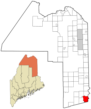
Weston is a town in Aroostook County, Maine, United States. The population was 245 at the 2020 census.

<span class="mw-page-title-main">Benton, Maine</span> Town in the state of Maine, United States

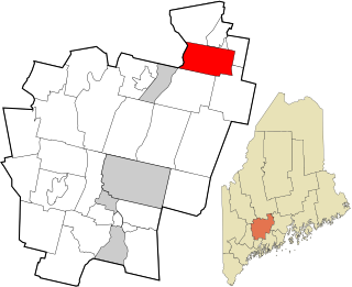
Benton is a town in Kennebec County, Maine, United States. It was formed in 1842, as a subdivision of the town of Clinton. The population was 2,715 at the 2020 census. The town was named for Missouri Senator Thomas Hart Benton.

Lakeville is a town in Penobscot County, Maine, United States. The population was 104 at the 2020 census.

Crawford is a town in Washington County, Maine, United States. The town was named after William H. Crawford, Secretary of the Treasury. The population was 93 at the 2020 census.

<span class="mw-page-title-main">Whitneyville, Maine</span> Town in the state of Maine, United States

Whitneyville is a town in Washington County, Maine, United States. The town was named after Colonel Joseph Whitney, a mill owner. The population was 202 at the 2020 census.

<span class="mw-page-title-main">Marlboro, New York</span> CDP in New York, United States

Marlboro is a hamlet in Ulster County, New York, United States. The population was 3,669 at the 2020 census. Marlboro is in the southeastern part of the town of Marlborough, located in the southeastern corner of the county.

<span class="mw-page-title-main">Kramer, North Dakota</span> City in North Dakota, United States

Kramer is a city in Bottineau County, North Dakota, United States. The population was 24 at the 2020 census. Kramer was founded in 1905.

<span class="mw-page-title-main">Cooper Township, Clearfield County, Pennsylvania</span> Township in Pennsylvania, United States

Cooper Township is a township in Clearfield County, Pennsylvania, United States. The population was 2,593 at the 2020 census.

<span class="mw-page-title-main">Salem, South Carolina</span> Town in South Carolina, United States

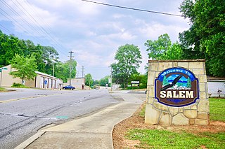
Salem is a U.S. town in Oconee County, South Carolina. The population was 135 at the 2010 United States Census.

<span class="mw-page-title-main">Hazel, South Dakota</span> Town in South Dakota, United States

Hazel is a town in Hamlin County, South Dakota, United States. It is part of the Watertown, South Dakota Micropolitan Statistical Area. The population was 102 at the 2020 census.

<span class="mw-page-title-main">Ward, South Dakota</span> Town in South Dakota, United States

Ward is a town in Moody County, South Dakota, United States. The population was 34 at the 2020 census.

<span class="mw-page-title-main">Agar, South Dakota</span> Town in South Dakota, United States

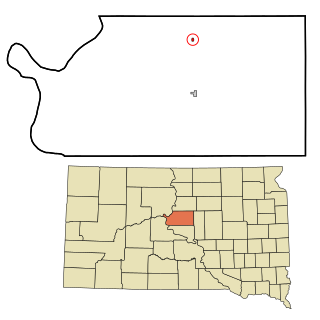
Agar is a small town in Sully County, South Dakota, United States. The population was 76 as of the 2010 census. Agar is a farm/ranch service center.

<span class="mw-page-title-main">Worthington, West Virginia</span> Town in West Virginia, United States

Worthington is a town in Marion County, West Virginia, United States. The population was 158 at the 2010 census. Worthington was incorporated in 1893 and named for Colonel George Worthington, an early settler. U.S. Route 19 passes through the town.

<span class="mw-page-title-main">Dunn, Dane County, Wisconsin</span> Town in Wisconsin, United States

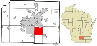
Dunn is a town in Dane County, Wisconsin, United States. The population was 4,880 at the 2020 census.

<span class="mw-page-title-main">Glen Haven, Wisconsin</span> Town in Wisconsin, United States

Glen Haven is a town in Grant County, Wisconsin, United States. According to the 2000 census, the town population was 490. The census-designated place of Glen Haven is located in the town.

References

  1. "2019 U.S. Gazetteer Files". United States Census Bureau. Retrieved 7 August 2020.
  2. 1 2 "U.S. Census website". United States Census Bureau . Retrieved 14 December 2012.
  3. 1 2 "Population and Housing Unit Estimates". United States Census Bureau. 24 May 2020. Retrieved 27 May 2020.
  4. 1 2 "U.S. Census website". United States Census Bureau . Retrieved 31 January 2008.
  5. "US Board on Geographic Names". United States Geological Survey. 25 October 2007. Retrieved 31 January 2008.
  6. "US Gazetteer files: 2010, 2000, and 1990". United States Census Bureau. 12 February 2011. Retrieved 23 April 2011.
  7. "US Gazetteer files 2010". United States Census Bureau. Archived from the original on 25 January 2012. Retrieved 14 December 2012.
  8. "Census of Population and Housing". Census.gov. Retrieved 4 June 2015.
  9. "2009-10 and 2010-11 ADM's for Grades 9-12" (PDF). Wyoming High School Activities Association. Retrieved 4 January 2010.
  10. "Libraries in Wyoming". LibWeb. Retrieved 13 June 2019.