Mount Edith Cavell

Last updated
Mount Edith Cavell
Jasper Park Edith Cavell.jpg
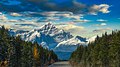
Mount Edith Cavell and the Angel Glacier
Highest point
Elevation 3,363 m (11,033 ft) [1] [2]
Prominence 2,007 m (6,585 ft) [2]
Listing
Coordinates 52°40′06″N118°03′24″W / 52.66833°N 118.05667°W / 52.66833; -118.05667 [2]
Geography
Canada Alberta relief location map - transverse mercator proj.svg
Red triangle with thick white border.svg
Mount Edith Cavell
Alberta, Canada
Canada relief map 2.svg
Red triangle with thick white border.svg
Mount Edith Cavell
Mount Edith Cavell (Canada)
Parent range South Jasper Ranges
Topo map NTS 83D9 Amethyst Lakes
Climbing
First ascent 1915 by A.J. Gilmour and E.W.D. Holway [1]
Easiest route Rock/ice climb, UIAA II

Mount Edith Cavell is a mountain in the Athabasca River and Astoria River valleys of Jasper National Park, and the most prominent peak entirely within Alberta.

Contents

The mountain was named in 1916 for Edith Cavell, a British nurse executed by the Germans during World War I for having helped Allied soldiers escape from occupied Belgium to the Netherlands, in violation of German military law. [1] It was previously known as Mount Fitzhugh. [2]

A close-up view of the north face of Mount Edith Cavell is visible after a short hike to Cavell Meadows. The trailhead is by the parking lot at the end of Mount Edith Cavell Road. The trail to the meadows is 3.8 kilometres (2.4 mi) one way, rising 370 metres (1,214 ft) to 2,135 metres (7,005 ft). The Canadian Rockies Trail Guide describes the trail in detail.

The hanging Angel Glacier is visible from Cavell Meadows, which spills over a 300 metres (984 ft) cliff on the north face.

Access to the Tonquin Valley trails can be found about one kilometre before the end of the Mount Edith Cavell Road. There is a parking area across from the Mount Edith Cavell Hostel. A short walk down the gravel path leads to the north end of Cavell Lake. There is small bridge across the stream that empties the lake. From here there are good views with the lake in the foreground and the Mount Edith Cavell massif in the background.

It is believed that one of the world's largest glacial erratics, called Big Rock, near Okotoks, Alberta, was once part of Mount Edith Cavell. The erratic was formed approximately ten thousand years ago when a large portion of quartzite stone was stripped away from the mountain along with the receding Athabasca River Valley glacier. [3]

Climbing routes

There are several popular climbing routes, including: [1]

The North Face route is included as a classic climb in Steck and Roper's Fifty Classic Climbs of North America . [4]

Notable ascents

In philately

Mount Edith Cavell was featured on a $1 Canadian stamp issued on December 4, 1930. [8]

Climate

Based on the Köppen climate classification, the mountain is in a subarctic climate zone with cold, snowy winters, and mild summers. [9] Temperatures can drop below −20 °C with wind chill factors below −30 °C. Precipitation runoff from the mountain drains into tributaries of the Athabasca River.

Mt. Edith Cavell from Icefields Parkway Canadian Rockies, Mt. Edith Cavell.jpg
Mt. Edith Cavell from Icefields Parkway

See also

Related Research Articles

<span class="mw-page-title-main">Longs Peak</span> Mountain in the Rocky Mountains

Longs Peak is a high and prominent mountain in the northern Front Range of the Rocky Mountains of North America. The 14,259-foot (4346 m) fourteener is located in the Rocky Mountain National Park Wilderness, 9.6 miles (15.5 km) southwest by south of the Town of Estes Park, Colorado, United States. Longs Peak is the northernmost fourteener in the Rocky Mountains of Colorado and the highest point in Boulder County and Rocky Mountain National Park. The mountain was named in honor of explorer Stephen Harriman Long and is featured on the Colorado state quarter.

<span class="mw-page-title-main">Fred Beckey</span> American rock climber and mountaineer

Friedrich Wolfgang Beckey, known as Fred Beckey, was an American rock climber, mountaineer and book author, who in seven decades of climbing achieved hundreds of first ascents of some of the tallest peaks and most important routes throughout Alaska, the Canadian Rockies and the Pacific Northwest. Among the Fifty Classic Climbs of North America, seven were established by Beckey, often climbing with some of the best known climbers of each generation.

<span class="mw-page-title-main">Mount Robson</span> Mountain in British Columbia, Canada

Mount Robson is the most prominent mountain in North America's Rocky Mountain range; it is also the highest point in the Canadian Rockies. The mountain is located entirely within Mount Robson Provincial Park of British Columbia, and is part of the Rainbow Range. Mount Robson is the second highest peak entirely in British Columbia, behind Mount Waddington in the Coast Range. The south face of Mount Robson is clearly visible from the Yellowhead Highway, and is commonly photographed along this route.

<span class="mw-page-title-main">Mount Assiniboine</span> Mountain in Alberta and British Columbia, Canada

Mount Assiniboine, also known as Assiniboine Mountain, is a pyramidal peak mountain on the Great Divide, on the British Columbia/Alberta border in Canada.

<span class="mw-page-title-main">Mount Columbia (Canada)</span> Highest mountain in Alberta, Canada

Mount Columbia is a mountain located in the Winston Churchill Range of the Rocky Mountains. It is the highest point in Alberta, Canada, and is second only to Mount Robson for height and topographical prominence in the Canadian Rockies. It is located on the border between Alberta and British Columbia on the northern edge of the Columbia Icefield. Its highest point, however, lies within Jasper National Park in Alberta.

<span class="mw-page-title-main">Mount Alberta</span> Mountain in Jasper NP, Alberta, Canada

Mount Alberta is a mountain located in the upper Athabasca River Valley of Jasper National Park, Alberta, Canada. J. Norman Collie named the mountain in 1898 after Princess Louise Caroline Alberta. It is the most difficult of the 11,000ers from a climbing point of view.

<span class="mw-page-title-main">Mount Forbes</span> Mountain in Banff NP, Canada

Mount Forbes is the seventh tallest mountain in the Canadian Rockies and the tallest within the boundaries of Banff National Park. It is located in southwestern Alberta, 18 km (11 mi) southwest of the Saskatchewan River Crossing in Banff. The mountain was named by James Hector in 1859 after Edward Forbes, Hector's natural history professor at the University of Edinburgh during the mid-19th century.

<span class="mw-page-title-main">Mount Athabasca</span> Mountain in Jasper National Park, Alberta, Canada

Mount Athabasca is in the Columbia Icefield of Jasper National Park in Canada. The mountain was named in 1898 by J. Norman Collie, who made the first ascent on August 18 of that year. Athabasca is the Cree language name for "where there are reeds", which originally referred to Lake Athabasca. Mount Athabasca is unusual, in that water flows to the Pacific Ocean from the western slope, the Arctic Ocean from the northeastern slope, and to Hudson Bay from the southeastern slope.

<span class="mw-page-title-main">Columbia Icefield</span> Ice field in the Canadian Rockies

The Columbia Icefield is the largest ice field in North America's Rocky Mountains. Located within the Canadian Rocky Mountains astride the Continental Divide along the border of British Columbia and Alberta, Canada, the ice field lies partly in the northwestern tip of Banff National Park and partly in the southern end of Jasper National Park. It is about 325 square kilometres (125 sq mi) in area, 100 to 365 metres in depth and receives up to 7 metres (280 in) of snowfall per year.

<span class="mw-page-title-main">Norman Clyde</span> American mountain climber (1885–1972)

Norman Clyde was a mountaineer, mountain guide, freelance writer, nature photographer, and self-trained naturalist. He is well known for achieving over 130 first ascents, many in California's Sierra Nevada and Montana's Glacier National Park. He also set a speed climbing record on California's Mount Shasta in 1923. The Bancroft Library at the University of California, Berkeley has 1467 articles written by Clyde in its archives.

<span class="mw-page-title-main">Yvon Chouinard</span> American mountain climber (born 1938)

Yvon Chouinard is an American rock climber, environmentalist, philanthropist, and outdoor industry businessman. His company, Patagonia, is known for its commitment to protecting the environment. He was named one of the 100 most influential people in the world by Time magazine in 2023.

<span class="mw-page-title-main">Royal Robbins</span> American rock climber (1935–2017)

Royal Robbins was one of the pioneers of American rock climbing. After learning to climb at Tahquitz Rock, he went on to make first ascents of many big wall routes in Yosemite. As an early proponent of boltless, pitonless clean climbing, he, along with Yvon Chouinard, was instrumental in changing the climbing culture of the late 1960s and early 1970s by encouraging the use and preservation of the natural features of the rock. He went on to become a well-known kayaker.

<span class="mw-page-title-main">Okotoks Erratic</span> Glacial erratic in Alberta, Canada

Okotoks Erratic is a 16,500-tonne (18,200-ton) boulder that lies on the otherwise flat, relatively featureless, surface of the Canadian Prairies in Alberta. It is part of the 930-kilometre-long (580 mi) Foothills Erratics Train of typically angular boulders of distinctive quartzite and pebbly quartzite.

<span class="mw-page-title-main">Mount Lyell (California)</span> Mountain in the American state of California

Mount Lyell is the highest point in Yosemite National Park, at 13,114 feet (3,997 m). It is located at the southeast end of the Cathedral Range, 1+14 miles northwest of Rodgers Peak. The peak as well as nearby Lyell Canyon is named after Charles Lyell, a well-known 19th century geologist. The peak had one of the last remaining glaciers in Yosemite, Lyell Glacier. The Lyell Glacier is currently considered to be a permanent ice field, not a living glacier. Mount Lyell divides the Tuolumne River watershed to the north, the Merced to the west, and the Rush Creek drainage in the Mono Lake Basin to the southeast.

<span class="mw-page-title-main">Crestone Needle</span> Fourteener and twentieth highest mountain in the US state of Colorado (14,203).

Crestone Needle is a high mountain summit of the Crestones in the Sangre de Cristo Range of the Rocky Mountains of North America. The 14,203-foot (4,329 m) fourteener is located 6.9 miles (11.1 km) east-southeast of the Town of Crestone in Saguache County, Colorado, United States. The Crestones are a cluster of high summits in the Sangre de Cristo Range, comprising Crestone Peak, Crestone Needle, Kit Carson Peak, Challenger Point, Humboldt Peak, and Columbia Point. They are usually accessed from common trailheads.

<i>Fifty Classic Climbs of North America</i> 1979 non-fiction book

Fifty Classic Climbs of North America is a climbing guidebook and history written by Steve Roper and Allen Steck. It is considered a classic piece of climbing literature, known to many climbers as simply "The Book", and has served as an inspiration for more recent climbing books, such as Mark Kroese's Fifty Favorite Climbs. Though much of the book's contents are now out of date, it is still recognized as a definitive text which goes beyond the traditional guidebook.

<span class="mw-page-title-main">Robert L. M. Underhill</span> American mountaineer

Robert Lindley Murray Underhill was an American mountaineer best known for introducing modern Alpine style rope and belaying techniques to the U.S. climbing community in the late 1920s and early 1930s.

<span class="mw-page-title-main">Chuck Pratt</span> American rock climber (1939–2000)

Charles Marshall Pratt was an American rock climber known for big wall climbing first ascents in Yosemite Valley. He was also a long-time climbing instructor and mountain guide with Exum Mountain Guides in the Grand Tetons.

<span class="mw-page-title-main">Geraldine Peak</span> Mountain peak in Jasper NP, Alberta, Canada

Geraldine Peak is a 2,930-metre (9,610-foot) mountain summit located in the Athabasca River valley of Jasper National Park, in the Canadian Rockies of Alberta, Canada. The peak is also known as Whirlpool Mountain, and Mount Geraldine. No name has been officially adopted yet. The names derive from its position at the northern end of the long ridge that divides Geraldine Lakes and Geraldine Creek on the southeast side, from the Whirlpool River on the northwest side. The nearest higher peak is Mount Fryatt, 7.0 km (4.3 mi) to the south-southeast. Geraldine Peak can be seen from the Icefields Parkway in the vicinity of Athabasca Falls.

<span class="mw-page-title-main">Hiking, rock climbing, and mountain climbing around Tuolumne Meadows</span>

Hiking, rock climbing, and mountain climbing around Tuolumne Meadows in Yosemite National Park has many options.

References

  1. 1 2 3 4 "Mount Edith-Cavell". cdnrockiesdatabases.ca. Retrieved 2019-09-11.
  2. 1 2 3 4 "Mount Edith Cavell". Bivouac.com. Retrieved 2008-10-11.
  3. "Okotoks Erratic - "The Big Rock"". Government of Alberta. October 25, 2013. Retrieved 2013-12-22.
  4. Roper, Steve; Steck, Allen (1979). Fifty Classic Climbs of North America. San Francisco: Sierra Club Books. ISBN   0-87156-292-8.
  5. Jones, Chris (1976). Climbing in North America . Berkeley, California, USA: University of California Press. pp.  360–361. ISBN   0-520-02976-3.
  6. Jones, p. 341
  7. "Jasper National Park - Edith Cavell, North Face, Chouinard, Becky, Doody 4/9/2009". Cascade Climbers. CascadeClimbers.com. 2009-04-09. Archived from the original on July 8, 2011.
  8. Patrick, Douglas (1964). Canada's Postage Stamps. Toronto: McClelland and Stewart Limited. pp. 60–62.
  9. Peel, M. C.; Finlayson, B. L. & McMahon, T. A. (2007). "Updated world map of the Köppen−Geiger climate classification". Hydrol. Earth Syst. Sci. 11: 1633–1644. ISSN   1027-5606.