Canadian Rockies

Last updated
Canadian Rockies
Rocheuses canadiennes (French)
Snow Dome, Forbes, Lyells, Et al from Mt. Kitchener.jpg
Snow Dome, Mt. Forbes, the Lyells, and others from Mt. Kitchener at the edge of the Columbia Icefield
Highest point
Peak Mount Robson
Elevation 3,954 m (12,972 ft)
Coordinates 53°06′38″N119°09′21″W / 53.11056°N 119.15583°W / 53.11056; -119.15583
Dimensions
Length1,460 km (910 mi) [1]
Width180 km (110 mi) [1]
Area194,000 km2 (75,000 sq mi) [1]
Geography
Canadian Rockies.png
Country Canada
Provinces British Columbia and Alberta
Parent range Pacific Cordillera
Geology
Orogeny Sevier orogeny [2]
Type of rock Sedimentary rock
Ringrose Peak, Lake O'Hara, British Columbia Ringrose.jpg
Ringrose Peak, Lake O'Hara, British Columbia

The Canadian Rockies (French : Rocheuses canadiennes) or Canadian Rocky Mountains, comprising both the Alberta Rockies and the British Columbian Rockies, is the Canadian segment of the North American Rocky Mountains. It is the easternmost part of the Canadian Cordillera, which is the northern segment of the North American Cordillera, the expansive system of interconnected mountain ranges between the Interior Plains and the Pacific Coast that runs northwest–southeast from central Alaska to the Isthmus of Tehuantepec in Mexico.

Contents

Canada officially defines the Rocky Mountains system as the mountain chains east of the Rocky Mountain Trench extending from the Liard River valley in northern British Columbia to the Albuquerque Basin in New Mexico, not including the Mackenzie, Richardson and British Mountains/Brooks Range in Yukon and Alaska (which are all included as the "Arctic Rockies" in the United States' definition of the Rocky Mountains system). [3] The Canadian Rockies, being the northern segment of this chain, is thus defined as comprising the central-eastern section of the North American Cordillera, between the Prairies of Alberta and the Liard Plain of northeastern British Columbia to the east and the Interior Mountains/Plateau and Columbia Mountains to the west. It is divided into the Northern Rockies (which is further subdivided into the Muskwa and Hart Ranges) and Continental Ranges, separated by the McGregor River valley, the McGregor Pass and the Kakwa River valley.

The southern end of the Canadian Rockies extends into the U.S. state of Montana at various sites such as the Wilson Range, Upper Waterton Lake, Boundary Creek, Cameron Lake, Forum Peak, Long Knife Peak, North Fork Flathead River and Frozen Lake. In geographic terms, the boundary is at the Canada–United States border on 49th parallel north, but in geological terms it might be considered to be at Marias Pass in northern Montana.

The Canadian Rockies have numerous high peaks and ranges, such as Mount Robson (3,954 metres; 12,972 feet) and Mount Columbia (3,747 m; 12,293 ft). The Canadian Rockies are composed of shale and limestone. Much of the range is protected by national and provincial parks, several of which collectively comprise a World Heritage Site.

Geography

The Canadian Rockies are the easternmost part of the Canadian Cordillera, the collective name for the mountains of Western Canada. They form part of the American Cordillera, an essentially continuous sequence of mountain ranges that runs all the way from Alaska to the very tip of South America. The Cordillera, in turn, is the eastern part of the Pacific Ring of Fire that runs all the way around the Pacific Ocean.

View of Lake Louise in Alberta View of lake louise and lake mirror.jpg
View of Lake Louise in Alberta

The Canadian Rockies are bounded on the east by the Canadian Prairies, on the west by the Rocky Mountain Trench, and on the north by the Liard River. Contrary to popular misconception, the Rockies do not extend north into Yukon or Alaska, or west into central British Columbia. North of the Liard River, the Mackenzie Mountains, which are a distinct mountain range, form a portion of the border between the Yukon and the Northwest Territories. The mountain ranges to the west of the Rocky Mountain Trench in southern British Columbia are called the Columbia Mountains, and are not considered to be part of the Rockies by Canadian geologists. [1]

Highest peaks

Mount Robson in British Columbia Snow covered mountains in Mount Robson (Unsplash).jpg
Mount Robson in British Columbia

Mount Robson (3,954 metres; 12,972 feet) is the highest peak in the Canadian Rockies, but not the highest in British Columbia, since there are some higher mountains in the Coast Mountains and Saint Elias Mountains. Mount Robson lies on the continental divide near Yellowhead Pass, one of the lowest passes in the Canadian Rockies, and is close to the Yellowhead Highway. Its base is 985 m (3,232 ft) above sea level, with a total vertical relief of 2,969 m (9,741 ft).

Mount Columbia (3,747 m; 12,293 ft) is the second-highest peak in the Canadian Rockies, and is the highest mountain in Alberta.

Snow Dome (3,456 m; 11,339 ft) is one of two hydrological apexes of North America. Water flows off Snow Dome into three different watersheds, into the Pacific Ocean, Arctic Ocean, and Atlantic Ocean via Hudson Bay. [4]

The Canadian Rockies are not the highest mountain ranges in Canada. Both the Saint Elias Mountains (highest point in Canada Mount Logan at 5,959 m; 19,551 ft) and the Coast Mountains (highest point Mount Waddington at 4,016 m; 13,176 ft) have higher summits.

Mountain ranges

The Canadian Rockies are subdivided into numerous mountain ranges, structured in two main groupings, the Continental Ranges, which has three main subdivisions, the Front Range, Park Ranges and Kootenay Ranges, and the Northern Rockies which comprise two main groupings, the Hart Ranges and the Muskwa Ranges. The division-point of the two main groupings is at Monkman Pass northwest of Mount Robson and to the southwest of Mount Ovington.

Rivers

The Canadian Rockies are noted for being the source of several major river systems, and also for the many rivers within the range itself. The Rockies form the divide between the Pacific Ocean drainage on the west and that of Hudson Bay and the Arctic Ocean on the east. Of the range's rivers, only the Peace River penetrates the range. Notable rivers originating in the Canadian Rockies include the Fraser, Columbia, North Saskatchewan, Bow and Athabasca Rivers.

Geology

Sodalite-aegirine-albite pegmatite specimen, Ice River Complex, an intrusion partly in Yoho National Park. Field of view [?]7.1 cm across. Sodalite-aegirine-albite pegmatite, Ice River Complex BC.jpg
Sodalite-aegirine-albite pegmatite specimen, Ice River Complex, an intrusion partly in Yoho National Park. Field of view ≈7.1 cm across.

The Canadian Rockies are quite different in appearance and geology from the American Rockies to the south of them. The Canadian Rockies are composed of layered sedimentary rock such as limestone and shale, whereas the American Rockies are made mostly of metamorphic and igneous rock such as gneiss and granite.

The Canadian Rockies are overall more jagged than the American Rockies, because the Canadian Rockies have been more heavily glaciated, resulting in sharply pointed mountains separated by wide, U-shaped valleys gouged by glaciers, whereas the American Rockies are overall more rounded, with river-carved V-shaped valleys between them. The Canadian Rockies are cooler and wetter, giving them moister soil, bigger rivers, and more glaciers. The tree line is much lower in the Canadian Rockies than in the American Rockies.

Parks

Peyto Lake, Banff National Park Peyto Lake-Banff NP-Canada.jpg
Peyto Lake, Banff National Park
Moraine Lake, Banff National Park Moraine Lake July-2001.JPG
Moraine Lake, Banff National Park

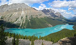
Five national parks are located within the Canadian Rockies, four of which are adjacent and make up the Canadian Rocky Mountain Parks. These four parks are Banff, Jasper, Kootenay and Yoho. The fifth national park, Waterton Lakes, is not adjacent to the others. Waterton Lakes lies farther south, straddling the Canada–US border as the Canadian part of the Waterton-Glacier International Peace Park. The four adjacent parks, combined with three British Columbia provincial parks, were declared a single UNESCO World Heritage Site in 1984 [5] for the unique mountain landscapes found there.

Numerous provincial parks are located in the Canadian Rockies, including Hamber, Mount Assiniboine and Mount Robson parks.

Throughout the Rockies, and especially in the national parks, the Alpine Club of Canada maintains a series of alpine huts for use by mountaineers and adventurers. [6]

Human history

The Rockies and the Canadian Pacific Railway

The Canadian Pacific Railway was founded to provide a link from the province of British Columbia to the eastern provinces. The main difficulty in providing such a link were the Rockies themselves: treacherous mountain passes, fast rivers and sheer drops made for a difficult railway construction process. The following articles describe in detail the political and technical feats involved:

See also

Related Research Articles

<span class="mw-page-title-main">Rocky Mountains</span> Major mountain range in western North America

The Rocky Mountains, also known as the Rockies, are a major mountain range and the largest mountain system in North America. The Rocky Mountains stretch 3,000 miles in straight-line distance from the northernmost part of western Canada, to New Mexico in the southwestern United States. Depending on differing definitions between Canada and the U.S., its northern terminus is located either in northern British Columbia's Terminal Range south of the Liard River and east of the Trench, or in the northeastern foothills of the Brooks Range/British Mountains that face the Beaufort Sea coasts between the Canning River and the Firth River across the Alaska-Yukon border. Its southernmost point is near the Albuquerque area adjacent to the Rio Grande rift and north of the Sandia–Manzano Mountain Range. Being the easternmost portion of the North American Cordillera, the Rockies are distinct from the tectonically younger Cascade Range and Sierra Nevada, which both lie farther to its west.

<span class="mw-page-title-main">Continental Divide of the Americas</span> Principal hydrological divide of North and South America

The Continental Divide of the Americas is the principal, and largely mountainous, hydrological divide of the Americas. The Continental Divide extends from the Bering Strait to the Strait of Magellan, and separates the watersheds that drain into the Pacific Ocean from those river systems that drain into the Atlantic and Arctic Ocean, including those that drain into the Gulf of Mexico, the Caribbean Sea, and Hudson Bay.

<span class="mw-page-title-main">Mount Robson</span> Mountain in British Columbia, Canada

Mount Robson is the most prominent mountain in North America's Rocky Mountain range; it is also the highest point in the Canadian Rockies. The mountain is located entirely within Mount Robson Provincial Park of British Columbia, and is part of the Rainbow Range. Mount Robson is the second highest peak entirely in British Columbia, behind Mount Waddington in the Coast Range. The south face of Mount Robson is clearly visible from the Yellowhead Highway, and is commonly photographed along this route.

<span class="mw-page-title-main">Geography of Alberta</span>

Alberta is one of the thirteen provinces and territories of Canada. Located in Western Canada, the province has an area of 661,190 km2 (255,290 sq mi) and is bounded to the south by the United States state of Montana along 49° north for 298 km (185 mi); to the east at 110° west by the province of Saskatchewan for 1,223 km (760 mi); and at 60° north the Northwest Territories for 644 km (400 mi). The southern half of the province borders British Columbia along the Continental Divide of the Americas on the peaks of the Rocky Mountains, while the northern half borders British Columbia along the 120th meridian west. Along with Saskatchewan it is one of only two landlocked provinces or territories.

<span class="mw-page-title-main">Columbia Icefield</span> Ice field in the Canadian Rockies

The Columbia Icefield is the largest ice field in North America's Rocky Mountains. Located within the Canadian Rocky Mountains astride the Continental Divide along the border of British Columbia and Alberta, Canada, the ice field lies partly in the northwestern tip of Banff National Park and partly in the southern end of Jasper National Park. It is about 325 square kilometres (125 sq mi) in area, 100 to 365 metres in depth and receives up to 7 metres (280 in) of snowfall per year.

<span class="mw-page-title-main">Liard River, British Columbia</span> Place in British Columbia, Canada

Liard River is a small community in northern British Columbia, Canada. It has a population of about 100 people. It is located at Kilometre 799 of the Alaska Highway, near the border of British Columbia and the Yukon Territory.

<span class="mw-page-title-main">Geography of Yukon</span>

Yukon is in the northwestern corner of Canada and is bordered by Alaska and the Northwest Territories. The sparsely populated territory abounds with natural scenery, snowmelt lakes and perennial white-capped mountains, including many of Canada's highest mountains. The territory's climate is Arctic in territory north of Old Crow, subarctic in the region, between Whitehorse and Old Crow, and humid continental climate south of Whitehorse and in areas close to the British Columbia border. Most of the territory is boreal forest with tundra being the main vegetation zone only in the extreme north and at high elevations.

<span class="mw-page-title-main">Geography of British Columbia</span>

British Columbia is the westernmost province of Canada, bordered by the Pacific Ocean. With an area of 944,735 km2 (364,764 sq mi) it is Canada's third-largest province. The province is almost four times the size of the United Kingdom and larger than every United States state except Alaska. It is bounded on the northwest by the U.S. state of Alaska, directly north by Yukon and the Northwest Territories, on the east by Alberta, and on the south by the U.S. states of Washington, Idaho, and Montana. Formerly part of the British Empire, the southern border of British Columbia was established by the 1846 Oregon Treaty. The province is dominated by mountain ranges, among them the Canadian Rockies but dominantly the Coast Mountains, Cassiar Mountains, and the Columbia Mountains. Most of the population is concentrated on the Pacific coast, notably in the area of Vancouver, located on the southwestern tip of the mainland, which is known as the Lower Mainland. It is the most mountainous province of Canada.

The Pacific Cordillera, also known as the Western Cordillera or simply The Cordillera, is a top-level physiographic region of Canada, referring mainly to the extensive cordillera system in Western and Northwestern Canada that constitutes the northern part of the North American Cordillera. The mountain ranges in this region were covered during the Pleistocene by the Cordilleran Ice Sheet, the extent of which gives perspective on the geographic extent of this region. The cordillera extends from the Alaska's Brooks and Alaska Ranges, southeast through most of the Yukon and British Columbia as well as the southwestern fringe of Northwest Territories and Alberta, to stretch its margin beyond the Canada–United States border with five extensive lobes reaching into the mountain valleys of Montana and Washington.

<span class="mw-page-title-main">Rocky Mountain Trench</span> Long valley in British Columbia

The Rocky Mountain Trench, also known as the Valley of a Thousand Peaks or simply the Trench, is a large valley on the western side of the northern part of North America's Rocky Mountains. The Trench is both visually and cartographically a striking physiographic feature extending approximately 1,600 km (1,000 mi) from Flathead Lake, Montana, to the Liard River, just south of the British Columbia–Yukon border near Watson Lake, Yukon. The trench bottom is 3–16 km (1.9–9.9 mi) wide and is 600–900 m (2,000–3,000 ft) above sea level. The general orientation of the Trench is an almost straight 150/330° geographic north vector and has become convenient as a visual guide for aviators heading north or south.

<span class="mw-page-title-main">North American Cordillera</span> North American portion of the American Cordillera mountain chain

The North American Cordillera, sometimes also called the Western Cordillera of North America, the Western Cordillera, or the Pacific Cordillera, is the North American portion of the American Cordillera, the mountain chain system (cordillera) along the western coast of the Americas. The North American Cordillera covers an extensive area of mountain ranges, intermontane basins, and plateaus in Western and Northwestern Canada, Western United States, and Mexico, including much of the territory west of the Great Plains.

<span class="mw-page-title-main">Muskwa River</span> River in British Columbia, Canada

The Muskwa River flows 257 kilometres (160 mi) through northern British Columbia, Canada. It is a major tributary of the Fort Nelson River - part of the Mackenzie River system. The river rises at Fern Lake in the Bedaux Pass in the Northern Rocky Mountains. From there, it flows generally east, then north, and then east again to meet with the Fort Nelson River just east of the town of Fort Nelson. The river drops approximately 1,100 metres (3,600 ft), its course taking it down the Rocky Mountain foothills through sub-alpine and boreal forest to meander across the forest and muskegs of the vast Liard River plains. From mouth to headwater, prominent tributaries include the Prophet River, Tuchodi River, and Gathto Creek. Much of the upper portions of this wilderness river and its watershed are located in the Northern Rocky Mountains Provincial Park, which is part of the larger Muskwa-Kechika Management Area. The region is a popular wilderness recreation destination.

Liard River Hot Springs Provincial Park is a provincial park in British Columbia, Canada. It is home to the second largest natural hot springs in Canada, after Deer River Hot Springs 15 km to the north east. It is a natural river of hot water rather than a spring fed man made pool. The park is part of the larger Muskwa-Kechika Management Area. The community of Liard River, British Columbia is located nearby.

<span class="mw-page-title-main">Great Divide Trail</span> A long-distance hiking trail

The Great Divide Trail (GDT) is a wilderness hiking trail in the Canadian Rockies. The trail closely follows the Great Divide between Alberta and British Columbia, crossing the divide more than 30 times. Its southern terminus is in Waterton Lakes National Park at the Canada–US border and its northern terminus is at Kakwa Lake in Kakwa Provincial Park, north of Jasper National Park. The trail is 1,130 km (700 mi) long and ranges in elevation from 1,055 m (3,461 ft) at Old Fort Point trailhead near Jasper to 2,590 m (8,500 ft) at an unnamed pass above Michele Lakes just south of the White Goat Wilderness Area.

The Northern Rocky Mountains, usually referred to as the Northern Rockies, are a subdivision of the Canadian Rockies comprising the northern half of the Canadian segment of the Rocky Mountains. While their northward limit is easily defined as the Liard River, which is the northward terminus of the whole Rockies, the southward limit is debatable, although the area of Mount Ovington and Monkman Pass is mentioned in some sources, as south from there are the Continental Ranges, which are the main spine of the Rockies forming the boundary between British Columbia and Alberta. Some use the term to mean only the area north of the Peace Arm of the Williston Reservoir, and in reference to Northern Rocky Mountains Provincial Park, while others consider the term to extend all the way south, beyond the limit of the Hart Ranges at Mount Ovington, to include the McBride area, the Sir Alexander Group and Mount Robson.

<span class="mw-page-title-main">Continental divide</span> Drainage divide on a continent

A continental divide is a drainage divide on a continent such that the drainage basin on one side of the divide feeds into one ocean or sea, and the basin on the other side either feeds into a different ocean or sea, or else is endorheic, not connected to the open sea. Every continent on earth except Antarctica has at least one continental drainage divide; islands, even small ones like Killiniq Island on the Labrador Sea in Canada, may also host part of a continental divide or have their own island-spanning divide. The endpoints of a continental divide may be coastlines of gulfs, seas or oceans, the boundary of an endorheic basin, or another continental divide. One case, the Great Basin Divide, is a closed loop around an endorheic basin. The endpoints where a continental divide meets the coast are not always definite since the exact border between adjacent bodies of water is usually not clearly defined. The International Hydrographic Organization's publication Limits of Oceans and Seas defines exact boundaries of oceans, but it is not universally recognized. Where a continental divide meets an endorheic basin, such as the Great Divide Basin of Wyoming, the continental divide splits and encircles the basin. Where two divides intersect, they form a triple divide, or a tripoint, a junction where three watersheds meet.

Sifton Pass, 1012 m (3320 ft), is a mountain pass in the Rocky Mountain Trench in the Northern Interior of British Columbia, Canada, forming the divide between the Fox and Kechika Rivers, and therefore between the drainage basins of the Finlay and Liard Rivers. It also forms a division point between the Muskwa Ranges of the Northern Rockies to its east, and the Cassiar Mountains to its west.

The Prophet River is a river in northern British Columbia, Canada. It is a tributary of the Muskwa River.

References

  1. 1 2 3 4 Gadd, Ben (1995). Handbook of the Canadian Rockies (2nd ed.). Corax Press. ISBN   978-0-9692631-1-1.
  2. "Laramide and Sevier orogenies (PLATE TECTONICS) – g17" (PDF). geowords.com. p. 423. Archived (PDF) from the original on 2020-10-08. Retrieved 2017-08-20.
  3. Madole, Richard F.; Bradley, William C.; Loewenherz, Deborah S.; Ritter, Dale F.; Rutter, Nathaniel W.; Thorn, Colin E. (1987). "Rocky Mountains". In Graf, William L. (ed.). Geomorphic Systems of North America. Decade of North American Geology. Vol. 2 (Centennial Special ed.). Geological Society of America (published 1987-01-01). pp. 211–257. doi:10.1130/DNAG-CENT-v2.211. ISBN   9780813754147 . Retrieved 2021-06-22.
  4. Jennings, Ken. "The Canadian Mountain Peak that Feeds Three Different Oceans". Conde Nast Traveler. Archived from the original on 2020-03-03. Retrieved 3 March 2020.
  5. "Canadian Rocky Mountain Parks". World Heritage List. UNESCO. Archived from the original on 2020-10-08. Retrieved 2010-01-01.
  6. "ACC Huts". Alpine Club of Canada. Retrieved 2022-05-23.

Further reading