Territorial evolution of Canada

Last updated

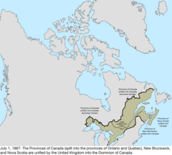
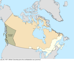
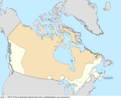
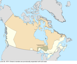
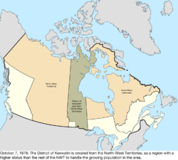
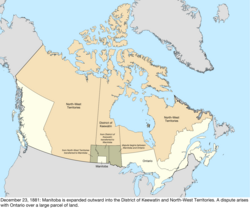
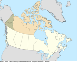
The history of post-confederation Canada began on July 1, 1867, when the British North American colonies of Canada, New Brunswick, and Nova Scotia were united to form a single Dominion within the British Empire. [1] Upon Confederation, the United Province of Canada was immediately split into the provinces of Ontario and Quebec. [2] The colonies of Prince Edward Island and British Columbia joined shortly after, and Canada acquired the vast expanse of the continent controlled by the Hudson's Bay Company, which was eventually divided into new territories and provinces. [3] Canada evolved into a fully sovereign state by 1982. [4]

Contents

Before being part of British North America, the constituents of Canada consisted of the former colonies of Canada and Acadia from within New France which had been ceded to Great Britain in 1763 as part of the Treaty of Paris. [5] French Canadian nationality was maintained as one of the "two founding nations" and legally through the Quebec Act which ensured the maintenance of the Canadian French language, Catholic religion, and French civil law within Canada, a fact which remains true today. [6]

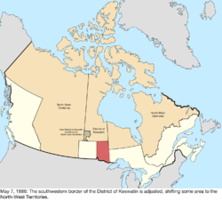
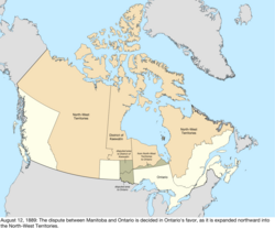
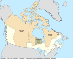
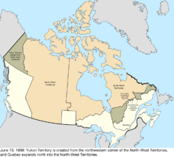
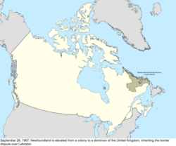
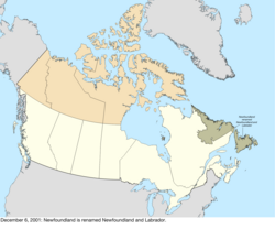
Canada today has ten provinces and three territories; it only lost significant territory in the border dispute over Labrador with the Dominion of Newfoundland, which later joined Canada as the 10th province. [7]

Timeline

DateEventChange
July 1, 1867The Dominion of Canada was formed by the United Kingdom from three provinces of British North America: [8] [lower-alpha 1]

The capital was established at Ottawa.

Canada inherited territorial disputes with the United States over Machias Seal Island and North Rock, which remain disputed up to the present. [14]

Canada change 1867-07-01.png

Disputes:
Canada disputes 1867-07-01 to 1870-07-15.png
July 15, 1870The United Kingdom transferred most of its remaining land in North America to Canada, with the North-Western Territory and Rupert's Land becoming the North-West Territories. [lower-alpha 5] Rupert's Land was transferred to Canada in 1869, [18] but the transfer was only consummated in 1870 when £300,000 was paid to the Hudson's Bay Company. [19]

Due to a vague description and lack of quality surveying, part of the western border with the United States was unclear and disputed. [16] Canada disagreed with the United Kingdom over the extent of Labrador that remained with Newfoundland Colony, citing the historical use of the term "Coasts of Labrador."

A rectangular area of the newly acquired region around the city of Winnipeg was made the province of Manitoba. [lower-alpha 6] [20]

Canada change 1870-07-15.png

Disputes:
Canada dispute change 1870-07-15.png
July 20, 1871The British colony of British Columbia joined Canada as the sixth province. [21] [lower-alpha 7] The province brought along its dispute with the United States over the San Juan Islands, [23] as well as its portion of the Alaska boundary dispute. [16] Canada change 1871-07-20.png

Disputes:
Canada dispute change 1871-07-20.png
October 21, 1872The dispute with the United States over the San Juan Islands was resolved in favour of the United States claim. [23] Canada change 1872-10-21.png

Disputes:
Canada dispute change 1872-10-21.png
July 1, 1873The British colony of Prince Edward Island joined Canada as the seventh province. [24] Canada change 1873-07-01.png
June 26, 1874The borders of Ontario were provisionally expanded north and west. When the Province of Canada was formed, its borders were not entirely clear, and Ontario claimed to eventually reach all the way to the Rocky Mountains and Arctic Ocean. With Canada's acquisition of Rupert's Land, Ontario was interested in clearly defining its borders, especially since some of the new areas it was interested in were rapidly growing. After the federal government asked Ontario to pay for construction in the new disputed area, the province asked for an elaboration on its limits, and its boundary was moved north to 51° north, and west to a line running north from Hunter's Island. [25] Canada change 1874-06-26.png
October 7, 1876The District of Keewatin was created from a central strip of the North-West Territories to provide government for the growing area north of Manitoba and west of Ontario; while the North-West Territories consisted of several districts, Keewatin had an elevated status and many sources note it distinct from the rest of the North-West Territories. [lower-alpha 8] [26] Canada change 1876-10-07.png
September 1, 1880The United Kingdom transferred its Arctic Islands to Canada, where they were made part of the North-West Territories. [27] The archipelago was still being explored and new islands discovered, but the United Kingdom and Canada had claimed the whole archipelago, so new discoveries are not noted unless disputed. Canada change 1880-09-01.png
December 23, 1881 Manitoba was expanded, gaining land from the District of Keewatin and North-West Territories to the west, north, and east. [lower-alpha 9] Since the province's new eastern border was defined as the "western boundary of Ontario", the exact definition of which was still unclear, Ontario disputed a portion of the new region. [29] [28] Canada change 1881-12-23.png
May 7, 1886The southwestern border of the District of Keewatin was adjusted to conform to the boundaries of the provisional districts of the North-West Territories. [lower-alpha 10] [30] Canada change 1886-05-07.png
August 12, 1889The dispute between Manitoba and Ontario ended as Ontario's borders were finalized, extending the province west to the Lake of the Woods and north to the Albany River. [31] Canada change 1889-08-12.png
October 2, 1895The District of Keewatin was expanded to the portion of the North-West Territories north of Ontario. [32] Canada change 1895-10-02.png
December 18, 1897 Southampton Island, Coats Island, Akimiski Island, and other islands were transferred from the North-West Territories to the District of Keewatin, and Boothia Peninsula and Melville Peninsula were transferred from the District of Keewatin to the North-West Territories. [33] Canada change 1897-12-18.png
June 13, 1898 Yukon Territory was created from the District of Yukon in the northwestern part of the North-West Territories to supply a more local government to the explosive growth in population due to the Klondike Gold Rush. [lower-alpha 11] [34] [35] Quebec was enlarged north. [36] [lower-alpha 12] Canada change 1898-06-13.png
May 23, 1901The eastern border of Yukon Territory was adjusted to the Peel River, so that the borders would not cross a watershed, and also to include some more islands, thus exchanging some area with the North-West Territories. [37] Canada change 1901-05-23.png
October 20, 1903The Alaska boundary dispute was resolved, generally in favour of the United States claim. [16] Canada change 1903-10-20.png

Disputes:
Canada dispute change 1903-10-20.png
September 1, 1905The provinces of Alberta (act) and Saskatchewan (act) were created from the North-West Territories. The provinces consisted of the area between British Columbia, Manitoba, the 60th parallel north, and the United States, with Alberta west of the 4th meridian of the Dominion Land Survey and Saskatchewan east of it. The status of the District of Keewatin was lowered back to the other districts of the North-West Territories. [38] [39] [40] [41] [42] Canada change 1905-09-01.png
1906The North-West Territories were renamed the Northwest Territories. [43] [44] Canada change 1906-00-00.png
September 26, 1907The Newfoundland Colony became a dominion of the United Kingdom, inheriting the Labrador boundary dispute.Disputes:
Canada dispute change 1907-09-26.png
April 11, 1908A boundary treaty redefined the maritime border with the United States. [45] Among other changes, this "de-enclaved" Horseshoe Reef in Lake Erie by making the water around it contiguous with the water on the American side of the border. [46] [47] no change to map
August 20, 1910A boundary treaty with the United States addressed a slight uncertainty in the maritime border in Passamaquoddy Bay between New Brunswick and the United States. [48] [49] The border was adjusted to run east of Pope's Folly Island, which previously lay on the border line, and had been the subject of some debate for many years. [50] [51] Canada change 1910-08-20.png
May 15, 1912 Manitoba, Ontario, and Quebec (act) were all expanded northward into land from the Northwest Territories. [43] Quebec was expanded north to fill the mainland, Manitoba extended north to the 60th parallel north, and the new border between Manitoba and Ontario ran northeast from the previous northeastern corner of Manitoba. [52] [53] Canada change 1912-05-15.png
June 1, 1925The maritime boundaries of the Northwest Territories were extended to the North Pole. [43] no change to map
July 17, 1925The border with the United States was adjusted in several places. [54] [55] The only change to a land border redefined how the border between the Lake of the Woods and the Rocky Mountains should be considered; previously, the border followed the curve of the parallel between each border monument, while the treaty changed this to straight lines between each monument. Through this, the United States netted a gain of between 30 and 35 acres of land. Due to the extremely small shift, the lack of specific documentation of where the changes occurred, and the lack of any human impact, this change is not mapped. There was also a change to the border in the Lake of the Woods; due to inaccurate surveying, the previous border intersected itself several times in the lake, creating enclaves of United States water surrounded by Canadian water. The treaty changed the border to use the southernmost intersection as the northwestern point of the Lake of the Woods. Finally, the maritime border in the Bay of Fundy was adjusted, netting Canada roughly 9 acres of water.too small to map
March 11, 1927The Judicial Committee of the British Privy Council decided the Labrador boundary dispute with the Dominion of Newfoundland in favour of Newfoundland. [56] [lower-alpha 13] Quebec has occasionally indicated it does not recognize this border, but has not actively disputed the matter. [56] Canada change 1927-03-11.png

Disputes:
Canada dispute change 1927-03-11.png
November 11, 1930Norway ceded its long-dormant claim to the Sverdrup Islands to Canada, in exchange for British recognition of Norway's sovereignty over Jan Mayen.Disputes:
Canada dispute change 1930-11-11.png
December 11, 1931The Statute of Westminster 1931 confirmed Canada's sovereignty from the United Kingdom on legislative and foreign issues.no change to map
March 31, 1949The Dominion of Newfoundland joined as the tenth province, Newfoundland. [57] [58] Canada change 1949-03-31.png
March 13, 1974The maritime border with Denmark was defined, notably "skipping" Hans Island which lies directly between Ellesmere Island and Greenland, and which was technically on neither side of the border. [59] no change to map
March 1, 1977The United States claimed maritime borders west of the Strait of Juan de Fuca, within the Dixon Entrance, and in the Beaufort Sea that conflicted with claims of Canada. [60] no change to map
April 17, 1982The Constitution Act, 1982, via the Canada Act 1982, made Canada completely independent of the United Kingdom, removing the requirement to involve the British parliament in amending the Canadian constitution.no change to map
October 12, 1984The International Court of Justice decided the maritime border with the United States in the Gulf of Maine. [61] No land changed hands, and the scope of the case did not include the sovereignty of Machias Seal Island. [60] no change to map
April 1, 1999The territory of Nunavut was created from roughly the eastern half of the Northwest Territories. [lower-alpha 14] [62] Canada change 1999-04-01.png
December 6, 2001The province of Newfoundland was renamed Newfoundland and Labrador. [63] Canada change 2001-12-06.png
April 1, 2003Yukon Territory was renamed Yukon, though it remained a territory. [64] Canada change 2003-04-01.png
June 14, 2022An agreement to redefine the maritime border with Denmark was announced, so that it passes through Hans Island rather than skipping over it. [65] no change to map

See also

Notes

  1. The borders of Canada were, from Passamaquoddy Bay: up the St. Croix River to its source; north to the St. John River; up that to the St. Francis River; up that to its source at Lake Pohenegamook; southwesterly to a point on the north branch of the St. John River 10 miles distant from the main branch; then a line from there to where the St. John River crosses 46°25′ north; up the river to its source; then along the height of the land to the source of Halls Stream; down that to 45° north; west along that to the St. Lawrence River; up that to the Great Lakes, passing through Lake Ontario, the Niagara River, Lake Erie, the Detroit River, Lake St. Clair, the St. Clair River, Lake Huron, and Lake Superior, to the Pigeon River; up the height of the land around to a point north of Blanc-Sablon; then south to the Gulf of St. Lawrence. The country included Cape Breton Island and Anticosti Island, but excluded nearby Newfoundland and Prince Edward Island. [9]
  2. The exact border between of Ontario and Quebec was: from where the St. Lawrence River leaves the border with the United States; down the river to a marker on the north bank of Lake Saint Francis at the border of the township of Lancaster (now part of South Glengarry) and the seigneurie of New Longueuil; north 34° west along the boundary to the western angle of New Longueuil; north 25° east along the boundary to the Ottawa River; up that to the height of the land. [10]
  3. The border between New Brunswick and Quebec was, from the outlet of Beau Lake: a line to a point one mile south of the southern point of Long Lake; a line to the southern point of the fiefs of Madawaska and Temiscouata; along that southeast boundary to its southeast angle; north to an east-west line tangent to the height of the land dividing the Rimouski River and the St. John River; east to a north-south line tangent to the height of the land dividing the Rimouski River from the Restigouche River; north to 48° north; east to the Patapédia River; down that to the Restigouche River; and down that to Chaleur Bay. [11] [12]
  4. The border between New Brunswick and Nova Scotia was, from the Bay of Fundy; up the Missiguash River to a post near Black Island; then a complex of lines through and past Black Island, eventually reaching Tidnish Bridge; then down the Tidnish River to Baie Verte. [13]
  5. The new borders of Canada were, from the existing Canada-United States border at the Pigeon River: up the Boundary Waters to the Rainy River and the northwest angle of the Lake of the Woods; south to 49° north; west to the ridge of the Rocky Mountains; north along that to 120° west; north to 60° north; west to the disputed border with the United States described as the "summit of the mountains parallel to the coast"; north along that to 141° west; then north to the Arctic Ocean. The border then followed the coastline, leaving it to include the half of Baffin Bay within the Hudson Bay watershed, then back to the mainland; it then ran down the "Coasts of Labrador", the extent of which were disputed, until it reached the existing Canada-United Kingdom border at Blanc-Sablon. [15] [16] [17]
  6. Manitoba was bounded by 96° west, 99° west, 50°30′ north, and 49° north. [20]
  7. The new borders of Canada were, from the existing Canada-United States border where the ridge of the Rocky Mountains crosses 49° north: west to the Pacific Ocean, through the Strait of Juan de Fuca, around Vancouver Island and Haida Gwaii to the Dixon Entrance; back on land where it ran north along the disputed border with the United States; then up that to where it met the existing border. [22]
  8. The District of Keewatin was defined as the mainland area west of Ontario and Hudson Bay; east of Lake Manitoba, Lake Winnipegosis, and Cedar Lake, and a line north from Cedar Lake; and north of the United States.
  9. Manitoba's new western and northern borders were defined only by township ranges and survey borders, with the southern border being the United States and the eastern border being Ontario. [28]
  10. The new border transferred land from the District of Keewatin west of the Nelson River and Lake Winnipeg, south of a line extending east from the northern border of the District of Saskatchewan, and north of Manitoba, to the North-West Territories. [30]
  11. The borders of Yukon Territory were, from the Arctic Ocean: south along the international boundary to 60° north; east to the Liard River; north along the river to the height of the land; along that, approximately parallel to the Peel River, to 136° west; then north. [34]
  12. The new northern border of Quebec was, starting from James Bay: up the Eastmain River to its source; east to the Hamilton River; then down that to the border with Newfoundland, which was still heavily disputed. [35]
  13. The new Canada-Newfoundland border was, from Blanc-Sablon on the Gulf of St. Lawrence: north to 52° north; west to the height of the land; then following that around to include the watershed of the eastern coast of the Labrador Peninsula. [56]
  14. The Northwest Territories-Nunavut border was complex and described in Schedule I of the Nunavut Act. [62]

Related Research Articles

<span class="mw-page-title-main">Geography of Canada</span>

Canada has a vast geography that occupies much of the continent of North America, sharing a land border with the contiguous United States to the south and the U.S. state of Alaska to the northwest. Canada stretches from the Atlantic Ocean in the east to the Pacific Ocean in the west; to the north lies the Arctic Ocean. Greenland is to the northeast with a shared border on Hans Island. To the southeast Canada shares a maritime boundary with France's overseas collectivity of Saint Pierre and Miquelon, the last vestige of New France. By total area, Canada is the second-largest country in the world, after Russia. By land area alone, however, Canada ranks fourth, the difference being due to it having the world's largest proportion of fresh water lakes. Of Canada's thirteen provinces and territories, only two are landlocked while the other eleven all directly border one of three oceans.

<span class="mw-page-title-main">Provinces and territories of Canada</span> Top-level subdivisions of Canada

Canada has ten provinces and three territories that are sub-national administrative divisions under the jurisdiction of the Canadian Constitution. In the 1867 Canadian Confederation, three provinces of British North America—New Brunswick, Nova Scotia, and the Province of Canada —united to form a federation, becoming a fully independent country over the next century. Over its history, Canada's international borders have changed several times as it has added territories and provinces, making it the world's second-largest country by area.

<span class="mw-page-title-main">British North America</span> Former British imperial territories

British North America comprised the colonial territories of the British Empire in North America from 1783 onwards. English colonisation of North America began in the 16th century in Newfoundland, then further south at Roanoke and Jamestown, Virginia, and more substantially with the founding of the Thirteen Colonies along the Atlantic coast of North America.

The 49th parallel north is a circle of latitude that is 49° north of Earth's equator. It crosses Europe, Asia, the Pacific Ocean, North America, and the Atlantic Ocean.

<span class="mw-page-title-main">Index of Canada-related articles</span>

The following is an alphabetical list of topics related to Canada.

<span class="mw-page-title-main">1903 in Canada</span>

Events from the year 1903 in Canada.

<span class="mw-page-title-main">Canada–United States border</span> International border

The Canada–United States border is the longest international border in the world. The boundary is 8,891 km (5,525 mi) long. The land border has two sections: Canada's border with the contiguous United States to its south, and with the U.S. state of Alaska to its west. The bi-national International Boundary Commission deals with matters relating to marking and maintaining the boundary, and the International Joint Commission deals with issues concerning boundary waters. The agencies responsible for facilitating legal passage through the international boundary are the Canada Border Services Agency (CBSA) and U.S. Customs and Border Protection (CBP).

<span class="mw-page-title-main">Dominion of Newfoundland</span> British dominion from 1907 to 1949

Newfoundland was a British dominion in eastern North America, today the modern Canadian province of Newfoundland and Labrador. It was confirmed by the Balfour Declaration of 1926 and the Statute of Westminster of 1931. It included the island of Newfoundland, and Labrador on the continental mainland. Newfoundland was one of the original dominions within the meaning of the Balfour Declaration, and accordingly enjoyed a constitutional status equivalent to the other dominions of the time.

<i>Quebec Boundaries Extension Act, 1912</i>

The Quebec Boundaries Extension Act, 1912 was passed by the Parliament of Canada on April 1, 1912. It expanded the territory of the Province of Quebec, extending the northern boundary to its present location. The act transferred to the province all of the Northwest Territories' former District of Ungava except offshore islands. This is a vast area bounded by the Eastmain River, the Labrador coast, and Hudson and Ungava Bays. It was first claimed by England in 1670 as Rupert's Land by royal decree, becoming part of Canada after Confederation. The indigenous people of the region are Cree, Montagnais, Naskapi, and Inuit.

<span class="mw-page-title-main">District of Ungava</span>

The District of Ungava was a regional administrative district of Canada's Northwest Territories from 1895 to 1920, although it effectively ceased operation in 1912. It covered the northern portion of what is today Quebec, the interior of Labrador, and the offshore islands to the west and north of Quebec, which are now part of Nunavut.

<span class="mw-page-title-main">Time in Canada</span> Time zones of Canada

Canada is divided into six time zones. Most areas of the country's provinces and territories operate on standard time from the first Sunday in November to the second Sunday in March and daylight saving time the rest of the year.

Transportation in North America is performed through a varied transportation system, whose quality ranges from being on par with a high-quality European motorway to an unpaved gravelled back road that can extend hundreds of miles. There is also an extensive transcontinental freight rail network, but passenger railway ridership is lower than in Europe and Asia.

<span class="mw-page-title-main">Outline of Canada</span> Overview of and topical guide to Canada

The following outline is provided as an overview of and topical guide to Canada:

<span class="mw-page-title-main">Territorial evolution of North America since 1763</span> Timeline of notable events

The 1763 Treaty of Paris ended the major war known by Americans as the French and Indian War and by Canadians as the Seven Years' War / Guerre de Sept Ans, or by French-Canadians, La Guerre de la Conquête. It was signed by Great Britain, France and Spain, with Portugal in agreement. Preferring to keep Guadeloupe, France gave up Canada and all of its claims to territory east of the Mississippi River to Britain. With France out of North America this dramatically changed the European political scene on the continent.

<span class="mw-page-title-main">Former colonies and territories in Canada</span>

A number of states and polities formerly claimed colonies and territories in Canada prior to the evolution of the current provinces and territories under the federal system. North America prior to colonization was occupied by a variety of indigenous groups consisting of band societies typical of the sparsely populated North, to loose confederacies made up of numerous hunting bands from a variety of ethnic groups, to more structured confederacies of sedentary farming villages, to stratified hereditary structures centred on a fishing economy. The colonization of Canada by Europeans began in the 10th century, when Norsemen explored and, ultimately unsuccessfully, attempted to settle areas of the northeastern fringes of North America. Early permanent European settlements in what is now Canada included the late 16th and 17th century French colonies of Acadia and Canada, the English colonies of Newfoundland (island) and Rupert's Land, the Scottish colonies of Nova Scotia and Port Royal.

In Canada, daylight saving time (DST) is observed in nine of the country's ten provinces and two of its three territories—though with exceptions in parts of several provinces and Nunavut.

<span class="mw-page-title-main">Newfoundland and Labrador–Quebec border</span> Border between two Canadian provinces

The border between the province of Newfoundland and Labrador and the province of Quebec is the longest interprovincial border in Canada. It stretches for more than 3,500 kilometres (2,200 mi) on land, and, according to both provincial governments, also contains a maritime part. Starting from the north, the border follows the Laurentian Divide on the Labrador Peninsula for the majority of the border's length, then follows the divide between the Côte-Nord-Gaspé and Newfoundland-Labrador drainage basins as far as Brûlé Lake, after which it goes along the Romaine River downstream to the 52nd parallel, which it follows east to its southeastern terminus at Blanc-Sablon.

<span class="mw-page-title-main">Ashuanipi</span>

The Territory of Ashuanipi was a formerly disputed area and territory of Quebec that was claimed by Quebec and the Dominion of Newfoundland from 1899 and 1927.

References

  1. Patrick James; Mark J. Kasoff (2008). Canadian Studies in the New Millennium. University of Toronto Press. p. 68. ISBN   978-0-8020-9468-1.
  2. David Lublin (2014). Minority Rules: Electoral Systems, Decentralization, and Ethnoregional Party Success. Oxford University Press. pp. 279–280. ISBN   978-0-19-994882-6.
  3. Phillip Alfred Buckner (2008). Canada and the British Empire. Oxford University Press. pp. 58–60. ISBN   978-0-19-927164-1.
  4. Frederick Lee Morton (2002). Law, Politics and the Judicial Process in Canada. University of Calgary Press. pp. 63–66. ISBN   978-1-55238-046-8.
  5. Dale Miquelon (2016). New France 1701-1744: A Supplement to Europe. University of Saskatchewan. pp. 74–76. ISBN   978-0-7710-0338-7.
  6. Michael D. Behiels; Matthew Hayday (2011). Contemporary Quebec: Selected Readings and Commentaries. McGill-Queen's Press. pp. 579–580. ISBN   978-0-7735-3890-0.
  7. Fred M. Shelley (2013). Nation Shapes: The Story Behind the World's Borders. University of Oklahoma. p. 175. ISBN   978-1-61069-106-2.
  8. Constitution Act, 1867  . March 29, 1867 via Wikisource.
  9. "Text of "The Webster–Ashburton Treaty"". The Avalon Project at Yale Law School. Retrieved 2023-11-29.
  10. Scadding, Henry (1876). First Gazetteer of Upper Canada. Copp, Clark & Company. p. 58. Retrieved April 1, 2019.
  11. Boundary Line Between Canada & New Brunswick. 1856.
  12. Ganong, William Francis (1901). A monograph of the evolution of the boundaries of the Province of New Brunswick. p. 402.
  13. Ganong, William Francis (1901). A monograph of the evolution of the boundaries of the Province of New Brunswick. p. 369.
  14. O'Connor, Joe (November 27, 2012). "Puffin Wars: The island paradise at centre of last Canada-U.S. land dispute". National Post . Retrieved April 1, 2019.
  15. Van Zandt, Franklin K. (1976). Boundaries of the United States and the Several States: With Miscellaneous Geographic Information Concerning Areas, Altitudes, and Geographic Centers. Washington, D.C.: U.S. Government Printing Office. pp.  14–15. OCLC   69426475.
  16. 1 2 3 4 Van Zandt, Franklin K. (1976). Boundaries of the United States and the Several States: With Miscellaneous Geographic Information Concerning Areas, Altitudes, and Geographic Centers. Washington, D.C.: U.S. Government Printing Office. p.  32. OCLC   69426475.
  17. "History of Canada". Government of Canada. Retrieved April 1, 2019.
  18. Rupert's Land Act, 1868  . July 31, 1868 via Wikisource.
  19. Rupert's Land and North-Western Territory Order  . June 23, 1870 via Wikisource.
  20. 1 2 Manitoba Act, 1870  . May 12, 1870 via Wikisource.
  21. British Columbia Terms of Union  . May 16, 1871 via Wikisource.
  22. Rickards, Sir George Kettilby (1866). "The British Columbia Act, 1866" . Retrieved April 1, 2019.
  23. 1 2 Van Zandt, Franklin K. (1976). Boundaries of the United States and the Several States: With Miscellaneous Geographic Information Concerning Areas, Altitudes, and Geographic Centers. Washington, D.C.: U.S. Government Printing Office. p.  18. OCLC   69426475.
  24. Prince Edward Island Terms of Union  . June 26, 1873 via Wikisource.
  25. Mills, David (1877). Report on the Boundaries of the Province of Ontario. Toronto: Hunter, Rose & Co. p. 347.
  26. Nicholson, Norman L. (1979). The Boundaries of the Canadian Confederation. Toronto: Macmillan Company of Canada Ltd. p. 113.
  27. Adjacent Territories Order  . July 31, 1880 via Wikisource.
  28. 1 2 Canada (3 August 1881). "Acts of the Parliament of the Dominion of Canada". Brown Chamberlin, Law Printer to the Queen's Most Excellent Majesty via Google Books.
  29. "Land Surveying in Manitoba". Association of Manitoba Land Surveyors. Retrieved November 29, 2023.
  30. 1 2 Canada; Bligh, Harris Harding (3 August 1889). "The Consolidated Orders in Council of Canada: Under the Authority and Direction of His Excellency the Governor-general in Council". B. Chamberlain via Google Books.
  31. Canada (Ontario Boundary) Act 1889  . August 12, 1889 via Wikisource.
  32. Keltie, J. Scott, ed. (1899). The Statesman's Year-Book. London: MacMillan & Co. p. 223.
  33. Extract from Order in Council (Dominion) of the 18th December, 1897, Establishing Provisional Districts in the Unorganized Portions of Canada (PDF). The Labrador Boundary Dispute Documents (Report). Vol. VIII. pp. 4012–4013. Retrieved May 9, 2014. The District of Franklin (situated inside of the grey border on the map herewith) comprising Melville and Boothia Peninsulas, ...
  34. 1 2 Canada (1896). Acts of the Parliament of the Dominion of Canada. p. xlviii. Retrieved March 29, 2019.
  35. 1 2 Yukon Territory Act  . June 13, 1898 via Wikisource.
  36. Quebec Boundary Extension Act, 1898  . June 13, 1898 via Wikisource.
  37. Yukon Territory Act , S.C. 1901, c. 41, s. 14
  38. Alberta Act  . July 20, 1905 via Wikisource.
  39. Saskatchewan Act  . July 20, 1905 via Wikisource.
  40. Thomson, Malcolm M.; Tanner, Richard W. (April 1977). "Canada's Prime Meridian". Journal of the Royal Astronomical Society of Canada . 71. Toronto: 204. Bibcode:1977JRASC..71..204T.
  41. Widdis, Randy (2006). "49th Parallel". The Encyclopedia of Saskatchewan. Canadian Plains Research Center, University of Regina. Retrieved January 6, 2009.
  42. Lewry, Marilyn (2006). "Boundary surveys". The Encyclopedia of Saskatchewan. Canadian Plains Research Center, University of Regina. Retrieved January 6, 2009.
  43. 1 2 3 "History of the Name of the Northwest Territories". Prince of Wales Northern Heritage Centre. Retrieved October 17, 2015.
  44. c.62, RSC 1906
  45. Van Zandt, Franklin K. (1976). Boundaries of the United States and the Several States: With Miscellaneous Geographic Information Concerning Areas, Altitudes, and Geographic Centers. Washington, D.C.: U.S. Government Printing Office. pp.  18–20. OCLC   69426475.
  46. Treaty between the United States of America and the United Kingdom Concerning the Boundary between the United States and the Dominion of Canada from the Atlantic Ocean to the Pacific Ocean, signed April 11, 1908; accessed June 30, 2015
  47. International Boundary between the United States and the Dominion of Canada through the St. Lawrence River and Great Lakes, Sheet No. 12 – Niagara River (Map). Buffalo, New York: International Waterways Commission. August 15, 1913. Retrieved 2016-08-08.
  48. 36 Stat. 2477
  49. Van Zandt, p. 20
  50. "Who Owns Pope's Folly Island?". The New York Times . June 20, 1893. Retrieved May 11, 2015.
  51. Link to a download for the United States Geological Survey map of the Eastport Quadrangle from 1907:
  52. "Manitoba Boundaries Extension Act, 1912". solon.org. Archived from the original on November 11, 2020. Retrieved October 3, 2023.
  53. "Ontario Boundaries Extension Act".
  54. "Treaty Between Canada and the United States of America to define more accurately and to complete the International Boundary between the two Countries" (PDF). February 24, 1925. Archived from the original (PDF) on 2016-08-16. Retrieved May 8, 2015.
  55. Van Zandt, pp. 21–22
  56. 1 2 3 "Henri Dorion debunks the Ten Great Myths about the Labrador boundary". Quebec National Assembly First Session, 34th Legislature. October 17, 1991. Archived from the original on October 26, 2009. Retrieved October 17, 2015.
  57. Newfoundland Act  . March 23, 1949 via Wikisource.
  58. Webb, Jeff A. (March 2008). "The Commission of Government, 1934-1949". Heritage: Newfoundland & Labrador. Memorial University of Newfoundland and the C.R.B. Foundation. Retrieved October 17, 2015.
  59. "Agreement relating to the delimitation of the continental shelf between Greenland and Canada (with annexes); signed December 17, 1973; United Nations Treaty Series 13550" (PDF). Retrieved May 12, 2017.
  60. 1 2 Gray, David H. (Autumn 1997). "Canada's Unresolved Maritime Boundaries" (PDF). IBRU Boundary and Security Bulletin. pp. 61–67. Retrieved 2015-03-21.
  61. Case Concerning Delimitation of the Maritime Boundary in the Gulf of Maine Area (Canada v. United States) Archived 2016-08-17 at the Wayback Machine , accessed June 30, 2015
  62. 1 2 "Nunavut Act". Government of Canada. Retrieved May 12, 2017.
  63. "Constitution Amendment, 2001 (Newfoundland and Labrador)". Government of Canada. December 6, 2001. Archived from the original on August 31, 2014. Retrieved October 17, 2015.
  64. "Yukon Territory name change to Yukon" (PDF). Library and Archives Canada. April 1, 2003. Retrieved July 14, 2009.
  65. Austen, Ian (June 14, 2022). "After 49 years, Canada and Denmark Settle the Ownership of an Arctic Island". The New York Times . Retrieved June 14, 2022.

Further reading