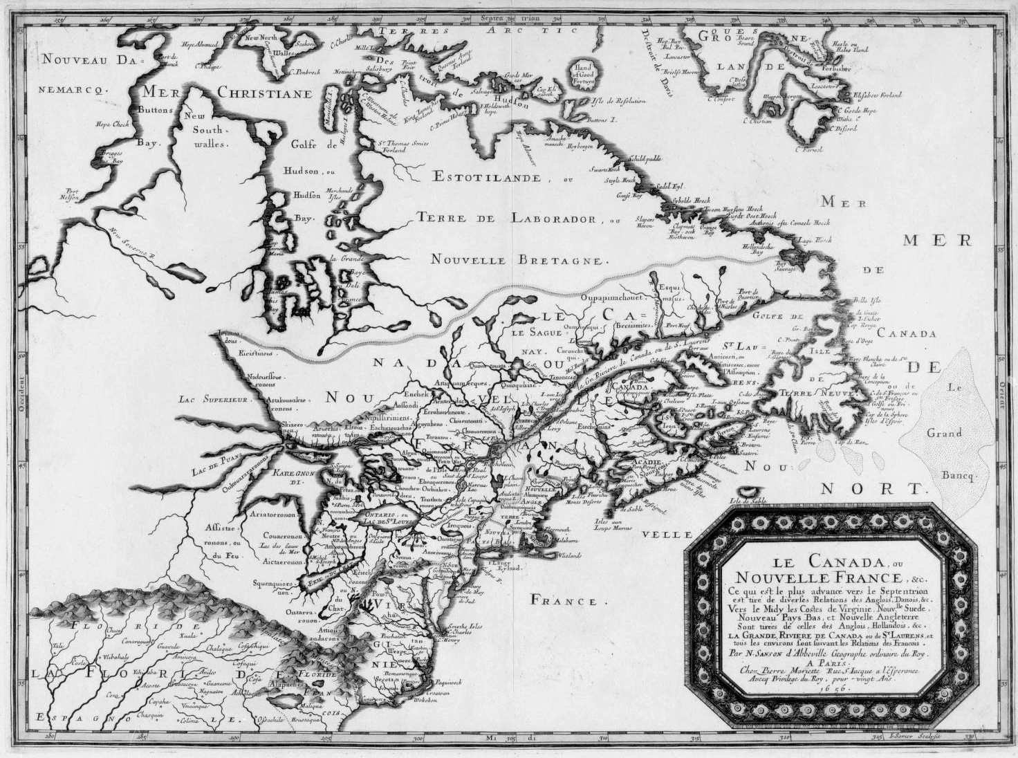
New Britain (Canada)

Last updated

New Britain as a historical term of limited usage referred in its day to the poorly mapped lands of North America north of 17th-century New France. The name applied primarily to today's Nunavik and Labrador interiors, though in the 18th century this had grown to include all of the mainland shores of Hudson Bay and James Bay north of the Canadas. British visitors came to sub-divide the district loosely into the territories of New South Wales, New North Wales and Labrador. The name Labrador predates mention of the other names by more than a century. [1]

Contents

Early exploration

In 1612 Welsh captain Thomas Button wintered on the shores of Hudson Bay, at the mouth of the river he named the Nelson. He dubbed his encampment Port Nelson, and "the whole of the western shore New Wales." [2] Seven years later, in 1619, Danish captain Jens Munk would winter nearby at the mouth of the Churchill River, naming those environs Nova Dania [3] (Latin for "New Denmark").

The region would again be visited twelve years later in 1631 by Captains Thomas James and Luke Foxe. Supposedly Captain Foxe, upon discovering a cross erected by Button at Port Nelson, christened the shore north of the Nelson River as New North Wales, and all the lands south as New South Wales. [4] Another account attributes the event to Captain James, while crediting Foxe with having bestowed upon the region the since-forgotten label of New Yorkshire. [5]

139 years later Captain James Cook would more successfully use the name New South Wales for the Colony of New South Wales which would eventually encompass most of New Holland (Australia). [6] By this time the North American name had begun to fall into obscurity.

Related Research Articles

Robert Bylot was an English explorer who made four voyages to the Arctic. He was uneducated and from a working-class background, but was able to rise to rank of master in the English Royal Navy.

<span class="mw-page-title-main">Hudson Bay</span> Large body of saltwater in northeastern Canada

Hudson Bay, sometimes called Hudson's Bay, is a large body of saltwater in northeastern Canada with a surface area of 1,230,000 km2 (470,000 sq mi). It is located north of Ontario, west of Quebec, northeast of Manitoba and southeast of Nunavut, but politically entirely part of Nunavut. It is an inland marginal sea of the Arctic Ocean. It drains a very large area, about 3,861,400 km2 (1,490,900 sq mi), that includes parts of southeastern Nunavut, Alberta, Saskatchewan, Ontario, Quebec, all of Manitoba, and parts of the U.S. states of North Dakota, South Dakota, Minnesota, and Montana. Hudson Bay's southern arm is called James Bay.

<span class="mw-page-title-main">Southampton Island</span> Island in north Hudson Bay in Nunavut, Canada

Southampton Island is a large island at the entrance to Hudson Bay at Foxe Basin. One of the larger members of the Arctic Archipelago, Southampton Island is part of the Kivalliq Region in Nunavut, Canada. The area of the island is stated as 41,214 km2 (15,913 sq mi) by Statistics Canada. It is the 34th largest island in the world and Canada's ninth largest island. The only settlement on Southampton Island is Coral Harbour, called Salliq in Inuktitut.

<span class="mw-page-title-main">Coats Island</span> Island in Nunavut, Canada

Coats Island lies at the northern end of Hudson Bay in the Kivalliq Region of Nunavut. At 5,498 km2 (2,123 sq mi) in size, it is the 107th largest island in the world, and Canada's 24th largest island.

<span class="mw-page-title-main">Resolution Island (Nunavut)</span> Uninhabited island in Nunavut, Canada

Resolution Island is one of the many uninhabited Canadian Arctic islands in Qikiqtaaluk Region, Nunavut. It is a Baffin Island offshore island located in Davis Strait. It has an area of 1,015 km2 (392 sq mi). The Lower Savage Islands lie between Resolution Island and Baffin Island, while Graves Strait separates Resolution Island from the more northern Edgell Island.

<span class="mw-page-title-main">Foxe Basin</span> Oceanic basin north of Hudson Bay, in Nunavut, Canada

Foxe Basin is a shallow oceanic basin north of Hudson Bay, in Nunavut, Canada, located between Baffin Island and the Melville Peninsula. For most of the year, it is blocked by sea ice and drift ice made up of multiple ice floes.

<span class="mw-page-title-main">Thomas Button</span>

Sir Thomas Button was a Welsh officer of the Royal Navy, notable as an explorer who in 1612–1613 commanded an expedition that unsuccessfully attempted to locate explorer Henry Hudson and to navigate the Northwest Passage.

<span class="mw-page-title-main">Luke Foxe</span> English explorer (1586 – 1635)

Luke Foxe was an English explorer, born in Kingston-upon-Hull, Yorkshire, who searched for the Northwest Passage across North America. In 1631, he sailed much of the western Hudson Bay before concluding no such passage was possible. Foxe Basin, Foxe Channel and Foxe Peninsula were named after him.

<span class="mw-page-title-main">Foxe Peninsula</span>

Foxe Peninsula is a peninsula found at the southern end of Baffin Island in the Qikiqtaaluk Region of Nunavut, Canada. It juts out from the southerly end of the island in a southwestly direction, dividing Foxe Basin and Hudson Strait. Its western extremity is Cape Queen; to the southeast lies the Inuit hamlet of Kinngait. At the western coast is Inuksuk Point, which contains more than 100 inuksuit.

Jens Munk was a Danish-Norwegian navigator and explorer. He entered into the service of King Christian IV of Denmark-Norway and is most noted for his attempts to find the Northwest Passage.

<span class="mw-page-title-main">Port Nelson, Manitoba</span> Town in Manitoba, Canada

Port Nelson was a settlement on Hudson Bay, in Manitoba, Canada, at the mouth of the Nelson River. Its peak population in the early 20th century was about 1,000 people but today it is a ghost town. Immediately to the southsoutheast is the mouth of the Hayes River and the settlement of York Factory. Note that some books use 'Port Nelson' to mean the region around the mouths of the two rivers.

<span class="mw-page-title-main">Thomas James (sea captain)</span> Welsh sea captain and explorer

Captain Thomas James (1593–1635) was a Welsh sea captain, notable as a navigator and explorer, who set out to discover the Northwest Passage, the hoped for ocean route around the top of North America to Asia.

The Ottawa Islands are a group of currently uninhabited islands situated in the eastern edge of Canada's Hudson Bay. The group comprises 24 small islands, located at approximately 60N 80W. The main islands include Booth Island, Bronson Island, Eddy Island, Gilmour Island, J. Gordon Island, Pattee Island, and Perley Island. The highest point is on Gilmour Island, which rises to over 1,800 ft (550 m). Located a short distance off the northwest coast of Quebec's Ungava Peninsula, they, like the other coastal islands in Hudson Bay, were historically part of the Northwest Territories, and became Crown Land upon the creation of Nunavut in 1999. Nunavik Inuit have occupied these islands since time immemorial and gained constitutionally-protected harvest and access rights under the Nunavik Inuit Land Claim Agreement signed in 2007.

<span class="mw-page-title-main">Severn River (Hudson Bay)</span> River in Ontario, Canada

The Severn River is a river in northern Ontario. The northern Ontario river has its headwaters near the western border of the province. From the head of the Black Birch River, the Severn River is 982 km (610 mi) long, tying it with the Albany River for the title of longest river entirely in Ontario. Its drainage basin area is 102,800 km2 (39,700 sq mi), a small portion of which is in Manitoba. Its source is Deer Lake and flows northeasterly into Severn Lake, then by a second section to Hudson Bay where it ends at Fort Severn.

Roes Welcome Sound is a long channel at the northwest end of Hudson Bay in Kivalliq Region, Nunavut, Canada between the mainland on the west and Southampton Island on the east. It opens south into Hudson Bay. Its north end joins Repulse Bay which is connected east through Frozen Strait to Foxe Basin, thereby making Southampton Island an island. Wager Bay is a western branch. It is situated 200 km (120 mi) north of Marble Island. Roes Welcome Sound measures 290 km (180 mi) long, and 24 to 113 km wide.

Dunne Foxe Island is one of the Canadian arctic islands in Nunavut, Canada within western Hudson Bay. The hamlet of Whale Cove is 25 km (16 mi) to the west.

<span class="mw-page-title-main">Timeline of European exploration</span>

This timeline of European exploration lists major geographic discoveries and other firsts credited to or involving Europeans during the Age of Discovery and the following centuries, between the years AD 1418 and 1957.

William Goodlad was a 17th-century English whaler. He was admiral of the Muscovy Company's London whaling fleet for nearly two decades, participating in several of the disputes involving the right to catch whales in Spitsbergen. The Arctic explorer Luke Foxe, in writing about the early voyages to Spitsbergen, said of him: "... but this I leave to Capt. Goodlade [sic], whose great experience this way, and to the E.-ward thereof, is the best able to supply or confute, if he be pleased so to shew himselfe".

<span class="mw-page-title-main">Rebecca Romney</span>

Rebecca Romney was a London based investor.

References

  1. Nelson, Derek; Off the Map: The Curious Histories of Place Names, New York: Kodansha International, 1997, ISBN   1-56836-174-2
  2. Miller, Christy (ed.); The Voyages of Captain Luke Foxe of Hull and Captain Thomas James of Bristol, in Search of a North-West Passage, in 1631–32 , vol. 1, London: Hakluyt Society, 1894, p. 170
  3. Grandjean, Philippe; "Nova Dania: Entries of Jens Munck at Churchill, Manitoba, 1619-1620", American Birds, Spring 1986, p. 42–44
  4. Begg, Alexander; History of the North-West, vol. 1, Toronto: Hunter, Rose & Co., 1894, p. 127
  5. Miller Christy (ed.), The Voyages of Captain Luke Foxe of Hull and Captain Thomas James of Bristol, in Search of a North-West Passage, in 1631–32 , vol. 2, London: Hakluyt Society, 1894, p. 485
  6. McCallum, G. K.; "A Date with Cook: Some observations on the chronology of the Endeavour voyage with an afterword on perpetual calendars", Journal of the Royal Australian Historical Society, vol. 57, pt. 1, March 1971, pp. 1–9

Coordinates: 50°06′39″N75°23′30″W / 50.1107°N 75.3918°W / 50.1107; -75.3918