Hopedale, Newfoundland and Labrador

Last updated

Hopedale
Agvituk
Inuit community
Hopedale pw.jpg
Hopedale
Nickname: 
Place of the Whales
Canada Newfoundland and Labrador location map 2.svg
Red pog.svg
Hopedale
Location of Hopedale in Labrador
Coordinates: 55°27′39″N60°14′00″W / 55.46083°N 60.23333°W / 55.46083; -60.23333 [1]
CountryCanada
Province Newfoundland and Labrador
Region Nunatsiavut
Settled1782
IncorporatedMay 12, 1969
Government
  TypeInuit Community Government
  Mayor (AngajukKâk)Marjorie Flowers
  Federal MP Yvonne Jones (L)
  Provincial MHA Lela Evans (NDP)
   Nunatsiavut Assembly memberTerry Vincent (I) [3]
Area
  Land3.35 km2 (1.29 sq mi)
Population
 (2021)
  Total596
  Density157.9/km2 (409/sq mi)
Time zone UTC-04:00 (AST)
  Summer (DST) UTC-03:00 (ADT)
Area code 709
Climate Dfc

Hopedale (Inuit language: Agvituk) [4] is a town located in the north of Labrador, the mainland portion of the Canadian province of Newfoundland and Labrador. Hopedale is the legislative capital of the Inuit Land Claims Area Nunatsiavut, and where the Nunatsiavut Assembly meets. [5] [6] [7] As of the 2021 census, it has a population of 596.

Contents

History

Hopedale was founded as an Inuit settlement named Agvituk, Inuktitut for "place of the whales". In 1782, Moravian missionaries from Germany arrived in the area to convert the population. They renamed the settlement Hopedale (Hoffental in German) shortly afterwards. The Hopedale Mission is still standing and is thought to be the oldest wooden-frame building in Canada standing east of Quebec. As such, it was named a National Historic Site of Canada. [8] It is currently run by the Agvituk Historical Society as a part of a museum on the history of missionaries in the area.

From 1953 to 1968, a joint Royal Canadian Air Force-United States Air Force's Hopedale Air Station was located on the hills above Hopedale. Civilian personnel lived in the main part of town. Since 1968, the area has remained abandoned other than maintenance of non-military communications towers nearby. [9]

Nunatsiavut

Nunatsiavut Assembly Building Nunatsiavut Assembly Building in Hopedale.jpg
Nunatsiavut Assembly Building

On December 1, 2005, Hopedale became the legislative capital [10] of the autonomous region of Nunatsiavut which is the name chosen by the Labrador Inuit when the Labrador Inuit Land Claims Agreement Act was successfully ratified by the Canadian Government and the Inuit of Labrador. [11] Nain, further north, is the administrative capital. [12] The land claim cedes limited self-rule for the Nunatsiavut government in Northern Labrador and North-Eastern Quebec, granting title and aboriginal rights. [12] The land that comprises the Nunatsiavut government is called the Labrador Inuit Settlement Area, or LISA, which amount to approximately 72,500 km2 (28,000 sq mi). [13] The Inuit of Labrador do not own this land per se, but they do have special rights related to traditional land use as aboriginals. That said, the Labrador Inuit will own 15,000 km2 (5,800 sq mi) within the Settlement Area, officially designated as Labrador Inuit Lands. The Agreement also provides for the establishment of the Torngat Mountains National Park Reserve, consisting of about 9,600 square kilometres (3,700 sq mi) of land within LISA. [13] [14] As legislative capital, Hopedale is the location of the Nunatsiavut Assembly Building. [15]

Demographics

In the 2021 Census of Population conducted by Statistics Canada, Hopedale had a population of 596 living in 193 of its 208 total private dwellings, a change of

The majority of people in Hopedale (79%) speak English as a first language, but a significant minority (21%) speak Inuktitut.

About 83% of the population identify themselves as Inuit, 16% are of mainly European descent, and 1% are of Punjabi origin.

About 87% of the population belongs to a Protestant denomination, about 2% are Roman Catholic, and another 1% are Sikh. About 10% are not affiliated with any religion.

Transportation

There are no roads that connect Hopedale with the rest of Newfoundland and Labrador. [18] [19] [20]

Hopedale Airport, a small public airport, connects the area with small communities in Newfoundland and Labrador and connections beyond made via Goose Bay Airport. [21] The airport was built in the mid 1960s to provide air support to former USAF Hopedale Air Station. Since 1968 the airport is used by civilians.

The airport handles only small turboprop aircraft or helicopters. There is only one service building at the airport. The airport is connected to Hopedale via Airstrip Road.

Between mid-June and mid-November (pending ice conditions), the ferry MV Kamutik W, operated by the Newfoundland and Labrador Government, provides weekly service [22] from Goose Bay along the Atlantic Coast, with stops in Rigolet, Makkovik, Postville, Hopedale, Nain, and Natuashish. [23] Small boats are used to access nearby areas by water.

Local land based transportation in the community is made by private vehicles (cars, trucks, ATV) and snowmobile in winter. There are only a few roads in the community, all gravel:

Services

Policing in Hopedale is provided by the Royal Canadian Mounted Police which has a Hopedale Detachment staffed by four officers. The current detachment was completed in 1994. [24]

There is no hospital located in Hopedale and only basic medical services are provided by Hopedale Community Clinic. The clinic is operated by Newfoundland and Labrador Health Services and is staffed by three nurses/nurse practitioners. Physicians visit periodically, and are also available by video conference. [25] Advanced care requires patients to be flown out of town by air ambulance to the nearest hospital, which is in Happy Valley-Goose Bay.

Hopedale Volunteer Fire Department is a small fire and rescue service with a single pumper stored at the fire hall located next to the RCMP detachment near Water Road.

Canada Post has a post office (19 Harbour Drive B) located in town.

Amos Comenius Memorial School at Nanuk Hill, with grades Kindergarten to Grade 12, [26] is the only school in Hopedale.

DJ's Convenience, Big Land Grocery, Northland Enterprises (with Sylvia's Take Out) are the only stores selling food and other convenience goods in town. [26]

Government

AngajukKâk are equivalent of mayor in Hopedale and are elected every four years. The incumbent is Marjorie Flowers. [27]

Past AngajukKâk:

Local attractions

Hopedale, Moravian mission, Labrador, NL, 1881-85 Hopedale, Moravian mission, Labrador, NL, 1881-85.jpg
Hopedale, Moravian mission, Labrador, NL, 1881-85

There are few local attractions: [29]

Climate

Climate data for Hopedale (AUT)
Coordinates 55°27′N60°13′W / 55.450°N 60.217°W / 55.450; -60.217 (Hopedale) ; elevation: 10 m (33 ft); 1961–1990, extremes 1942–present
MonthJanFebMarAprMayJunJulAugSepOctNovDecYear
Record high °C (°F)5.6
(42.1)
7.2
(45.0)
10.0
(50.0)
11.8
(53.2)
28.3
(82.9)
31.1
(88.0)
33.3
(91.9)
29.4
(84.9)
25.6
(78.1)
20.6
(69.1)
12.9
(55.2)
8.9
(48.0)
33.3
(91.9)
Mean daily maximum °C (°F)−12.3
(9.9)
−11.6
(11.1)
−6.9
(19.6)
−1.1
(30.0)
4.6
(40.3)
10.0
(50.0)
14.4
(57.9)
14.3
(57.7)
10.2
(50.4)
4.5
(40.1)
−0.6
(30.9)
−7.8
(18.0)
1.5
(34.7)
Daily mean °C (°F)−16.4
(2.5)
−16.1
(3.0)
−11.4
(11.5)
−5.2
(22.6)
1.3
(34.3)
6.0
(42.8)
10.3
(50.5)
10.6
(51.1)
7.0
(44.6)
1.9
(35.4)
−3.2
(26.2)
−11.2
(11.8)
−2.2
(28.0)
Mean daily minimum °C (°F)−20.7
(−5.3)
−20.8
(−5.4)
−16.0
(3.2)
−9.4
(15.1)
−2.1
(28.2)
2.0
(35.6)
6.2
(43.2)
6.9
(44.4)
3.8
(38.8)
−0.8
(30.6)
−5.9
(21.4)
−14.8
(5.4)
−6.0
(21.3)
Record low °C (°F)−40.0
(−40.0)
−40.0
(−40.0)
−35.0
(−31.0)
−28.2
(−18.8)
−17.2
(1.0)
−5.6
(21.9)
−1.1
(30.0)
1.1
(34.0)
−5.0
(23.0)
−12.2
(10.0)
−20.6
(−5.1)
−30.0
(−22.0)
−40.0
(−40.0)
Average precipitation mm (inches)75.1
(2.96)
77.7
(3.06)
79.1
(3.11)
56.3
(2.22)
50.7
(2.00)
65.2
(2.57)
86.0
(3.39)
70.2
(2.76)
57.9
(2.28)
68.3
(2.69)
64.8
(2.55)
70.6
(2.78)
821.9
(32.37)
Average rainfall mm (inches)3.5
(0.14)
3.2
(0.13)
3.4
(0.13)
8.3
(0.33)
24.2
(0.95)
58.3
(2.30)
85.4
(3.36)
70.2
(2.76)
55.5
(2.19)
48.2
(1.90)
13.7
(0.54)
4.3
(0.17)
378.2
(14.9)
Average snowfall cm (inches)72.4
(28.5)
75.2
(29.6)
76.5
(30.1)
48.3
(19.0)
25.2
(9.9)
6.6
(2.6)
0.6
(0.2)
0.0
(0.0)
2.4
(0.9)
20.2
(8.0)
51.2
(20.2)
67.2
(26.5)
445.8
(175.5)
Average precipitation days (≥ 0.2 mm)161416141313151513141617176
Average rainy days (≥ 0.2 mm)1.0trace23812151513104285
Average snowy days (≥ 0.2 cm)1613151382trace0trace81316104
Average relative humidity (%)78798080787475747175817977
Source: Environment Canada [31]

See also

Related Research Articles

<span class="mw-page-title-main">Labrador</span> Mainland portion of Newfoundland and Labrador

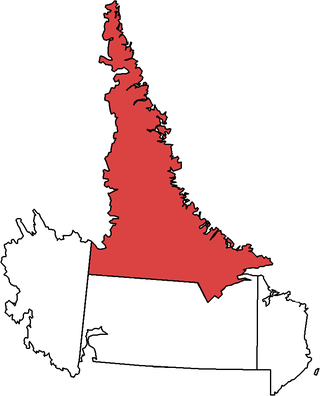
Labrador is a geographic and cultural region within the Canadian province of Newfoundland and Labrador. It is the primarily continental portion of the province and constitutes 71% of the province's area but is home to only 6% of its population. It is separated from the island of Newfoundland by the Strait of Belle Isle. It is the largest and northernmost geographical region in the four Atlantic provinces.

<span class="mw-page-title-main">Nunatsiavut</span> Autonomous area in Newfoundland and Labrador, Canada claimed by the Inuit

Nunatsiavut is an autonomous area claimed by the Inuit in Newfoundland and Labrador, Canada. The settlement area includes territory in Labrador extending to the Quebec border. In 2002, the Labrador Inuit Association submitted a proposal for limited autonomy to the government of Newfoundland and Labrador. The constitution was ratified on December 1, 2005, at which time the Labrador Inuit Association ceased to exist, and the new Government of Nunatsiavut was established, initially being responsible for health, education and cultural affairs. It is also responsible for setting and conducting elections, the first of which was executed in October 2006. An election for the ordinary members of the Nunatsiavut Assembly was held on May 4, 2010. Its incumbent president is Johannes Lampe who assumed office in 2016.

<span class="mw-page-title-main">Lake Melville</span>

Lake Melville is an estuary of Hamilton Inlet on the Labrador coast of the Canadian province of Newfoundland and Labrador. Comprising 3,069 km2 (1,185 sq mi) and stretching 140 km (87 mi) inland to Happy Valley-Goose Bay, it forms part of the largest estuary in the province, primarily draining the Churchill River and Naskaupi River watersheds. Both Lake Melville and Hamilton Inlet are encircled by mountains, with primary settlements at Happy Valley-Goose Bay, North West River, and Sheshatshiu. It is the 46th largest lake globally.

<span class="mw-page-title-main">Nain, Newfoundland and Labrador</span> Inuit community in Newfoundland and Labrador, Canada

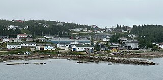
Nain is the northernmost permanent settlement in the Canadian province of Newfoundland and Labrador, within the Nunatsiavut region, located about 370 km (230 mi) by air from Happy Valley-Goose Bay. The town was established as a Moravian mission in 1771 by Jens Haven and other missionaries. As of 2021, the population is 1,204 mostly Inuit and mixed Inuit-European. Nain is the administrative capital of the autonomous region of Nunatsiavut.

<span class="mw-page-title-main">Air Labrador</span>

Labrador Airways Limited, operating as Air Labrador, was a regional airline based at the Goose Bay Airport in Happy Valley-Goose Bay, Newfoundland and Labrador, Canada. It operated scheduled daily passenger and freight services throughout Labrador and Quebec, as well as charter operations with the options of landing in remote and off strip destinations with skis, wheels and floats. The airline's main base was Goose Bay Airport, with a secondary hub at Lourdes-de-Blanc-Sablon Airport, Quebec. Its motto was "The Spirit of Flight".

<span class="mw-page-title-main">Torngat Mountains (electoral district)</span> Provincial electoral district in Newfoundland and Labrador, Canada

Torngat Mountains is a provincial electoral district for the House of Assembly of Newfoundland and Labrador, Canada. As of 2011 there are 2,130 eligible voters living within the district. The district takes its name from the Torngat Mountains.

<span class="mw-page-title-main">Happy Valley-Goose Bay</span> Town in Newfoundland and Labrador, Canada

Happy Valley-Goose Bay is a town in the province of Newfoundland and Labrador, Canada.

<span class="mw-page-title-main">Rigolet</span> Inuit community in Newfoundland and Labrador, Canada

Rigolet is a remote, coastal Labrador community established in 1735 by French-Canadian trader Louis Fornel. The town is the southernmost officially recognized Inuit community in the world. Located on Hamilton Inlet, which is at the entrance to fresh water Lake Melville; Rigolet is on salt water and is accessible to navigation during the winter. Although there is no road access, the community is accessible by snowmobile trail, the Rigolet Airport, or seasonally via a coastal ferry from Happy Valley-Goose Bay.

<span class="mw-page-title-main">Nain Airport</span> Airport in Newfoundland and Labrador, Canada.

Nain Airport is located on the shore of Unity Bay near Nain, Newfoundland and Labrador, Canada.

MV <i>Northern Ranger</i> Ferry

MV Northern Ranger was a Canadian ice-breaking coastal ferry operating in Newfoundland and Labrador. The ship entered service in 1986 for coastal service in Labrador. The vessel provided service between Nain, Newfoundland and Labrador and Happy Valley-Goose Bay, stopping at points between. The ferry was owned and operated by the province of Newfoundland and Labrador. At the end of 2018, the ship was taken out of service and replaced by a newer vessel on the route between Nain and Happy Valley-Goose Bay.

<span class="mw-page-title-main">Torngat Mountains National Park</span> National park in Newfoundland and Labrador, Canada

Torngat Mountains National Park is a Canadian national park located on the Labrador Peninsula in the province of Newfoundland and Labrador. The park encompasses 9,700 km2 of mountainous terrain between Northern Quebec and the Labrador Sea. It is the largest national park in Atlantic Canada and the southernmost national park in the Arctic Cordillera. It partially contains the Torngat Mountains, the highest mountains in mainland Canada east of the Rocky Mountains.

<span class="mw-page-title-main">Postville, Newfoundland and Labrador</span> Town in Newfoundland and Labrador, Canada

Postville is an Inuit town in the north of Labrador, Canada. It had a population of 188 as of 2021. It is located about 40 km (25 mi) inside Kaipokok Bay, 180 km (110 mi) NNE of Happy Valley-Goose Bay. Postville Airport is nearby.

<span class="mw-page-title-main">Makkovik</span> Town in Newfoundland and Labrador, Canada

Makkovik is a town in Labrador in eastern Canada. It had 365 residents in 2021. The main industry is snow crabbing and there is a fishing cooperative.

<span class="mw-page-title-main">North West River</span> Town in Newfoundland and Labrador, Canada

North West River is a small town located in central Labrador. Established in 1743 as a trading post by French Fur Trader Louis Fornel, the community later went on to become a hub for the Hudson's Bay Company and home to a hospital and school serving the needs of coastal Labrador. North West River is the oldest modern settlement in Labrador.

Randy Edmunds is a Canadian politician in Newfoundland and Labrador. He was elected to the Newfoundland and Labrador House of Assembly in the 2011 provincial election. A member of the Liberal Party of Newfoundland and Labrador, he represented the electoral district of Torngat Mountains until 2019.

<span class="mw-page-title-main">Nunatsiavut Assembly Building</span> Building in Newfoundland and Labrador, Canada

The Nunatsiavut Assembly Building in Hopedale, Newfoundland and Labrador is the seat of the autonomous Nunatsiavut Assembly.

<span class="mw-page-title-main">Nunatsiavut Assembly</span> Legislative branch of Nunatsiavut, Canada

The Nunatsiavut Assembly is the legislative branch of the government of Nunatsiavut, Canada.

Lela Margaret Ann Evans is a Canadian politician, who was elected to the Newfoundland and Labrador House of Assembly in the 2019 provincial election. She represents the electoral district of Torngat Mountains as a New Democrat, having previously been elected as a Progressive Conservative. She was re-elected in the 2021 provincial election.

Anthony (Tony) Andersen is a Labrador Inuit politician who serves on the Nunatsiavut Assembly.

References

  1. "Hopedale". Geographical Names Data Base . Natural Resources Canada.
  2. "Hopedale". Geographical Names Data Base . Natural Resources Canada.
  3. Official results of May 3 general election for Ordinary Members to the Nunatsiavut Assembly nunatsiavut.com
  4. Issenman, Betty. Sinews of Survival: The living legacy of Inuit clothing. UBC Press, 1997. pp252-254
  5. "Labrador Inuit land claim passes last hurdle". CBC News. June 24, 2005. Archived from the original on March 21, 2007. Retrieved April 22, 2010.
  6. "Inuit celebrate self-government turnover". CBC News. December 1, 2005. Archived from the original on March 16, 2007. Retrieved April 22, 2010.
  7. Fitzpatrick, Ashley (July 31, 2012). "Nunatsiavut building and rebuilding". NS Business Journal. Archived from the original on March 4, 2016.
  8. Hopedale Mission . Canadian Register of Historic Places . Retrieved 8 July 2012.
  9. "NEWFOUNDLAND AND LABRADOR – Canadian Military History".
  10. Minogue, Sara (June 4, 2004). "Inuit, Métis at odds over Labrador land claim deal". Nunatsiaqonline.ca. Archived from the original on October 12, 2016.
  11. "Labrador's Inuit cheer land agreement". CBC News. January 23, 2005. Archived from the original on January 20, 2007. Retrieved April 22, 2010.
  12. 1 2 "Nunatsiavut Government". nunatsiavut.com. Archived from the original on 2010-02-28. Retrieved 26 December 2018.
  13. 1 2 "Land Claim". nunatsiavut.com. Archived from the original on 2008-06-09. Retrieved 2008-09-23.
  14. "Torngat Mountains National Park Reserve". Archived from the original on 2007-10-22. Retrieved 2008-09-23.
  15. "Nunatsiavut building and rebuilding - Construction & Transportation - Daily Business Buzz". Archived from the original on 2016-03-04. Retrieved 2015-02-09.
  16. "Census Profile, 2016 Census". 8 February 2017. Retrieved Oct 16, 2020.
  17. "Population and dwelling counts: Canada, provinces and territories, census divisions and census subdivisions (municipalities), Newfoundland and Labrador". Statistics Canada. February 9, 2022. Retrieved March 10, 2022.
  18. Moore, Angel (Apr 5, 2020). "Indigenous leaders asking that access to Labrador be sealed off". APTN News. Retrieved Oct 16, 2020.
  19. Mercer, Greg (5 April 2020). "'We are not prepared': Inuit brace for coronavirus to reach remote communities - The Globe and Mail". The Globe and Mail.
  20. "Torngat MHA Calls for New Road to Open Path to North Coast of Labrador". VOCM News. Sep 23, 2020. Retrieved Nov 5, 2020.
  21. Churchill Duke, Laura (20 Sep 2019). "Hopedale woman circulating petition calling for the province to subsidize flights to northern Labrador". Saltwire. Retrieved 23 July 2021.
  22. "Goose Bay - Rigolet - Cartwright - Black Tickle - Ports North To Nain". Provincial Ferry Services. Archived from the original on 2009-08-11. Retrieved 2009-08-30.
  23. "Ferry Service". Tourism Nunatsiavut. Retrieved Nov 4, 2020.
  24. "Hopedale Detachment". Treasury Board of Canada Secretariat. January 1994. Retrieved Nov 4, 2020.
  25. "Hopedale Community Clinic". Labrador-Grenfell Health. 23 April 2018. Retrieved Nov 4, 2020.
  26. 1 2 "Amos Comenius Memorial School". amoscomenius.k12.nf.ca. Retrieved Nov 4, 2020.
  27. "Newly-Elected AngajukKâk For Hopedale". OKâlaKatiget Society. Dec 22, 2015. Retrieved Nov 4, 2020.
  28. "Wayne Piercy". linkedin.com.
  29. "Hopedale". Tourism Nunatsiavut. Retrieved Nov 4, 2020.
  30. "Amaguk Inn". Newfoundland and Labrador Tourism. Retrieved Nov 4, 2020.
  31. "Canadian Climate Normals 1961-1990 Station Data". Environment Canada. 3 February 2022.