Colliers is a town on the Avalon Peninsula in Newfoundland and Labrador, Canada. It is in Division 1 on Conception Bay.

Gambo is a town and designated place in the Canadian province of Newfoundland and Labrador. It is in the northeastern portion of the island of Newfoundland on Freshwater Bay. It is in Division No. 7.
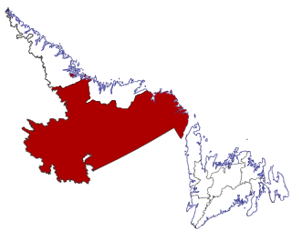
Division No. 8 is a census division on the north coast of the island of Newfoundland in the province of Newfoundland and Labrador, Canada. It has a land area of 9,314.57 km² and had a population of 35,794 at the 2016 census. Its largest communities are the towns of Lewisporte, Springdale, and Twillingate.

Sandy Cove is a town located on the Eastport Peninsula in Newfoundland and Labrador, Canada. It is located on Newman Sound, which is part of Bonavista Bay. It had a population of 120 in the 2021 census.
Census Division No. 10 of Newfoundland and Labrador is composed of the Labrador region of the province, excluding Nunatsiavut. It has a land area of 199,703 km² (77,105.8 sq mi) and at the 2016 census had a population of 24,639, up from 24,111 in 2011. Its two major population centres are the towns of Happy Valley-Goose Bay and Labrador City.

Campbellton is a small lumbering and fishing community located on the island of Newfoundland at Indian Arm, Notre Dame Bay. The community was originally named Indian Arm due to a Beothuk village located on the nearby Indian Arm River. It was renamed to Campbellton in honor of the sawmill manager John Campbell.
Duntara is a town located north west of Catalina, Newfoundland and Labrador. Duntara was an Incorporated Community on October 21, 1961.
Cottlesville is a rural community just outside Summerford on New World Island, Newfoundland and Labrador.
Bellburns is a fishing settlement in the Canadian province of Newfoundland and Labrador. The town holds strong economic ties with the two closest towns Daniels Harbour and Portland Creek.
Bird Cove is a town in the Canadian province of Newfoundland and Labrador.
Bishop's Cove is a town in the Canadian province of Newfoundland and Labrador situated in Spaniard's Bay on the Avalon Peninsula.
Brent's Cove is a town in the Canadian province of Newfoundland and Labrador.
Bryant's Cove is a town in the Canadian province of Newfoundland and Labrador.
Chance Cove is a town in the Canadian province of Newfoundland and Labrador. The town had a population of 213 in the Canada 2021 Census.
Main Brook is a town in the Canadian province of Newfoundland and Labrador. The town had a population of 246 in the Canada 2021 Census.
Middle Arm is a village in the Canadian province of Newfoundland and Labrador. It is located on the northern shore of an inlet of Notre Dame Bay in the north-central part of Newfoundland.

Point au Gaul is a town in the Canadian province of Newfoundland and Labrador, Canada. The town had a population of 67 in the Canada 2021 Census, down from 88 in 2016. Point au Gaul is approximately 76 km southeast of Marystown.
Sally's Cove is a town in the Canadian province of Newfoundland and Labrador. It is located on the west coast of the island of Newfoundland, and is surrounded by Gros Morne National Park. The town had a population of 15 in the Canada 2021 Census.

West St. Modeste is a town in the Canadian province of Newfoundland and Labrador. The town had a population of 102 in the Canada 2021 Census.

L'Anse-au-Loup is a town in the Canadian province of Newfoundland and Labrador. The town had a population of 692 in the Canada 2021 Census, up from 550 in 2011. In the Canada 2006 Census, there were 593 inhabitants. Common Surnames are Barney, Belben, Cabot, Earle, Linstead, Normore, O'Brien, Ryland.
