Baie Verte, Newfoundland and Labrador

Last updated

Baie Verte
Town
Baieverte.JPG
Canada Newfoundland location map.svg
Red pog.svg
Baie Verte
Location of Baie Verte in Newfoundland
Coordinates: 49°54′31″N56°11′41″W / 49.90861°N 56.19472°W / 49.90861; -56.19472 [1] Coordinates: 49°54′31″N56°11′41″W / 49.90861°N 56.19472°W / 49.90861; -56.19472 [2]
CountryCanada
Province Newfoundland and Labrador
Incorporated1968
Government
  MayorShawn Russell
Area
[3]
  Land371.09 km2 (143.28 sq mi)
Population
 (2021) [4]
  Total1,311
  Density3.5/km2 (9/sq mi)
Time zone UTC-03:30 (NST)
  Summer (DST) UTC-02:30 (NDT)
Area code 709
Highways NL Route 410.svg Route 410
NL Route 412.svg Route 412

Baie Verte (2021 Population 1,311 [4] ) is a town located on the north coast of the island portion of the Canadian province of Newfoundland and Labrador on the Baie Verte Peninsula.

Contents

The French named the area for its greenness, "green bay."

Geography

Baie Verte is one of 42 communities that make up the Emerald Zone which is located in the North Central portion of Newfoundland. Baie Verte dates to the late 19th century, but remained a small village until the discovery of asbestos and other ore bodies of copper, lead, zinc and gold in the mid-1950s when the town underwent major expansion. Bowering Brother's steamers called in the area in the 1950s to transport the ore found here. It became a town in 1968.

The major Baie Verte fault line starts here and runs from here to Long Island Sound by way of Vermont. [5]

Climate

Climate data for Baie Verte
Coordinates 49°55′N56°11′W / 49.917°N 56.183°W / 49.917; -56.183 (Baie Verte) ; elevation: 110 m (360 ft); 1961–1990, extremes 1958–1995
MonthJanFebMarAprMayJunJulAugSepOctNovDecYear
Record high °C (°F)11.1
(52.0)
10.6
(51.1)
16.0
(60.8)
20.0
(68.0)
26.7
(80.1)
32.2
(90.0)
34.0
(93.2)
32.2
(90.0)
29.0
(84.2)
23.3
(73.9)
20.0
(68.0)
14.4
(57.9)
34.0
(93.2)
Average high °C (°F)−3.8
(25.2)
−3.7
(25.3)
0.0
(32.0)
3.9
(39.0)
9.6
(49.3)
16.6
(61.9)
21.2
(70.2)
20.0
(68.0)
15.2
(59.4)
9.2
(48.6)
4.0
(39.2)
−1.0
(30.2)
7.6
(45.7)
Daily mean °C (°F)−8.4
(16.9)
−8.9
(16.0)
−4.6
(23.7)
0.1
(32.2)
5.1
(41.2)
11.0
(51.8)
15.6
(60.1)
14.9
(58.8)
10.5
(50.9)
5.1
(41.2)
0.5
(32.9)
−5.0
(23.0)
3.0
(37.4)
Average low °C (°F)−13.1
(8.4)
−14.2
(6.4)
−9.3
(15.3)
−3.8
(25.2)
0.5
(32.9)
5.4
(41.7)
10.1
(50.2)
9.7
(49.5)
5.8
(42.4)
1.0
(33.8)
−2.9
(26.8)
−9.1
(15.6)
−1.7
(28.9)
Record low °C (°F)−28.0
(−18.4)
−33.9
(−29.0)
−30.0
(−22.0)
−20.0
(−4.0)
−13.9
(7.0)
−5.0
(23.0)
0.0
(32.0)
−1.1
(30.0)
−3.9
(25.0)
−11.1
(12.0)
−20.0
(−4.0)
−27.8
(−18.0)
−33.9
(−29.0)
Average precipitation mm (inches)106.7
(4.20)
83.9
(3.30)
82.1
(3.23)
70.2
(2.76)
81.6
(3.21)
91.5
(3.60)
72.3
(2.85)
103.0
(4.06)
93.2
(3.67)
105.2
(4.14)
104.5
(4.11)
106.7
(4.20)
1,100.8
(43.34)
Average rainfall mm (inches)17.7
(0.70)
11.6
(0.46)
26.1
(1.03)
32.3
(1.27)
70.6
(2.78)
90.5
(3.56)
72.3
(2.85)
103.0
(4.06)
93.2
(3.67)
100.4
(3.95)
73.3
(2.89)
30.1
(1.19)
721.1
(28.41)
Average snowfall cm (inches)89.0
(35.0)
74.9
(29.5)
57.0
(22.4)
37.8
(14.9)
10.2
(4.0)
0.9
(0.4)
0
(0)
0
(0)
0
(0)
4.7
(1.9)
30.1
(11.9)
75.5
(29.7)
380.1
(149.7)
Average precipitation days (≥ 0.2 mm)121011101212121315141313147
Average rainy days (≥ 0.2 mm)213511121213151493100
Average snowy days (≥ 0.2 cm)119862trace000trace51051
Source: 1961-1990 Environment and Climate Change Canada [6]

History

The Baie Verte asbestos deposit was discovered in 1955, and Advocate Mines, a division of the giant Johns-Manville Company, began open-pit mining there in 1963. In the 1970s the town was gripped by a strike by asbestos miners over working conditions which lasted for 15 weeks. The Advocate mine shut down in 1981, was reopened in 1982 by Transpacific Asbestos Ltd., but closed permanently in 1990. [7]

The Point Rousse Project is located within the Baie Verte Mining District, on the Point Rousse/Ming's Bight Peninsula. The Project covers three prospective gold trends: the Scrape Trend, the Goldenville Trend and the Deer Cove Trend. These trends have approximately 20 km of cumulative strike length and include three deposits (Pine Cove, Stog’er Tight and Argyle).

Anaconda Mining has been mining at the Pine Cove open pit mine in Baie Verte continuously since 2010, and has produced in excess of 118,028 ounces of gold. [8]

Demographics

In the 2021 Census of Population conducted by Statistics Canada, Baie Verte had a population of 1,311 living in 556 of its 647 total private dwellings, a change of

Notable people

See also

Related Research Articles

Division No. 8 is a census division on the north coast of the island of Newfoundland in the province of Newfoundland and Labrador, Canada. It has a land area of 9,314.57 km² and had a population of 33,940 at the 2016 census. Its largest communities are the towns of Lewisporte, Springdale, and Twillingate.

Labrador City is a town in western Labrador, near the Quebec border. With a population of 7,412 as of 2021, it is the second-largest population centre in Labrador, behind Happy Valley-Goose Bay. Neighbouring Labrador City is Wabush, a smaller town with a population of approximately 1,964 as of 2021. Together, the "twin towns" are known as Labrador West.

Burlington is an incorporated town in Newfoundland and Labrador, Canada. It is a small fishing and lumbering community on Route 413 at the north side of the mouth of Green Bay. Burlington is located approximately 40 km from Baie Verte.

<span class="mw-page-title-main">Schefferville</span> Town in Quebec, Canada

Schefferville is a town in the Canadian province of Quebec. Schefferville is in the heart of the Naskapi and Innu territory in northern Quebec, less than 2 km from the border with Labrador on the north shore of Knob Lake. It is located within the Caniapiscau Regional County Municipality and has an area of 24.76 square kilometres (9.56 sq mi). Schefferville completely surrounds the autonomous Innu community of Matimekosh, and it abuts the small community of Lac-John Reserve. Both of the latter communities are First Nations Innu reserves. Schefferville is also close to the Naskapi reserved land of Kawawachikamach.

<span class="mw-page-title-main">Tilt Cove</span> Town in Newfoundland and Labrador, Canada

Tilt Cove is a town located southeast of Baie Verte on Notre Dame Bay and was founded in 1813. With an official population of 5 at the 2021 census, Tilt Cove is known as "Canada's smallest town." A source of gold, copper, and zinc ores, Tilt Cove was the site of the first mine in Newfoundland. The Tilt Cove mine opened in 1864 and "was soon employing several hundred men at good wages". Postal service was established in 1869.

<span class="mw-page-title-main">Nipper's Harbour</span> Town in Newfoundland and Labrador, Canada

Nipper's Harbour is a town located on the east coast of the Baie Verte Peninsula of Newfoundland in the Canadian province of Newfoundland and Labrador. This incorporated community of 85 people is located on a rocky inlet that combines Nipper's Harbour and Noble's Cove, and where the primary industry is the inshore fishery. The town is approximately 58 km from Baie Verte.

<span class="mw-page-title-main">Wabana, Newfoundland and Labrador</span> Town in Newfoundland and Labrador, Canada

Wabana is a Canadian town and the largest, and only incorporated, community on Bell Island in the province of Newfoundland and Labrador.

The Baie Verte Peninsula is a large peninsula on the north central coast of the island of Newfoundland in the Canadian province of Newfoundland and Labrador.

<span class="mw-page-title-main">Newfoundland and Labrador Route 410</span>

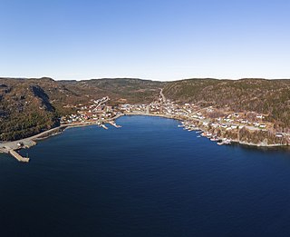
Route 410, also known as Dorset Trail, is an 89.9-kilometre-long (55.9 mi) north-south highway on the northern coast of Newfoundland in the Canadian province of Newfoundland and Labrador. It leads from Sheppardville, at Route 1, to a dead end in Fleur de Lys, Newfoundland and Labrador. Route 410 serves as the primary roadway access on-and-off the Baie Verte Peninsula. Baie Verte is the most populous community along the route.

<span class="mw-page-title-main">Coachman's Cove</span> Town in Newfoundland and Labrador, Canada

Coachman's Cove is a town in the Canadian province of Newfoundland and Labrador. The town had a population of 111 in the Canada 2021 Census.

Fleur de Lys is a town in the Canadian province of Newfoundland and Labrador. The town had a population of 207 in the Canada 2021 Census. Fleur de Lys is located approximately 26 km north of Baie Verte.

Middle Arm is a village in the Canadian province of Newfoundland and Labrador. It is located on the northern shore of an inlet of Notre Dame Bay in the north-central part of Newfoundland.

<span class="mw-page-title-main">Ming's Bight</span> Town in Newfoundland and Labrador, Canada

Ming's Bight is a town in the Canadian province of Newfoundland and Labrador. The town had a population of 298 in 2021 Census, down from 319 in the Canada 2016 Census.

Pacquet is a town in the Canadian province of Newfoundland and Labrador. The town had a population of 164 in 2016, down from 184 in the Canada 2011 Census.

<span class="mw-page-title-main">Seal Cove, White Bay, Newfoundland and Labrador</span> Town in Newfoundland and Labrador, Canada

Seal Cove is a town in the Canadian province of Newfoundland and Labrador, located on White Bay. The town has had a stable population of just over 300 for more than a decade.

Harbour Round is a designated place in the Canadian province of Newfoundland and Labrador. It is east of Baie Verte.

Mainland is a local service district and designated place in the Canadian province of Newfoundland and Labrador. It is on the western shore of the Port au Port Peninsula approximately 50 kilometres (31 mi) from the Stephenville International Airport. Mainland is a coastal community, bordered by both the ocean and forest. The main industry in the community has traditionally been fishing, but currently (2016) a large portion of the inhabitants leave the community seasonally to earn income.

Snook's Arm is a designated place in the Canadian province of Newfoundland and Labrador. The community was entirely resettled in 2018.

Wild Cove is a local service district and designated place in the Canadian province of Newfoundland and Labrador. It is on the Baie Verte Peninsula of the island of Newfoundland.

References

  1. "Baie Verte". Geographical Names Data Base . Natural Resources Canada.
  2. "Baie Verte". Geographical Names Data Base . Natural Resources Canada.
  3. "Census Profile, 2016 Census Baie Verte, Town [Census subdivision], Newfoundland and Labrador". Statistics Canada. 8 February 2017. Retrieved October 21, 2019.
  4. 1 2 3 "Population and dwelling counts: Canada, provinces and territories, census divisions and census subdivisions (municipalities), Newfoundland and Labrador". Statistics Canada. February 9, 2022. Retrieved March 15, 2022.
  5. The Chronicle, September 8, 2008, page 22, "Geologist give talk about Lowell's geologic history"
  6. Environment CanadaNormals 1961–1990. Retrieved 17 February 2022.
  7. "The Baie Verte Asbestos Mines". Newfoundland and Labrador Heritage. Retrieved October 21, 2019.
  8. "Touring Anaconda Mining operation on Baie Verte Peninsula". The Western Star . Saltwire Network. February 15, 2018. Retrieved October 21, 2019.