Wabana, Newfoundland and Labrador

Last updated

Wabana
Town
BellIsland (Wabana) NL PO 2016.jpg
Post office in Wabana
Canada Newfoundland location map.svg
Red pog.svg
Wabana
Location of Wabana in Newfoundland
Coordinates: 47°39′N52°56′W / 47.650°N 52.933°W / 47.650; -52.933
Country Canada
Province Newfoundland and Labrador
Incorporated1950
Government
  MayorGary Gosine
   MHA David Brazil (PC)
Population
 (2021) [1]
  Total1,815
Time zone UTC-3:30 (Newfoundland Time)
  Summer (DST) UTC-2:30 (Newfoundland Daylight)
Area code 709
Highways Ontario M508.svg Car Ferry to Portugal Cove–St. Philip's

Wabana is a Canadian town and the largest, and only incorporated, community on Bell Island in the province of Newfoundland and Labrador. [2] [3]

Contents

Geography

The town is situated on the northeast end of the island and was incorporated in 1950. Bell Island's soil contains red hematite or iron ore and this resource was the main reason for Wabana's development. [4] In addition to Wabana centre, the municipality consists of three more neighbourhoods, namely West Mines to the west, The Green to the north and The Front (or Bell Island Front) to the southeast, near the ferry terminal.

Economy

Wabana came to prominence during the 1890s when the Butler family from Port de Grave staked mining claims on the north side of the island. These were sold to the Nova Scotia Steel Company and later sold to the Dominion Steel Corporation in the early 1900s. The first mine opened in 1896 and the site of the mines was named Wabana by Thomas Cantly, an official with Nova Scotia Steel Co. – the name being Abenaki for "place where the light shines first."

The mines saw Wabana's population swell to 14,000 within a few years, the second largest community in the Dominion of Newfoundland. 101 workers lost their lives over the course of Bell Island's iron ore industry. [5]

A further 65 sailors on merchant ships were lost on two separate attacks by German U-boats in the fall of 1942 which saw 4 cargo ships for carrying iron ore to the steel mill at Sydney, Nova Scotia sunk. [6] [7]

Wabana's population declined following World War II as the underground mines began to face shortfalls in production, being forced to compete with more efficient open pit mines in Labrador and Minnesota. The parent company, Dominion Steel and Coal Corporation (DOSCO), had been in operation since 1930 and was taken over by other conglomerates in the late 1950s. The steel mill and coal mines in Nova Scotia were facing uncertain futures and their shut down was announced in 1965 (although they were subsequently nationalized).

The expected announcement of the shut down of the iron ore mines in Wabana came on April 19, 1966. Following their closure, the mines were left to flood and the population of Wabana has since steadily declined. [8] [9]

Today, the working population mostly commutes to St. John's on a daily basis, while in the summer a tour of one of the decommissioned mines draws tourism to the island. [10] [11] [12] The island is served by the provincial government ferry system, via the MV Flanders and MV Legionnaire. [13] [14] [15] [16] [17]

Wabana houses the island's post office, a supermarket, a gas station, and several convenience stores.

Demographics

Bell Island Lighthouse Bell Island Lighthouse.jpg
Bell Island Lighthouse

In the 2021 Census of Population conducted by Statistics Canada, Wabana had a population of 1,815 living in 951 of its 1,181 total private dwellings, a change of 15.4% from its 2016 population of 2,146. With a land area of 14.49 km2 (5.59 sq mi), it had a population density of

Historical Populations
YearPop.±%
1951 [18] 6,460    
1961 [19] 8,026+24.2%
1966 [20] 7,884−1.8%
1991 [21] 3,608−54.2%
1996 3,136−13.1%
2001 2,679−14.6%
2006 2,418−9.7%
2011 2,346−3.0%
2016 2,146−8.5%
2021 1,815−15.4%

Notable people

Related Research Articles

<span class="mw-page-title-main">Newfoundland and Labrador</span> Province of Canada

Newfoundland and Labrador is the easternmost province of Canada, in the country's Atlantic region. The province comprises the island of Newfoundland and the continental region of Labrador, having a total size of 405,212 square kilometres. In 2023, the population of Newfoundland and Labrador was estimated to be 533,710. The island of Newfoundland is home to around 94 per cent of the province's population, with more than half residing in the Avalon Peninsula. Labrador borders the province of Quebec, and the French overseas collectivity of Saint Pierre and Miquelon lies about 20 km (12 mi) west of the Burin Peninsula.

<span class="mw-page-title-main">Labrador</span> Mainland portion of Newfoundland and Labrador

Labrador is a geographic and cultural region within the Canadian province of Newfoundland and Labrador. It is the primarily continental portion of the province and constitutes 71% of the province's area but is home to only 6% of its population. It is separated from the island of Newfoundland by the Strait of Belle Isle. It is the largest and northernmost geographical region in the four Atlantic provinces.

<span class="mw-page-title-main">Channel-Port aux Basques</span> Town in Newfoundland and Labrador, Canada

Channel-Port aux Basques is a town at the extreme southwestern tip of Newfoundland fronting on the western end of the Cabot Strait. A Marine Atlantic ferry terminal is located in the town which is the primary entry point onto the island of Newfoundland and the western terminus of the Newfoundland and Labrador Route 1 in the province. The town was incorporated in 1945 and its population in the 2021 census was 3,547.

<span class="mw-page-title-main">Bell Island (Newfoundland and Labrador)</span> Canadian island in Conception Bay

Bell Island is an island that is part of Newfoundland and Labrador, Canada's easternmost province. With an area of 34 square kilometres (13 sq mi), it is by far the largest island in Conception Bay, a large bay in the southeast of the island of Newfoundland. The provincial capital of St. John's is less than 20 kilometres (12 mi) to the east.

<span class="mw-page-title-main">Labrador City</span> Town in Newfoundland and Labrador, Canada

Labrador City is a town in western Labrador, near the Quebec border. With a population of 7,412 as of 2021, it is the second-largest population centre in Labrador, behind Happy Valley-Goose Bay. Neighbouring Labrador City is Wabush, a smaller town with a population of approximately 1,964 as of 2021. Together, the "twin towns" are known as Labrador West.

Conception Bay (CB) is a bay on the southeast coast of Newfoundland, Canada.

<span class="mw-page-title-main">Sydney Steel Corporation</span> Canadian steelmaker

Sydney Steel Corporation (SYSCO) was a Crown corporation in the province of Nova Scotia, Canada. It owned and operated a steel mill in Sydney.

<span class="mw-page-title-main">Portugal Cove–St. Philip's</span> Town in Newfoundland and Labrador, Canada

Portugal Cove–St. Philip's is a rural seashore community located on the eastern Avalon Peninsula of Newfoundland in the province of Newfoundland and Labrador, Canada. The town is a bedroom community of the provincial capital of St. John's.

<span class="mw-page-title-main">Rencontre East</span> Town in Newfoundland and Labrador, Canada

Rencontre East is a small, outport community in Newfoundland and Labrador, Canada located north east of Belleoram, and west of Terrenceville in Fortune Bay. The population was 115 in the 2021 census. This small community is not connected to any surrounding areas by road but is accessible by scheduled ferry service from ports in Pool's Cove and Bay L'Argent.

<span class="mw-page-title-main">Dominion Steel and Coal Corporation</span>

The Dominion Steel and Coal Corporation was a Canadian coal mining and steel manufacturing company.

Harry Hibbs was Newfoundland's best-known icon for traditional Newfoundland music.

Hermitage-Sandyville is a small town on the south coast of Newfoundland, Canada, with a population of 404 people in the 2021 Census. The main source of income for the community is provided by the aquaculture industry, the local salmon plant and fishing.

<span class="mw-page-title-main">Pilley's Island</span> Town in Newfoundland and Labrador, Canada

Pilley's Island is a town located on the island of the same name in the Canadian province of Newfoundland and Labrador. It is located in Division No. 8, Newfoundland and Labrador.

TrentonWorks is an industrial manufacturing facility located in the town of Trenton, Nova Scotia, Canada.

Donkin is a Canadian rural village with a population of 532 as of 2021. Located on the picturesque coastline of Nova Scotia's Cape Breton Island, it is a part of the Cape Breton Regional Municipality. The smaller communities of Port Caledonia and Schooner Pond are directly adjacent to the village proper, connected by a single strip of road called the Donkin Highway.

<span class="mw-page-title-main">St. Brendan's, Newfoundland and Labrador</span> Community in Newfoundland and Labrador, Canada

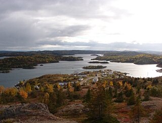
St. Brendan's is a town in the Canadian province of Newfoundland and Labrador, situated in Shoal Cove on Cottel Island in Bonavista Bay. Other settlements on the island include Shalloway Cove, Haywards Cove, and Dock Cove. The town had a population of 125 in the Canada 2021 Census. St. Brendan's is inaccessible by road and is served by a daily ferry service from Burnside.

Lushes Bight–Beaumont–Beaumont North is a town on Long Island in Notre Dame Bay in the Canadian province of Newfoundland and Labrador. The town had a population of 169 at the 2021 Census, down from 275 in the 2006 Census.

Lance Cove, Newfoundland and Labrador is a local service district and designated place in the Canadian province of Newfoundland and Labrador.

When the Second World War broke-out, the Dominion of Newfoundland was a Dominion governed directly from the United Kingdom via the Commission of Government. As Newfoundland was being administered by the Commission of Government, and had no functioning parliament, the British declaration of war on Germany automatically brought Newfoundland into a state of war with Germany on 3 September 1939.

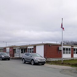
Burnside-St. Chads is a local service district and designated place on the Eastport Peninsula in the Canadian province of Newfoundland and Labrador. A port is located in Burnside through which the MV Grace Sparkes services the isolated island outport of St. Brendan's. Burnside-St. Chads community had a population of 79 in the 2021 census.

References

  1. 1 2 "Population and dwelling counts: Canada, provinces and territories, census divisions and census subdivisions (municipalities), Newfoundland and Labrador". Statistics Canada. February 9, 2022. Retrieved March 15, 2022.
  2. Mooney, Kyle (7 August 2021). "Bell Island's unincorporated communities sidelined in garbage saga". CBC News.
  3. Roberts, Terry (22 August 2017). "Did a Newfoundland town really sell its water system?". CBC News.
  4. Weir, Gail. "Pamphlet" (PDF). research.library.mun.ca. Retrieved 2021-07-27.
  5. "Unseen wonders: Diving pros push to reopen Bell Island mines". CBC News. 2 March 2016.
  6. "Divers visit WWII Bell Island shipwreck site to lay wreath". CBC News. 11 November 2014.
  7. "German U-boat may be at bottom of Labrador river". CBC News. 25 July 2012.
  8. "Iron Ore Mines of Bell Island". www.heritage.nf.ca. Retrieved 2021-07-27.
  9. Mullin, Malone (15 August 2019). "Bell Island's water looks like 'chocolate,' and residents are fed up". CBC News.
  10. "U.S. diver dies while exploring flooded mine". CBC News. 2007-02-04. Retrieved 2012-09-29.
  11. "Air embolism killed Bell Island diver: autopsy". CBC News. 2007-02-07. Retrieved 2012-09-29.
  12. "Bell Island adventurers resume dive in wake of death". CBC News. 2007-02-06. Retrieved 2012-09-29.
  13. Whiffen, Glenn (November 6, 2017). "Sending Legionnaire away not an option, Bell Island protesters say". www.saltwire.com. Retrieved 2021-07-27.
  14. "N.L. ferries made 4,100 trips with no passengers last year". CBC. 2020-05-15. Retrieved 2020-12-17.
  15. Wilhelm, Henrike (29 July 2021). "Bell Island residents reaching 'boiling point' over spotty ferry service". CBC News.
  16. Moore, Mike (5 March 2021). "Town of Wabana says it's taking the N.L. government to court over ferry disruptions". CBC News.
  17. Kelland, Ariana (15 April 2020). "Leave Bell Island only for work and essentials, Wabana mayor says". CBC News.
  18. "Canada Year Book 1955" (PDF).
  19. "Canada Year Book 1967" (PDF).
  20. "Canada Year Book 1968" (PDF).
  21. Statistics Canada 1991 Census Data Table.
  22. "A Fixed Link for Bell island". YouTube .
  23. "Jackman, David Ignatius". Encyclopedia of Newfoundland and Labrador . p. 88.
  24. "Harry Hibbs". Encyclopedia of Music in Canada . Historica Canada. The Canadian Encyclopedia. December 8, 2013. Retrieved August 21, 2019.

47°39′N52°56′W / 47.650°N 52.933°W / 47.650; -52.933