Grates Cove, Newfoundland and Labrador

Last updated

Grates Cove
Grates 027-1-.jpg
Country Flag of Canada (Pantone).svg  Canada
Province Flag of Newfoundland and Labrador.svg  Newfoundland and Labrador
Census division Division 1
Census subdivision Subdivision G
Population
 (2021)
  Total180
Time zone UTC-3:30 (Newfoundland Time)
  Summer (DST) UTC-2:30 (Newfoundland Daylight)
Area code 709
Highways Grates Cove Road to NL Route 70.svg Route 70

Grates Cove is a local service district and designated place in the Canadian province of Newfoundland and Labrador. It is the most northerly community on the Avalon Peninsula, located on the tip of the Bay de Verde Peninsula on the island of Newfoundland. Called "the Grates" by John Guy as early as 1612, the origin of the name is unknown.

Contents

History

Grates Cove was first settled in 1790 by four families from Lower Island Cove and one family from Old Perlican. It is believed that Grates Cove was visited by seasonal fisherman before this and some have expressed the belief that it was visited as early as 1497 by John Cabot. [1] This speculation has been fueled by the presence of a large rock high above the water on a cliff face located in Grates Cove. As Harold Horwood states, "some of those who formerly examined it, including a curator of the Newfoundland Museum, professed to be able to read the names IO CABOTO, SANCIUS and SAINMALIA quite plainly." [1]

Timeline

The shipwreck of The Mollie

The Mollie was a coasting schooner posted out of Carmanville, Newfoundland that was lost near Grates Cove on the evening of December 20, 1944. All people on board were lost. The Mollie's Captain was Ross Chaulk, who was 26 years old and unmarried. Lost with him were James Ellsworth, age 25, John Goodyear, age 61 also his two sons Reginald Goodyear, age 32 and Charles Goodyear, age 26, both of them were also unmarried. The last crew member was Otto Hicks of Musgrave Harbour, who was a widower with one child. The cook, Charles Goodyear just 2 years earlier survived another near-miss shipwreck on the schooner L.C. Norman when it ran into the tip of Cape Bonavista. 13 crews of men from Grates Cove made trips to recover the bodies of the crew of The Mollie.

Geography

Grates Cove is in Newfoundland within Subdivision G of Division No. 1. [2]

Demographics

As a designated place in the 2016 Census of Population conducted by Statistics Canada, Grates Cove recorded a population of 127 living in 59 of its 95 total private dwellings, a change of

Government

Grates Cove is a local service district (LSD) [4] that is governed by a committee responsible for the provision of certain services to the community. [5] The chair of the LSD committee is David Stanford. [4]

Attractions

National historic site

The "Walled Landscape of Grates Cove" was designated a National Historic Site of Canada in 1995. The designated site comprises 60.7 hectares (150 acres) of grassy landscape containing small gardens demarcated by stone walls. The area represents a rare surviving example of a communal system of land and community organization unique to Newfoundland. [6]

See also

Related Research Articles

<span class="mw-page-title-main">Division No. 1, Newfoundland and Labrador</span> Census division in Newfoundland and Labrador, Canada

Division 1, Newfoundland and Labrador is a census division covering the entire Avalon Peninsula including the Isthmus of Avalon of the Canadian province of Newfoundland and Labrador. Like all census divisions in Newfoundland and Labrador, but unlike the census divisions of some other provinces, the division exists only as a statistical division for census data, and is not a political entity.

<span class="mw-page-title-main">Carbonear-Trinity-Bay de Verde</span> Provincial electoral district in Newfoundland and Labrador, Canada

Carbonear-Trinity-Bay de Verde is a provincial electoral district of the House of Assembly of Newfoundland and Labrador, Canada. The district covers the eastern edge of Trinity Bay and the tip of Conception Bay. As of 2011, there are 6,968 eligible voters living within the district.

<span class="mw-page-title-main">Caplin Cove</span> Community in Newfoundland and Labrador, Canada

Caplin Cove is a small community on the north shore of Conception Bay, Newfoundland and Labrador, Canada. It is surrounded on the north by Low Point near the end of the Bay de Verde Peninsula, and on the south by Lower Island Cove. Caplin Cove was probably named for the large body of capelin in its waters.

New Chelsea-New Melbourne-Brownsdale-Sibley's Cove-Lead Cove is a local service district and designated place in the Canadian province of Newfoundland and Labrador.

The Bay de Verde Peninsula is the largest peninsula that makes up part of the Avalon Peninsula, of the province of Newfoundland and Labrador, Canada. The peninsula separates both Trinity and Conception Bay.

Piccadilly Slant-Abraham's Cove is a local service district and designated place in the Canadian province of Newfoundland and Labrador. It is located on the island of Newfoundland, along St. George's Bay, on the Port au Port Peninsula. The DPL consists of the fishing villages of Abraham's Cove and Piccadilly.

Aspen Cove is a small fishing community in the province of Newfoundland and Labrador, Canada. Formerly called Aspey or Apsey Cove, Aspen Cove was named for the presence of aspen trees in the area. It first appears in the 1857 Census as Apsey Cove with a population of thirteen, all dependent on the salmon fishery. By the 1870s more families moved to Aspen Cove for the cod and lobster fisheries. In the 1921 census the population had reached 104 and the economy had changed from salmon, fur, and agriculture to cod, lobster, and lumbering.

<span class="mw-page-title-main">Northern Bay, Newfoundland and Labrador</span>

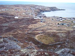
Northern Bay is a small community on the northern tip of Conception Bay on the Bay de Verde Peninsula, Subdivision 1G, Newfoundland and Labrador, Canada.

Bay de Verde is an incorporated town in Conception Bay on the northern tip of the Bay de Verde Peninsula of Newfoundland and Labrador, Canada. The first recorded inhabitants at Bay de Verde arrived in 1662. Bay de Verde became an incorporated town in 1950.

<span class="mw-page-title-main">Frederickton, Newfoundland and Labrador</span>

Frederickton is a designated place in the Canadian province of Newfoundland and Labrador.

Noggin Cove is a local service district and designated place in the Canadian province of Newfoundland and Labrador. It is west of Carmanville on the south side of Hamilton Sound. It is said to be named after Noggin Island, about 5 km off its eastern point.

Ladle Cove is a designated place in the Canadian province of Newfoundland and Labrador. It is along the Straight Shore on the island of Newfoundland.

<span class="mw-page-title-main">Coachman's Cove</span> Town in Newfoundland and Labrador, Canada

Coachman's Cove is a town in the Canadian province of Newfoundland and Labrador. The town had a population of 111 in the Canada 2021 Census.

<span class="mw-page-title-main">Flatrock, Newfoundland and Labrador</span> Town in Newfoundland and Labrador, Canada

Flatrock is a town in Newfoundland and Labrador. The town had a population of 1,722 in the Canada 2021 Census.

<span class="mw-page-title-main">St. Bernard's-Jacques Fontaine</span> Town in Newfoundland and Labrador, Canada

St. Bernard's-Jacques Fontaine is a town in the Canadian province of Newfoundland and Labrador. The town had a population of 433 in the Canada 2021 Census, a drop from 470 in 2011.

O'Donnells is a local service district and designated place in the Canadian province of Newfoundland and Labrador. It is southeast of Placentia. The first postmistress was Mrs. Theresa M. Hanlon on July 16, 1951. By 1956 there was a population of 244.

Harry's Harbour is a local service district and designated place in the Canadian province of Newfoundland and Labrador. It is southeast of Baie Verte.

<span class="mw-page-title-main">Brig Bay</span>

Brig Bay is a local service district and designated place in the Canadian province of Newfoundland and Labrador. It was first mapped by Captain James Cook in September 1764. The name "Brig" was adopted by the French who occupied the bay prior to English occupation. It provided a safe and well-sheltered harbour.

Blaketown is a local service district and designated place in the Canadian province of Newfoundland and Labrador.

<span class="mw-page-title-main">Division No. 1, Subdivision G, Newfoundland and Labrador</span> Unorganized territory in Newfoundland and Labrador, Canada

Division No. 1, Subdivision G is an unorganized subdivision on the Avalon Peninsula in Newfoundland and Labrador, Canada. It is in Division 1 and contains the unincorporated communities of Baccalieu Island, Besom Cove, Bradley's Cove, Burnt Point, Caplin Cove, Daniel's Cove, Grates Cove, Gull Island, Job's Cove, Kingston, Long Beach, Lower Island Cove, Low Point, Northern Bay, Ochre Pit Cove, Red Head Cove, Riverhead, Smooth Cove and Western Bay.

References

  1. 1 2 Encyclopedia of Newfoundland and Labrador , ISBN   0-9693422-1-7.
  2. "Population and dwelling counts, for Canada, provinces and territories, census divisions, census subdivisions (municipalities) and designated places, 2016 and 2011 censuses – 100% data (Newfoundland and Labrador)". Statistics Canada. February 7, 2018. Retrieved December 23, 2021.
  3. "Population and dwelling counts, for Canada, provinces and territories, and designated places, 2016 and 2011 censuses – 100% data (Newfoundland and Labrador)". Statistics Canada. February 7, 2018. Retrieved December 22, 2021.
  4. 1 2 "Directory of Local Service Districts" (PDF). Government of Newfoundland and Labrador. October 2021. Retrieved January 1, 2022.
  5. "Local Service Districts – Frequently Asked Questions". Government of Newfoundland and Labrador. Retrieved January 1, 2022.
  6. Walled Landscape of Grates Cove National Historic Site of Canada . Canadian Register of Historic Places . Retrieved 6 August 2012.

48°09′43″N52°56′04″W / 48.16194°N 52.93444°W / 48.16194; -52.93444