Flatrock, Newfoundland and Labrador

Last updated

Flatrock
Town
Flat Rock NL.jpg
View from town wharf
Flatrock.JPG
Canada Newfoundland location map.svg
Red pog.svg
Flatrock
Location of Flatrock in Newfoundland
Coordinates: 47°42′31″N52°42′52″W / 47.7086°N 52.7144°W / 47.7086; -52.7144 Coordinates: 47°42′31″N52°42′52″W / 47.7086°N 52.7144°W / 47.7086; -52.7144
Country Flag of Canada (Pantone).svg  Canada
Province Flag of Newfoundland and Labrador.svg  Newfoundland and Labrador
Census division 1
Settled1762
Government
  MayorDarrin Thorne
Population
 (2021)
  Total1,722
Time zone UTC-3:30 (Newfoundland Time)
  Summer (DST) UTC-2:30 (Newfoundland Daylight)
Area code 709
Highways NL Route 20.svg Route 20
Website https://townofflatrock.com/

Flatrock is a town in Newfoundland and Labrador. The town had a population of 1,722 in the Canada 2021 Census.

Contents

Most of the people in Flatrock are of Irish descent. There are some families who are descended from the few Norwegian settlers who came to Flatrock in the 19th century. Irish heritage is still strong today and can be seen in such things as religion, folkways, music, and dialect/accent.

Religion and history

Flatrock is a Roman Catholic fishing town. The first settlers were Roman Catholic Irish fishermen and also Roman Catholics of French descent. About 95 per cent is Roman Catholic, 2.0% is Anglican Church of Canada, 1% United Church of Canada, or Methodist who attend the United Church in Pouch Cove, and 1% Presbyterian who attend St. Andrew's Presbyterian Church (The Kirk) in St. John's. The population of Protestants in Flatrock are from other communities in Newfoundland, having moved in from recent economic development. There is no evidence of any Protestant family settling in Flatrock other than Norwegian and some English families, who, as evidenced in the town's local history, soon converted to Catholicism. There is only one church, St Michael's Roman Catholic Church. This church as well as St Agnes' Roman Catholic Church in the neighbouring community of Pouch Cove, share the same parish. The Church currently shares a parish priest with Holy Trinity in Torbay, and St. Agnes' in Pouch Cove. There is no Presbytery in Flatrock. However, they do exist in neighboring communities Torbay, Pouch Cove, and Portugal Cove.

Our Lady of Lourdes Grotto

Our Lady of Lourdes Grotto Our Lady Of Lourdes Grotto.jpg
Our Lady of Lourdes Grotto

Our Lady of Lourdes Grotto is a religious shrine located outside of the parish church in Flatrock, founded in 1954 by Fr. William Sullivan after his return to the parish from Lourdes, France. Fr. Sullivan saw many similarities in the terrain in Lourdes to that of his church in Flatrock, and saw that it would be a great opportunity to take advantage of this land. [1] It is to date the largest religious grotto east of Montreal and has been visited by Pope John Paul II on September 12, 1984, where it received a special blessing from him. [2]

The grotto has been designed by Michael Curtis of the nearby city of St. John's. Since its inception, a number of additional monuments have been erected including: a lifesize statue of the crucifix, a statue of St. Michael, a statue of the Blessed Mother that is placed in the cave portion, a statue of St. Bernadette and it contains the fourteen Stations of the Cross which are frequently venerated by parishioners. As well, there as a number of memorial plaques placed throughout the grotto.

The Our Lady of Loudes Grotto has also been voted the "Most Psychedelic Spot" by the St. John's bi-weekly publication The Scope in 2007. [3]

Confederation

As an Irish settlement, during the confederation debate of 1949, Flatrock had voted against confederation. To this day, Flatrock as an Irish settlement flies the Union Jack, the Irish Flag, and the traditional pink white and green flag of Newfoundland - as well as the American flag. A number of townsfolk would move to New England States and New York before Newfoundland joined Confederation to live with relatives. Some townsfolk had U.S. military service before confederation with Canada. Beárna na Gaoithe (Wind Gap)Road the main road going through the town is known to come from settlers that came from WindGap areas of County Waterford and County Kilkenny in Ireland.(citation: NL Archives:The Rooms)

Demographics

In the 2021 Census of Population conducted by Statistics Canada, Flatrock had a population of 1,722 living in 638 of its 675 total private dwellings, a change of

Related Research Articles

<span class="mw-page-title-main">Avondale, Newfoundland and Labrador</span> Town in Newfoundland and Labrador, Canada

Avondale is a town located on Newfoundland's Avalon Peninsula in the province of Newfoundland and Labrador, Canada.

<span class="mw-page-title-main">Division No. 1, Newfoundland and Labrador</span> Census division in Newfoundland and Labrador, Canada

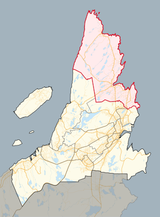
Division 1, Newfoundland and Labrador is a census division covering the entire Avalon Peninsula including the Isthmus of Avalon of the Canadian province of Newfoundland and Labrador. Like all census divisions in Newfoundland and Labrador, but unlike the census divisions of some other provinces, the division exists only as a statistical division for census data, and is not a political entity.

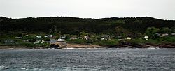
Upper Island Cove, Newfoundland and Labrador is a town in Newfoundland and Labrador. It is located in Division 1, Newfoundland and Labrador census division. It is north east of Bay Roberts. The Way office was established in 1864. The population was 942 in 1940; 1,346 in 1951, 1,563 in 1956, and 1762 in 1966. As of 2021, the population is 1,401.

<span class="mw-page-title-main">Cape St. Francis (electoral district)</span> Provincial electoral district in Newfoundland and Labrador, Canada

Cape St. Francis is a provincial electoral district for the House of Assembly of Newfoundland and Labrador, Canada.

<span class="mw-page-title-main">Torbay, Newfoundland and Labrador</span> Town in Newfoundland and Labrador, Canada

Torbay is a town located on the eastern side of the Avalon Peninsula in Newfoundland and Labrador, Canada.

<span class="mw-page-title-main">Portugal Cove–St. Philip's</span> Town in Newfoundland and Labrador, Canada

Portugal Cove–St. Philip's is a rural seashore community located on the eastern Avalon Peninsula of Newfoundland in the province of Newfoundland and Labrador, Canada. The town is a bedroom community of the provincial capital of St. John's.

<span class="mw-page-title-main">Grand Concourse (St. John's)</span>

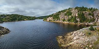
The Grand Concourse is an integrated walkway and green space network connecting 10 municipalities in the Province of Newfoundland and Labrador. It has over 200 kilometers (120 mi) of walkways linking every major park, river, pond, and green space in the Northeast Avalon region. The Grand Concourse is managed by the Grand Concourse Authority, a non-profit organization with a board of directors made up of representatives from a variety of community-based and government groups.

<span class="mw-page-title-main">Newfoundland Tricolour</span>

The Newfoundland Tricolour, or the Pink, White and Green, is an unofficial flag seen in the Canadian province of Newfoundland and Labrador, and is mistakenly believed to have been an official Flag of Newfoundland and Labrador, or more commonly, of the island of Newfoundland specifically.

Bay de Verde is an incorporated town in Conception Bay on the northern tip of the Bay de Verde Peninsula of Newfoundland and Labrador, Canada. The first recorded inhabitants at Bay de Verde arrived in 1662. Bay de Verde became an incorporated town in 1950.

<span class="mw-page-title-main">Pouch Cove</span> Town in Newfoundland and Labrador, Canada

Pouch Cove is a town in the Canadian province of Newfoundland and Labrador. The population is 2,063 according to the Canada 2021 Census. It is located on the northeast Avalon Peninsula, 27 kilometres north of St. John's, the province's capital city.

Noggin Cove is a local service district and designated place in the Canadian province of Newfoundland and Labrador. It is west of Carmanville on the south side of Hamilton Sound. It is said to be named after Noggin Island, about 5 km off its eastern point.

<span class="mw-page-title-main">Logy Bay-Middle Cove-Outer Cove</span> Town in Newfoundland and Labrador, Canada

Logy Bay-Middle Cove-Outer Cove is a town in the Canadian province of Newfoundland and Labrador. It is located within a 10 minutes' drive from downtown St. John's preceding the Town of Torbay on the eastern tip of the Avalon Peninsula.

<span class="mw-page-title-main">Coachman's Cove</span> Town in Newfoundland and Labrador, Canada

Coachman's Cove is a town in the Canadian province of Newfoundland and Labrador. The town had a population of 111 in the Canada 2021 Census.

<span class="mw-page-title-main">Lourdes, Newfoundland and Labrador</span> Town in Newfoundland and Labrador, Canada

Lourdes is a town in the Canadian province of Newfoundland and Labrador. The town had a population of 465 in the Canada 2016 Census. The current mayor of Lourdes is Henry Gaudon.

<span class="mw-page-title-main">St. Bernard's-Jacques Fontaine</span> Town in Newfoundland and Labrador, Canada

St. Bernard's-Jacques Fontaine is a town in the Canadian province of Newfoundland and Labrador. The town had a population of 433 in the Canada 2021 Census, a drop from 470 in 2011.

O'Donnells is a local service district and designated place in the Canadian province of Newfoundland and Labrador. It is southeast of Placentia. The first postmistress was Mrs. Theresa M. Hanlon on July 16, 1951. By 1956 there was a population of 244.

<span class="mw-page-title-main">Newfoundland and Labrador Route 20</span> Highway in Newfoundland and Labrador, Canada

Route 20 is a 30.2-kilometre-long (18.8 mi) provincial highway in Newfoundland and Labrador, extending from St. John's to the towns of Torbay, Flatrock, Shoe Cove, Pouch Cove, and the point of Cape St. Francis. Route 20 is located entirely on the Avalon Peninsula of Newfoundland.

<span class="mw-page-title-main">Newfoundland (island)</span> Island portion of Newfoundland and Labrador, Canada

Newfoundland is a large island situated off the eastern coast of the North American mainland and the most populous part of the Canadian province of Newfoundland and Labrador. The island contains 29 percent of the province's land area. The island is separated from the Labrador Peninsula by the Strait of Belle Isle and from Cape Breton Island by the Cabot Strait. It blocks the mouth of the Saint Lawrence River, creating the Gulf of Saint Lawrence, the world's largest estuary. Newfoundland's nearest neighbour is the French overseas collectivity of Saint Pierre and Miquelon.

<span class="mw-page-title-main">Lourdes grotto</span>

A Lourdes grotto is a replica of the grotto where the Lourdes apparitions occurred in 1858, in the town of Lourdes in France, now part of the sanctuary of Our Lady of Lourdes. Some Lourdes grottos are almost identical reproductions of the scene of the apparitions, with statues of Our Lady of Lourdes and Bernadette Soubirous in a natural or artificial cave, while others may differ from the original in size, shape or style.

Flower's Cove is a town in the Canadian province of Newfoundland and Labrador. The town had a population of 272 in the Canada 2021 Census. It is known for its thrombolite fossils.

References

  1. "The Grotto - Town of Flatrock". Archived from the original on 2008-07-27. Retrieved 2009-06-07.
  2. Religious Shrine Our Lady Of Lourdes - Canada Photos.com
  3. The Scope
  4. "Population and dwelling counts: Canada, provinces and territories, census divisions and census subdivisions (municipalities), Newfoundland and Labrador". Statistics Canada. February 9, 2022. Retrieved March 15, 2022.